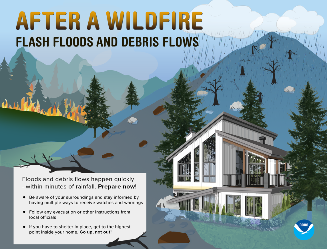
Burn Scars can lead to Post Wildfire Flash Floods & Debris Flows
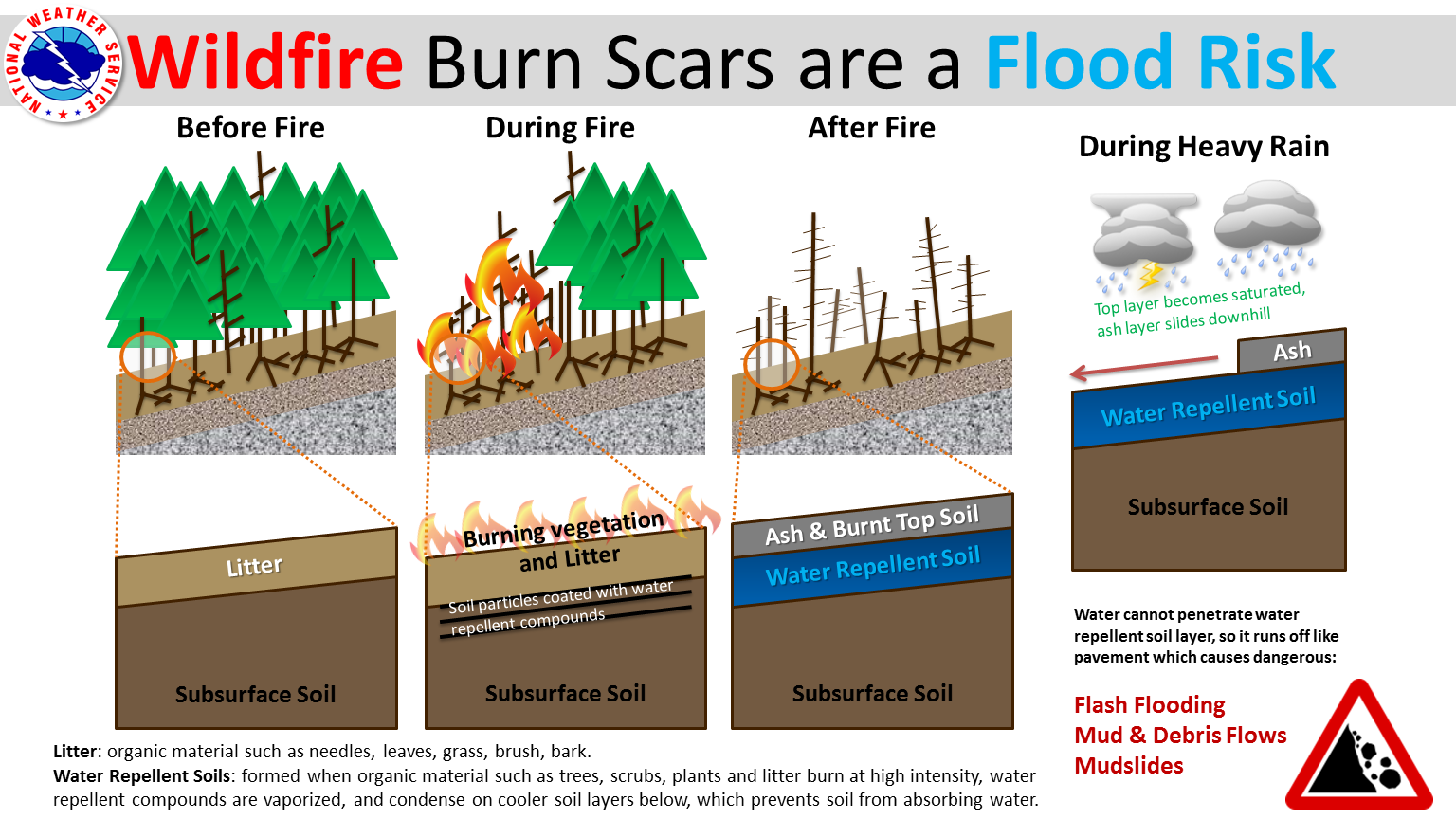
Active fire seasons have had lasting effects on the landscape across the Inland NW over the years, both in the immediate area and locations many miles away. Locations downhill and downstream from burned areas or "burn scars" are very susceptible to Flash Flooding and Debris Flows, especially near steep terrain. Rainfall that would normally be absorbed into the soil runs off extremely quickly after a wildfire, as burned soil can be as water-repellant as pavement. As a result, much less rainfall is required to produce a Flash Flood. A good rule of thumb: "If you look uphill from where you are and see a burnt-out area, you are at risk."
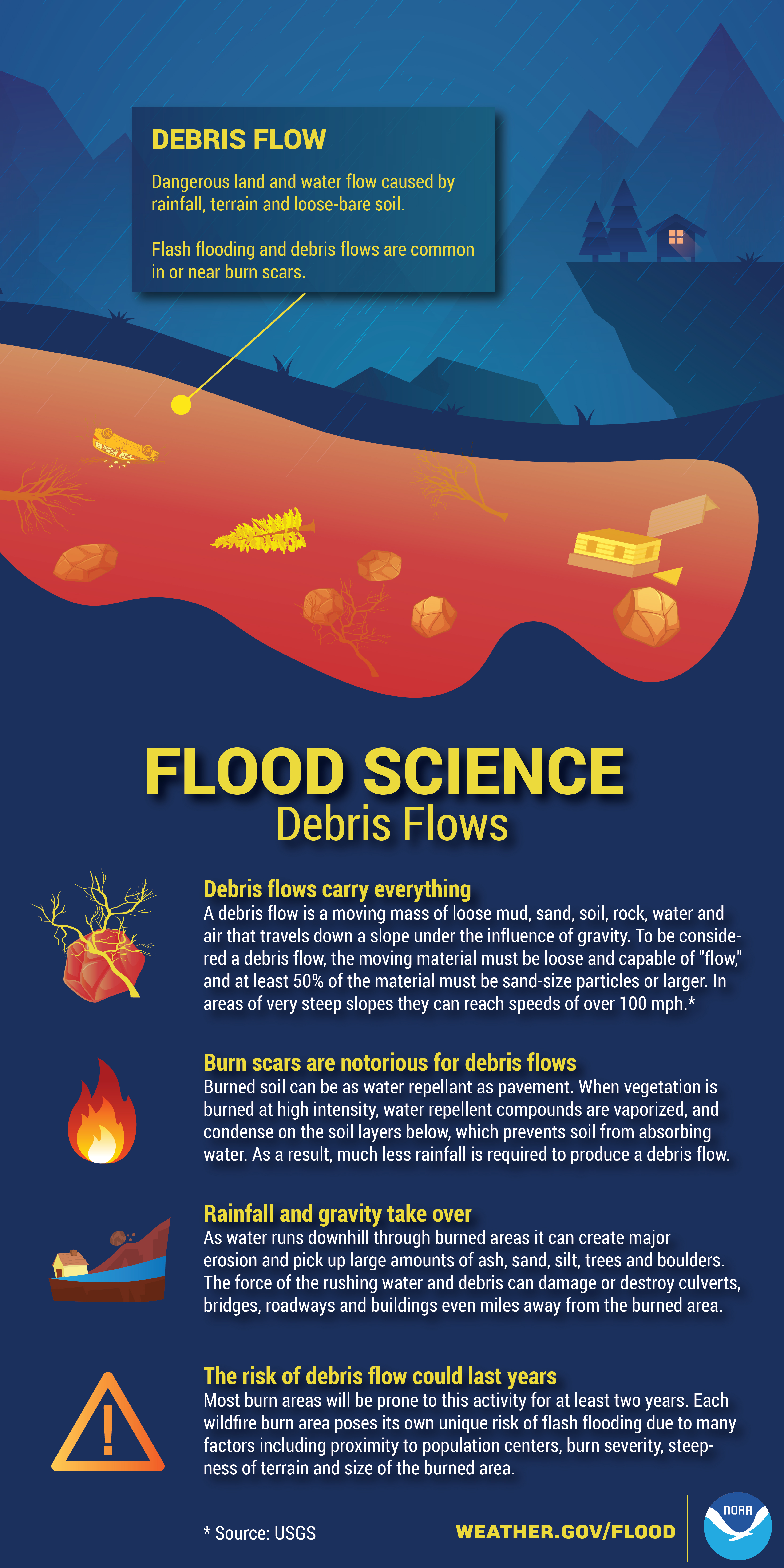
What is a debris flow? Debris flows are fast-moving, deadly landslides. They are powerful mixtures of mud, rocks, boulders, entire trees - and sometimes, homes or vehicles. You'll often hear "debris flows" called "mudslides" or "mudflows". Many people use the terms interchangeably, but to scientists, each is a different kind of landslide and debris flows are the most powerful and dangerous of the three.
What causes a debris flow?
Debris flows occur most commonly during intense rain after wildfires. A debris flow doesn't need a long rain or a saturated slope. It can start on a dry slope after only a few minutes of intense rain. "Intense” rain means a burst of rain at a fast rate, about half an inch or less in an hour. This mostly comes from heavy convective showers or thunderstorms. With debris flows, the rainfall rate matters more than total rainfall.
Why are debris flows so dangerous?
Debris flows are fast and unpredictable. They can travel faster than you can run - and they can catch up to your car! Also, no one can say precisely where a debris flow will start or where it will go. It may begin in a stream channel, then jump out and spread through private properties or even through a town. A debris flow may happen where others have occurred, or in a place that has never seen one before.
What can I do about debris flows?
As an individual, nothing. No one can stop a debris flow or change its path. Many of us are used to protecting our properties with sandbags, culverts, k-rails, or retaining walls. These can help redirect mud and water, but not debris flows.
If you stay at home, that won't protect your property but will endanger you. If you are told to evacuate, leave. That is the only sure way to protect your life from a debris flow is to avoid being in one. Be alert where you camp and recreate, keep alert to burn scar areas.
How can I be prepared and when should I evacuate?
In the event of moderate to heavy rainfall, do not wait for a flash flood warning in order to take steps to protect life and property. Heavy rain that develops over the burned area may begin to produce flash flooding and debris flows before a warning can be issued. If you are in an area vulnerable to flooding and debris flows, plan in advance and move away from the area.
There may be very little time to react once the rain starts. If you hear of an evacuation, leave as soon as you get the word. When it comes to evacuation, many of us are used to wildfires and we stay to "wait and see" whether the danger is coming our way. However, if you wait until you are sure a debris flow is coming, it will be too late to leave safely.
What else do I need to know about debris flows?
Never underestimate a debris flow. People die just about every year in debris flows, but often the affected area is small so the story only makes local news.
Pay attention to weather forecasts for the burn area, which could be very different from where you are. It can be pouring in the mountains while sunny or drizzly at your location.
Know the warning signs that a debris flow is about to arrive. Listen and watch for rushing water, mud, unusual sounds. Survivors describe sounds of cracking, breaking, roaring, or a freight train.
If a debris flow catches you by surprise, your best hope of surviving is to get higher than the flow - get to the top story of your home, on a roof, up a tree.
In every storm, expect uncertainty. Rain can suddenly change direction, location, or intensity, and that changes the chance of debris flows.
When a wildfire burns a slope, it increases the chance of debris flows for several years. The danger does slowly drop over time.
You might be told to evacuate more than once and you could get really sick of leaving. But remember, debris flows are unpredictable. No one can say where the next one will flow.
How much rainfall is required to produce a flash flood after a wildfire?
The time required for a flash flood to begin depends on how severe the fire was and how steep the terrain is, combined with the rate of precipitation. Steep terrain combined with a severe burn scar and light precipitation can result in flash flooding within minutes of precipitation beginning. Areas of less severe burn damage and flatter terrain will be able to absorb more water leading to more time before flooding develops even in heavier precipitation. A general rule of thumb is that half an inch of rainfall in less than an hour is sufficient to cause Flash Flooding in a burn area, but this can be more or less depending on the factors above.
The susceptibility to flash flood within the burned area is greatest during the first two years following the fire. The important point is that for any burn area it will take much less rainfall to result in flash flooding than it would have before the wildfire occurred. In fact, heavy rain that develops over burn areas can produce Flash Flooding and Debris Flows nearly as fast as National Weather Service radar can detect the rainfall. If heavy rainfall is observed even for a very short time there is the potential for Flash Flooding and/or Debris Flows.
How long will there be an elevated risk of Flash Flooding and Debris Flows?
This depends on the severity of the wildfire that occurred as well as how much erosion occurs. It could take many years for vegetation to become re-established and this is the main factor in slowing the precipitation runoff that creates Flash Flooding and Debris Flows. Most burn areas will be prone to this activity for at least two years. Each wildfire burn area poses its own unique risk of Flash Flooding due to many factors including proximity to population centers, burn severity, steepness of terrain, and size of the burned area.
What should people who live near a burn scar do to protect themselves from potential flash flooding and debris flows?
Have an evacuation/escape route planned that is least likely to be impacted by Flash Flooding or Debris Flows
Have an Emergency Supply Kit available
Stay informed before and during any potential event; knowing where to obtain National Weather Service (NWS) Outlooks, Watches and Warnings via the NWS website, FEMA App, or even Facebook or Twitter.
Be alert if any rain develops. Do not wait for a warning to evacuate should heavy rain develop.
Call 911 if you are caught in a Flash Flood or Debris Flow
Contact local officials for additional risk information and potential mitigation efforts