| A Review of Local Weather in 2009 |
The spring severe weather season locally was one of the most active in recent memory with no less than eight events occurring between February 17 and April 13, including five within a 10-day period from March 27 through April 5. The area was deluged with rain during this brief period, which resulted in floods-of-record on the Withlacoochee and Upper Suwannee Rivers. June was notable for the intense heat wave that baked the region from the 2nd into the 4th week. The period from June 16-22 saw the mercury reach or exceed 100 degrees in Tallahassee on seven consecutive days. We fell one degree shy on the 23rd of breaking the record for consecutive 100-degree days. One of the biggest weather stories of 2009 was the return of El Niño which had a significant impact on U.S. and local weather in the 2nd half of the year. The phenomenon kicked in just in time to suppress tropical cyclone development in the Atlantic Basin during what is typically the most active period (from August to October). As can be seen in Figure 1, overall activity was much less than in recent years across the basin. That said, the only two tropical cyclones to make landfall in the U.S. impacted the Florida Panhandle, Claudette in August and the late-season Ida in November. By December, another well-known impact from El Niño became apparent as the southern stream of the jet stream became quite active. Numerous low pressure systems developed in the Gulf of America bringing abundant rainfall to the region and making December 2009 the 3rd wettest on record. El Niño's impacts continued into 2010. Additional details on the impacts of El Niño on the Southeastern U.S. can be found here. Details on the significant severe weather and tropical cyclone events that occurred in 2009 (and previous years) can be found on our Significant Events Web Page.
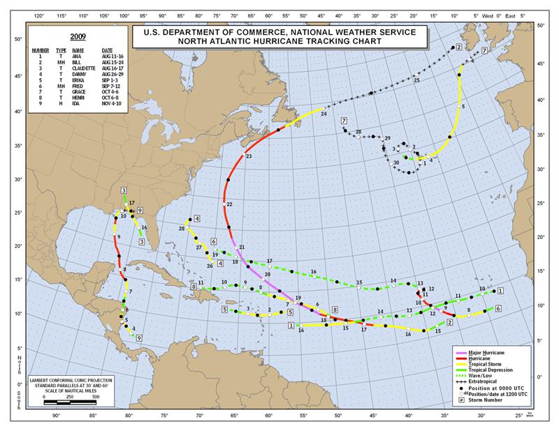
Figure 1. Preliminary storm tracks for the 2009 Atlantic Hurricane Season.
As can be seen in Figure 2 (below), the year started with a mild spell followed by a cold snap during mid January. After another brief warm up, the coldest weather of the winter occurred in the first week of February. The low temperature of 14 degrees on the 5th was the coldest temperature observed at the Tallahassee Regional Airport (TLH) since 12/24/89 and the coldest of 2009. The roller coaster temperature trends continued for the balance of the month and on into March when there were a few subfreezing mornings. The first big warm up of spring occurred then 2nd week of March with the high of 86 degrees on the 12th breaking a record for the date. April saw fairly typical temperatures with the exception of a cold snap on the 7th and 8th. After a daytime high of only 59 degrees on the 7th, the mercury dropped below freezing at TLH for the final time of the season on the morning of the 8th. In a quick reversal of fortune, the mercury soared to 90 for the first time of the season on 4/23 with 91 degrees the next day. Temperatures averaged a bit above normal in May. However, an unseasonably cool period occurred during the 3rd week with daytime highs only reaching 70 and 68 degrees respectively on the 18th and 19th. Both were good enough to set new record low maximum temperatures for the dates. June was an exceptionally hot month, and in fact the 4th hottest June on record. There were seven consecutive days when max temps reached 100 or better at TLH from the 16th to the 22nd. The 103-degree readings on the 20th and 22nd were the hottest of the year and just one degree shy of the all-time highest temperature ever observed at TLH. Temperatures were still hot in July, but far more moderate and actually averaged nearly 2 degrees cooler than June. An unusual mid-summer cold front brought drier air into the region that allowed the mercury to drop into the 60s on 5 consecutive mornings from the 19th to the 23rd. The low of 60 on the 21st was the coolest of the month. There was another cold front in late August that brought min temps into the lower 60s on three consecutive mornings from the 23rd to 25th. Otherwise the month was typically muggy. September saw near normal temperatures, but the first true cold front of the fall season dropped the mercury into the upper 40s on the morning of the 30th. As is typical of autumn in Tallahassee, this was just a tease, as we were in for one more hot spell. Temperatures reached or exceeded 90 degrees on seven consecutive days from the 6th through the 12th before plummeting during the 3rd week after what can be considered a season changing cold front swept through the region. Temps dropped into the 30s on the mornings of the 19th and 20th and with the 19th tying a record low. The daytime high of 60s degrees on the 17th set a new low maximum temperature record for the date. Temperatures shot up one more time at month's end, nearly reaching 90 on the 29th. November was generally cooler than average with the first freezing temperature of the season occurring on the morning of the 27th at TLH. This was very late in the year to see the first freeze, and a marginal one at that. December had near normal temps with wild fluctuations. Only four days dipped below freezing at the airport.
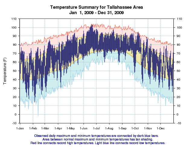
Figure 2. Temperatures in Tallahassee during the year 2009.
Figure 3 (below) shows that Tallahassee started out the year on a very dry note over the first three months of the year. Only one significant rainfall event over an inch occurred before the 26th of March. By March 25th, the rainfall deficit for the year stood at around 11 inches and we were on par with the driest year on record at that time. Then the flood gates opened up, literally. From March 26th to April 13th, over 15 inches of rain fell in Tallahassee with nearly a foot in an 8-day stretch from march 26th to April 2nd. Over 6.5 inches of rain fell on the first two days of April alone. Even though it only rained one more time in April after the 13th, the month still came in as the 6th-wettest April on record and the wettest in 30 years. May had near normal rainfall, starting out dry and then seeing regular rainfall in the 2nd half of the month. June saw a brief wet period at the beginning and end of the month, but was largely hot and dry. Rains occurred regularly from July through September, but at much lower rates than normal and the deficit grew steadily once again. This trend continues through the autumn months. All that came to an abrupt end in December, when a true El Niño pattern commenced. Heavy rains occurred on several occasions during the month and December 2009 will go into the books as the 3rd wettest on record. Rainfall rivaled that observed during the wettest year on record.
The wettest calendar day of the year was December 2nd, when 5.34 inches of rain fell. The wettest 24-hour period was the 6.56 inches from April 1st-2nd. The driest month was January with just 1.27 inches of rain. The annual rainfall total for 2009 was 58.11 inches in The Capital City, which is 5.10 inches below normal.
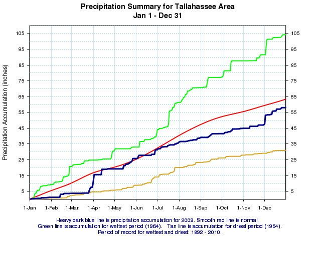
Figure 3. Rainfall in Tallahassee during the year 2009 (blue) versus normal (red). The wettest and driest years on record are shown in green and gold.
Previous Years
Reviews of local weather in 2008, 2007, 2006, 2005, 2004, 2003, 2002, 2001 and 2000 are also available.
National Weather in 2009
NCDC provides a review of annual weather across the nation in 2009 including significant events.

