NWS Tallahassee is proud to announce that recordings of official NWS forecasts and observations are now available over the phone at (850) 942-8851. Using a menu system, you can now listen to current weather and forecast information that is played on NOAA Weather All Hazards Radio, including the local forecast, marine forecast, daily tides & sunrise/sunset information, the hourly weather roundup, and tropical information (if available). You can also speak directly to a National Weather Service Tallahassee forecaster 24 hours a day by calling (850) 942-8833. For continuous weather information, consider purchasing a NOAA Weather All Hazards Radio. These specially designed receivers provide up-to-the-minute information on local weather and immediate broadcast of severe weather warnings. The NOAA Weather Radio broadcast originates at the National Weather Service office in Tallahassee.
The colors represent different watch, warning, and advisory products issued by the National Weather Service. Additional details and a color key are available here.
The National Weather Service (NWS) issues Red Flag Warnings & Fire Weather Watches to alert land management agencies of the onset, or possible onset, of critical weather and fuel moisture conditions that could lead to rapid or dramatic increases in wildfire activity. To learn more about these products, please refer to our web page on the topic.
Most of the more commonly used technical words and acronyms in our Area Forecast Discussions (AFDs) will appear as hyperlinks. Just click on the word, and a brief definition or explanation will appear in a pop-up window. A more complete weather glossary is available here and at the top of each AFD.
Since the Interactive Marine Observations pages are used worldwide, we have a created a separate page just for questions related to the buoy network. Refer to the Marine FAQ tab at the top of this page. For marine forecasts and information on tides and other marine-related items, please refer to our Marine Weather page.
If there are active tropical systems in the Atlantic basin (N. Atlantic, Caribbean Sea, Gulf of Mexico), you can refer to our office's Tropical Weather page for the latest. Information from the latest advisories issued by the National Hurricane Center, for any named storm west of 60 N and south of 35 N, can be obtained twenty-four hours a day by dialing (850) 942-8833, selecting option 1, then option 6. Most other information related to hurricanes and tropical storms can be obtained from the National Hurricane Center. Some of the more common questions about hurricanes are addressed on the Tropical FAQ tab at the top of this page.
The first thing you should do is click the refresh or reload button on your web browser. If you recently visited our site, an old version of one of our products may be stored in your cache. If so, that one will be loaded into your browser. Sometimes, however, our server goes down which prevents the latest products from being posted. If this occurs, please notify the webmaster. Unfortunately, we cannot provide 24/7 support for this web page so it may take some time t.o fix the problem.
If you are interested in climate information for Tallahassee or other cities in Florida, Alabama, or Georgia ; refer to our Climate Data page. If you are looking for historical weather information for other U.S. locations, you can contact the National Climatic Data Center, one of the Regional Climate Centers, or one of the State Climatologists for your area of interest.
WSR-88D (NEXRAD) data is now available directly from the National Weather Service. Use the interactive national interface to access Doppler radar data for anywhere in the 50 states, Puerto Rico or Guam. To zoom in, click on area of interest on map and it will take you to the closest radar page. Four products are available: base reflectivity, composite reflectivity, one-hour radar estimated precipitation, and storm-total radar estimated precipitation. Each local radar page has a zoom feature and can be looped. There is also a handy interface in the upper left hand corner that allows you to jump easily between adjacent radars.
While the National Weather Service does provide forecasts and observations for the entire United States, its territories and possessions, most of the data available via our home page at Tallahassee is specific to Florida, Georgia, or Alabama. However, we have included some helpful search engines to help you find information about weather elsewhere in the country. At the upper left of each of our web pages, you will find the "City-ZIP" search, which will allow you to search for weather information for any city or ZIP code nationwide. The NWS search near the upper right side of each page will allow you to do a general search of all NWS pages around the country. If you are having trouble finding a particular page on our site, use this search engine.
Please see the winter tab at the top of this page.
A Small Craft Advisory is issued to alert operators of small craft whenever sustained winds of 20 to 33 knots inclusive, and/or seas of 7 feet or greater, are either ongoing or forecast to develop within the next 12 hours. This criteria is uniform for all U.S. Gulf of Mexico coastal waters, but may differ along the Atlantic or Pacific coasts. There is no official definition for the term "small craft" in the National Weather Service. However, the U.S. Coast Guard considers any vessel less than or equal to 33 feet to be a small craft. The smallest, most weather-sensitive boats can experience problems in lower winds and seas. For this reason, the headline, "Small Craft Exercise Caution," is placed in the forecast for current or predicted winds of 15 to 20 knots and seas of 4 to 6 feet.
A Gale Warning is issued to alert all mariners whenever sustained winds of 34 to 47 knots, associated with a non-tropical system, are either ongoing or forecast to develop within the next 12 hours. Winds in this range associated with a tropical system would be covered under a Tropical Storm Warning (34 to 63 knots). Sustained winds above 47 knots outside of tropical systems are very rare in the Gulf of Mexico. However, if these conditions are observed or predicted, a Storm Warning will be issued. Beginning in 2008, NWS began issuing Gale Watches. These give an extra heads up that gale conditions are possible and are issued 24-48 hours ahead of an anticipated event.
Visit the National Data Buoy Center web pages for this data. Their main page is found at http://www.ndbc.noaa.gov/. NDBC is the organization that maintains the nation's buoy network. To learn more about the NDBC, take their online tour on the about NDBC page. Also be sure to check out their FAQ page.
Occasionally, a sensor on one of the buoys or platforms malfunctions. This can occur for a number of reasons including exposure to the elements, collision with watercraft, or simply old age. Data outages are intended to be temporary. To determine if a particular sensor has failed, refer to the latest weekly status report from NDBC, particularly the Remarks sections. If your sensor of interest has failed, check to determine if and when station maintenance has been scheduled.
The buoys in all five Great Lakes are retrieved seasonally to prevent them from being damaged by lake ice. Typically, the buoys are removed in November or December and returned to service in April.
Significant wave height is the mean (or average) of the highest 1/3 of the waves observed by the buoy during the wave sensing period. The buoys measure the wave heights using an accelerometer which measures the vertical acceleration of the buoy every 2/3 of a second over a 20 minute sampling period. Significant wave height is what we try to forecast in the National Weather Service.
The wind wave height is that portion of the significant wave height that was caused by the local wind. The remaining portion is listed as swell height. Swells are older waves that migrated into the local area but were generated by the wind at some distant location at some time in the past.
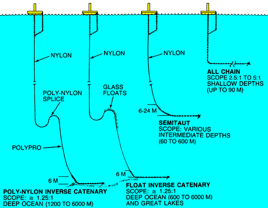
The type of mooring used depends on the hull type of the buoy, the location of the buoy, and the water depth. For example, a smaller buoy in shallow coastal waters is moored using an all-chain mooring. On the other hand, a large discus buoy deployed in deep ocean requires a combination of chain, synthetic nylon, and polypropylene. Moorings are designed for a 6-year life, but often last 10 years. The moorings occasionally break allowing the buoy to go adrift. If possible, the buoys are retrieved and redeployed. Click here to see a graphic of the various buoy moorings.
1kt = 1.15mph. In other words, take the winds speed in knots and multiply by 1.15 to get mph. By the way, a knot is a nautical mile per hour. To convert other meteorological parameters, refer to this on-line weather calculator.
Please refer to this Marine FAQ page maintained by our national headquarters. Hopefully you'll find your answers there. If not, give us a call during normal business hours at (850) 942-8833, ext. 9.
The hurricane season in the Atlantic Basin, which includes the North Atlantic Ocean, Caribbean Sea and Gulf of Mexico, runs from June 1 to November 30 each year. In the eastern Pacific, the season begins on May 15 and ends November 30. Of course, hurricanes and tropical storms can and do form outside these time periods, albeit rarely. In 2003, Ana was the first tropical storm of record to develop during the month of April. Odette and Peter both developed in December of that same year, after the official end of the hurricane season. This marked the first time since 1887 that two tropical storms formed in the month of December. These three storms made the 2003 hurricane season one of the longest in the Atlantic Basin since records began.
Atlantic tropical systems are named from lists maintained and updated by an international committee of the World Meteorological Organization. Six lists are used in rotation. Thus, the 2011 list of names will be used again in 2017. At the beginning of each season, the first storm is always the A storm no matter how many storms formed in the previous season. A separate set of six name lists is used for Eastern Pacific storms. For storms that form elsewhere in the Pacific Ocean, around Australia and Papua New Guinea, or in the Indian Ocean, names are used sequentially. In other words, if the last storm of the 2016 season was the M storm, the first storm of the 2017 season will have a name beginning with N. When the bottom of one list is reached, the next name is taken from the top of the next list.The only time that the name lists are changed is if a storm is so deadly or costly that the future use of its name on a different storm would be inappropriate for reasons of sensitivity. To see the various name lists for the world's tropical systems and to learn more about the retirement of hurricane names, please see the National Hurricane Center's page on the topic at http://www.nhc.noaa.gov/aboutnames.shtml.
When a tropical system first begins to organize, it is initially called a tropical depression. Once sustained wind speeds reach 39 mph, the system is upgraded to a tropical storm and given a name. If a tropical storm intensifies to the point where sustained winds reach 74 mph or greater, it is classified as a hurricane. The strength of a hurricane is categorized by the Saffir-Simpson scale. There are five categories on the scale which are used to estimate the storms potential for property damage and flooding were it to make landfall. Details about the Saffir-Simpson scale can be found at http://www.nhc.noaa.gov/aboutsshs.html.
Descriptions of the various models that are used by the National Hurricane Center to make official intensity and track forecasts can be found here.
NOAA & FEMA maintain a Hurricane Preparedness Web Site with plenty of useful information to help you make informed decisions about preparing your property and family for the potential impacts of a tropical storm or hurricane. Another version of the website is available en Español. This website is updated and highlighted each year before the beginning of Hurricane Season during Hurricane Preparedness Week. In 2016, Hurricane Preparedness Week ran from May 15-21.
Answers to an abundant collection of Frequently Asked Questions are available on the National Hurricane Center's web site.
Most people don't think of snow when the think of Florida. However, newcomers to the area, especially those that hail from the northern climes, may be surprised to learn that it has snowed in Florida many times. In Tallahassee, measurable snow has not fallen since 1989, so we are overdue. NWS Tallahassee Climate Focal Point, Tim Barry, responded to an inquiry from a reporter for Florida State Universtiy's FS View & Florida Flambeau, concerning snow climatology in Tallahassee. The Q & A is included below.
| Decade | All Occurrences (trace or more) |
Measurable Snowfalls |
| 1891-1900 | 3 | 2 |
| 1901-1910 | 0 | 0 |
| 1911-1920 | 3 | 0 |
| 1921-1930 | 0 | 0 |
| 1931-1940 | 0 | 0 |
| 1941-1950 | 1 | 0 |
| 1951-1960 | 8 | 3 |
| 1961-1970 | 4 | 0 |
| 1971-1980 | 6 | 1 |
| 1981-1990 | 3 | 1 |
| 1991-2000 | 3 | 0 |
| 2001-2010 | 2 | 0 |
| 2011-present | 3 | 1 |
| Totals | 32 | 7 |
From the information provided in the 1st question, we see that it snowed 32 times in Tallahassee since 1891. Please note that all but 7 of these occurrences were only Trace amounts. If we were to divide the period of record (113 years) by 32 we would get a frequency of once every 3.5 years. But as you can see from above, the more frequent occurrence of snow in the 50's ,60's and 70's have skewed the results. The return period for measurable snow is, on average, just once every 16 years.
The best synoptic set up for seeing snow in Tallahassee is to have a cold airmass in place over the region and have a weak low pressure system develop over or move eastward across the northeast Gulf of Mexico. If the system is too strong, the southerly flow would push a warm front northward and we would end up in the warm sector (not good). The low pressure system that I am referring to is very similar to the one that just occurred Friday, January 9th. The reason we didn’t see snow was obvious. The temperatures were not even close to being cold enough with readings that day in the 50s. Also, just to have cold air in place at the surface is not good enough. The depth (thickness) of this cold air is critical. If it is not thick enough, we could end up getting a cold rain, sleet, or if the surface temperature is 32 degrees F or below; freezing rain.
I would not say freak, but for all weather parameters to come together as mentioned in the above question, it is not very probable.
We don’t need a gulf low to get snow in Tallahassee but that is our best scenario. A strong cold front can bring a chance for snow but there has to be some lingering moisture when the cold air arrives. More often than not, by the time the cold temperatures arrive that would support the frozen precipitation, the moisture is long gone.
The most snow recorded in a 24-hour period was 2.8" from February 12th - 13th, 1958 .
The National Weather Service does not forecast seasonal chances for snow.
The public forecasts provided by the National Weather Service only extend out to 7 days. The Climate Prediction Center (CPC) issues seasonal forecasts which can be found here.
Northerners like myself, who move to Tallahassee may be surprised to learn that it does get cold here during the winters. There is a significant difference between the climate of north Florida and the southern portions of the peninsula. On average, we experience 35 days with minimum temperatures at or below freezing with most of these occurring from December through March. The coldest temperature ever recorded in Tallahassee was -2 F on February 13th 1899. More recently, we dipped down to 6 degrees F on January 21st, 1985.
Yes. The decision to keep schools opened or closed has to be made in most cases before the events even start. Therefore, just the mere threat of snow has prompted the local school authorities to close schools in the past. Fortunately, when we had our last measurable snow of 1", schools were closed for the Christmas break.

