
Extreme heat continues today from the central Plains to the lower Mississippi River Valley, over southeast Montana, and from southern California into the Southwest Deserts. Extreme Heat Warnings remain in effect. Severe thunderstorms capable of strong to severe wind gusts and large hail are possible across the Great Lakes into the Ohio Valley today into tonight. Read More >
The Blizzard of 1949 is considered one of the worst on record for the northern Plains. The first storm began January 2 and continued through January 5, with heavy snow, strong winds and cold temperatures. Subsequent storms through mid-February produced enormous snow drifts that paralyzed much of the region. Roads and railroads were blocked, so airplanes were used to bring food and medical supplies to isolated towns and hay to livestock.
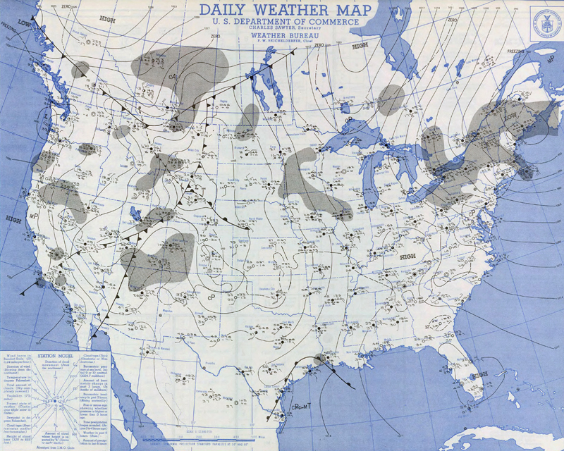
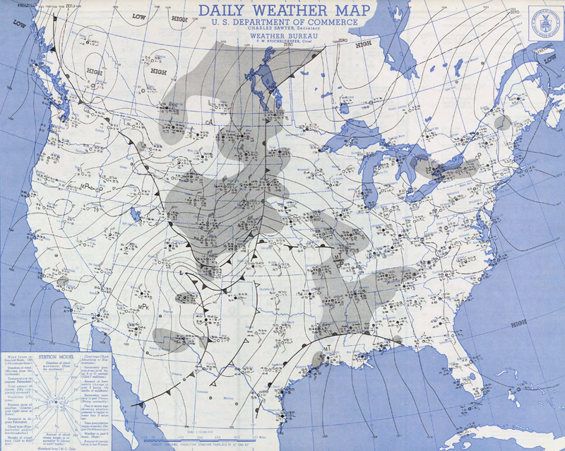
Daily Weather Maps for January 2 and 3, 1949
While only one person died in western South Dakota, twelve deaths were reported in Wyoming, seven in Colorado and 20 in Nebraska. (“Some Outstanding Blizzards”, U.S. Department of Commerce, Environmental Science Services Administration, Environmental Data Service, Revised December 1966).
Rapid City Weather Bureau Office Meteorologist-in-Charge Fred H. McNally wrote “This is rated as the most severe blizzard in Rapid City history, considering wind, snow and temperature factors.” The average wind recorded by the Weather Bureau Airport Station (WBAS) at the Rapid City Municipal Airport [now Ellsworth Air Force Base, 10 miles northeast of Rapid City] on January 3 was 51.8 mph and on January 4 was 55.7 mph with the highest single mile of wind 73 mph [Note: The anemometer was located 19 feet above the roof of the office or 63 feet above the ground, compared to the current wind equipment at a height of 33 feet above the ground]. The Air Force Base Weather Office, across the field from the WBAS, reported gusts in excess of 90 mph. Snowfall from January 2-5 ranged from several inches to several feet. Temperatures dropped below well zero across northwestern South Dakota.
January 1949 is the snowiest January on record for many of the observing stations in the Black Hills region. Snowfall during the month ranged from 12 to over 40 inches—three to eight times the normal of four to eight inches. It was also one of the coldest Januarys recorded, even with several days between blizzards reaching highs in the 50s and even 60s.
Two accounts of the storm, including personal stories from South Dakota and Nebraska residents, were written by Harl A. Dalstrom and Kay Calame Dalstrom:
“It’s ‘Going Down in History’: The Blizzards of 1949”, South Dakota History 29 (Winter 1999): 263-326
"I’m Never Going to Be Snowbound Again: The Winter of 1948-1949 in Nebraska", Nebraska History 82 (2002): 110-166
Another account was provided by Mr. Wayne Park, who had just arrived at Fort F.E. Warren Air Force Base in Cheyenne, WY.
Readers may send their memories of the blizzard by email to w-unr.webmaster@noaa.gov use Blizzard of 1949 as the subject line or write to National Weather Service, 300 E. Signal Dr, Rapid City, SD 57701.
The magnitude of the storm was captured in pictures by the Rapid City Daily Journal:
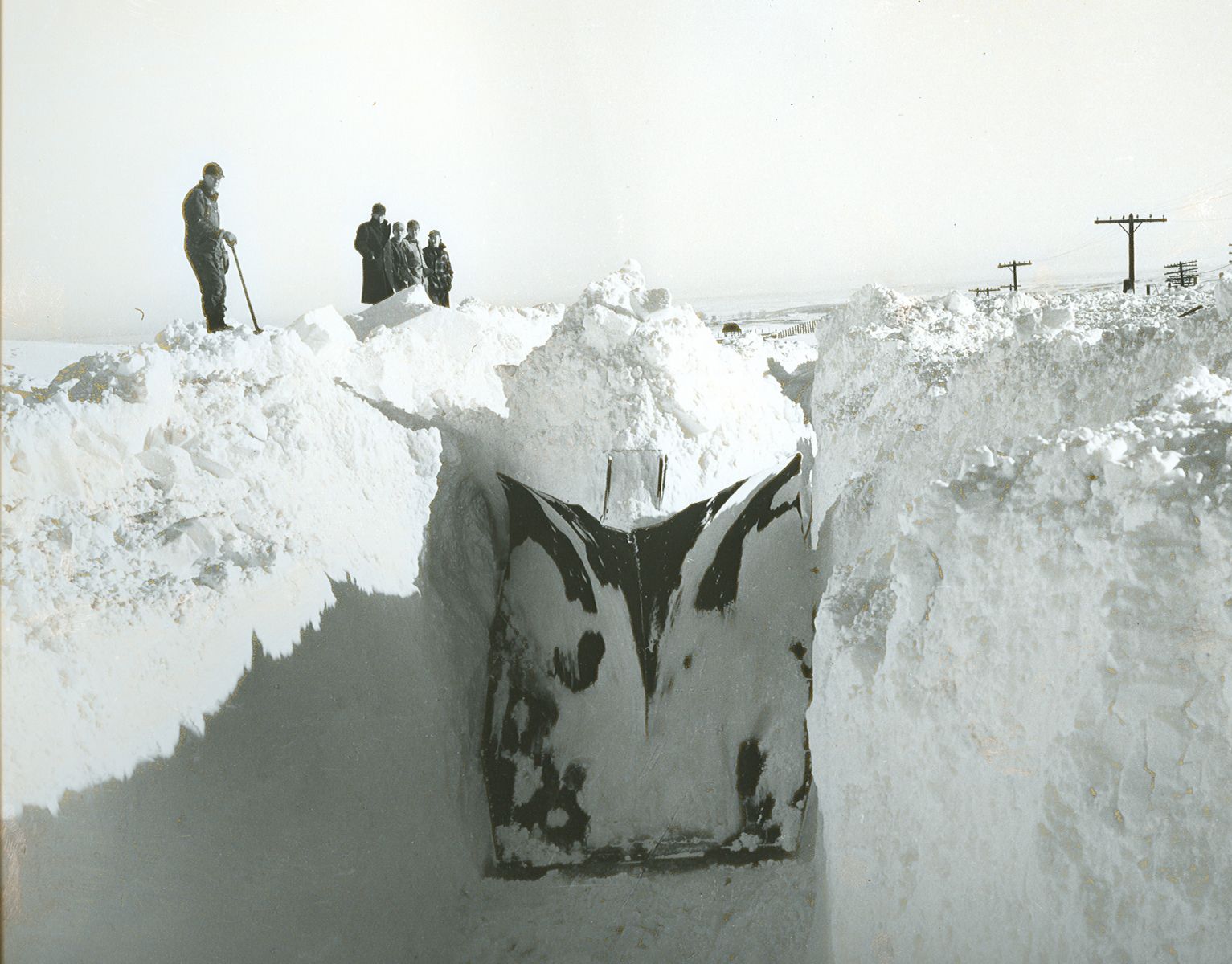
The railroad plow which bored through on the North Western line from Pierre east of Rapid City after dynamite as used to loosen ice-encrusted snow. Photo courtesy of the Rapid City Journal.
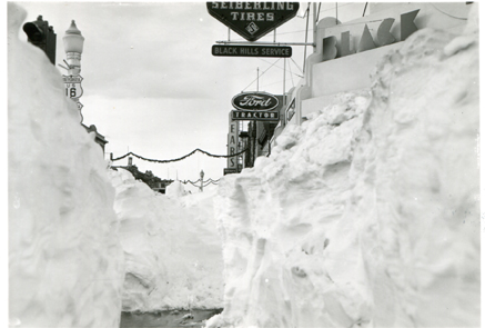
Downtown Rapid City after the blizzard. Photo by the Rapid City Journal.

