
Dangerous and extreme heat will remain across portions of the southern U.S. this week. Heavy rainfall may bring significant flash flooding across portions of the Mid-Atlantic and Northeast through the night, and additional flash flooding concerns across New England on Wednesday. Monsoonal thunderstorms will bring a flash flood risk to the Four Corners region, especially in burn scar areas Read More >
This article is a brief description of the "Holy Week Blizzard" of 2000 (so called because it occurred during Holy Week between Palm Sunday and Easter), a storm which accounted for one to three feet of very heavy, wet snow over much of the Black Hills and surrounding plains on April 19. The storm caused a considerable amount of damage--mostly snapped trees and downed utility poles--and effectively shut down communities in the Black Hills and the eastern foothills from very early on April 19 through the afternoon of April 20.
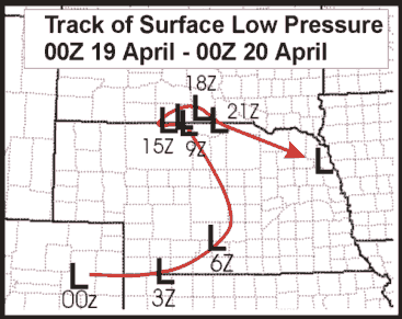
Showers and thunderstorms began moving into northeastern Wyoming and southwestern South Dakota between 2:00 and 6:00 PM MDT Tuesday, April 18 as a surface low pressure center moved eastward into south central Nebraska. Moderate rain reached Rapid City by 7:15 PM MDT, with moderate to heavy rain and some thunderstorms over most of southwestern South Dakota by 8:00 PM MDT. Very little precipitation extended west and north of a line from Wright to Sundance, Belle Fourche, and Faith. By 8:50 PM MDT, a spotter near Deerfield--at 6100 feet MSL in the central Black Hills--reported big snowflakes and 32 F; by 9:25 PM MDT, another spotter at Rochford--at 5600 feet MSL in the northern Black Hills--reported snow. By 12:15 AM, snow was falling just southwest of Rapid City along Sheridan Lake Road.
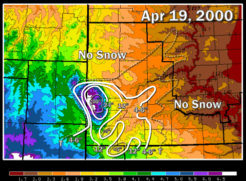
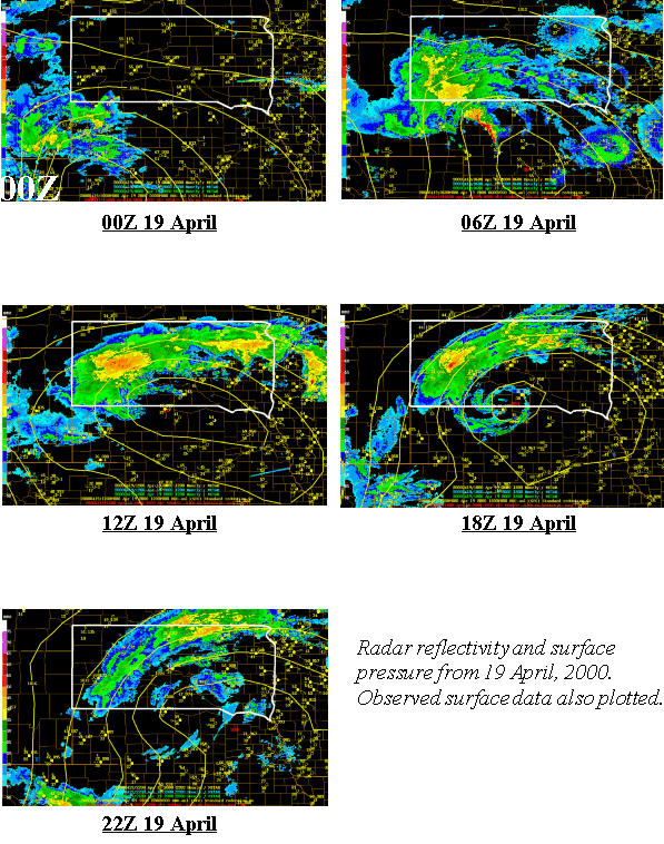
At 1:30 AM, a mix of snow and sleet was falling in Rapid City (3200 feet MSL). Radar images continued to show heavy precipitation with embedded thunderstorms from 8:00 PM to 3:00 AM MDT over the Black Hills and southwestern South Dakota, with continued redevelopment on the southern edge of the precipitation shield over Fall River through Bennett Counties. After 3:00 AM MDT, the heaviest precipitation shifted toward west central South Dakota, with convective bands being advected into the Rapid City area from the northeast. Meanwhile, little or no precipitation was falling over northeastern Wyoming, northwestern South Dakota, and south central South Dakota during this time. This pattern persisted through the morning and into the early afternoon, with a slow decrease in overall areal coverage as the band of snow became narrower. After 2:00 PM MDT, the precipitation diminished from the northwest with the narrow snow band gradually moving to the east as the upper low weakened and moved from the area (See Figure 1). Winds during the storm were sustained at 35 mph with gusts over 45 mph. Ellsworth AFB recorded a peak wind of 70 mph.
Liquid precipitation amounts generally ranged from two to four inches across the area. Snowfall of 18 to 33 inches was common throughout the Black Hills and the eastern foothills, with 12" or less just to the east of the Black Hills. Northwestern South Dakota and northeastern Wyoming received little snow or precipitation. The snowfall distribution with the storm is shown below. Extensive tree damage was caused by the heavy, wet snow and power outages lasted over a week in some areas. Preliminary damage from the storm was estimated around 3.0 million dollars, which did not include damage to trees in the Black Hills National Forest. The snow in some locations in the central and southern Black Hills was the greatest amount ever recorded during a single storm and most of the snow fell in less than 12 hours.
Location |
04/19/2000 |
| Hot Springs | 12" |
| Custer | 24" |
| Hill City | 24" |
| Pactola Reservoir | 24" |
| Rapid City Airport | 14-18" (unofficial) |
| Ellsworth AFB | 18.7" |
The blizzard which pounded western South Dakota on April 19, 2000 was a classic "Spring-type" blizzard event over the Northern High Plains. It exhibited a strong, cut-off circulation through much of the troposphere, copious moisture, and slow movement. The storm produced very heavy precipitation over much of the Rapid City forecast area through a combination of both very strong synoptic forcing and upslope enhancement. The motion of the storm was somewhat different than several of our worst blizzards during the previous five years, moving in almost a due easterly direction, as opposed to the more typical northeasterly direction. The eastward motion of the storm, and its position south of the area made the conditions right for the heaviest precipitation to fall on the eastern and northeastern portions of the Black Hills rather than the more typical northern Black Hills.
The lower-tropospheric trough moved nearly west to east across the South Dakota-Nebraska border during the time of the heaviest precipitation from 9 PM MDT on April 18 through 3 PM MDT on April 19. Initially tilted westward with height from 6 PM MDT through 3 AM MDT, the trough became vertically-stacked from 3 AM to 06 AM MDT, and as a result, experienced a slowdown of its eastward progression. The surface low center, initially moving eastward across extreme southern Nebraska from 6 PM MDT through Midnight MDT, rapidly re-developed to the northwest over the South Dakota-Nebraska border by 2 AM MDT, likely in response to the vertical stacking of the trough. The surface low remained virtually stationary for the next 12 hours. The configuration of the lower tropospheric trough and the surface low engendered a wind environment that favored upslope enhancement of the precipitation on the eastern and northern part of the Black Hills and foothills with shallow north winds near the surface and strong northeast winds aloft. Moreover, the very slow (or stationary) motion of the storm from 3 AM through 2 PM enabled these favorable conditions to persist longer than a ‘typical' blizzard of this type, accounting for the anomalously heavy precipitation.
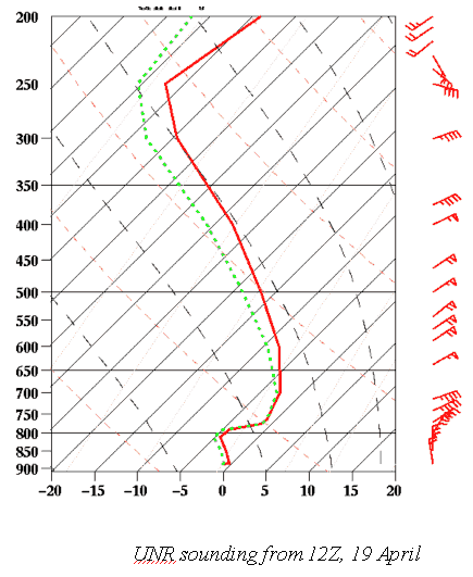
The 12Z sounding on the 19th illustrated the thermal and wind profile for this event during its most intense, seen below. A shallow layer (2000-3000 ft) of northerly winds extended up from the surface, which likely brought evaporatively cooled air from the north and created an anomalously cold pool of air –2 to –5 C. Above this layer was a significant inversion (4 deg C), and a quasi-isothermal layer that extended upward to about 700 mb, with strong winds from the northeast. Because of the shallow nature of the northerly flow, and the strong inversion around 800 mb, the ‘classic' upslope/downslope signature did not develop this day as the shallow inversion kept much of the boundary-layer flow from rising over the hills, but rather diverted a significant portion around them. The northeasterly flow above the inversion likely contributed the most to the distribution of precipitation around western South Dakota, with the northern and eastern parts of the hills receiving the brunt of the moisture, with lesser amounts to the south and west where the flow was downsloping.
The medium range guidance on this storm was representative and very consistent, and led to the release of several statements indicating the possibility of a heavy snowfall event as early as Saturday afternoon (15 April). The Spectral model guidance was particularly consistent in indicating a heavy precipitation event, and the shorter-range guidance (36-60 hr) from the ETA and NGM also were consistent with bringing in significant precipitation, with heavy snowfall in the Black Hills. QPF output from the runs leading up to the event were consistently 2.5" - 4". A significant "glitch" in the model guidance was the 00Z ETA run on the 19th, which had the storm tracking further to the south and exiting the region faster, producing much lower QPF values, and giving the illusion that the storm would be exiting much faster than it really did. It is uncertain why the 00Z ETA model was erroneous.
Another problem that the models had during the event was the boundary layer temperatures, and therefore, the snow level during the event. The models were consistent in forecasting snow for the Black Hills (above 4000' or so), and a cold rain for the surrounding plains, with a changeover to snow in the Rapid City during the morning of the 19th. Not only were the model forecasts several degrees too warm in the boundary layer, but they also wanted to warm up the surface throughout the day on the 19th (during the storm), which was unrealistic.
Forecast model sounding consistently illustrated 850 mb temperatures cooling to below 0C by 12-13Z on Wednesday, with a likely changeover to snow in the Rapid City area soon after. However, snow was reported in the foothills west of town by 12:15 AM, with snow in the Rapid City area by 1:00 AM. At the time of snow conversion in the Rapid City area (6Z-7Z), the ETA forecasts (and other models) had 850 temperatures of 3.6 - 4.3 C (12Z 18 April run), 3.4 - 4.5 C (18Z 18 April run), 1.5 - 2.3 C (00Z 19 April run), and 1.6 - 2.2 C (06Z 19 April run). Obviously, the models were too warm by several degrees at the time the rain turned to snow. The 12Z sounding (Figure 4) also illustrated minimum boundary-layer temps much colder than were forecast by the models. Observed temperatures were around -4 to -4.4 C from 800 to 825 mb. Forecasts valid at this time from previous runs of the ETA model were -1C (from the 12Z 18 April run); -1.3 to -1.8 (18Z run); -1.5 C (00Z run); and -1.3 C for the 06Z 19th run. The pertinent question here is, why didn't the models catch on to the cold air?
Comparison of the model and observed surface data early in the development of the event indicates why the ETA model (and other models) may not have been forecasting sub-freezing temperatures in the boundary layer. From 00Z - 09Z on the 19th, dewpoint temperatures over northern South Dakota and southern North Dakota were quite low, decreasing from 30F down to 12 - 22F. Model forecast dewpoints over this same time period were much warmer, barely achieving sub-freezing values. It is hypothesized that very dry low-level air was being advected into the precipitation shield from the north and northeast, and evaporatively cooling the boundary-layer airmass over western South Dakota to significantly below freezing. Because the models did not indicate the dry air to the north, they were unable to forecast the magnitude of cooling which would take place, and therefore were much too warm in the boundary layer.
This storm was certainly an interesting chapter in the weather over western South Dakota.

