
Dangerous heat will expand from the Gulf Coast into the Southern Plains and Desert Southwest through week's end. Additional extreme heat impacting the Pacific Northwest will shift to the northern Plains by the weekend. Tropical Storm Bertha is expected to continue to impact portions of the northern Gulf Coast from the western Florida Panhandle to southeastern Louisiana through tonight. Read More >
Overview
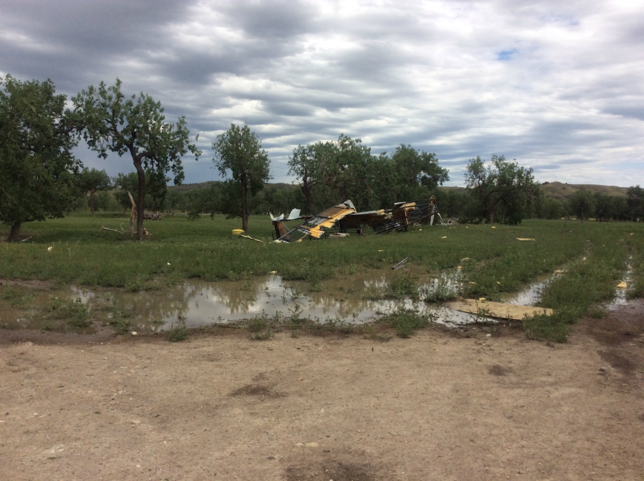
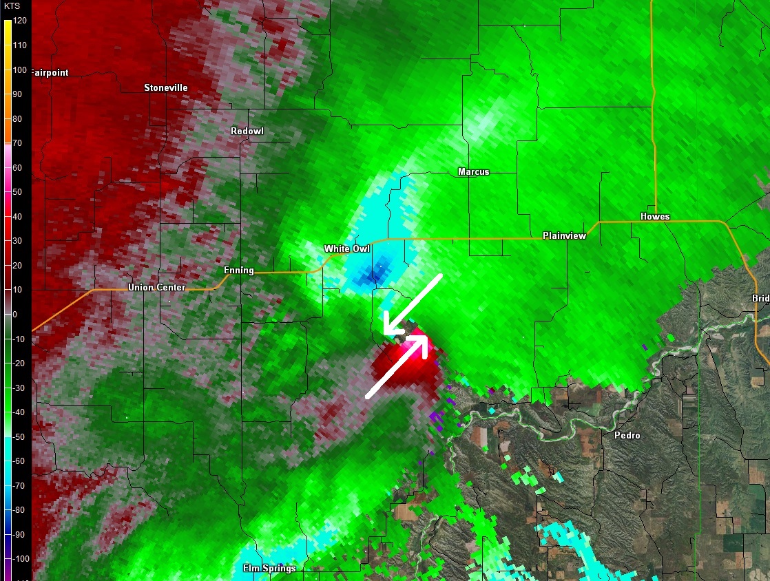
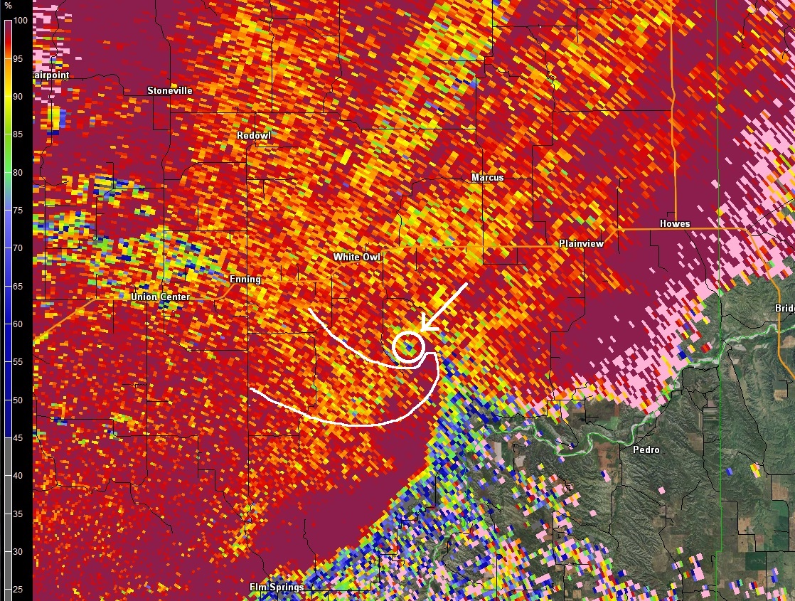
A storm formed over northwestern South Dakota and moved across Meade County. It produced a small tornado south of White Owl, then produced extreme wind gusts over 100 mph south of Plainview.|
Tornado - White Owl, SD
Track Map 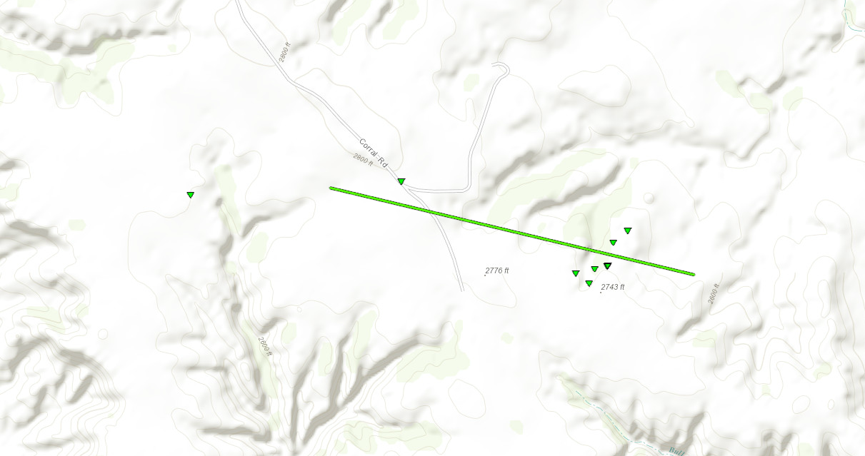  |
||||||||||||||||
 |
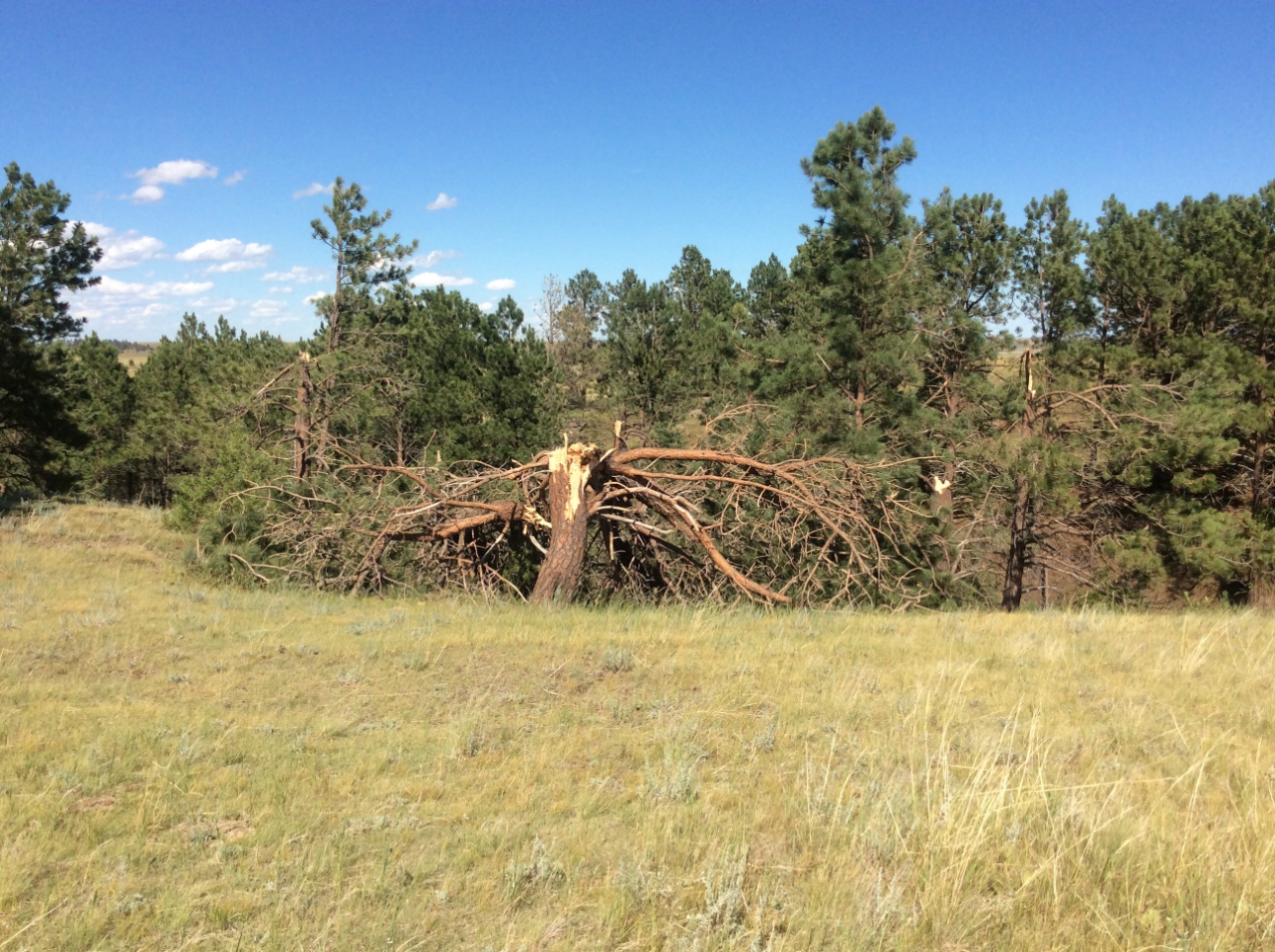 |
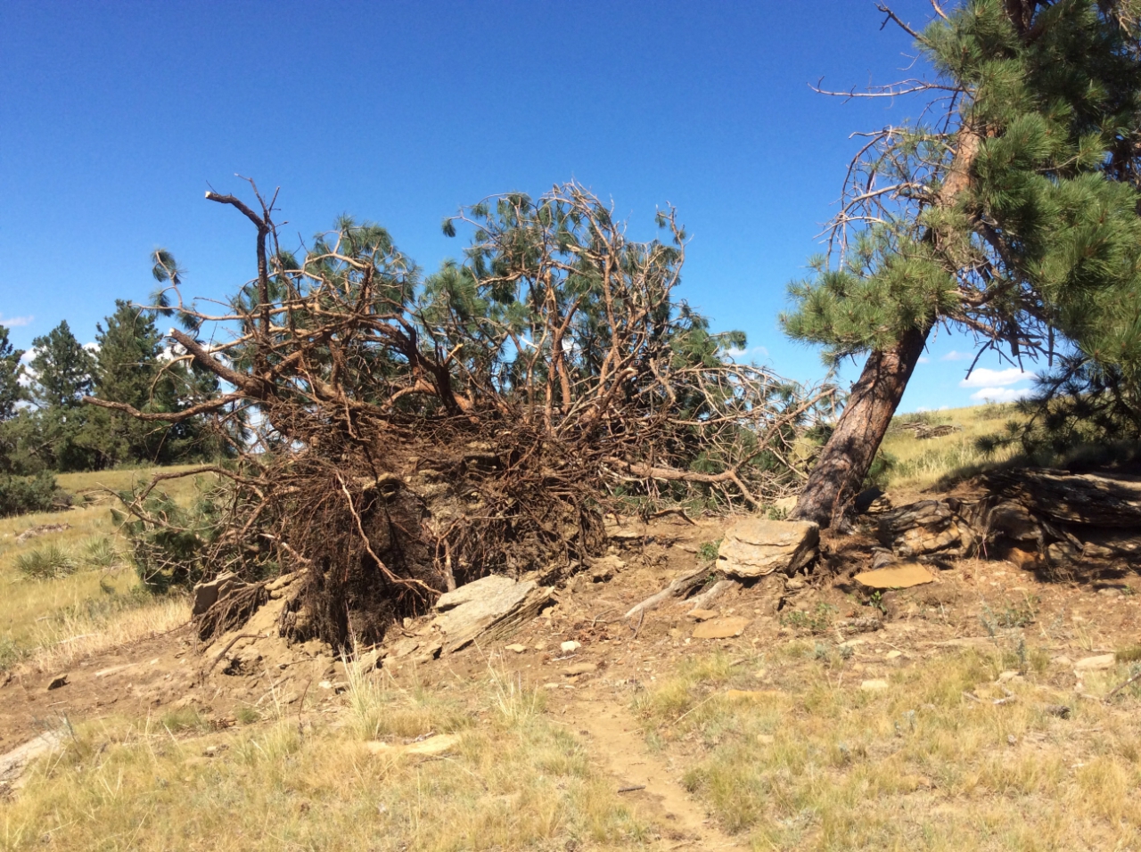
| Trees toppled near Corral Road (NWS) | Trees snapped near Corral Road (NWS) |
The Enhanced Fujita (EF) Scale classifies tornadoes into the following categories:
| EF0 Weak 65-85 mph |
EF1 Moderate 86-110 mph |
EF2 Significant 111-135 mph |
EF3 Severe 136-165 mph |
EF4 Extreme 166-200 mph |
EF5 Catastrophic 200+ mph |
 |
|||||
Wind:
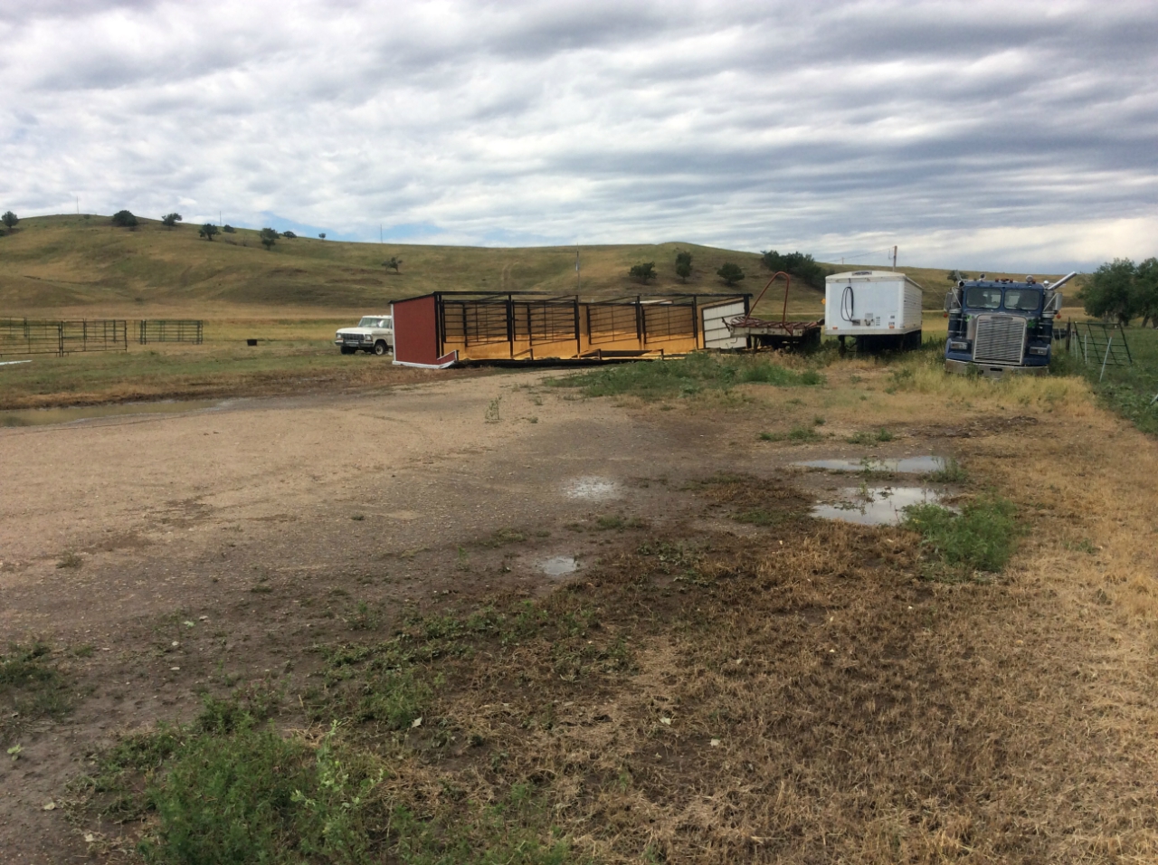
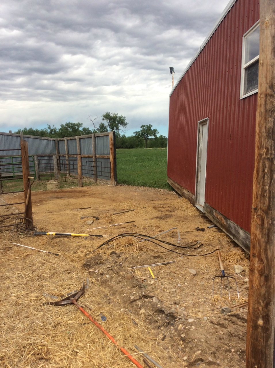
As the storm continued to move eastward, it snapped additional power poles and destroyed a small hunting cabin along Plainview Road south of Plainview, SD. A nearby weather station recorded a 112 mph wind gust. Farther east; it flipped two sheds, pushed another shed about 30 feet across the ground, and snapped large trees at a ranch.
 |
 |
 |
 |
| Part of shed blown over | Second part of shed blown over | Shed pushed along the ground | Snapped power pole and debris from cabin |
 |
|||
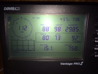
| Weather Station display showing 112 mph wind gust south of Plainview, SD (courtesy of Sioux Spiritual Center) |
Radar:
 |
 |
 |
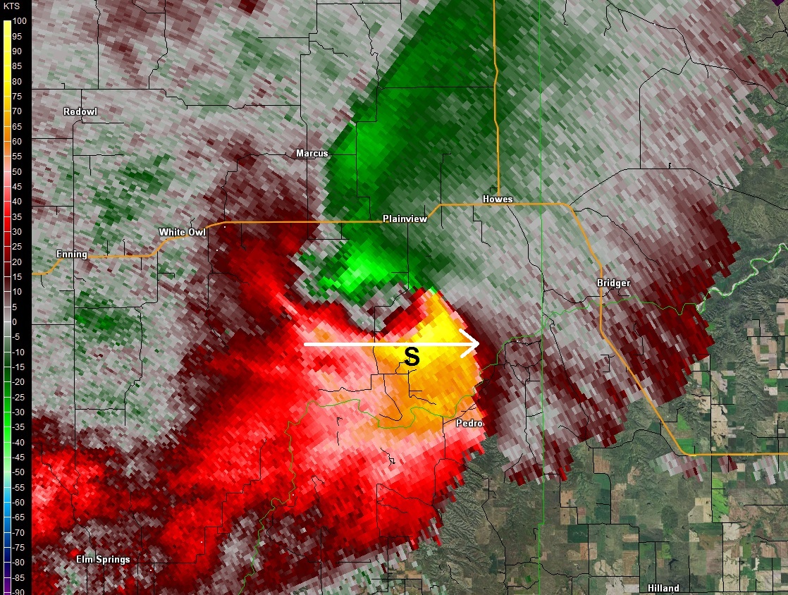 |
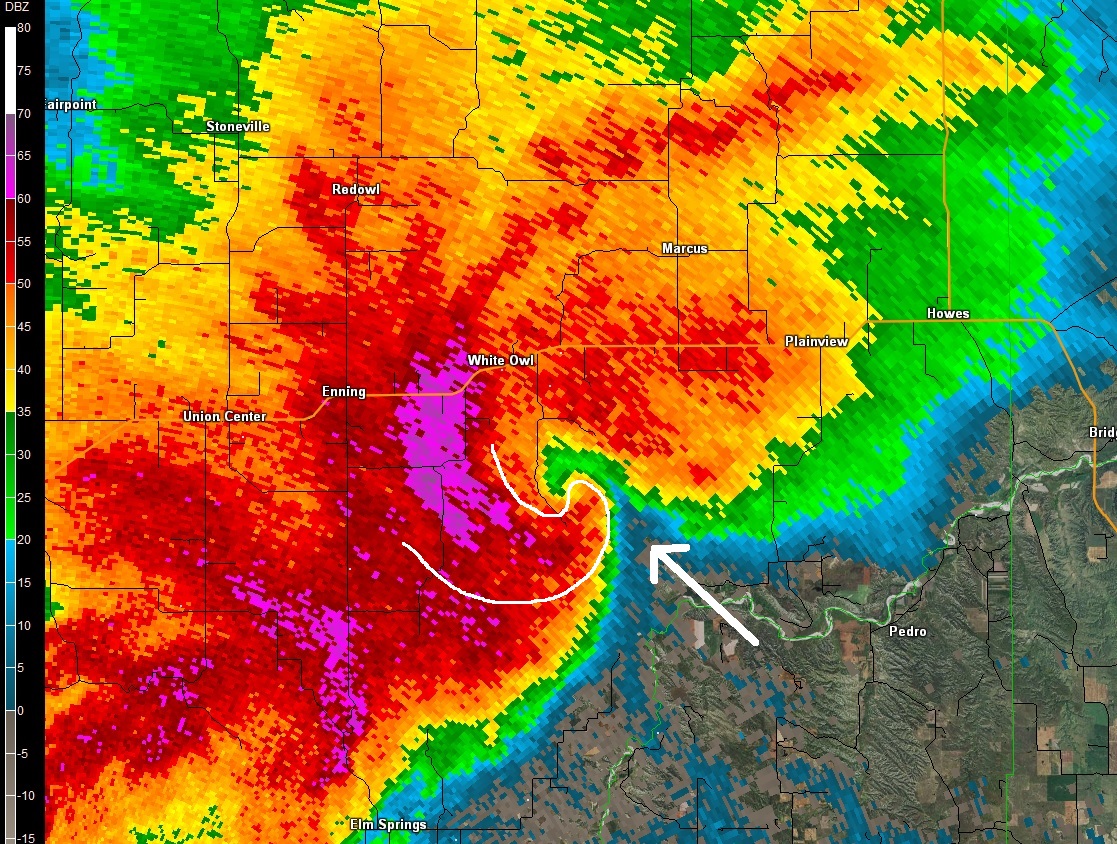
| Nice inflow notch and hook echo quickly developed south of White Owl, SD at 430 PM MDT | Doppler velocity shows a compact circulation 430 PM MDT | A minima of correlation coefficient values near the tip of the hook typically signifies a tornado lofting some debris. The tornado was snapping pine trees at 430 PM MDT. | As the storm moved east, the compact circulation morphed into a large area of 100 knot straight-line winds. The "S" marks where the Davis Weather Station recorded a 112 MPH wind gust at the Sioux Spiritual Center south of Plainview, SD. |
Storm Reports:
PRELIMINARY LOCAL STORM REPORT...SUMMARY
NATIONAL WEATHER SERVICE RAPID CITY SD
935 PM MDT WED JUL 06 2016

..TIME...   ...EVENT...      ...CITY LOCATION...     ...LAT.LON...
..DATE...   ....MAG....      ..COUNTY LOCATION..ST.. ...SOURCE....
            ..REMARKS..

0228 PM     HAIL             SUNDANCE                44.40N 104.38W
07/06/2016  E0.25 INCH       CROOK              WY   TRAINED SPOTTER

0250 PM     HAIL             NEWELL                  44.71N 103.42W
07/06/2016  E1.00 INCH       BUTTE              SD   TRAINED SPOTTER

0250 PM     TSTM WND GST     NEWELL                  44.71N 103.42W
07/06/2016  E60 MPH          BUTTE              SD   TRAINED SPOTTER

0330 PM     TSTM WND GST     2 SSE TILFORD           44.28N 103.42W
07/06/2016  E60 MPH          MEADE              SD   TRAINED SPOTTER

0330 PM     HAIL             2 SSE TILFORD           44.28N 103.42W
07/06/2016  E0.88 INCH       MEADE              SD   TRAINED SPOTTER

0335 PM     TSTM WND GST     12 SSE DOWNTOWN NEWCAST 43.70N 104.13W
07/06/2016  E60 MPH          WESTON             WY   TRAINED SPOTTER

0340 PM     HAIL             TILFORD                 44.30N 103.43W
07/06/2016  E0.75 INCH       MEADE              SD   TRAINED SPOTTER

0410 PM     HAIL             6 WNW LADNER            45.87N 103.85W
07/06/2016  E1.50 INCH       HARDING            SD   PUBLIC

0410 PM     HAIL             ENNING                  44.58N 102.56W
07/06/2016  E2.50 INCH       MEADE              SD   TRAINED SPOTTER

            SEVERAL BROKEN VEHICLE WINDOWS

0410 PM     TSTM WND GST     ENNING                  44.58N 102.56W
07/06/2016  E60 MPH          MEADE              SD   TRAINED SPOTTER

            SEVERAL BROKEN VEHICLE WINDOWS

0415 PM     HAIL             7 NNE ELLSWORTH AFB     44.23N 103.04W
07/06/2016  M1.00 INCH       MEADE              SD   NWS EMPLOYEE

0419 PM     HAIL             2 N BOX ELDER           44.15N 103.07W
07/06/2016  E1.50 INCH       MEADE              SD   PUBLIC

0420 PM     HAIL             2 ENE ELLSWORTH AFB     44.16N 103.06W
07/06/2016  E1.75 INCH       MEADE              SD   NWS EMPLOYEE

0420 PM     TSTM WND GST     8 SSW UNION CENTER      44.45N 102.70W
07/06/2016  E60 MPH          MEADE              SD   TRAINED SPOTTER

0420 PM     HAIL             BOX ELDER               44.12N 103.07W
07/06/2016  E1.75 INCH       PENNINGTON         SD   PUBLIC

0420 PM     HAIL             ENNING                  44.58N 102.56W
07/06/2016  E2.50 INCH       MEADE              SD   PUBLIC

            SHATTERED WINDSHIELD

0420 PM     HAIL             ELLSWORTH AFB           44.15N 103.10W
07/06/2016  E1.75 INCH       MEADE              SD   PUBLIC

0422 PM     HAIL             5 S ENNING              44.50N 102.56W
07/06/2016  E1.25 INCH       MEADE              SD   NWS EMPLOYEE

            HAIL DRIFTS

0423 PM     HAIL             1 S ENNING              44.56N 102.56W
07/06/2016  E3.00 INCH       MEADE              SD   NWS EMPLOYEE

            HAIL ACCUMULATED

0430 PM     TSTM WND GST     4 N ELM SPRINGS         44.37N 102.53W
07/06/2016  E70 MPH          MEADE              SD   NWS EMPLOYEE

0430 PM     HAIL             4 N ELM SPRINGS         44.37N 102.53W
07/06/2016  E0.50 INCH       MEADE              SD   NWS EMPLOYEE

0430 PM     TSTM WND GST     3 E ELM SPRINGS         44.31N 102.47W
07/06/2016  E60 MPH          MEADE              SD   TRAINED SPOTTER

0435 PM     TSTM WND GST     4 NNE ANGOSTURA RESERVO 43.37N 103.39W
07/06/2016  M57 MPH          FALL RIVER         SD   AWOS

0440 PM     TSTM WND GST     5 ESE DOWNTOWN HOT SPRI 43.40N 103.40W
07/06/2016  E60 MPH          FALL RIVER         SD   TRAINED SPOTTER

0450 PM     TSTM WND DMG     19 NNE CREIGHTON        44.50N 102.03W
07/06/2016                   PENNINGTON         SD   TRAINED SPOTTER

            MANY TREE TOPS BROKEN OFF ... SOME 100 YEARS OLD...
            WORST WINDS HE HAD SEEN IN 50 YEARS. DOOR BLOWN OFF THE
            HINGES.

0455 PM     TSTM WND DMG     15 WNW MILESVILLE       44.51N 101.98W
07/06/2016                   HAAKON             SD   PUBLIC

            TREES BROKEN AND UP ROOTED... 2 BARNS DESTROYED... ONE
            BARN MOVED OFF FOUNDATION... PICKUP TRUCK FLIPPED ON ITS
            SIDE

0508 PM     TSTM WND GST     RAPID CITY AIRPORT      44.05N 103.06W
07/06/2016  M56 MPH          PENNINGTON         SD   ASOS

0510 PM     TSTM WND GST     2 SW BRIDGER            44.53N 101.93W
07/06/2016  M68 MPH          ZIEBACH            SD   DEPT OF HIGHWAYS

            AT LEAST 20 MINUTES OF GUSTS GREATER THAN 58 MPH

0515 PM     HAIL             5 NE MILESVILLE         44.52N 101.62W
07/06/2016  E1.00 INCH       HAAKON             SD   TRAINED SPOTTER

            LASTED 30 MINUTES

0515 PM     TSTM WND GST     5 NE MILESVILLE         44.52N 101.62W
07/06/2016  E70 MPH          HAAKON             SD   TRAINED SPOTTER

            LASTED 30 MINUTES

0520 PM     TSTM WND GST     3 NNW SCENIC            43.82N 102.58W
07/06/2016  M69 MPH          PENNINGTON         SD   DEPT OF HIGHWAYS

0539 PM     HAIL             2 SW KIRLEY             44.50N 101.34W
07/06/2016  E0.50 INCH       HAAKON             SD   TRAINED SPOTTER

0539 PM     TSTM WND GST     2 SW KIRLEY             44.50N 101.34W
07/06/2016  E50 MPH          HAAKON             SD   TRAINED SPOTTER

0550 PM     TSTM WND GST     2 S CACTUS FLAT         43.81N 101.89W
07/06/2016  E60 MPH          JACKSON            SD   TRAINED SPOTTER

0600 PM     TSTM WND GST     4 E CACTUS FLAT         43.84N 101.82W
07/06/2016  M66 MPH          JACKSON            SD   DEPT OF HIGHWAYS

0610 PM     TSTM WND GST     4 E CACTUS FLAT         43.84N 101.82W
07/06/2016  M63 MPH          JACKSON            SD   DEPT OF HIGHWAYS

0615 PM     TSTM WND GST     7 N LODGEPOLE           45.91N 102.66W
07/06/2016  E60 MPH          PERKINS            SD   PUBLIC

0640 PM     TSTM WND GST     6 NE OTTUMWA            44.30N 101.25W
07/06/2016  E60 MPH          HAAKON             SD   TRAINED SPOTTER

THE STORM REPORTS LISTED BELOW ARE IN DESCENDING ORDER AND MAY NOT NECESSARILY
BE THE FINAL STORM REPORTS.

HAIL REPORTS LISTED BY SIZE (INCHES)

 SIZE    LOCATION                 ST  COUNTY           TIME
 ------  -----------------------  --  --------------   -------
  3.00   1 S ENNING               SD  MEADE            0423 PM
  2.50   ENNING                   SD  MEADE            0420 PM
  2.50   ENNING                   SD  MEADE            0410 PM
  1.75   ELLSWORTH AFB            SD  MEADE            0420 PM
  1.75   BOX ELDER                SD  PENNINGTON       0420 PM
  1.75   2 ENE ELLSWORTH AFB      SD  MEADE            0420 PM
  1.50   2 N BOX ELDER            SD  MEADE            0419 PM
  1.50   6 WNW LADNER             SD  HARDING          0410 PM
  1.25   5 S ENNING               SD  MEADE            0422 PM
  1.00   5 NE MILESVILLE          SD  HAAKON           0515 PM
  1.00   7 NNE ELLSWORTH AFB      SD  MEADE            0415 PM
  1.00   NEWELL                   SD  BUTTE            0250 PM
  0.88   2 SSE TILFORD            SD  MEADE            0330 PM
  0.75   TILFORD                  SD  MEADE            0340 PM
  0.50   2 SW KIRLEY              SD  HAAKON           0539 PM
  0.50   4 N ELM SPRINGS          SD  MEADE            0430 PM
  0.25   SUNDANCE                 WY  CROOK            0228 PM

TSTM WIND REPORTS LISTED BY SPEED (MPH)

 SPEED   LOCATION                 ST  COUNTY           TIME
 ------  -----------------------  --  --------------   -------
 70.00   5 NE MILESVILLE          SD  HAAKON           0515 PM
 70.00   4 N ELM SPRINGS          SD  MEADE            0430 PM
 69.00   3 NNW SCENIC             SD  PENNINGTON       0520 PM
 68.00   2 SW BRIDGER             SD  ZIEBACH          0510 PM
 66.00   4 E CACTUS FLAT          SD  JACKSON          0600 PM
 63.00   4 E CACTUS FLAT          SD  JACKSON          0610 PM
 60.00   6 NE OTTUMWA             SD  HAAKON           0640 PM
 60.00   7 N LODGEPOLE            SD  PERKINS          0615 PM
 60.00   2 S CACTUS FLAT          SD  JACKSON          0550 PM
 60.00   5 ESE DOWNTOWN HOT SPRI  SD  FALL RIVER       0440 PM
 60.00   3 E ELM SPRINGS          SD  MEADE            0430 PM
 60.00   8 SSW UNION CENTER       SD  MEADE            0420 PM
 60.00   ENNING                   SD  MEADE            0410 PM
 60.00   12 SSE DOWNTOWN NEWCAST  WY  WESTON           0335 PM
 60.00   2 SSE TILFORD            SD  MEADE            0330 PM
 60.00   NEWELL                   SD  BUTTE            0250 PM
 57.00   4 NNE ANGOSTURA RESERVO  SD  FALL RIVER       0435 PM
 56.00   RAPID CITY AIRPORT       SD  PENNINGTON       0508 PM
 50.00   2 SW KIRLEY              SD  HAAKON           0539 PM
 |
Media use of NWS Web News Stories is encouraged! Please acknowledge the NWS as the source of any news information accessed from this site. |
|

