
Flash flooding threatens areas from the Tennessee Valley to the Carolinas as storms repeat along a stalled front. Monsoonal storms may trigger flooding in the Southwest. Dangerous heat expands across the Desert Southwest, Plains, mid-Mississippi Valley and Southern Tier. Critical fire weather for interior Pacific Northwest. Cooler, drier air brings brief relief to the Great Lakes and Northeast. Read More >
Overview
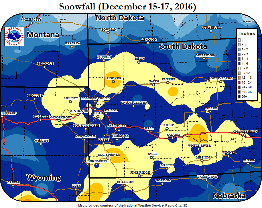
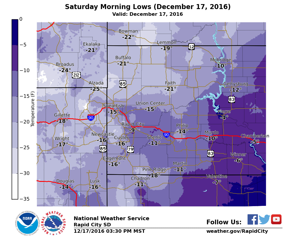
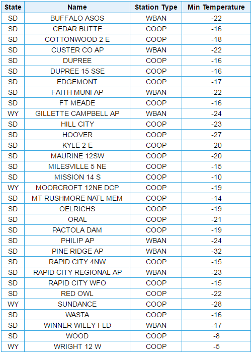
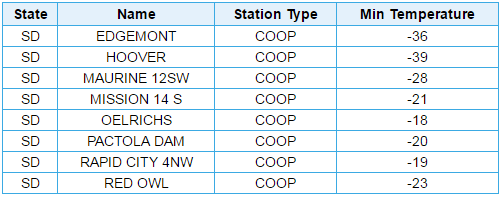
A strong winter storm system moved across the Rockies into the northern Plains December 15-16, 2016. Moisture was lifted over the cold air in place over northeast Wyoming and western South Dakota resulting in widespread snow amounts averaging 4 to 8 inches with locally higher amounts. Bitterly cold arctic air poured in behind the storm with temperatures staying below zero Saturday. Wind chills were dangerously cold with readings 20 below zero to nearly 45 degrees below zero.
 |
 |
 |
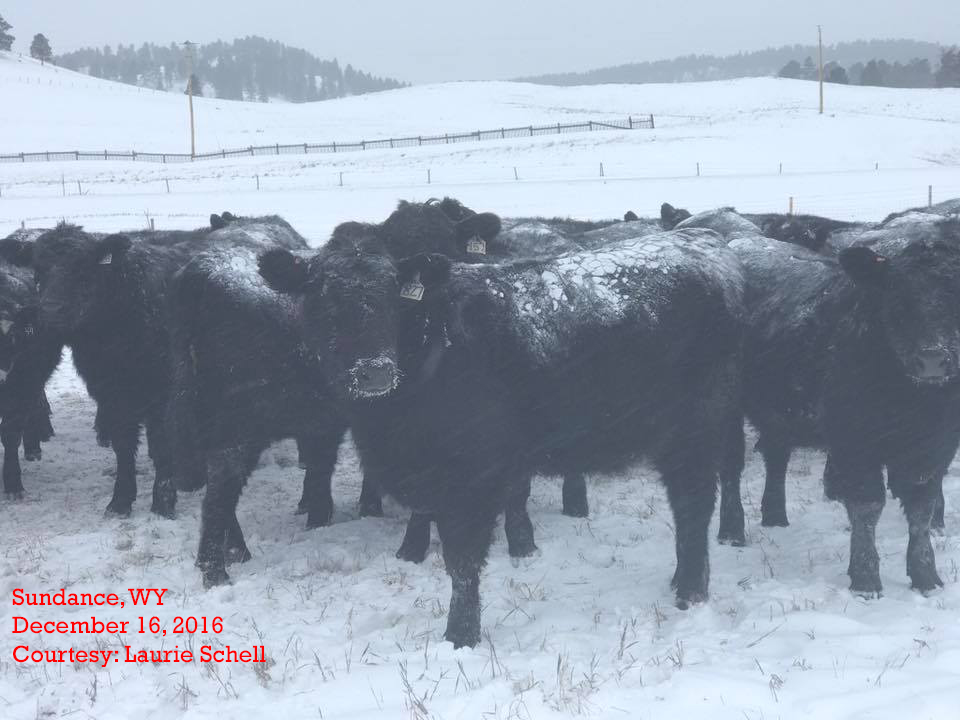 |
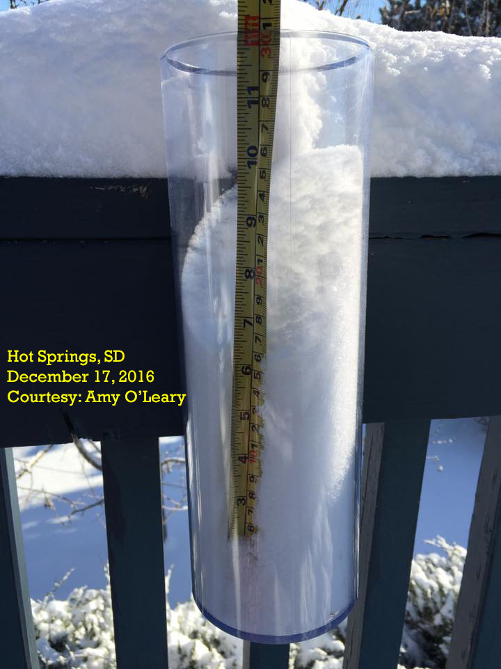
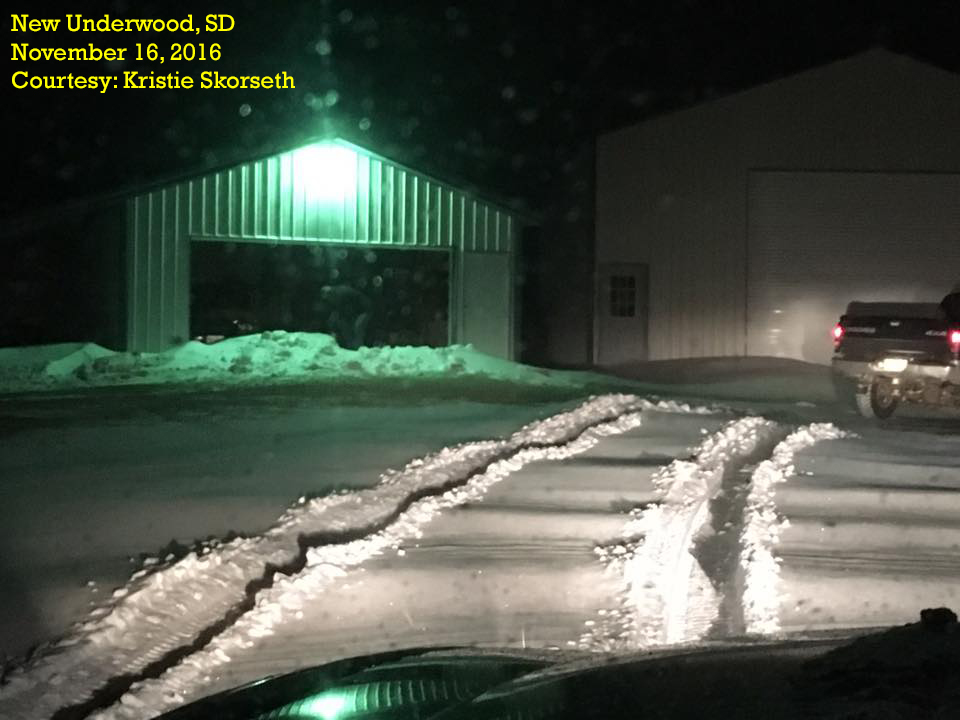
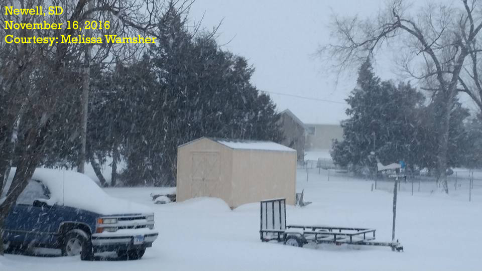
| Hot Springs, SD | New Underwood, SD | Newell, SD | Sundance, WY |
Snow
THE STORM REPORTS LISTED BELOW ARE IN DESCENDING ORDER AND MAY NOT NECESSARILY
BE THE FINAL STORM REPORTS.

SNOW REPORTS LISTED BY AMOUNT

 INCHES  LOCATION                 ST  COUNTY           TIME
 ------  -----------------------  --  --------------   -------
 12.00   BUFFALO GAP              SD  CUSTER           1000 PM
                 3-4 FOOT DRIFTS
 10.00   2 NW BUFFALO GAP         SD  CUSTER           0500 AM
  9.00   HOOVER                   SD  BUTTE            0830 AM
  8.30   1 SSW RAPID VALLEY       SD  PENNINGTON       0838 PM
                 SNOWFALL TOTAL
  8.00   8 W DOWNTOWN SPEARFISH   SD  LAWRENCE         0100 PM
                 SNOWFALL 8 TO 10 INCHES.
  8.00   LEAD                     SD  LAWRENCE         1229 PM
  8.00   5 E PORCUPINE            SD  OGLALA LAKOTA    0822 AM
  8.00   ORAL                     SD  FALL RIVER       0700 AM
  8.00   14 SSW RED SHIRT         SD  OGLALA LAKOTA    0752 PM
                 SNOWFALL TOTAL THUS FAR. DRIFTS OF AT LEAST 2
                 FEET.
  8.00   POTATO CREEK             SD  JACKSON          0738 PM
                 SNOW AMOUNT THUS FAR.
  8.00   PINE HAVEN               WY  CROOK            0700 PM
  8.00   2 NNW SAINT ONGE         SD  LAWRENCE         0700 AM
  7.60   6 NNW EDGEMONT           SD  FALL RIVER       0700 AM
  7.50   3 SE HARDING             SD  HARDING          0800 AM
  7.50   2 ESE MISSION            SD  TODD             0754 PM
                 SNOW AMOUNT SINCE THIS MORNING. 2 FOOT
                 DRIFTS. STILL SNOWING.
  7.50   SUNDANCE                 WY  CROOK            0700 PM
  7.30   OELRICHS                 SD  FALL RIVER       0700 AM
  7.00   2 SSW NORRIS             SD  MELLETTE         0901 AM
  7.00   21 NW FAITH              SD  PERKINS          0845 AM
  7.00   1 SSW DOWNTOWN HOT SPRI  SD  FALL RIVER       0844 AM
  7.00   1 E WESTON               WY  CAMPBELL         0800 AM
                 6-8 INCHES OF SNOW.
  7.00   4 NW DOWNTOWN RAPID CIT  SD  PENNINGTON       0600 AM
  7.00   1 WSW PRAIRIE CITY       SD  PERKINS          0743 PM
                 SNOW AMOUNT SINCE THIS MORNING. 2 TO 3 FOOT
                 DRIFTS. STILL SNOWING.
  7.00   PHILIP                   SD  HAAKON           0736 PM
                 STORM TOTAL THUS FAR.
  6.80   1 NNE SUNDANCE           WY  CROOK            1159 PM
  6.50   7 SSW PLAINVIEW          SD  MEADE            0600 AM
                 SNOWFALL OF 6 TO 7 INCHES.
  6.50   8 SSW FOLSOM             SD  CUSTER           0500 AM
                 SNOWFALL OF 6 TO 7 INCHES.
  6.10   2 SW HAMILL              SD  TRIPP            0903 AM
  6.00   SUNDANCE                 WY  CROOK            0948 AM
                 LOTS OF DRIFTING
  6.00   8 S DOWNTOWN RAPID CITY  SD  PENNINGTON       0938 AM
  6.00   5 NE DOWNTOWN CUSTER     SD  CUSTER           0930 AM
  6.00   6 WNW LITTLEBURG         SD  TODD             0905 AM
  6.00   3 ENE NEWELL             SD  BUTTE            0904 AM
  6.00   2 SSE DEERFIELD          SD  PENNINGTON       0810 AM
  6.00   12 SW MAURINE            SD  MEADE            0700 AM
  6.00   2 E KYLE                 SD  OGLALA LAKOTA    0700 AM
  6.00   5 N SCENIC               SD  PENNINGTON       0600 AM
  6.00   TILFORD                  SD  MEADE            0400 AM
  6.00   12 SSE DOWNTOWN NEWCAST  WY  WESTON           0300 AM
  6.00   4 SE PINE HAVEN          WY  CROOK            0300 AM
  6.00   13 S ROZET               WY  CAMPBELL         0200 AM
  6.00   2 WSW SWETT              SD  BENNETT          0100 AM
  6.00   8 SSE WITTEN             SD  TRIPP            0751 PM
                 SNOW AMOUNT SINCE THIS MORNING. STILL
                 SNOWING.
  6.00   5 E PORCUPINE            SD  OGLALA LAKOTA    0748 PM
                 SNOWFALL SINCE THIS MORNING. HEAVY SNOW STILL
                 FALLING.
  6.00   14 SSE DUPREE            SD  ZIEBACH          0745 PM
                 SNOW AMOUNT SINCE THIS MORNING. 2 TO 3 FOOT
                 DRIFTS. STILL SNOWING.
  6.00   2 WSW SWETT              SD  BENNETT          0743 PM
                 SNOW TOTAL THUS FAR. STILL SNOWING.
  6.00   4 SW NEWELL              SD  BUTTE            0739 PM
                 SNOW AMOUNT SINCE THIS MORNING. ROADS COVERED
                 IN SNOW. STILL SNOWING.
  6.00   9 WSW RED ELM            SD  ZIEBACH          0732 PM
                 SNOW AMOUNT SINCE THIS MORNING. 2 FOOT
                 DRIFTS. ROADS COVERED IN SNOW. STILL SNOWING.
  6.00   2 SE COLONY              WY  CROOK            0728 PM
                 SNOW AMOUNT SINCE THIS MORNING. 2 FOOT
                 DRIFTS. STILL SNOWING.
  6.00   4 ENE DATE               SD  PERKINS          0725 PM
                 STORM TOTAL THUS FAR. LIGHT SNOW STILL
                 FALLING.
  6.00   8 NW ROCKYPOINT          WY  CAMPBELL         0722 PM
                 SNOW AMOUNT SINCE THIS MORNING. 3 FOOT
                 DRIFTS. STILL SNOWING.
  6.00   BUFFALO                  SD  HARDING          0717 PM
                 STORM TOTAL THUS FAR. WIND CAUSING HIGH
                 DRIFTS.
  6.00   2 WNW DOWNTOWN GILLETTE  WY  CAMPBELL         0713 PM
                 SNOW AMOUNT SINCE THIS MORNING. 2 1/2 FOOT
                 DRIFTS. STILL SNOWING.
  6.00   NEWELL                   SD  BUTTE            0600 PM
                 STORM TOTAL... STILL SNOWING.
  6.00   4 W DOWNTOWN CUSTER      SD  CUSTER           0525 PM
  6.00   DUPREE                   SD  ZIEBACH          0450 PM
  6.00   DOWNTOWN HOT SPRINGS     SD  FALL RIVER       0400 PM
  5.50   20 ENE MARTIN            SD  BENNETT          0846 AM
  5.50   4 NNW WHITEWOOD          SD  LAWRENCE         0845 AM
  5.10   1 E DOWNTOWN RAPID CITY  SD  PENNINGTON       0850 AM
  5.00   8 S PLAINVIEW            SD  MEADE            0700 AM
                 STORM TOTAL ACCUMULATION
  5.00   HILL CITY                SD  PENNINGTON       0700 AM
  5.00   5 WNW HERMOSA            SD  CUSTER           0600 AM
  5.00   5 ESE ELM SPRINGS        SD  MEADE            0600 AM
  5.00   ENNING                   SD  MEADE            0500 AM
                 SNOWFALL 4 TO 5 INCHES.
  5.00   UPTON                    WY  WESTON           0300 AM
  5.00   3 W WHITE RIVER          SD  MELLETTE         0756 PM
                 SNOW AMOUNT SINCE THIS MORNING.
  5.00   6 NE OTTUMWA             SD  HAAKON           0733 PM
                 STORM TOTAL THUS FAR. STILL SNOWING WITH
                 BLOWING SNOW.
  5.00   1 E BRIDGER              SD  ZIEBACH          0730 PM
                 STORM TOTAL THUS FAR. STILL SNOWING.
  5.00   HILL CITY                SD  PENNINGTON       0615 PM
  4.70   14 NNW DOWNTOWN GILLETT  WY  CAMPBELL         0843 AM
  4.50   2 SSE DOWNTOWN RAPID CI  SD  PENNINGTON       1031 AM
  4.50   5 E PIEDMONT             SD  MEADE            0847 AM
  4.50   1 E CLARETON             WY  WESTON           0734 PM
                 SNOW AMOUNT SINCE THIS MORNING.
  4.30   5 SW DOWNTOWN RAPID CIT  SD  PENNINGTON       0848 AM
  4.20   DOWNTOWN SPEARFISH       SD  LAWRENCE         0848 AM
  4.00   7 W DOWNTOWN RAPID CITY  SD  PENNINGTON       0909 AM
  4.00   13 SSW DOWNTOWN NEWCAST  WY  WESTON           0844 AM
  4.00   WASTA                    SD  PENNINGTON       0800 AM
  4.00   PACTOLA RESERVOIR        SD  PENNINGTON       0700 AM
  4.00   1 SSW RENO JUNCTION      WY  CAMPBELL         0912 PM
                 SNOWFALL TOTAL. DRIFTS OF AT LEAST 2 FEET.
  4.00   2 E DOWNTOWN STURGIS     SD  MEADE            0400 PM
  3.90   RAPID CITY AIRPORT       SD  PENNINGTON       0851 AM
  3.50   10 WNW DOWNTOWN RAPID C  SD  PENNINGTON       0910 AM
  3.50   7 SSW CREIGHTON          SD  PENNINGTON       0748 PM
                 SNOW AMOUNT SINCE THIS MORNING. STILL
                 SNOWING.
  3.00   8 WSW LADNER             SD  HARDING          0736 PM
                 SNOW AMOUNT SINCE THIS MORNING.
  3.00   14 WNW LADNER            SD  HARDING          0721 PM
                 STORM TOTAL. NO LONGER SNOWING. LOWEST
                 VISIBILITY AROUND 1/2 MI AROUND NOON.
  3.00   LEMMON                   SD  PERKINS          0500 PM
  2.50   6 NNE DOWNTOWN RAPID CI  SD  MEADE            0849 AM
  2.00   10 WNW PINE TREE JUNCTI  WY  CAMPBELL         0720 PM
                 SNOW AMOUNT SINCE THIS MORNING.
Records
.png)
Radar and Satellite
 |
 |
 |
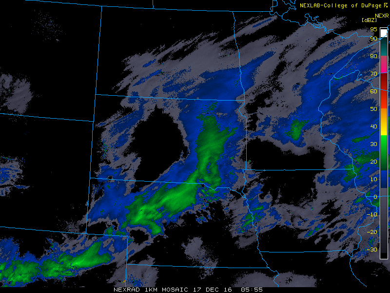 |
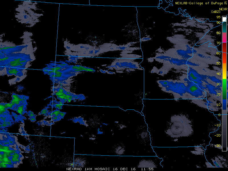
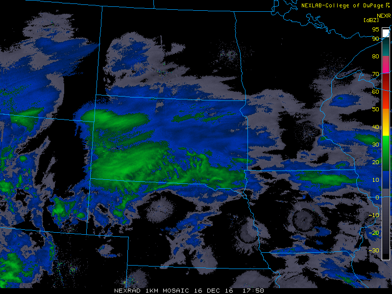
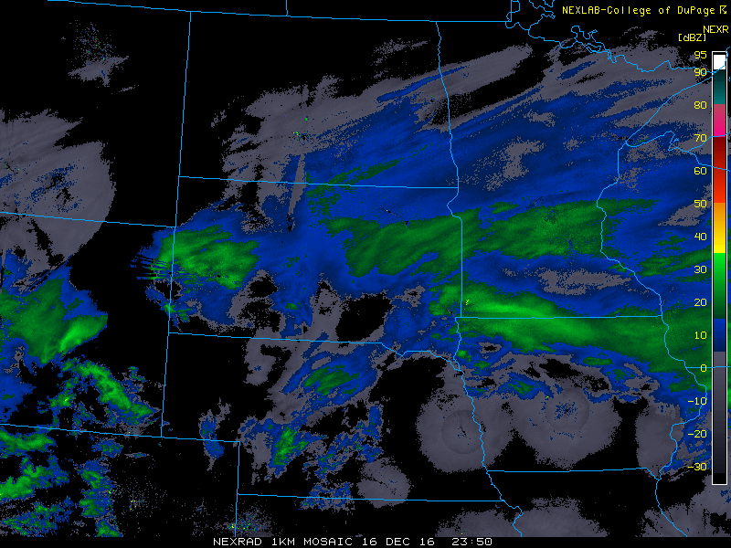
| Regional Radar December 16, 2016 at 500 AM MST | Regional Radar December 16, 2016 at 1100 AM MST | Regional Radar December 16, 2016 at 500 PM MST | Regional Radar December 16, 2016 at 1100 PM MST |
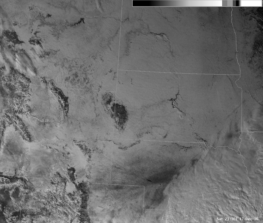 |
| 1km Visible Satellite Image at 230 PM MST December 17, 2016 Showing Widespread Snow Cover |
Temperatures and Wind Chills
 |
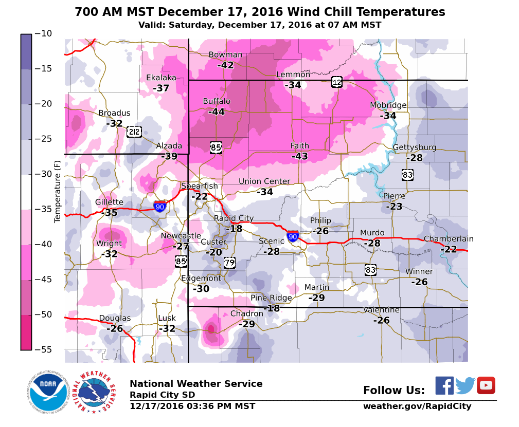 |
| Low Temperatures Saturday Morning December 17, 2016 | 700 AM MST December 17, 2016 Wind Chill Temperatures |
.png) |
.png) |
| Low Temperature Sunday Morning December 18, 2016 | 900 PM MST December 17, 2016 Wind Chill Temperatures |
 |
Media use of NWS Web News Stories is encouraged! Please acknowledge the NWS as the source of any news information accessed from this site. |
|

