A heat wave over the Southwest will intensify this week, peaking and expanding into the Intermountain West and northern High Plains this weekend. Critical to extremely critical fire weather conditions are forecast from the Northwest and the northern Great Basin this weekend. Particularly Dangerous Situation Red Flag Warnings have been issued. Read More >
Overview
|
On February 6th and 7th, several rounds of light snow led to minor to moderate snowfall accumulations to northeastern Wyoming and western South Dakota, with highest amounts west of the Black Hills and over the South Dakota plains from eastern Meade through southern Ziebach Counties. Strong winds during and after the snow led to blowing and drifting while contributing to dangerously cold conditions that extended into February 8th.
|
|
Snowfall Totals
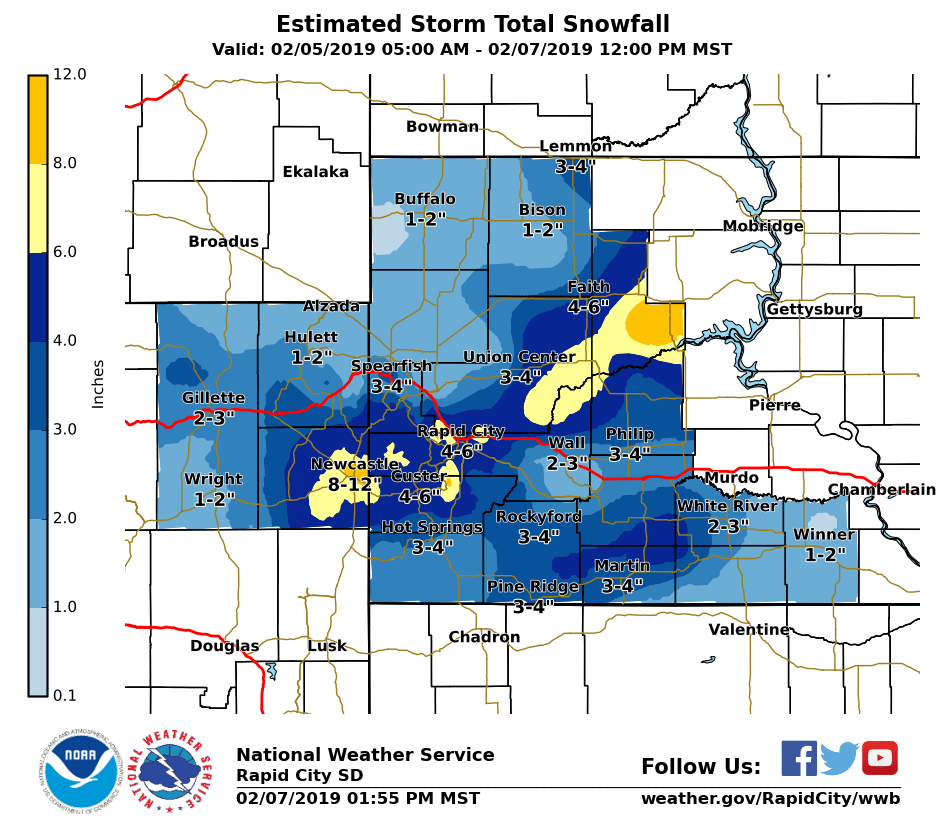
SNOW REPORTS LISTED BY AMOUNT

 INCHES  LOCATION                 ST  COUNTY           TIME
 ------  -----------------------  --  --------------   -------
 11.30   14 SSE DUPREE            SD  ZIEBACH          0800 AM
 11.00   DOWNTOWN NEWCASTLE       WY  WESTON           0300 PM
 10.50   3 E DOWNTOWN NEWCASTLE   WY  WESTON           0600 AM
  8.00   1 NE JOHNSON SIDING      SD  PENNINGTON       1025 AM
  8.00   6 ESE CLARETON           WY  WESTON           0453 PM
  8.00   DOWNTOWN NEWCASTLE       WY  WESTON           0600 AM
  7.80   4 SW SUMMERSET           SD  MEADE            0400 PM
  7.50   5 ESE ELM SPRINGS        SD  MEADE            0108 PM
  7.00   16 WNW MILESVILLE        SD  HAAKON           0110 PM
  7.00   15 ENE CHERRY CREEK      SD  ZIEBACH          1128 AM
  7.00   BOX ELDER                SD  PENNINGTON       0857 AM
  7.00   4 SE DEERFIELD           SD  PENNINGTON       0952 AM
  6.80   1 WNW DUPREE             SD  ZIEBACH          1058 AM
  6.70   3 NNE JOHNSON SIDING     SD  PENNINGTON       0700 AM
  6.50   7 W HERMOSA              SD  CUSTER           1024 AM
  6.00   5 WSW HERMOSA            SD  CUSTER           0907 AM
  6.00   1 WNW CLARETON           WY  WESTON           0700 AM
  6.00   4 NW DOWNTOWN RAPID CIT  SD  PENNINGTON       0600 AM
  5.60   1 ESE PACTOLA RESERVOIR  SD  PENNINGTON       0715 AM
  5.50   2 SW NORRIS              SD  MELLETTE         0800 AM
  5.00   8 NW HILL CITY           SD  PENNINGTON       0841 AM
  5.00   3 W RAPID CITY AIRPORT   SD  PENNINGTON       0831 AM
  5.00   7 NNE ELLSWORTH AFB      SD  MEADE            0800 AM
  5.00   10 E DOWNTOWN CUSTER     SD  CUSTER           0730 AM
  5.00   4 W DOWNTOWN RAPID CITY  SD  PENNINGTON       0700 AM
  5.00   DOWNTOWN RAPID CITY      SD  PENNINGTON       0700 AM
  5.00   4 NNE SUMMERSET          SD  MEADE            0700 AM
  5.00   RED OWL                  SD  MEADE            0700 AM
  5.00   9 WSW RED ELM            SD  ZIEBACH          0500 PM
  4.70   1 E DOWNTOWN RAPID CITY  SD  PENNINGTON       1100 AM
  4.70   1 SSE DOWNTOWN SPEARFIS  SD  LAWRENCE         0800 AM
  4.70   2 S DOWNTOWN RAPID CITY  SD  PENNINGTON       0700 AM
  4.70   1 NE DOWNTOWN RAPID CIT  SD  PENNINGTON       0600 AM
  4.60   2 WNW DOWNTOWN RAPID CI  SD  PENNINGTON       0700 AM
  4.60   3 ESE CHEYENNE CROSSING  SD  LAWRENCE         0700 AM
  4.50   1 NNW DOWNTOWN SPEARFIS  SD  LAWRENCE         1030 AM
  4.50   5 ENE DOWNTOWN CUSTER    SD  CUSTER           0731 PM
  4.00   5 NE MILESVILLE          SD  HAAKON           0113 PM
  4.00   16 NW PHILIP             SD  HAAKON           1120 AM
  4.00   3 SW DOWNTOWN RAPID CIT  SD  PENNINGTON       1030 AM
  4.00   DOWNTOWN CUSTER          SD  CUSTER           0958 AM
  4.00   1 NW HILL CITY           SD  PENNINGTON       0909 AM
  4.00   3 NE HISEGA              SD  PENNINGTON       0800 AM
  4.00   4 S DOWNTOWN RAPID CITY  SD  PENNINGTON       0800 AM
  4.00   14 NNE MARTIN            SD  BENNETT          0700 AM
  4.00   HILL CITY                SD  PENNINGTON       0700 AM
  4.00   3 ENE KYLE               SD  OGLALA LAKOTA    0700 AM
  4.00   PORCUPINE                SD  OGLALA LAKOTA    0700 AM
  4.00   4 S HILL CITY            SD  PENNINGTON       0620 AM
  4.00   4 NW DOWNTOWN RAPID CIT  SD  PENNINGTON       0600 AM
  3.80   5 ESE NORRIS             SD  MELLETTE         0910 AM
  3.80   1 N HISEGA               SD  PENNINGTON       0700 AM
  3.80   1 ESE PACTOLA RESERVOIR  SD  PENNINGTON       0700 AM
  3.50   PINE HAVEN               WY  CROOK            0834 AM
  3.50   5 NE ROCKERVILLE         SD  PENNINGTON       0700 AM
  3.50   4 NNE SUMMERSET          SD  MEADE            0700 AM
  3.20   DOWNTOWN HOT SPRINGS     SD  FALL RIVER       0700 AM
  3.20   HERMOSA                  SD  CUSTER           0600 AM
  3.20   1 NNE EDGEMONT           SD  FALL RIVER       0600 AM
  3.10   DOWNTOWN HOT SPRINGS     SD  FALL RIVER       0700 AM
  3.00   MIDLAND                  SD  HAAKON           1151 AM
  3.00   8 SE INTERIOR            SD  JACKSON          1125 AM
  3.00   4 W DOWNTOWN HOT SPRING  SD  FALL RIVER       0700 AM
  3.00   6 WNW SHADEHILL          SD  PERKINS          0700 AM
  3.00   1 WNW WIND CAVE VISITOR  SD  CUSTER           0100 PM
  3.00   4 S DOWNTOWN RAPID CITY  SD  PENNINGTON       1230 PM
  2.80   KADOKA                   SD  JACKSON          0700 AM
  2.60   SUNDANCE                 WY  CROOK            0600 AM
  2.50   8 S SAVAGETON            WY  CAMPBELL         1218 PM
  2.50   ORAL                     SD  FALL RIVER       0700 AM
  2.50   14 NNW DOWNTOWN GILLETT  WY  CAMPBELL         0700 AM
  2.50   WASTA                    SD  PENNINGTON       0800 AM
  2.50   1 NE DOWNTOWN RAPID CIT  SD  PENNINGTON       0700 AM
  2.30   3 ESE DEVILS TOWER       WY  CROOK            0600 AM
  2.00   1 WNW HOOVER             SD  BUTTE            1130 AM
  2.00   EDGEMONT                 SD  FALL RIVER       0700 AM
  2.00   6 SSW FAIRPOINT          SD  MEADE            0700 AM
  2.00   8 WNW USTA               SD  PERKINS          0700 AM
  2.00   6 NNW DOWNTOWN SPEARFIS  SD  LAWRENCE         0700 AM
  2.00   LEAD                     SD  LAWRENCE         0200 PM
  2.00   HERMOSA                  SD  CUSTER           0700 AM
  2.00   HILL CITY                SD  PENNINGTON       0700 AM
  1.90   7 N WOOD                 SD  MELLETTE         0700 AM
  1.80   7 NE SMITHWICK           SD  FALL RIVER       1153 AM
  1.70   DOWNTOWN HOT SPRINGS     SD  FALL RIVER       0400 PM
  1.70   1 NNE EDGEMONT           SD  FALL RIVER       0630 AM
  1.50   2 N ANGOSTURA RESERVOIR  SD  FALL RIVER       0902 AM
  1.50   3 SE DOWNTOWN SPEARFISH  SD  LAWRENCE         0852 AM
  1.50   8 WSW LODGEPOLE          SD  PERKINS          0850 AM
  1.50   16 SSE MISSION           SD  TODD             0700 AM
  1.50   1 S DOWNTOWN BELLE FOUR  SD  BUTTE            0700 AM
  1.50   ORAL                     SD  FALL RIVER       0700 AM
  1.50   DOWNTOWN HOT SPRINGS     SD  FALL RIVER       0700 AM
  1.50   4 S DOWNTOWN RAPID CITY  SD  PENNINGTON       0700 AM
  1.30   11 NNE WESTON            WY  CAMPBELL         0700 AM
  1.00   2 W IDEAL                SD  TRIPP            1140 AM
  1.00   12 S QUINN               SD  PENNINGTON       0800 AM
  1.00   6 SW BEULAH              WY  CROOK            0800 AM
  1.00   3 SSE HARDING            SD  HARDING          0800 AM
  1.00   7 E LAKEVIEW             SD  TODD             0700 AM
  1.00   2 E DOWNTOWN STURGIS     SD  MEADE            0600 PM
  1.00   4 SE DOWNTOWN GILLETTE   WY  CAMPBELL         0430 PM
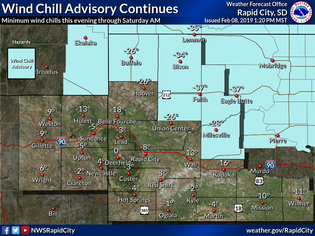
Cold Temperatures
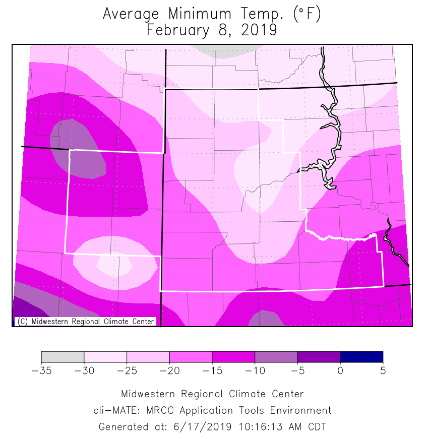
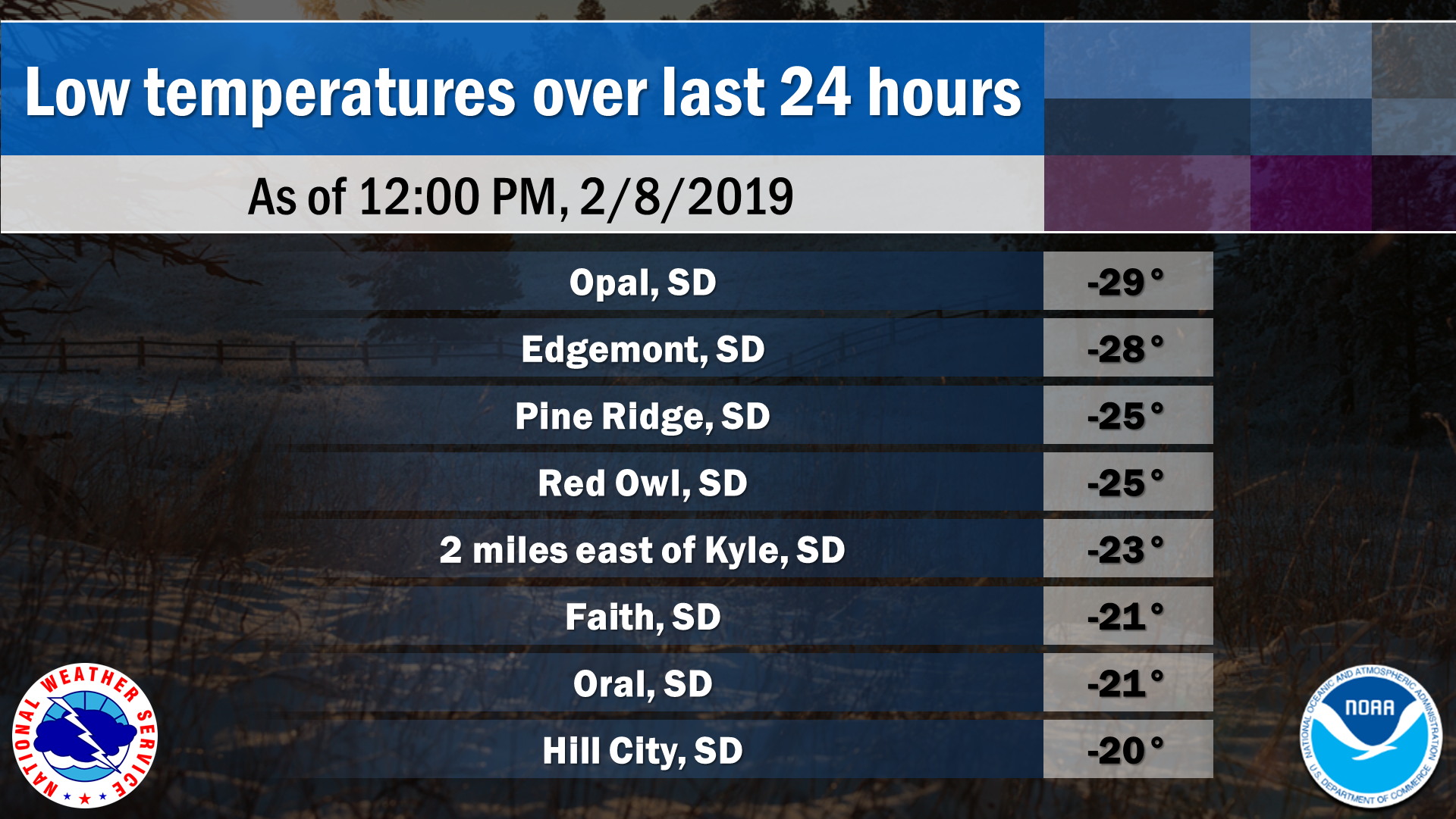
Coldest temperatures from the night of 2/7/19 through the morning of 2/8/19 our official observation sites
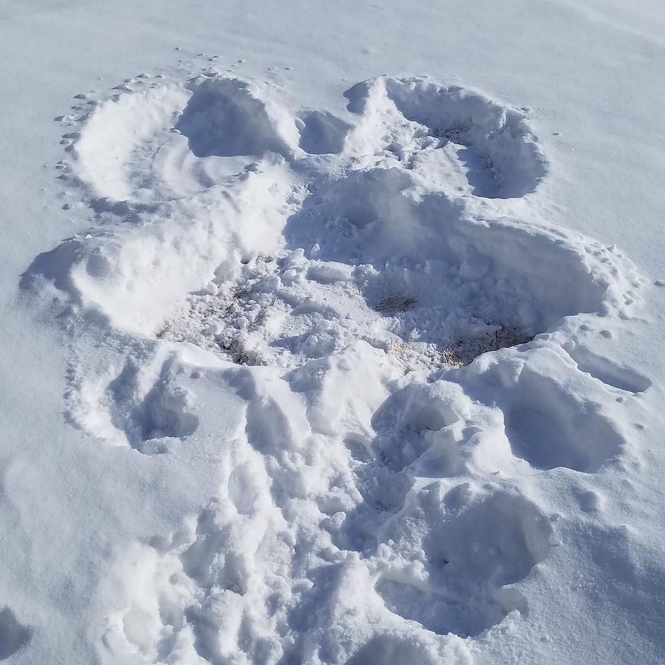
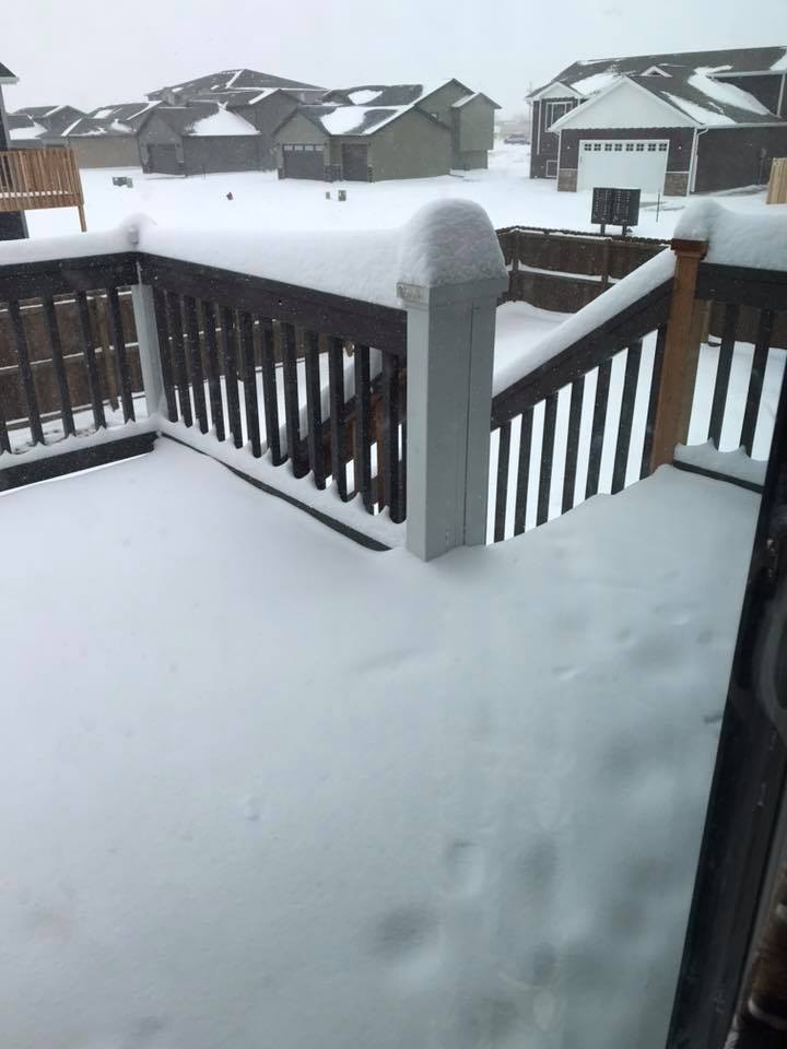
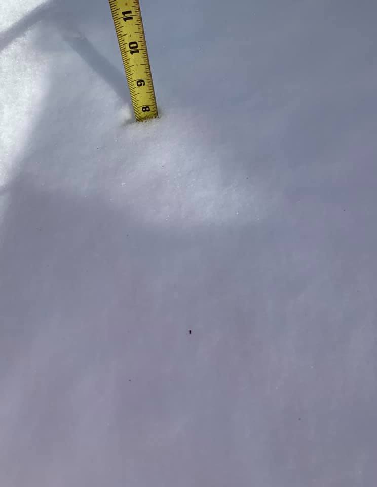
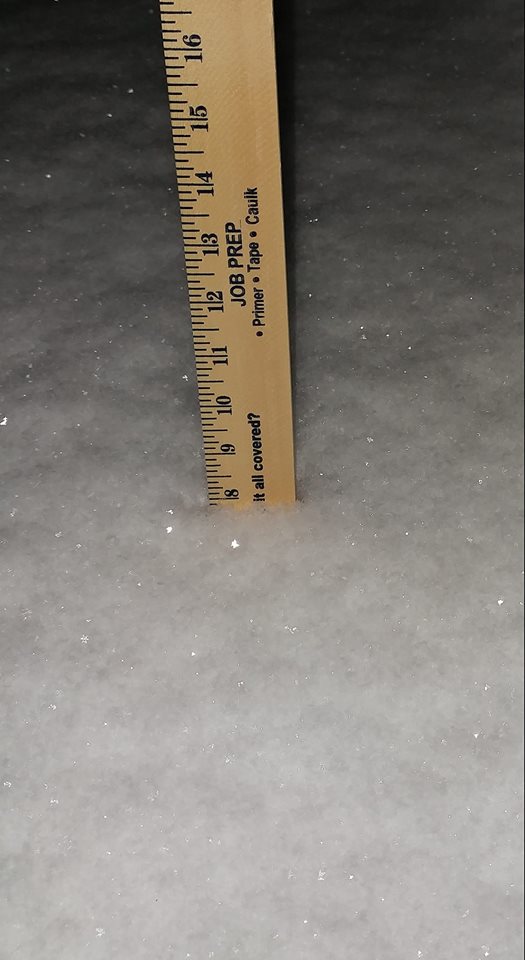
Snow Photos
 |
 |
 |
 |
| Box Elder, SD (courtesy Crystal B.) |
Nemo, SD (courtesy Mercedes K.) |
Newcastle, WY (courtesy Patty F.-C.) |
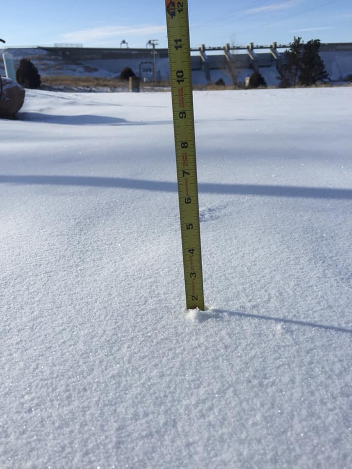
Angostura Dam, SD (courtesy R.J. W.) |
 |
 |
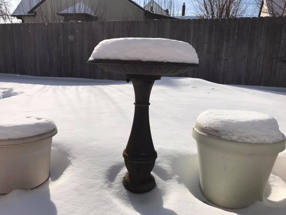
| Rapid City, SD (courtesy Sumasta N.) |
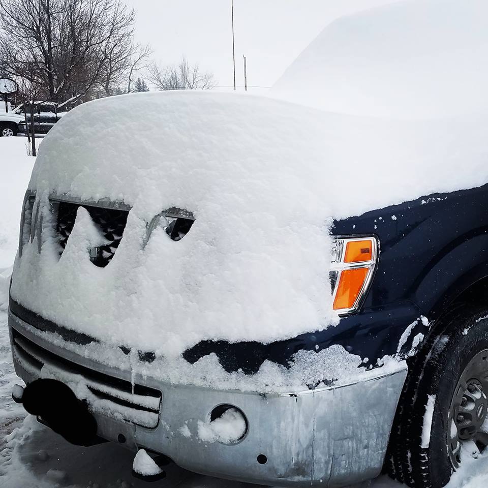
Black Hawk, SD (courtesy Zephi P.) |
 |
Media use of NWS Web News Stories is encouraged! Please acknowledge the NWS as the source of any news information accessed from this site. |
|