
Wildfire smoke will push into the Midwest, worsening air quality. A frontal system brings severe storms from the Northern Plains to the Mid‑Atlantic the next few days. Heavy Gulf Coast rain is possible as Tropical Depression Two has formed, while monsoonal storms persist in the Southwest with heavy rainfall. Hazardous heat expands from the Plains into the Lower Mississippi Valley. Read More >
Overview
|
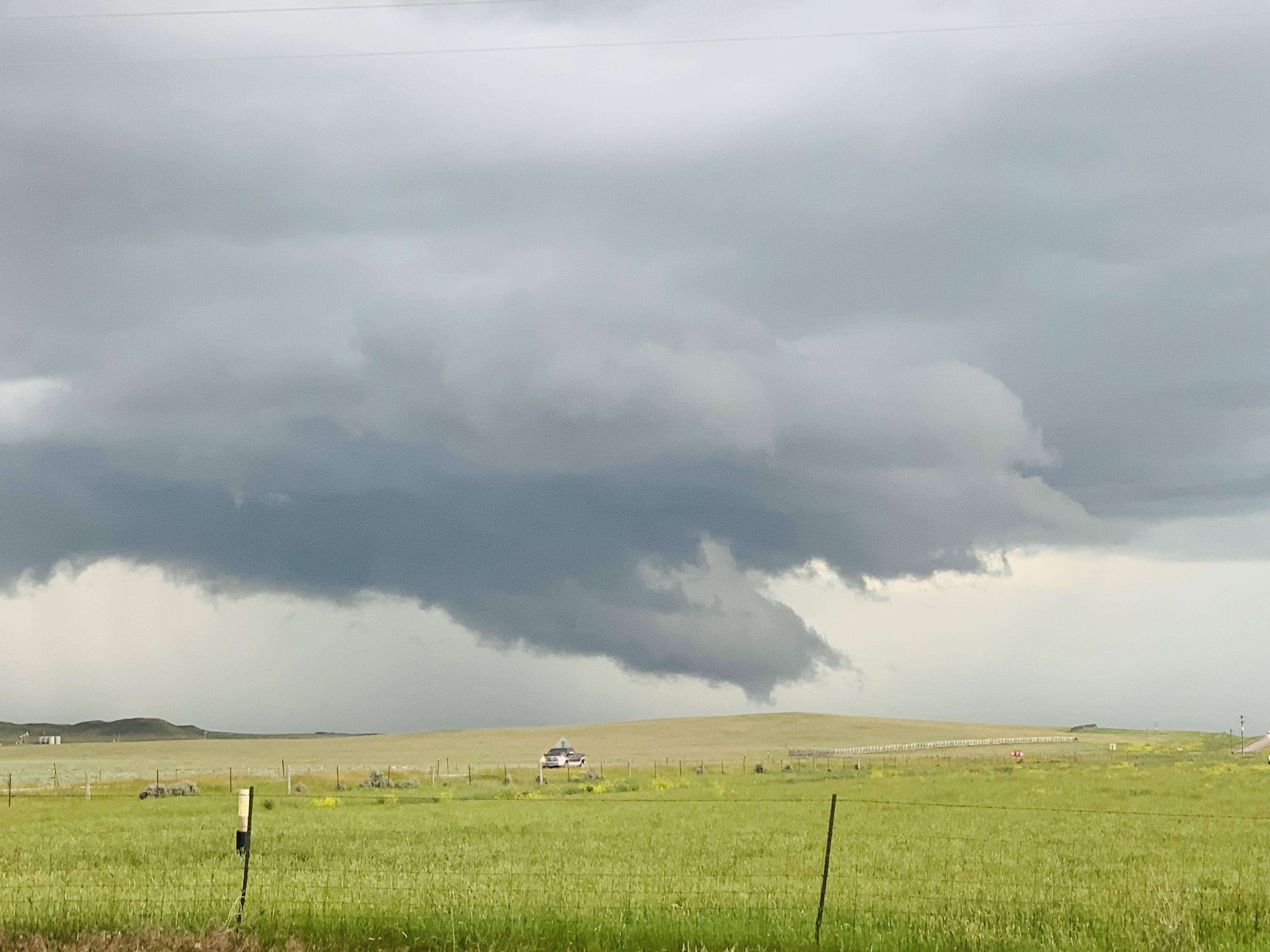
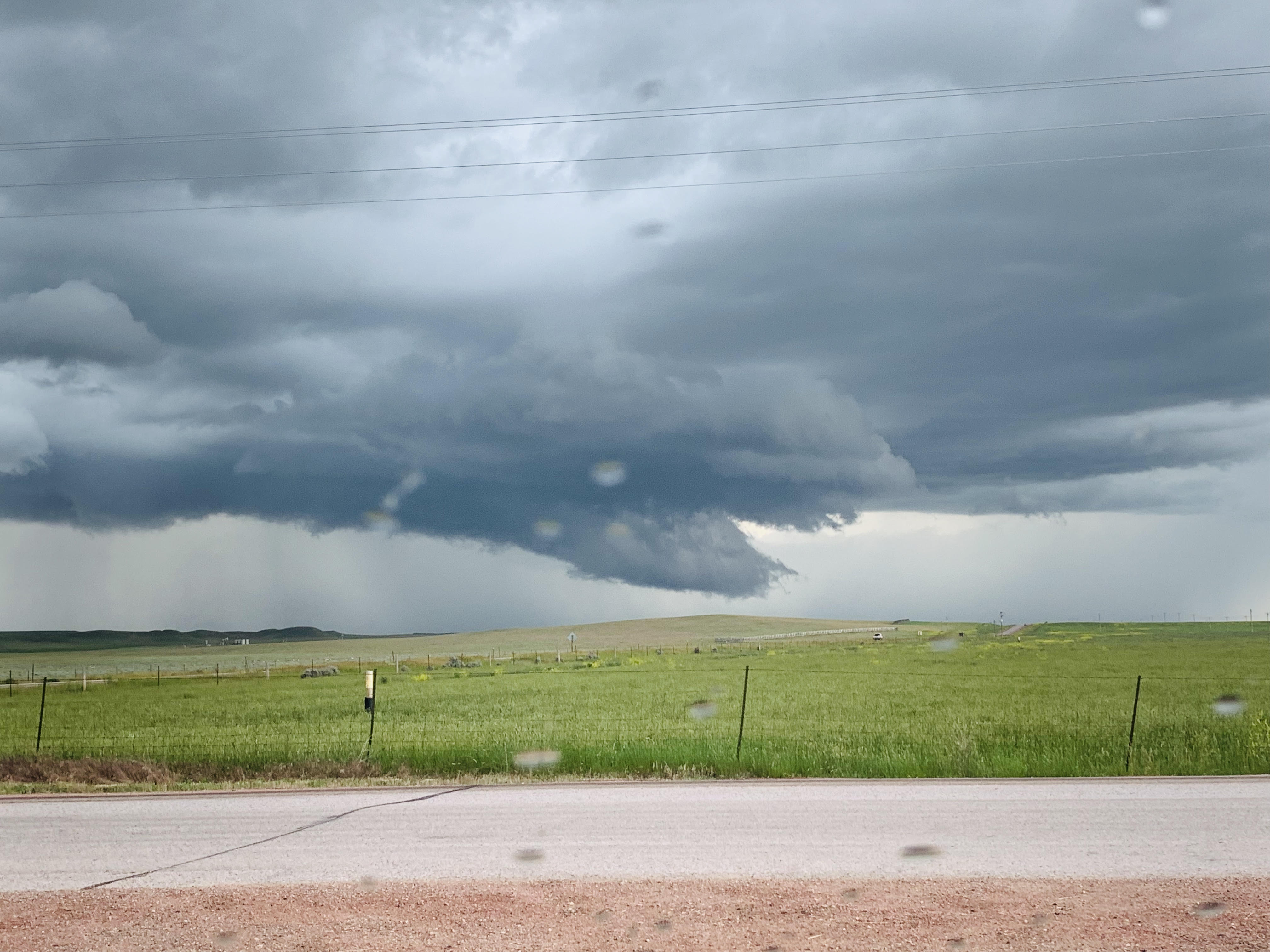
Severe storms with heavy rain, flash flooding, large hail, tornadoes, and damaging straight-line winds moved across northeastern Wyoming and western South Dakota during the afternoon and evening of July 4, 2019. Three short-lived tornadoes occurred in the higher Black Hills (one south of Black Fox Campground, one east of Deerfield Lake, and another northwest of Jewel Cave; damage surveys were done on July 26th and August 2nd to confirm). Otherwise, considerable damage was reported because of flooding and the straight-line winds. Fireworks shows also were cancelled or postponed because of Mother Nature's natural fireworks display. The lightning map to the right shows that there were a lot of cloud-to-ground lightning flashes across the Black Hills area. |
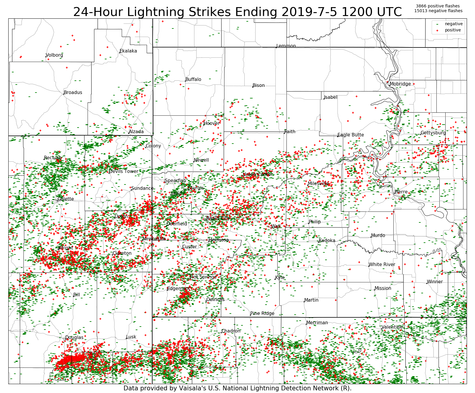 24-hour cloud-to-ground lightning from 6 am July 4 to 6 am July 5, 2019 |
Tornadoes:
|
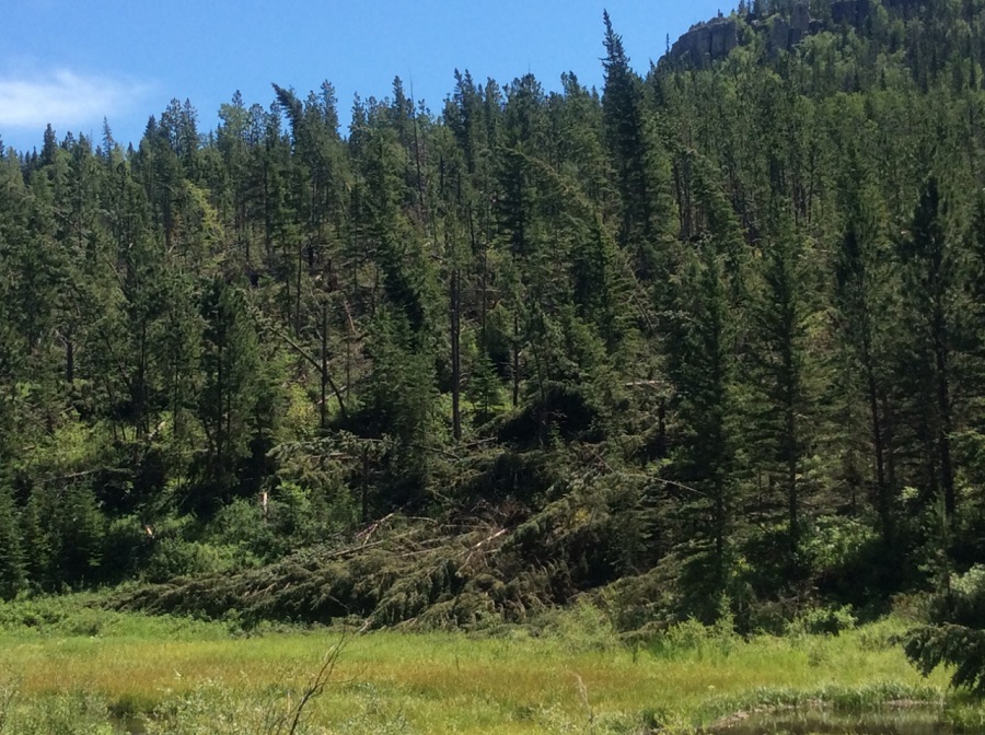
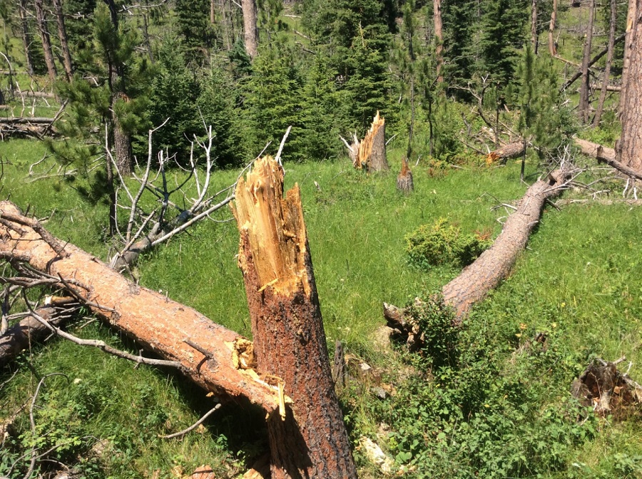
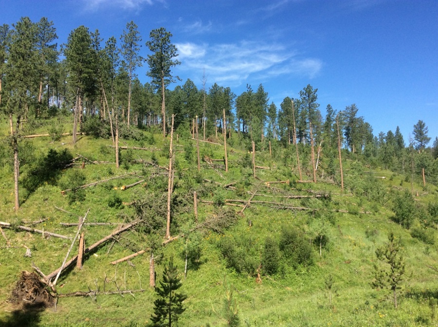
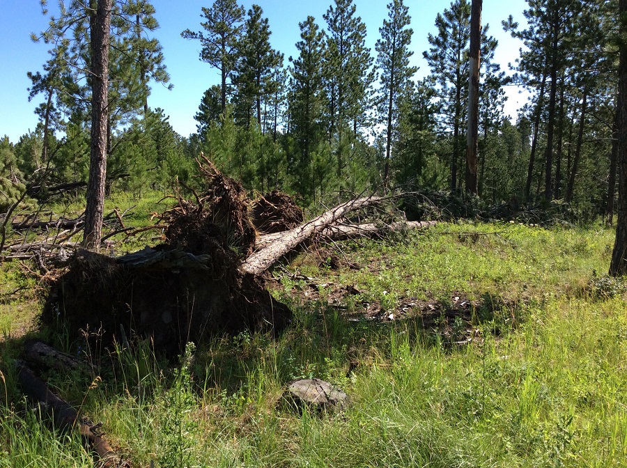
Tornado - 10 mi NNW Jewell Cave
Track Map 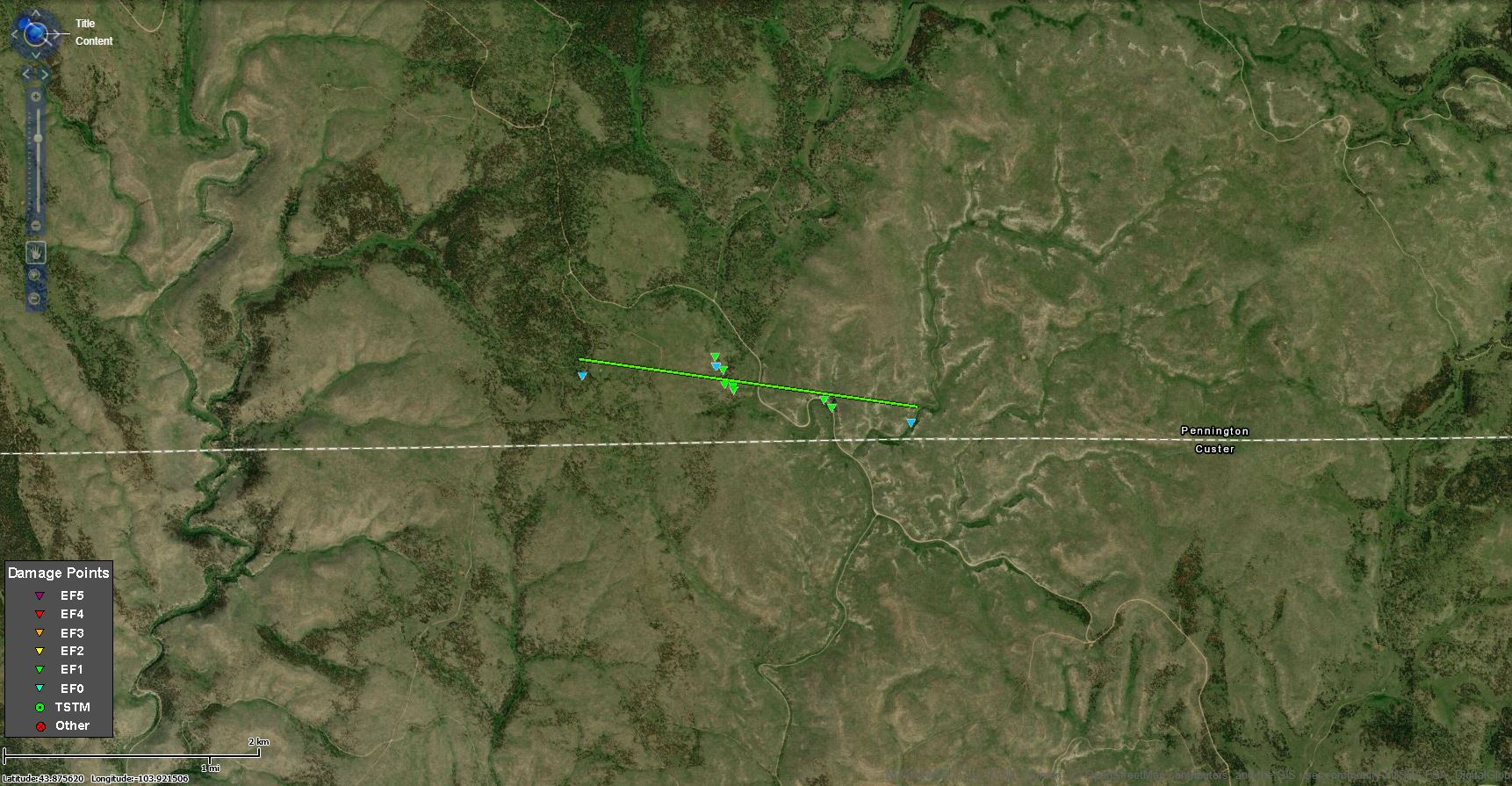  |
||||||||||||||||
 |
 |
| Damage photo from Asher and Betsy Kahler | Damage photo from NWS storm survey |
|
Tornado - 7 mi WNW Rochford
Track Map 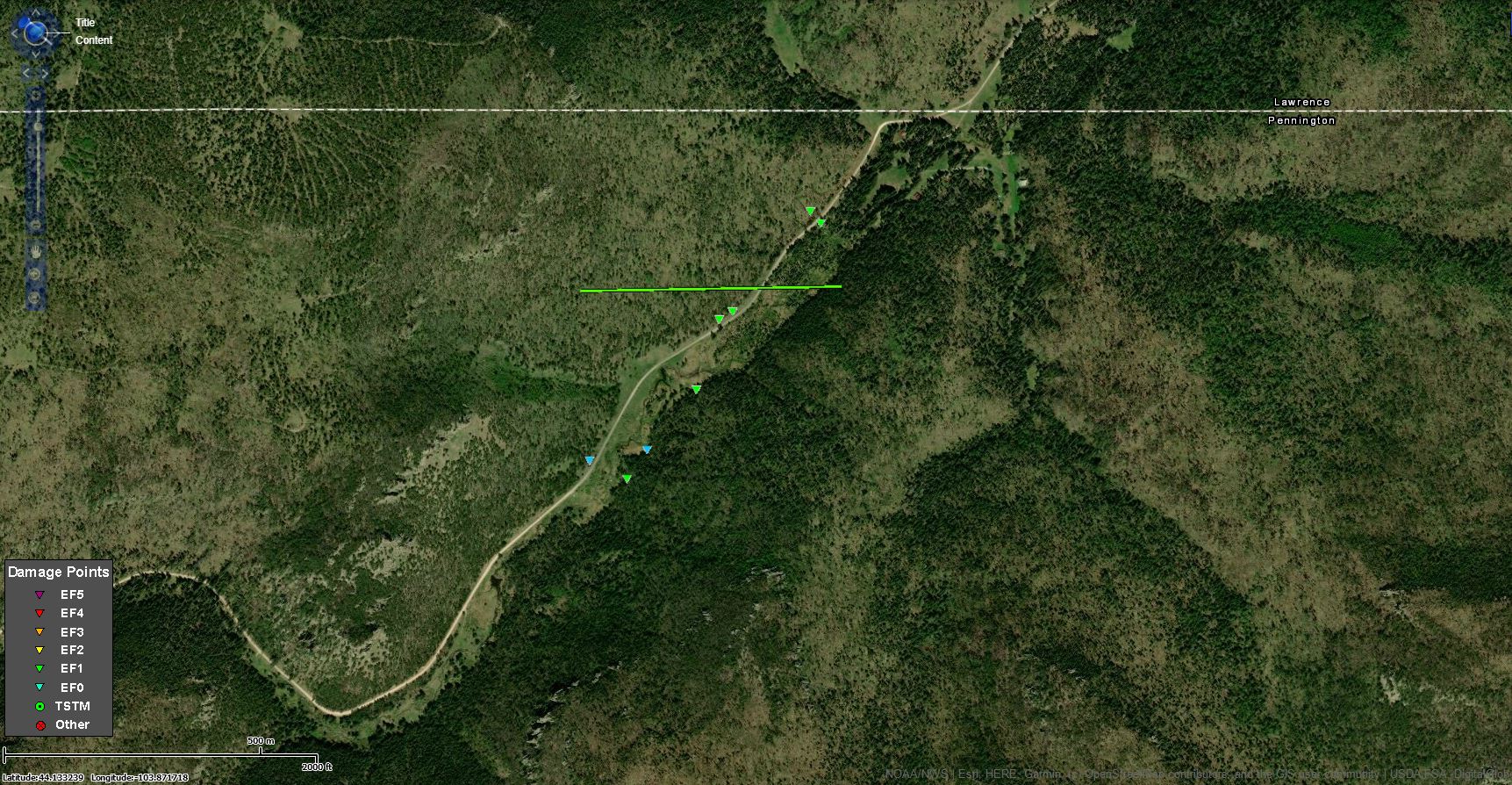 |
||||||||||||||||
 |
 |
| Damage photo from NWS storm survey | Damage photo from NWS storm survey |
|
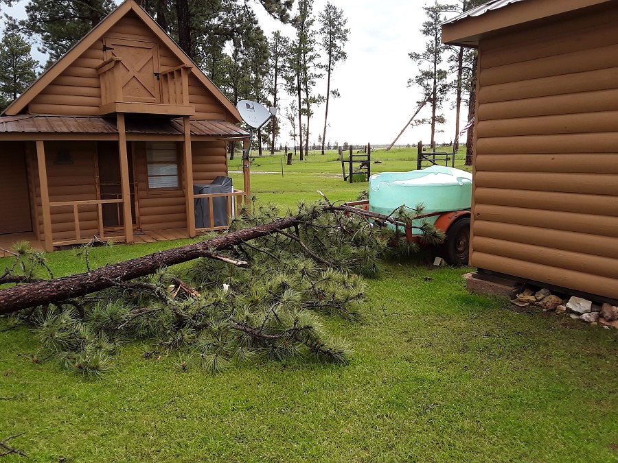
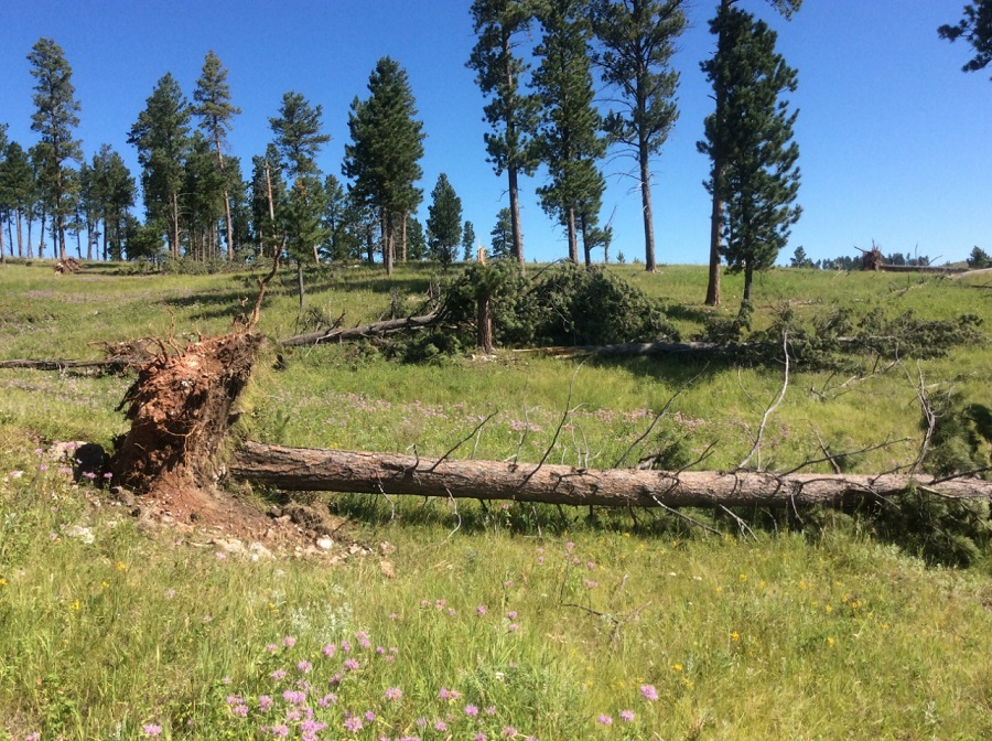
Tornado - 2 to 3.5 mi NE Deerfield Dam
Track Map 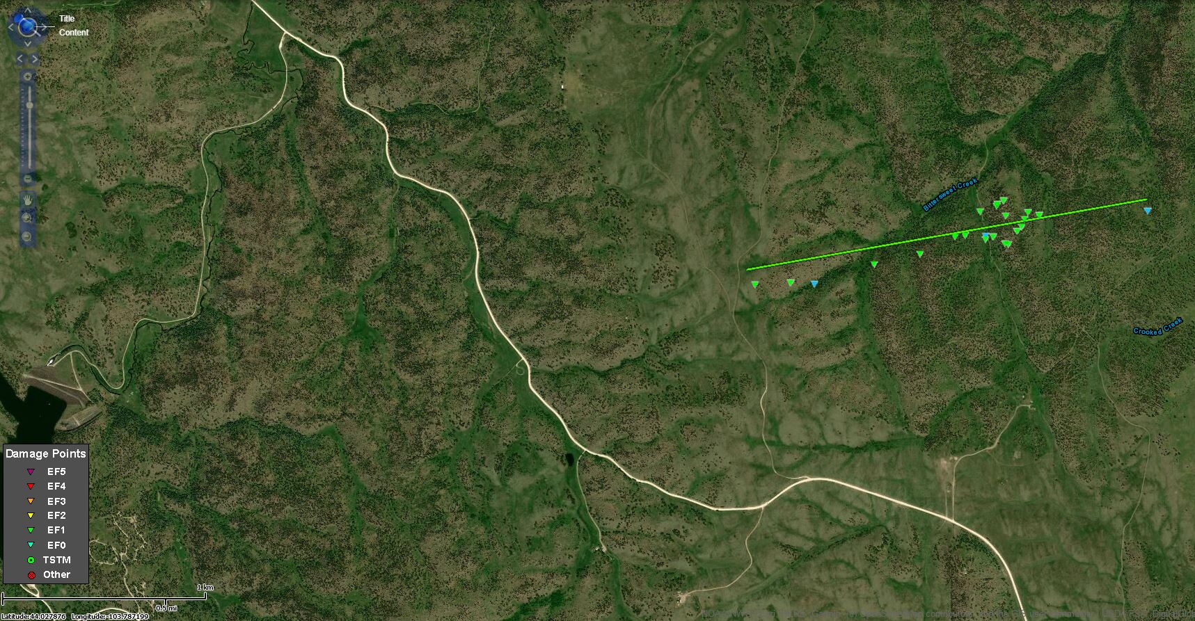 |
||||||||||||||||
 |
 |
| Damage photo from NWS storm survey | Damage photo from NWS storm survey |
The Enhanced Fujita (EF) Scale classifies tornadoes into the following categories:
| EF0 Weak 65-85 mph |
EF1 Moderate 86-110 mph |
EF2 Significant 111-135 mph |
EF3 Severe 136-165 mph |
EF4 Extreme 166-200 mph |
EF5 Catastrophic 200+ mph |
 |
|||||
Wind & Hail:
Strong winds and large hail were reported throughout the area. A 104 mph wind gust was reported a mile northeast of Midland, SD, while a 108 mph wind gust was measured in Stanley County four miles north northeast of Bunker, SD. Two inch diameter hail was reported four miles south of Rapid City, SD with golf ball sized hail six miles west of Oshoto, WY.
 |
 |
| Photo taken from Brean Road about 5 miles west of Highway 59 (Kelly Anderson) |
Photo taken from Brean Road about 5 miles west of Highway 59 (Kelly Anderson) |
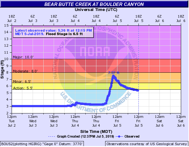
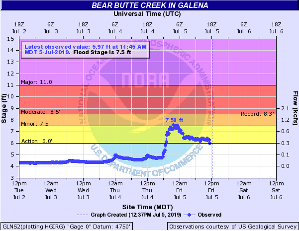
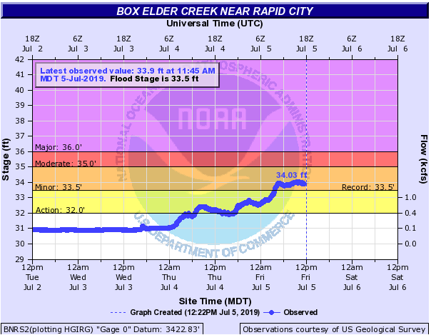
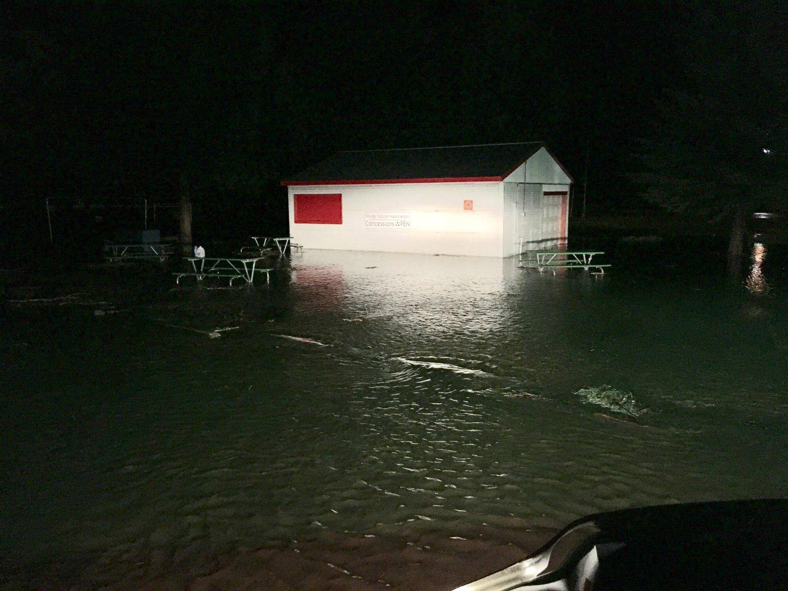
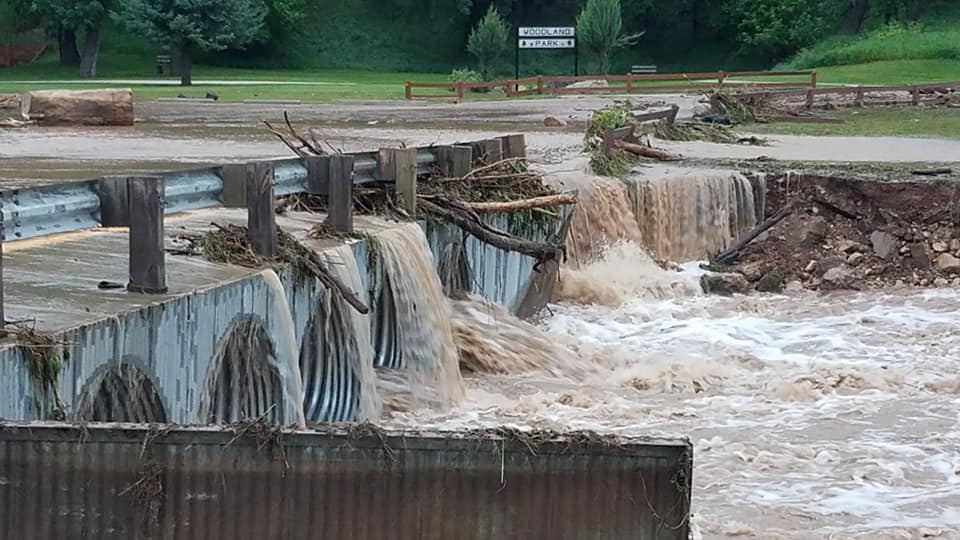
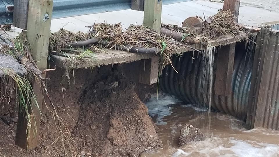
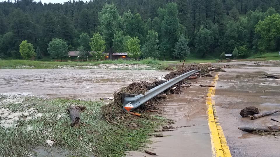
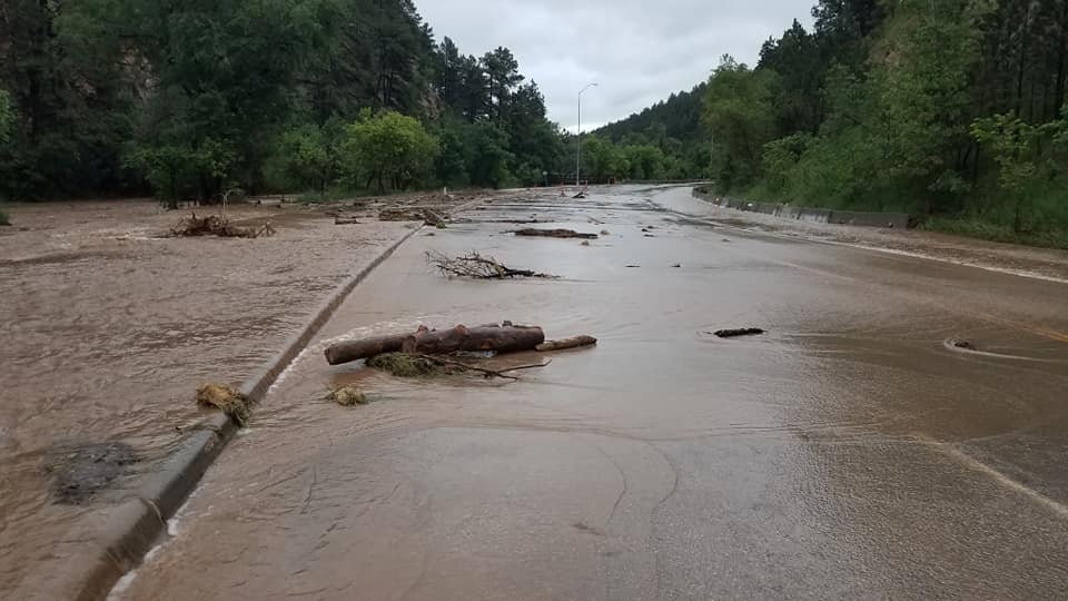
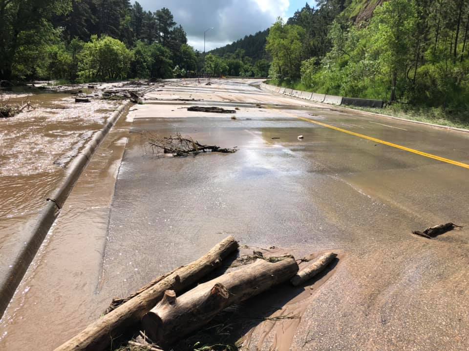
Flooding
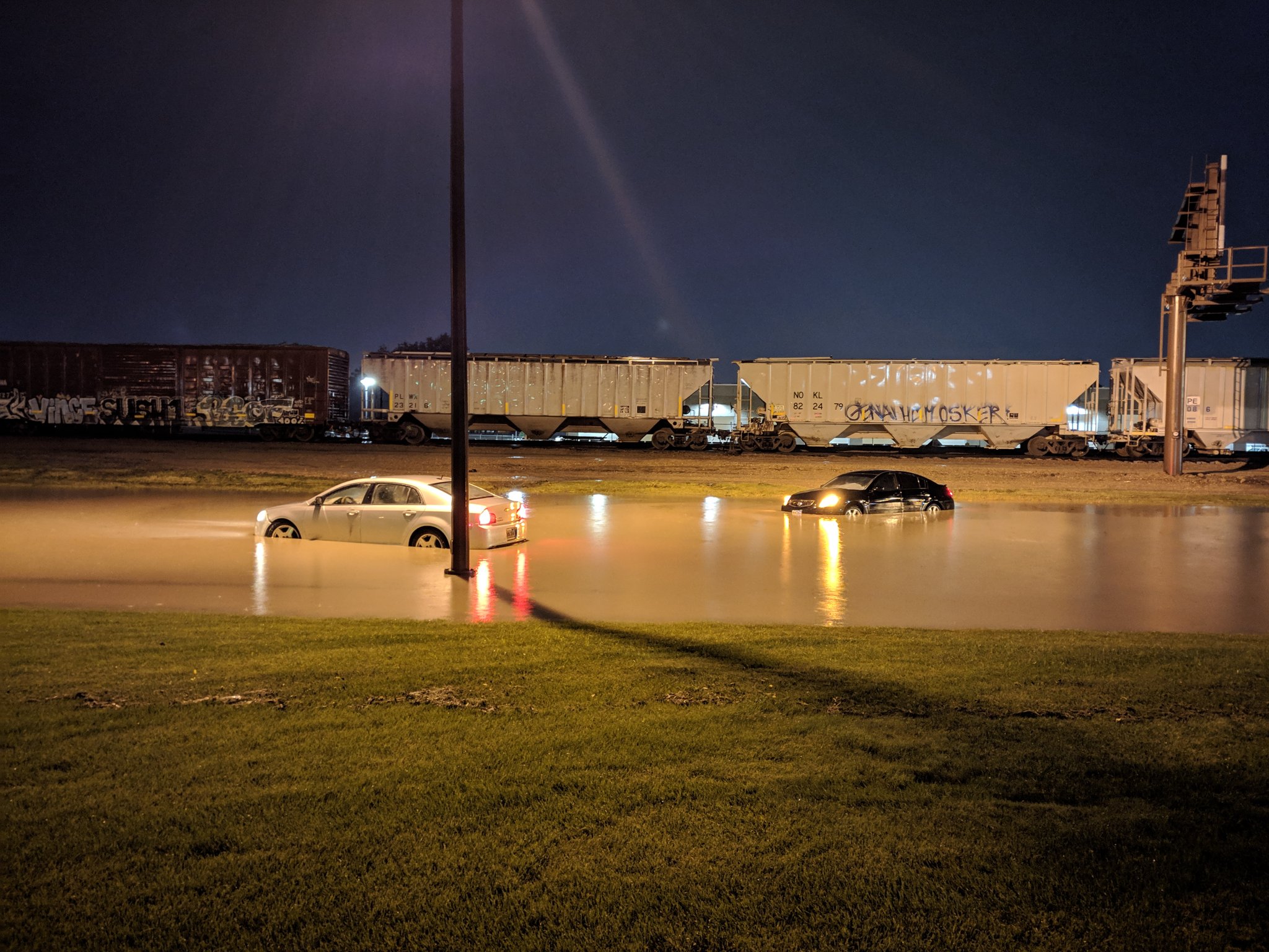
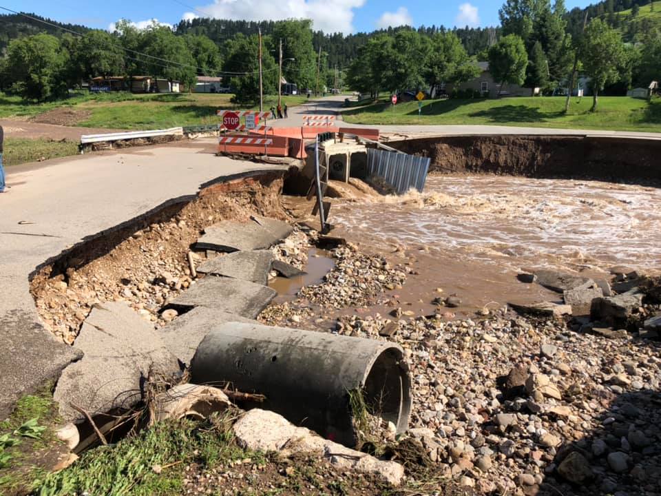
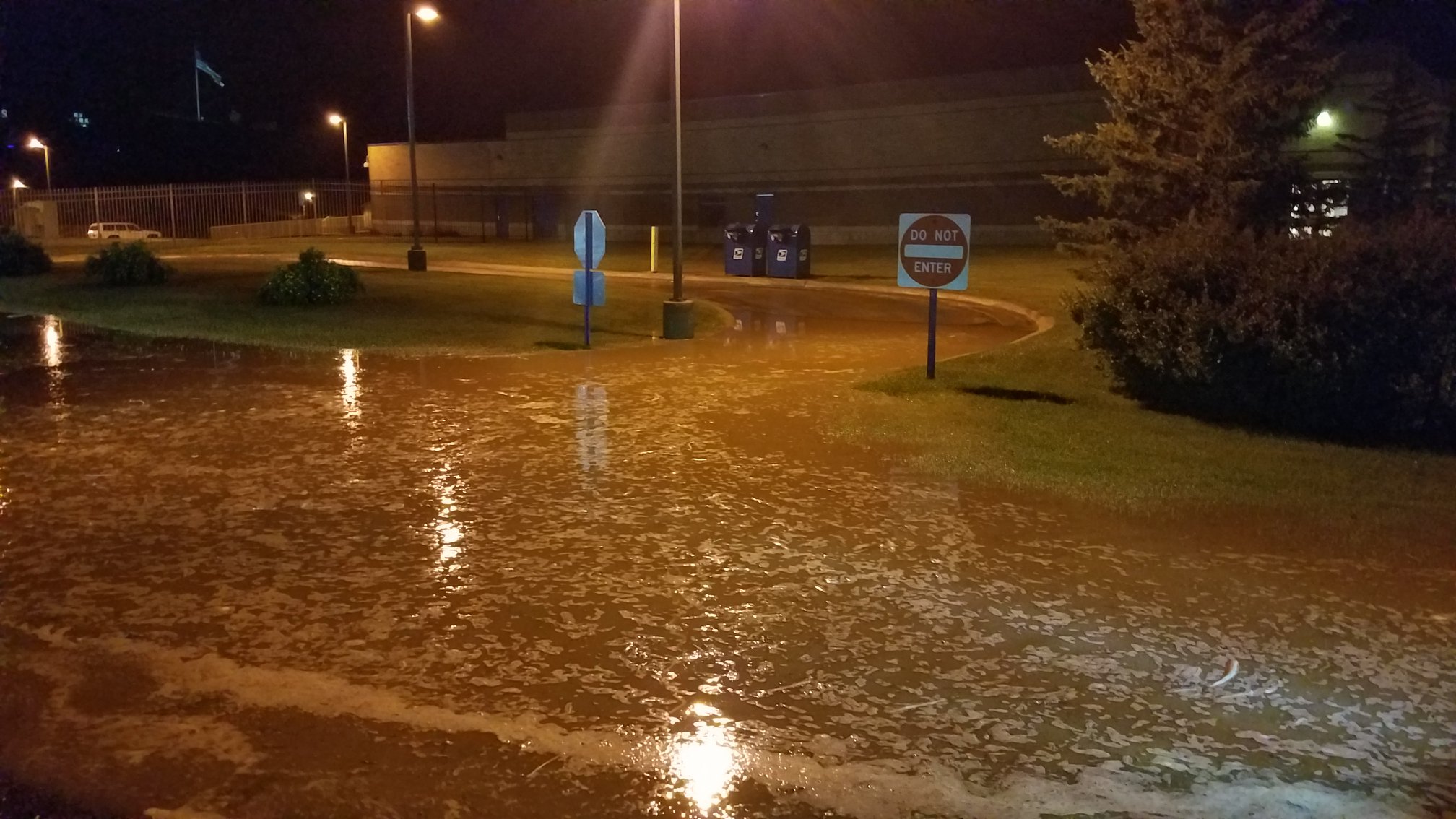
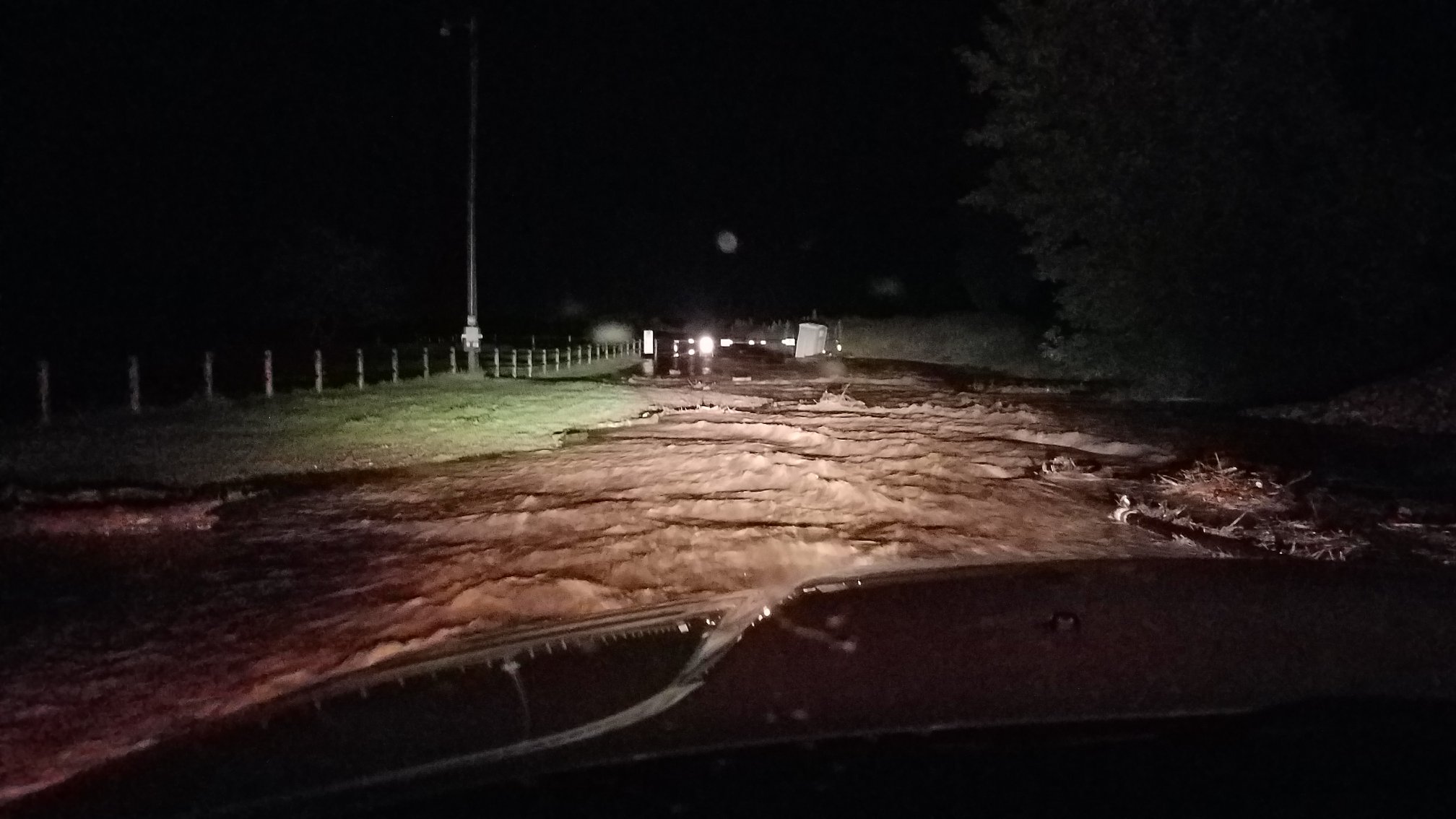
Extensive flooding occurred along Bear Butte Creek in Boulder Canyon and Sturgis. Highway 34 was covered with water at the "S-curves" between Sturgis and Fort Meade, the City Park was completely underwater, the 7th Street Bridge at Bear Butte Creek was inundated, as well as most of the other crossings over Bear Butte Creek in Sturgis. In Rapid City, multiple vehicles were stalled on area roads with several water rescues performed, portions of Saint Joseph Street near South Dakota School of Mines & Technology was underwater, and water was running curb to curb on Omaha Street, Mount Rushmore Road, West Boulevard, and Main Street. In Lawrence County, flooding occurred along Bear Butte Creek in Boulder Canyon near the Golf Course, a landslide on Galena Road occurred and culverts were blocked by water and debris, Ruby Flats and Englewood roads were flooded, as well as a portion of Two Bit Road and also Yellow Creek Road.
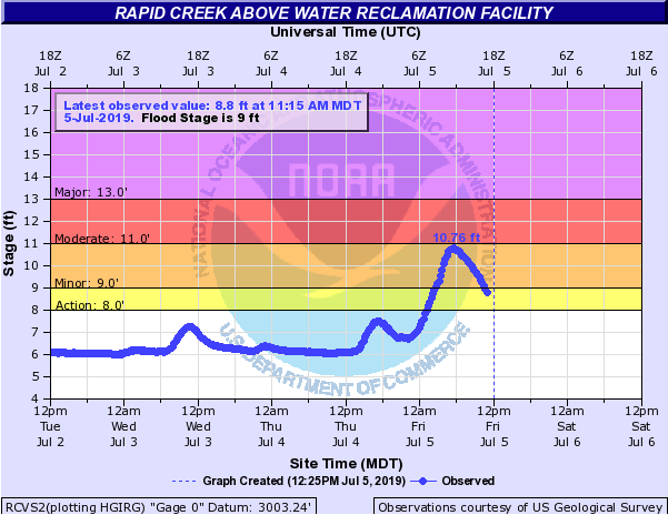
Hydrographs
 |
 |
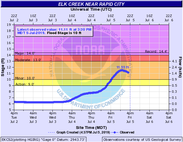 |
| Bear Butte Creek in Boulder Canyon | Bear Butte Creek in Galena | Elk Creek north of Rapid City |
 |
 |
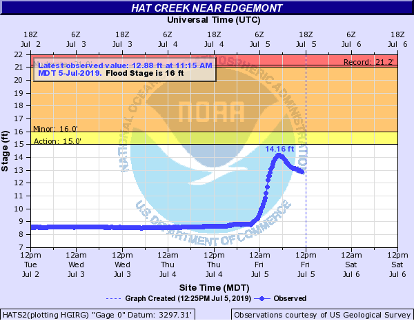 |
| Box Elder Creek near Rapid City | Rapid Creek in Rapid Valley | Hat Creek on Highway 71 (between Ardmore & Cascade Falls) |
Photos & Videos
 |
 |
 |
 |
| Flooding on Saint Joseph Street near SDSM&T (photo by Shailabh) | 7th Street Bridge in Sturgis (photo from Meade County EM) | Bear Butte Creek Flooding in Sturgis (photo from City of Sturgis) | Bear Butte Creek Flooding in Sturgis (photo from City of Sturgis) |
 |
 |
 |
 |
| Bear Butte Creek Flooding in Sturgis (photo from City of Sturgis) | Bear Butte Creek Flooding in Sturgis (photo from City of Sturgis) | Bear Butte Creek Flooding in Sturgis (photo from City of Sturgis) | Bear Butte Creek Flooding in Sturgis (photo from City of Sturgis) |
 |
 |
||
| Highway 34 in Sturgis "S-curves" around 6 AM (photo by City of Sturgis) |
Highway 34 in Sturgis "S-curves" around 945 AM (photo by Meade County EM) |
||
Radar
Above is the radar loop on July 4, 2019 from 600 PM MDT to midnight.
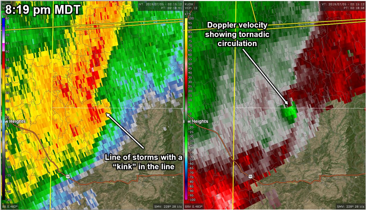
Here is a radar reflectivity image (left) and velocity image (right) at 8:19 pm MDT at the time the tornado was ongoing north-northwest of Jewell Cave. This was not a typical tornadic storm for our area because the tornado occurred in a line (whereas a lot of our tornadoes occur with isolated "supercell" thunderstorms).
 |
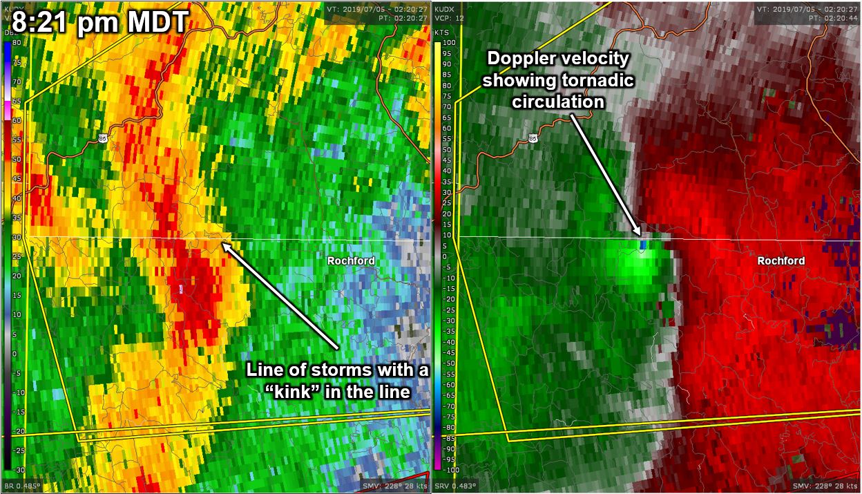
Here is a radar reflectivity image (left) and velocity image (right) at 8:21 pm MDT at the time the tornado occurred southwest of Black Fox Campground. This was not a typical tornadic storm for our area because the tornado occurred in a line (whereas a lot of our tornadoes occur with isolated "supercell" thunderstorms).
 |
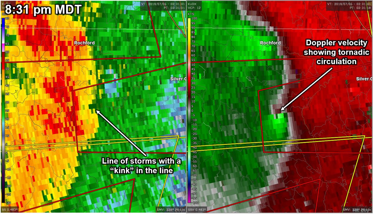
Here is a radar reflectivity image (left) and velocity image (right) at 8:31 pm MDT at the time the tornado occurred east-northeast of Deerfield Reservoir. This was not a typical tornadic storm for our area because the tornado occurred in a line (whereas a lot of our tornadoes occur with isolated "supercell" thunderstorms).
 |
Storm Reports
Here are the preliminary severe thunderstorm storm reports for July 4, 2019.
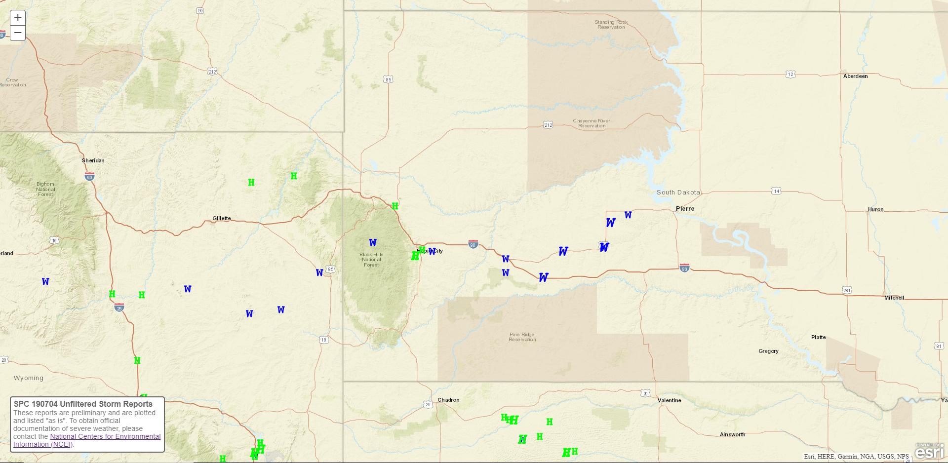 |
| Preliminary storm reports for July 4, 2019 (green H's represent hail; blue W's represent wind gusts). |
The storm reports listed below are in descending order and may not
necessarily be the final storm reports.

Hail reports listed by size (inches)

 SIZE    LOCATION                 ST  COUNTY           TIME
 ------  -----------------------  --  --------------   -------
  2.00   4 S DOWNTOWN RAPID CITY  SD  PENNINGTON       0900 PM
  1.75   6 W OSHOTO               WY  CROOK            0358 PM
  1.00   3 ESE DWTN RAPID CITY    SD  PENNINGTON       0905 PM
  1.00   2 E STURGIS              SD  MEADE            0645 PM
  1.00   2 S HULETT               WY  CROOK            0452 PM
  0.75   1 S BELLE FOURCHE        SD  BUTTE            0536 PM


Tstm wind reports listed by speed (mph)

 SPEED   LOCATION                 ST  COUNTY           TIME
 ------  -----------------------  --  --------------   -------
104.00   1 NE MIDLAND             SD  HAAKON           1124 PM
                 LOTS OF TREES DAMAGED, BRANCHES BROKEN, POWER
                 LINES DOWN.
 79.00   3 E PHILIP               SD  HAAKON           1045 PM
 79.00   4 E CACTUS FLAT          SD  JACKSON          1038 PM
 71.00   25 ESE WRIGHT            WY  CAMPBELL         0655 PM
                 TIME ESTIMATED USING RADAR
 70.00   8 S WALL                 SD  PENNINGTON       1005 PM
                 TIME ESTIMATED FROM RADAR
 69.00   6 WNW DOWNTOWN NEWCASTL  WY  WESTON           0755 PM
 65.00   1 NE MIDLAND             SD  HAAKON           1124 PM
 65.00   WALL                     SD  PENNINGTON       1014 PM
 62.00   RAPID CITY AIRPORT       SD  PENNINGTON       0906 PM
 60.00   ROCHFORD                 SD  PENNINGTON       0848 PM
                 RAPID CREEK OUT OF IT'S BANKS IN ROCHFORD.
 60.00   9 SSW CLARETON           WY  WESTON           0745 PM
 60.00   14 W WRIGHT              WY  CAMPBELL         0515 PM
                 RAIN OVER THE LAST 24 HOURS
 55.00   9 ENE BELVIDERE          SD  JACKSON          1119 PM
 53.00   4 S DOWNTOWN RAPID CITY  SD  PENNINGTON       0905 PM
 52.00   1 E DOWNTOWN RAPID CITY  SD  PENNINGTON       0909 PM


Rain amounts (inches)

 AMOUNT  LOCATION                 ST  COUNTY           TIME
 ------  -----------------------  --  --------------   -------
  5.25   STURGIS                  SD  MEADE            1010 AM
  3.00   14 W WRIGHT              WY  CAMPBELL         0515 PM
                 RAIN OVER THE LAST 24 HOURS
  2.79   5 ESE PIEDMONT           SD  MEADE            0700 AM
  2.68   5 ESE DWTN RAPID CITY    SD  PENNINGTON       0700 AM
  2.32   4 NE DWTN RAPID CITY     SD  PENNINGTON       0700 AM
  2.32   1 NE DWTN RAPID CITY     SD  PENNINGTON       0630 AM
                 RAINFALL LAST 24 HOURS.
  2.20   3 WNW DWTN RAPID CITY    SD  PENNINGTON       0700 AM
  2.12   2 SSE DWTN RAPID CITY    SD  PENNINGTON       0700 AM
  2.03   1 ESE DWTN RAPID CITY    SD  PENNINGTON       0610 AM
                 RAINFALL TOTAL YESTERDAY
  1.99   3 WNW DWTN RAPID CITY    SD  PENNINGTON       0700 AM
  1.91   4 NW DOWNTOWN RAPID CIT  SD  PENNINGTON       0841 AM
  1.91   5 SW DWTN RAPID CITY     SD  PENNINGTON       0700 AM
  1.75   6 ESE BOX ELDER          SD  PENNINGTON       0700 AM
  1.74   6 SW DWTN RAPID CITY     SD  PENNINGTON       0700 AM
  1.74   4 NE ROCKERVILLE         SD  PENNINGTON       0630 AM
                 RAINFALL LAST 24 HOURS.
  1.50   TILFORD                  SD  MEADE            0700 AM
  1.49   7 W DWTN RAPID CITY      SD  PENNINGTON       0700 AM
  1.45   12 SE BUFFALO GAP        SD  FALL RIVER       0700 AM
  1.45   7 NE SMITHWICK           SD  FALL RIVER       0645 AM
                 RAINFALL LAST 24 HOURS.
  1.37   22 SSW WASTA             SD  PENNINGTON       0700 AM
  1.36   ORAL                     SD  FALL RIVER       0840 AM
  1.35   2 ENE MIDLAND            SD  HAAKON           0700 AM
  1.33   10 ESE HERMOSA           SD  CUSTER           0700 AM
  1.33   7 WSW FOLSOM             SD  CUSTER           0515 AM
                 RAINFALL LAST 24 HOURS.
  1.31   MOUNT RUSHMORE           SD  PENNINGTON       0839 AM
  1.30   HOT SPRINGS              SD  FALL RIVER       0700 AM
  1.29   6 NNE DWTN RAPID CITY    SD  MEADE            0700 AM
  1.29   3 NNE JOHNSON SIDING     SD  PENNINGTON       1048 AM
  1.23   2 E COTTONWOOD           SD  JACKSON          0836 AM
  1.18   8 WNW HILL CITY          SD  PENNINGTON       0700 AM
  1.18   6 SSW MYSTIC             SD  PENNINGTON       0645 AM
                 RAINFALL LAST 24 HOURS.
  1.09   HILL CITY                SD  PENNINGTON       0837 AM
  1.07   5 E ELM SPRINGS          SD  MEADE            0836 AM
  1.07   1 E WINNER               SD  TRIPP            0700 AM
  1.06   7 E LAKEVIEW             SD  TODD             0839 AM
  1.06   10 WNW DWTN RAPID CITY   SD  PENNINGTON       0700 AM
  1.04   3 NNW LEAD               SD  LAWRENCE         0700 AM
  1.04   1 E WRIGHT               WY  CAMPBELL         0801 PM
  1.00   3 WNW KADOKA             SD  JACKSON          0700 AM
  1.00   3 WNW KADOKA             SD  JACKSON          0613 AM
                 RAINFALL LAST 24 HOURS.
  0.96   3 ENE KYLE               SD  OGLALA LAKOTA    0838 AM
  0.96   4 W HOT SPRINGS          SD  FALL RIVER       0700 AM
  0.96   1 S RENO JUNCTION        WY  CAMPBELL         0950 AM
  0.93   3 SE PHILIP              SD  HAAKON           0700 AM
  0.90   RED OWL                  SD  MEADE            0843 AM
  0.88   1 ESE PACTOLA RESERVOIR  SD  PENNINGTON       0841 AM
  0.88   7 ENE NEWELL             SD  BUTTE            0700 AM
  0.84   HILL CITY                SD  PENNINGTON       0753 AM
  0.84   7 NNE BATESLAND          SD  BENNETT          0700 AM
  0.83   2 SSW NORRIS             SD  MELLETTE         0700 AM
  0.83   14 ENE MARTIN            SD  BENNETT          0700 AM
  0.81   HERMOSA                  SD  CUSTER           0700 AM
  0.80   STURGIS                  SD  MEADE            0714 PM
                 IN 1 HOUR
  0.75   1 WNW HOOVER             SD  BUTTE            1127 AM
  0.70   4 SSW HILL CITY          SD  PENNINGTON       0700 AM
  0.70   1 ENE ROCHFORD           SD  PENNINGTON       1016 AM
                 FELL IN 30 MINUTES
  0.66   10 NNW WINNER            SD  TRIPP            0700 AM
  0.66   1 SSE BELLE FOURCHE      SD  BUTTE            0700 AM
  0.66   VALE                     SD  BUTTE            0700 AM
  0.66   LEAD                     SD  LAWRENCE         0927 AM
  0.64   14 SSE MISSION           SD  TODD             0700 AM
  0.64   15 SSE BELVIDERE         SD  MELLETTE         0700 AM
  0.59   17 NW WHITE RIVER        SD  MELLETTE         0700 AM
  0.56   24 SW BISON              SD  PERKINS          0700 AM
  0.55   36 W FAITH               SD  MEADE            0700 AM
  0.55   7 NNW DWTN SPEARFISH     SD  LAWRENCE         0700 AM
  0.53   13 ENE WHITE RIVER       SD  MELLETTE         0700 AM
  0.51   20 SSE BISON             SD  PERKINS          0700 AM
  0.51   4 NNW WHITEWOOD          SD  LAWRENCE         0700 AM
  0.50   2 W OPAL                 SD  MEADE            0838 AM


--------------------------------------------------------------

Flooding and Flash Flooding was reported along Bear Butte Creek
in Sturgis and in Boulder Canyon between Sturgis and Deadwood, as
well as Downtown Rapid City and Rapid Valley.
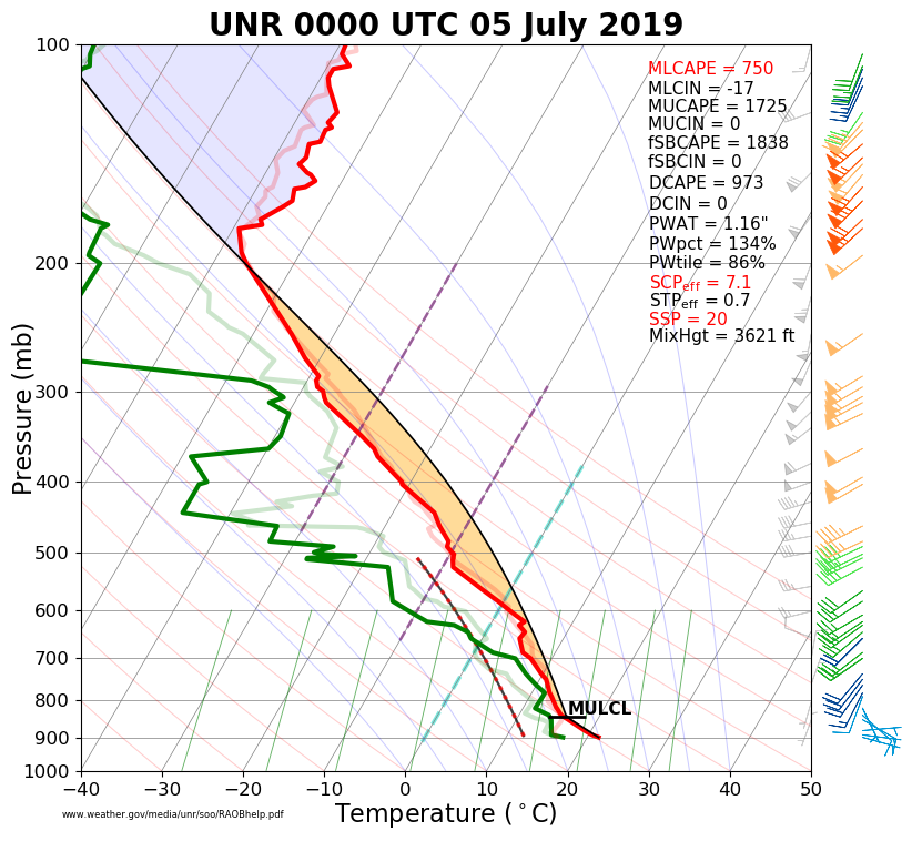
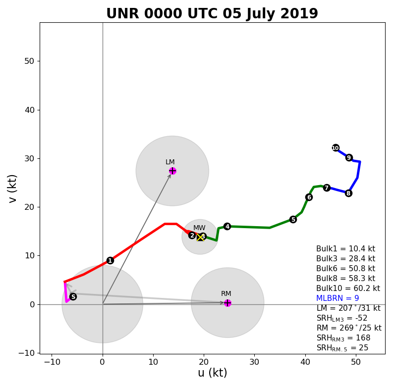
Environment
The atmosphere was unstable over the Black Hills area on Thursday, July 4th, 2019, per the information obtained from the weather balloon released in East Rapid City at 6 pm MDT (left image). The vertical wind shear (right image) was rather strong, which favored severe storms and damaging winds.
 |
 |
|
| July 4, 2019, 6 pm upper-air sounding for Rapid City (00z on the 5th) |
|
 |
Media use of NWS Web News Stories is encouraged! Please acknowledge the NWS as the source of any news information accessed from this site. |
|

