Scattered thunderstorms with severe gusts, hail and a tornado risk are possible near a cold front from the Ohio Valley to the Mid-Atlantic tonight. Tropical Storm Bertha is expected to bring tropical storm conditions to portions of the Gulf Coast from the panhandle of Florida into Louisiana through Wednesday. Read More >
Overview
|
Severe thunderstorms marched across northeastern Wyoming and the Black Hills area the afternoon and evening of July 17, 2019. Tennis ball to baseball size hail was reported around Gillette and the northern Black Hills, and a tornado occurred near Four Corners, Wyoming. Higher concentrations of cloud-to-ground lightning flashes can be seen in these areas in the image to the right. |
.png) 24-hour cloud-to-ground lightning from 6 am July 17 to 6 am July 18, 2019 |
Tornado:
|
Tornado - Four Corners
Track Map 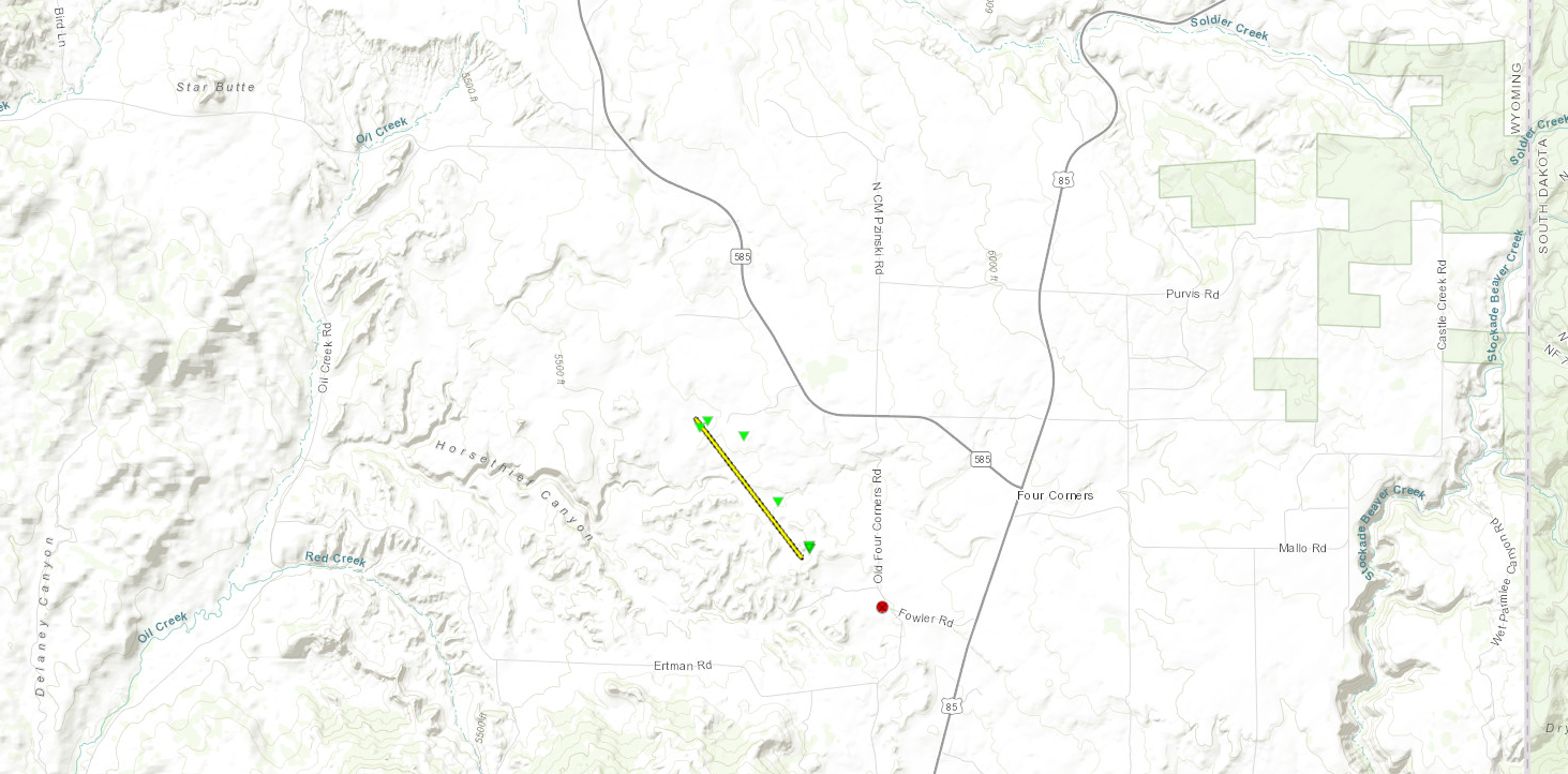  |
||||||||||||||||
The Enhanced Fujita (EF) Scale classifies tornadoes into the following categories:
| EF0 Weak 65-85 mph |
EF1 Moderate 86-110 mph |
EF2 Significant 111-135 mph |
EF3 Severe 136-165 mph |
EF4 Extreme 166-200 mph |
EF5 Catastrophic 200+ mph |
 |
|||||
Satellite Loop
The Rapid City NWS radar was not working on Wednesday, July 17, 2019, because of a lightning strike the night before. Therefore, we relied heavily on GOES-17 1-min satellite and lightning data. Below is a visible animation (10-min interval to reduce file size) showing the developing storms in northeastern Wyoming that eventually moved across western South Dakota. A longer, infrared satellite animation is below that to illustrate the cold cloud-top temperatures associated with the strongest storms.
| Visible satellite loop from 2 pm to 7:45 pm MDT on July 17, 2019. Red plus signs represent positive cloud-to-ground lightning flashes (cyan is for negative flashes). |
| Infrared satellite loop from 2:15 pm to 10:30 pm MDT on July 17, 2019. Red plus signs represent positive cloud-to-ground lightning flashes (black is for negative flashes). |
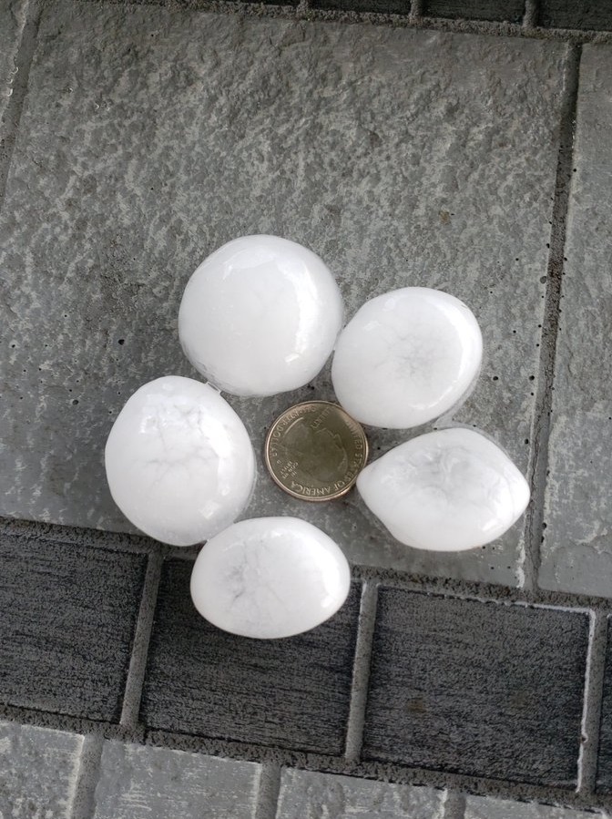
Photos & Video
Below are some photos of large hail that fell in the Gillette area (first row), along with damage to a vehicle from the Gillette Police Department (second row). The last picture at the bottom is a screen capture from a video of the tornado west of Four Corners, Wyoming.
 |
|
 |
| Hail estimated at golf ball size from Legacy Parkway & Stafford Bend in Gillette (photo courtesy Geno Palarazzi) |
Hail estimated at ping pong ball size from downtown Gillette (photo courtesy City of Gillette) |
Hail estimated at golf ball size from the north side of Gillette (photo courtesy Daren Wenzel) |
 |
|
 |
| Vehicle damage to police car (photo courtesy Gillette PD) |
Vehicle damage to police car (photo courtesy Gillette PD) |
Vehicle damage to police car (photo courtesy Gillette PD) |
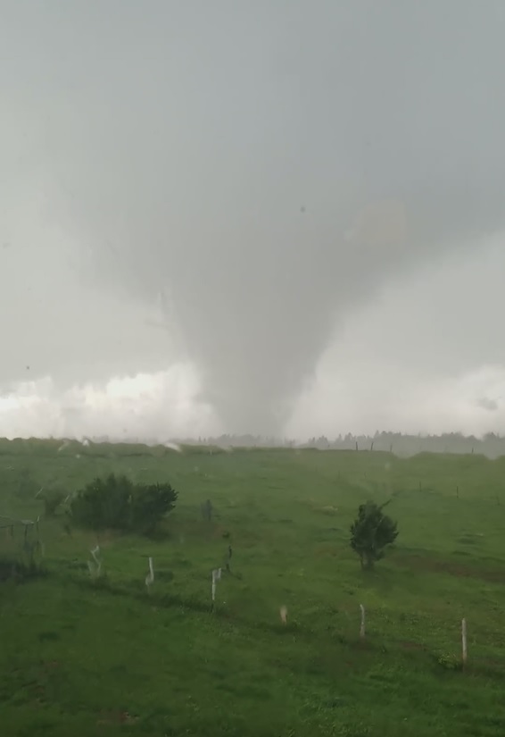 |
| Screen capture from video of tornado west of Four Corners, Wyoming. (photo courtesy Ryan & Jess Lorenz) |
Storm Reports
Here are the preliminary severe thunderstorm storm reports for July 17, 2019 (link to reports).
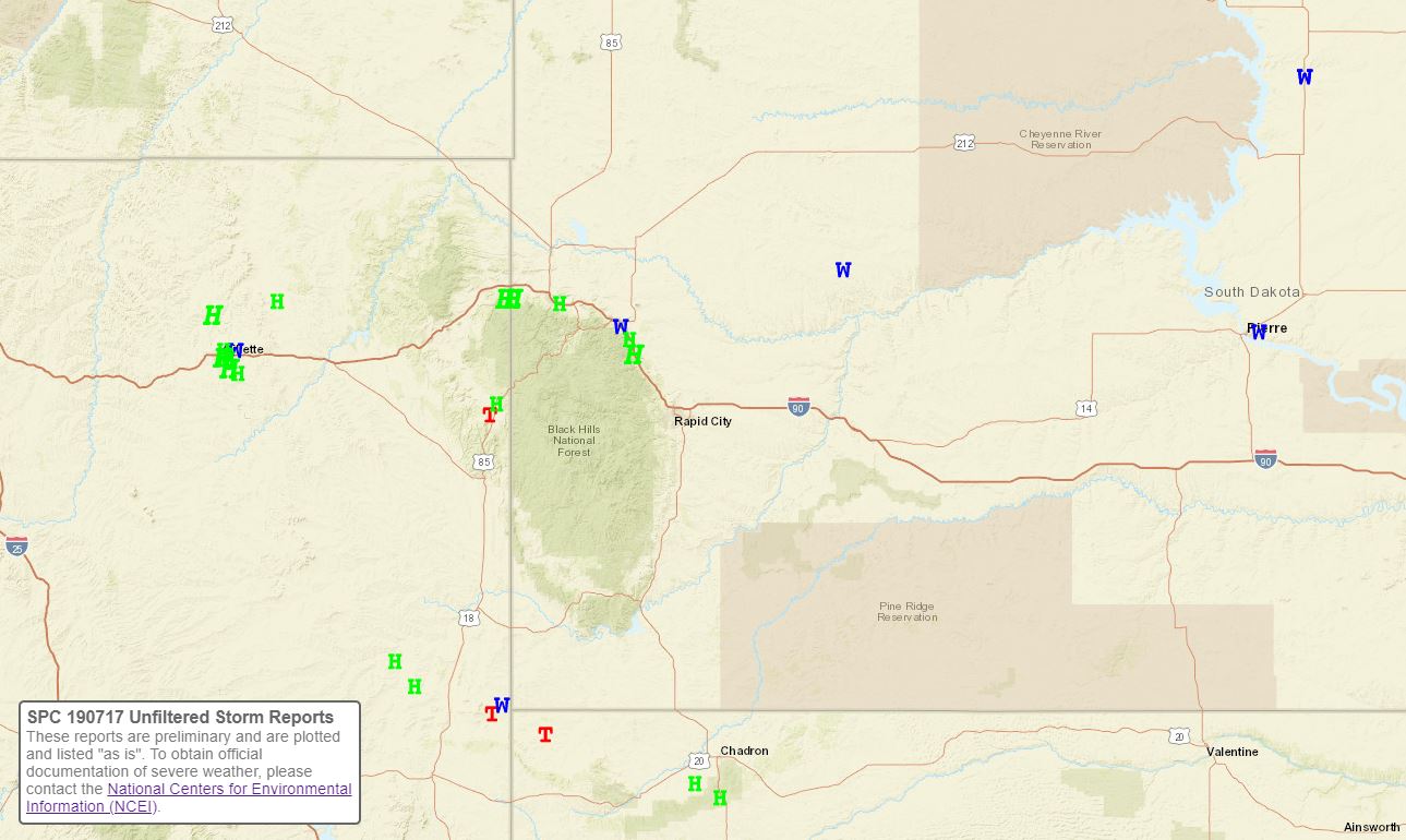 |
| Preliminary storm reports for July 17-18, 2019 (green H's represent hail; blue W's represent wind gusts; and red T's represent tornado reports). |
The storm reports listed below are in descending order and may not
necessarily be the final storm reports.

Hail reports listed by size (inches)
 SIZE    LOCATION                 ST  COUNTY           TIME
 ------  -----------------------  --  --------------   -------
  3.00   9 W DWTN SPEARFISH       SD  LAWRENCE         0615 PM
  2.50   TILFORD                  SD  MEADE            0710 PM
  2.50   2 S BEULAH               WY  CROOK            0559 PM
  2.25   3 SSE DWTN GILLETTE      WY  CAMPBELL         0510 PM
  2.00   DWTN GILLETTE            WY  CAMPBELL         0515 PM
  2.00   11 NNW DWTN GILLETTE     WY  CAMPBELL         0434 PM
  1.75   6 SE DWTN GILLETTE       WY  CAMPBELL         0528 PM
  1.75   1 ESE DWTN GILLETTE      WY  CAMPBELL         0515 PM
  1.75   1 N DWTN GILLETTE        WY  CAMPBELL         0456 PM
  1.50   1 S DWTN GILLETTE        WY  CAMPBELL         0502 PM
  1.25   9 W DWTN SPEARFISH       SD  LAWRENCE         0600 PM
  1.00   4 NNW TILFORD            SD  MEADE            0702 PM
  1.00   2 N FOUR CORNERS         WY  WESTON           0653 PM
  1.00   3 ESE DWTN SPEARFISH     SD  LAWRENCE         0630 PM
  1.00   11 SSE WESTON            WY  CAMPBELL         0456 PM
  0.75   MOORCROFT                WY  CROOK            0545 PM
  0.70   4 SE PINE HAVEN          WY  CROOK            0613 PM
Tstm wind reports listed by speed (mph)

 SPEED   LOCATION                 ST  COUNTY           TIME
 ------  -----------------------  --  --------------   -------
 65.00   2 ENE WHITE OWL          SD  MEADE            0810 PM
 60.00   1 SSE STURGIS            SD  MEADE            0700 PM
 57.00   2 SW BRIDGER             SD  ZIEBACH          0836 PM
 55.00   MOORCROFT                WY  CROOK            0545 PM
 52.00   4 E DWTN SPEARFISH       SD  LAWRENCE         0635 PM
 DAMAGE  3 ENE DWTN GILLETTE      WY  CAMPBELL         0500 PM
            POWER POLE SNAPPED AT THE BASE FROM STRONG WINDS. ALSO
            HAD SEVERAL REPORTS OF TENNIS BALL SIZED HAIL THROUGHOUT
            NORTHEASTERN GILLETTE THAT CAUSED EXTENSIVE DAMAGE.
Environment
The atmosphere was very unstable over northeastern Wyoming and western South Dakota on Wednesday, July 17th, 2019, per the information obtained from the weather balloon released in East Rapid City at 6 pm MDT (left image). The vertical wind shear (right image) was rather strong, which favored severe storms with especially large hail, but also damaging winds.
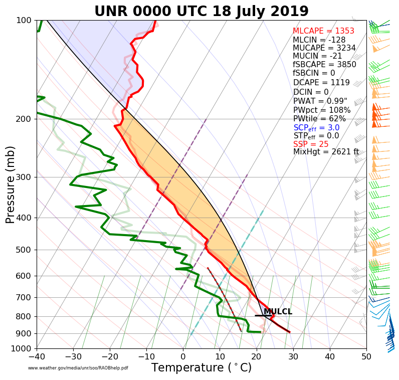 |
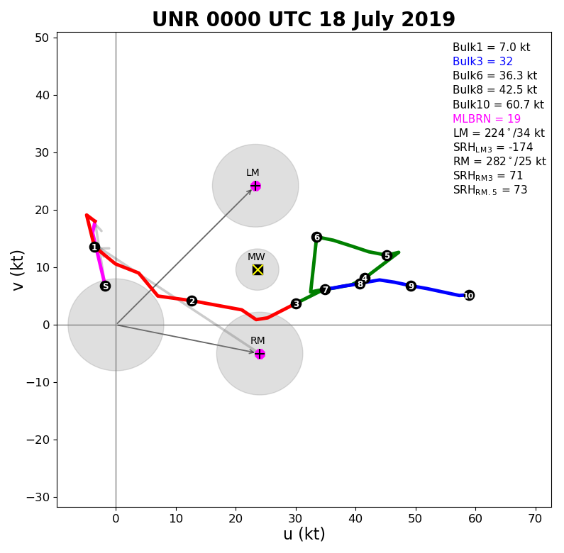 |
| July 17, 2019, 6 pm upper-air sounding for Rapid City (00z on the 18th) | July 17, 2019, 6 pm upper-air hodograph for Rapid City (00z on the 18th) |
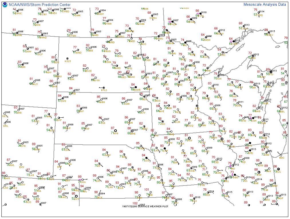
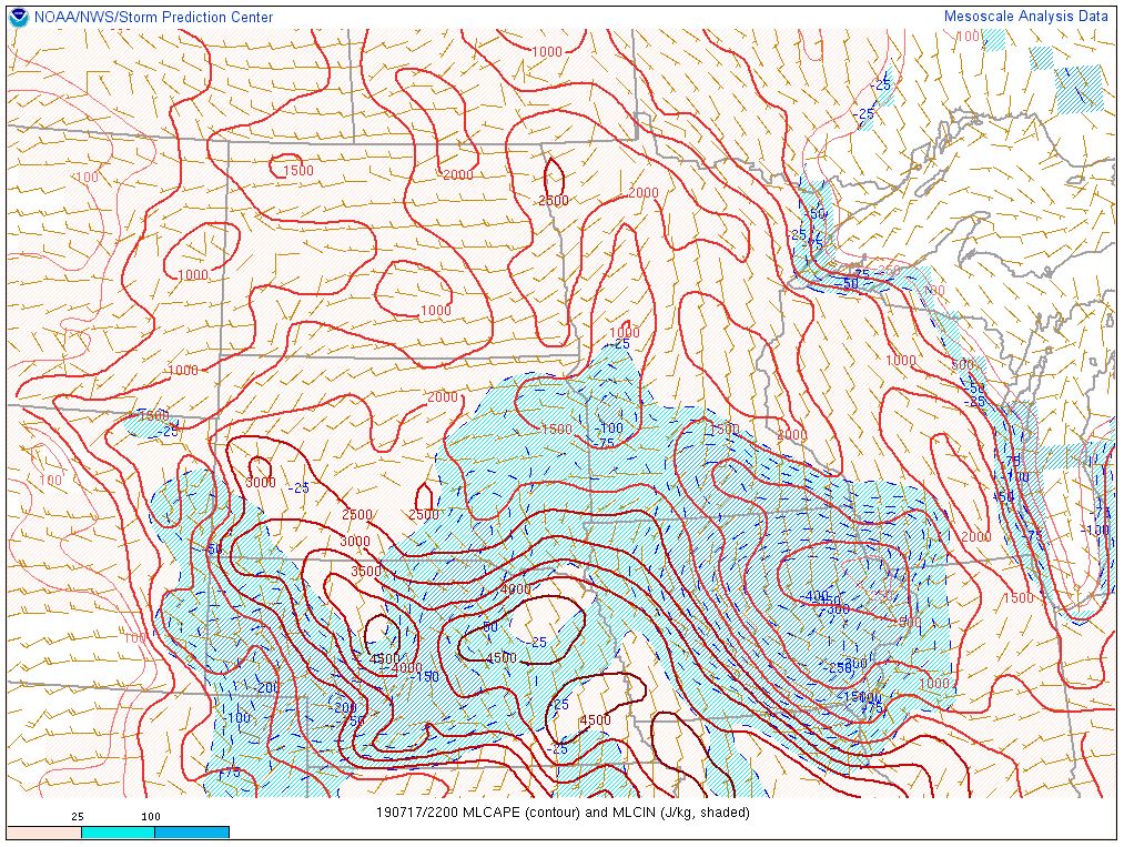
A moist and unstable air mass was in place with southeast winds bringing humid air into the region, per the images below. Strong winds well above the ground created more than sufficient vertical wind shear that is needed to sustain severe thunderstorms.
 |
 |
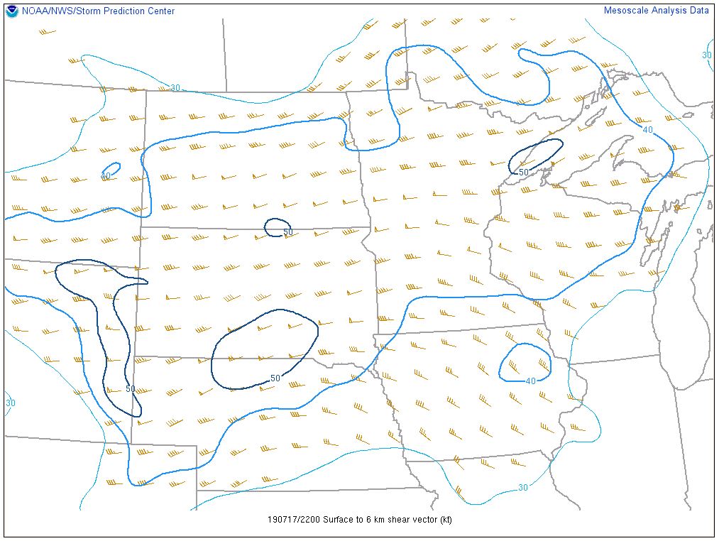 |
| SPC surface map valid 4 pm MDT 17 July 2019 | SPC mixed-layer CAPE (a measure of buoyancy) valid 4 pm MDT 17 July 2019 | SPC vertical wind shear from the surface to 6 km above ground (about 18,000 ft) valid 4 pm MDT 17 July 2019 |
 |
Media use of NWS Web News Stories is encouraged! Please acknowledge the NWS as the source of any news information accessed from this site. |
|