
Wildfires and poor air quality continue for the Pacific Northwest, Rockies and extended into the Plains. Severe thunderstorms possible for the northern Plains and upper Midwest on Monday along a frontal boundary. Another boundary will focus showers and thunderstorms for the eastern seaboard with localized heavy rainfall possible. For Alaska, a strong Bering Sea storm will bring winds and rainfall. Read More >
Overview
Nearly stationary thunderstorms developed over and near Custer, SD during the afternoon of August 2nd, 2019. Radar estimates indicated that 6-7" of rain fell to the west of Custer, with measured observations as high as 5.35". Rainwater moved downstream along French Creek, causing severe flooding in the town of Custer through the evening. Road closures and some evacuations were reported by the Custer County Sheriff's Office before water began to recede during the night of the 2nd into the morning of the 3rd.
Photos and Video
UAV (drone) Footage of the Flooding in Custer, courtesy of Custer County Search and Rescue
Flooding in Custer from Custer County Sheriff
Flooding in Custer from Custer County Search and Rescue
Flooding in Custer from Black Hills Energy
Rainfall and Flooding Reports
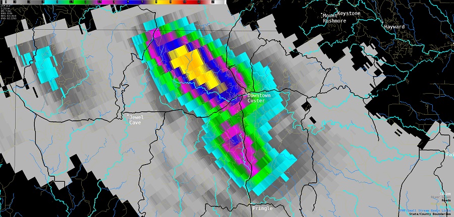 |
| Radar-estimated storm total rainfall near Custer during the afternoon of August 2nd, 2019 |
Radar loop from 12:30 PM through 4:45 PM on August 2nd, 2019
(for higher resolution, please view on YouTube)
..TIME... ...EVENT... ...CITY LOCATION... ...LAT.LON...
..DATE... ....MAG.... ..COUNTY LOCATION..ST.. ...SOURCE....
0257 PM HEAVY RAIN 1 SSW CUSTER 43.75N 103.61W
08/02/2019 M2.21 INCH CUSTER SD TRAINED SPOTTER
FELL IN 90 MINUTES
0400 PM FLASH FLOOD 3 WNW CUSTER 43.78N 103.66W
08/02/2019 CUSTER SD LAW ENFORCEMENT
RUBY CREEK BETWEEN CUSTER LIMESTONE ROAD AND UPPER
FRENCH CREEK ROAD OUT OF ITS BANKS.
0400 PM FLASH FLOOD 2 WSW CUSTER 43.76N 103.64W
08/02/2019 CUSTER SD SOCIAL MEDIA
WATER OVER UPPER FRENCH CREEK ROAD AT HOOVER COURT.
0412 PM HEAVY RAIN 6 WNW CUSTER 43.80N 103.71W
08/02/2019 M5.35 INCH CUSTER SD SOCIAL MEDIA
RESIDENT JUST OFF OF ELLIOT ROAD NW OF CUSTER.
Environment
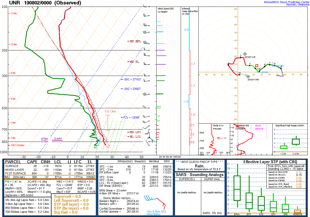
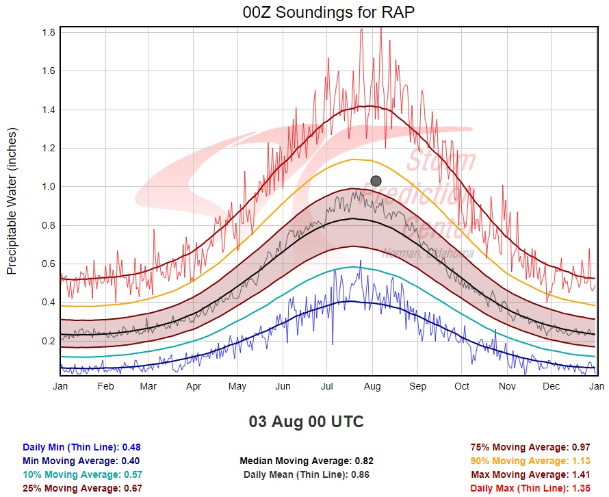
The near-storm environment on the evening of August 2nd, 2019 was favorable for slow-moving thunderstorms capable of heavy rainfall. Precipitable water (a measure of total atmospheric moisture content) values were between the 75th and 90th percentiles, meaning that moisture content was within the upper 25% of data on record for this time of year.
 |
 |
| Figure 1: August 2nd, 2019 upper-air sounding and hodograph for Rapid City, SD at 6 PM (00z on the 3rd) |
Figure 2: Comparison of precipitable water (measure of atmospheric moisture content) for Rapid City's August 2nd, 2019 evening sounding (shown as grey dot) to climatology |
 |
Media use of NWS Web News Stories is encouraged! Please acknowledge the NWS as the source of any news information accessed from this site. |
|

