
Dangerous heat will expand from the Gulf Coast into the Southern Plains and Desert Southwest through week's end. Additional extreme heat impacting the Pacific Northwest will shift to the northern Plains by the weekend. Tropical Storm Bertha is expected to continue to impact portions of the northwestern Gulf Coast from south central Louisiana to the upper Texas coast today. Read More >
Overview
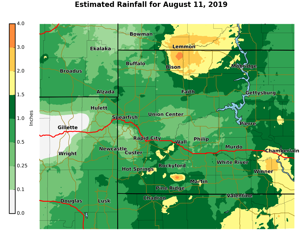
An area of low pressure and cold front moved through the Northern Plains during the afternoon and evening hours of August 11, 2019. This storm system, combined with above average water in the atmosphere, created numerous thunderstorms across most of western South Dakota. Runoff from the heavy rain caused flash flooding and flooding across portions of Oglala Lakota County. Three to five inches of rain was reported between Porcupine, Sharps Corner, and Kyle. A large amount of the precipitation fell over Iron Cloud Canyon, causing flash flooding of BIA 27 between Evergreen and Gooseneck Road. Several feet of fast moving water inundated BIA 27 and caused significant flooding of Porcupine Creek. As the flood waters continued along Porcupine Creek, BIA 2 just east of Sharps Corner was inundated by the morning of August 12th. Additional flooding along Porcupine Creek continued downstream to the White River.
Flooding
 |
Photos and Videos
| Facebook Video from OST Emergency Management of BIA 27 posted at 745 pm on 8/11/2019 |
| Twitter Video from @Tokalasina of BIA 27 |
— me (@tokalasina) August 12, 2019 |
| Facebook Video from Jess Killsback from KILI Radio 90.1 FM of Flooding below Evergreen |
| Twitter Video from Martin Vol Fire department of BIA 2 Hwy near Sharps Corner taken 8/12/2019 |
|
| Twitter Video from Martin Vol Fire Department by Jack Pourier Place in the Sharps Corner area |
|
| Facebook Photo from Fall River County Sheriff's Office of Rock Slide in Sheps Canyon |
Rainfall and Storm Reports
The storm reports listed below are in descending order and may not
necessarily be the final storm reports.

Rain amounts (inches)

 AMOUNT  LOCATION                 ST  COUNTY           TIME
 ------  -----------------------  --  --------------   -------
  3.42   6 WNW SHADEHILL          SD  PERKINS          0600 AM
  2.82   7 W SHADEHILL            SD  PERKINS          0650 PM
                 HEAVY RAIN FELL FROM 0620 TO 0650 PM MDT.
  2.81   5 NE PORCUPINE           SD  OGLALA LAKOTA    0800 AM
                 24 HOUR TOTAL
  2.31   2 WSW HAMILL             SD  TRIPP            0630 AM
  2.25   3 E WASTA                SD  PENNINGTON       0700 AM
  1.84   5 NE PORCUPINE           SD  OGLALA LAKOTA    0641 PM
                 RAINFALL BETWEEN 541 PM to 641 PM
  1.80   4 NE MARTIN              SD  BENNETT          1043 PM
  1.80   1 SW SHADEHILL           SD  PERKINS          0800 PM
                 RAINFALL FROM 600 PM TO 800 PM
  1.80   HERMOSA                  SD  CUSTER           0800 PM
  1.70   9 SW ANGOSTURA RES       SD  FALL RIVER       0800 AM
                 24 HOUR TOTAL
  1.70   1 N IDEAL                SD  TRIPP            0700 AM
  1.66   7 WSW FOLSOM             SD  CUSTER           0530 AM
  1.58   9 SW ANGOSTURA RES       SD  FALL RIVER       0600 PM
                 FELL IN 45 MINUTES
  1.57   1 NNE EDGEMONT           SD  FALL RIVER       0800 AM
                 24 HOUR TOTAL
  1.57   3 WNW KADOKA             SD  JACKSON          0500 AM
  1.55   1 NNE EDGEMONT           SD  FALL RIVER       0600 PM
                 FELL IN ONE HOUR
  1.54   2 ENE WASTA              SD  PENNINGTON       0830 PM
                 FELL IN 1.5 HOURS
  1.49   2 NNW ANGOSTURA RES      SD  FALL RIVER       0800 AM
                 24 HOUR TOTAL
  1.49   3 SE FARMINGDALE         SD  PENNINGTON       0800 PM
                 FELL IN 1.5 HOURS
  1.39   2 NNW ANGOSTURA RES      SD  FALL RIVER       0615 PM
                 FELL IN 1.5 HOURS
  1.34   1 WSW WINNER             SD  TRIPP            0700 AM
  1.28   1 S DWTN RAPID CITY      SD  PENNINGTON       0815 PM
                 STORM TOTAL RAINFALL
  1.24   1 NNE EDGEMONT           SD  FALL RIVER       0600 AM
  1.23   2 SW NORRIS              SD  MELLETTE         0700 AM
  1.17   4 W MARTIN               SD  BENNETT          0921 PM
                 STORM TOTAL RAINFALL
  1.08   3 ENE KYLE               SD  OGLALA LAKOTA    0700 AM
  1.05   8 E MARTIN               SD  BENNETT          0700 AM
Hail reports listed by size (inches)

 SIZE    LOCATION                 ST  COUNTY           TIME
 ------  -----------------------  --  --------------   -------
  1.00   LUDLOW                   SD  HARDING          0532 PM
                 A LOT OF PEA SIZE HAIL WITH A FEW NICKELS AND
                 QUARTERS
  1.00   5 W SHARPS CORNER        SD  OGLALA LAKOTA    0355 PM


Tstm wind reports listed by speed (mph)

 SPEED   LOCATION                 ST  COUNTY           TIME
 ------  -----------------------  --  --------------   -------
 73.00   5 NE PORCUPINE           SD  OGLALA LAKOTA    0630 PM
 70.00   WALL                     SD  PENNINGTON       0730 PM
 67.00   3 WSW FAIRBURN           SD  CUSTER           0625 PM
 66.00   10 W EDGEMONT            SD  FALL RIVER       0459 PM
 61.00   3 E PHILIP               SD  HAAKON           0809 PM
 60.00   MARTIN                   SD  BENNETT          0750 PM
 60.00   OGLALA                   SD  OGLALA LAKOTA    0615 PM
 60.00   1 W EDGEMONT             SD  FALL RIVER       0508 PM
                 PEA SIZE HAIL...WIND GUSTS 50 TO 60 MPH
 59.00   1 NE WINNER              SD  TRIPP            1053 PM
 55.00   8 WNW FAIRBURN           SD  CUSTER           0620 PM
 54.00   4 E CACTUS FLAT          SD  JACKSON          0745 PM
 54.00   3 NNW SCENIC             SD  PENNINGTON       0702 PM
 52.00   8 W JEWEL CAVE           SD  CUSTER           0524 PM
 51.00   9 SW BATESLAND           SD  OGLALA LAKOTA    0700 PM
 50.00   NEW UNDERWOOD            SD  PENNINGTON       0700 PM
Radar and Environment
| Figure 1: Radar Loop from Noon to Midnight on August 11, 2019 (for higher resolution, please view on YouTube) |
The near-storm environment on the afternoon of August 11, 2019 was favorable for slow-moving thunderstorms capable of heavy rainfall. Precipitable water (a measure of total atmospheric moisture content) values were just above the 90th percentiles, meaning that moisture content was within the upper 10% of data on record for this time of year.
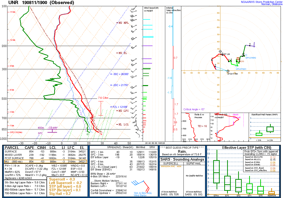 |
| Figure 2: August 11, 2019 upper-air sounding for Rapid City, SD at 1 PM (19Z). PW (precipitable water) of 1.19 in; daily mean 0.86 in and moving average is 0.79 in |
 |
Media use of NWS Web News Stories is encouraged! Please acknowledge the NWS as the source of any news information accessed from this site. |
|

