
Dangerous heat will expand from the Gulf Coast into the Southern Plains and Desert Southwest through week's end. Additional extreme heat impacting the Pacific Northwest will shift to the northern Plains by the weekend. Tropical Storm Bertha is expected to continue to impact portions of the northwestern Gulf Coast from south central Louisiana to the upper Texas coast today. Read More >
Overview
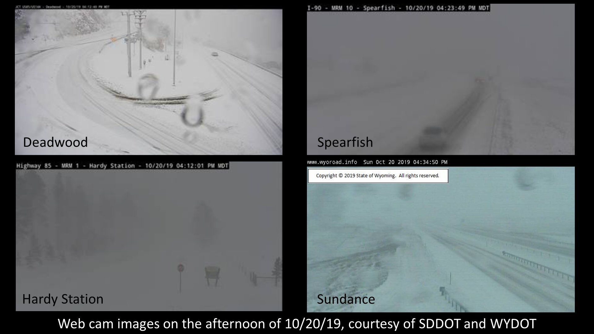
On Sunday, October 20, 2019, a strong storm brought heavy snow to the Black Hills, with a mix of rain and snow to the foothills. Note how the snow cover (red in image below) is strongly confined to the Black Hills and other higher terrain areas to the northwest. Travel became difficult in parts of the northern Black Hills per the webcam images below. The storm also produced very strong winds, with gusts of 60 to 70 mph in locations. In addition, an unofficial gust of 83 mph was reported 1 mile east-southeast of Custer at 509 pm MDT.
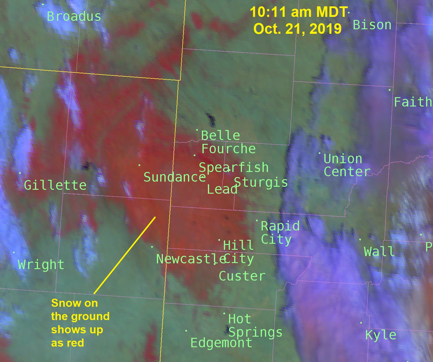 |
| Satellite image at 10:11 am on Monday, October 21, 2019 that shows snow on the ground (red areas), snow-free ground (green areas), and clouds (purple areas) |
 |
Snow Totals
Here are snowfall reports across the Black Hills area from the October 20, 2019 storm.
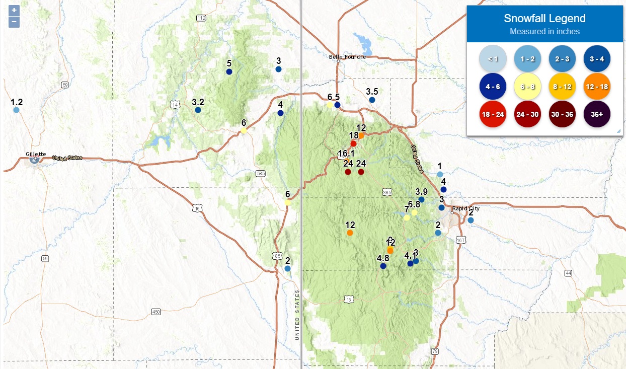 |
| Snowfall reports from Sunday, October 20, 2019 |
INCHES  LOCATION                 ST  COUNTY           TIME
 ------  -----------------------  --  --------------   -------
 24.00   5 SE CHEYENNE CROSSING   SD  LAWRENCE         0830 PM
 24.00   3 SW BROWNSVILLE         SD  LAWRENCE         0800 PM
 18.00   LEAD                     SD  LAWRENCE         1015 PM
 16.10   6 SSW LEAD               SD  LAWRENCE         0700 AM
 12.00   HILL CITY                SD  PENNINGTON       0942 PM
 12.00   3 SE DEERFIELD           SD  PENNINGTON       0845 PM
 12.00   DEADWOOD                 SD  LAWRENCE         0830 PM
 12.00   LEAD                     SD  LAWRENCE         0800 PM
 10.00   DEADWOOD                 SD  LAWRENCE         0637 PM
  9.00   HILL CITY                SD  PENNINGTON       0800 AM
  7.00   1 ESE PACTOLA RES        SD  PENNINGTON       0730 AM
  6.80   JOHNSON SIDING           SD  PENNINGTON       0350 AM
  6.00   2 W DWTN SPEARFISH       SD  LAWRENCE         0638 AM
  6.00   SUNDANCE                 WY  CROOK            0600 AM
  6.00   2 N FOUR CORNERS         WY  WESTON           0600 PM
  6.00   11 SW CHEYENNE CROSSING  SD  LAWRENCE         0137 PM
  6.00   4 SE DEERFIELD           SD  PENNINGTON       1105 AM
  5.00   DWTN SPEARFISH           SD  LAWRENCE         0700 AM
  5.00   5 S ALVA                 WY  CROOK            0501 PM
  5.00   DWTN SPEARFISH           SD  LAWRENCE         0448 PM
  5.00   CENTRAL CITY             SD  LAWRENCE         0139 PM
  4.80   4 SSW HILL CITY          SD  PENNINGTON       0700 AM
  4.10   MOUNT RUSHMORE           SD  PENNINGTON       1150 PM
  4.00   6 SW BEULAH              WY  CROOK            0700 AM
  4.00   7 NNW DWTN RAPID CITY    SD  MEADE            0700 AM
  4.00   ROCHFORD                 SD  PENNINGTON       0132 PM
  3.90   10 WNW DWTN RAPID CITY   SD  PENNINGTON       0700 AM
  3.50   4 NNW WHITEWOOD          SD  LAWRENCE         0700 AM
  3.20   13 WNW SUNDANCE          WY  CROOK            0700 AM
  3.00   3 WNW DWTN RAPID CITY    SD  PENNINGTON       0700 AM
  3.00   KEYSTONE                 SD  PENNINGTON       0545 PM
  3.00   ALADDIN                  WY  CROOK            0500 PM
  3.00   DWTN GILLETTE            WY  CAMPBELL         0144 PM
  3.00   5 NNW CUSTER             SD  CUSTER           0133 PM
  2.00   4 E NEWCASTLE            WY  WESTON           0700 AM
  2.00   5 ESE DWTN RAPID CITY    SD  PENNINGTON       0700 AM
  2.00   4 NE ROCKERVILLE         SD  PENNINGTON       0459 PM
  2.00   3 S REDIG                SD  HARDING          0316 PM
  2.00   4 N SILVER CITY          SD  PENNINGTON       0136 PM
  2.00   3 WSW SHERIDAN LAKE      SD  PENNINGTON       0134 PM
  1.20   14 NNW DWTN GILLETTE     WY  CAMPBELL         0700 AM
  1.00   5 E PIEDMONT             SD  MEADE            0700 AM
  1.00   2 ENE SUNDANCE           WY  CROOK            0140 PM
  1.00   BEULAH                   WY  CROOK            0140 PM
Radar Loop
Here is a radar loop from midnight Sunday, October 20 to 3:00 am MDT Monday, October 21. Blue areas indicate snow, and green areas indicate rain.
Wind Reports
The image below was created by interpolating observed wind gusts to a grid. It has been smoothed for display purposes, so some of the values might not reflect the actual values at that point. The actual reports are given below this image.
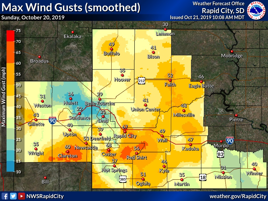 |
| Maximum wind gusts on Sunday, October 20, 2019 (note that the image has been smoothed) |
 SPEED   LOCATION                 ST  COUNTY           TIME
 ------  -----------------------  --  --------------   -------
 83.00   1 ESE CUSTER             SD  CUSTER           0509 PM
 68.00   2 SSW CUSTER             SD  CUSTER           0549 PM
 67.00   1 E DWTN RAPID CITY      SD  PENNINGTON       0505 PM
 64.00   3 WSW FAIRBURN           SD  CUSTER           0551 PM
 63.00   RAPID CITY ARPT          SD  PENNINGTON       0646 PM
 60.00   12 N ELLSWORTH AFB       SD  MEADE            0500 PM
 60.00   2 WSW O`NEIL PASS        SD  LAWRENCE         0350 PM
 60.00   7 NNE ELLSWORTH AFB      SD  MEADE            0330 PM
 60.00   25 ESE WRIGHT            WY  CAMPBELL         0205 PM
 58.00   3 NNW SCENIC             SD  PENNINGTON       0735 PM
 58.00   1 W WIND CAVE VISITORS   SD  CUSTER           0613 PM
 58.00   PRINGLE                  SD  CUSTER           0520 PM
 58.00   3 WSW FAIRBURN           SD  CUSTER           0506 PM
 55.00   1 E DWTN RAPID CITY      SD  PENNINGTON       0253 PM
 53.00   FOUR CORNERS             WY  WESTON           0236 PM
 |
Media use of NWS Web News Stories is encouraged! Please acknowledge the NWS as the source of any news information accessed from this site. |
|

