Dangerous heat will expand from the Gulf Coast into the Southern Plains and Desert Southwest through week's end. Additional extreme heat impacting the Pacific Northwest will shift to the northern Plains by the weekend. Tropical Storm Bertha is expected to continue to impact portions of the northwestern Gulf Coast from south central Louisiana to the upper Texas coast today. Read More >
Overview
|
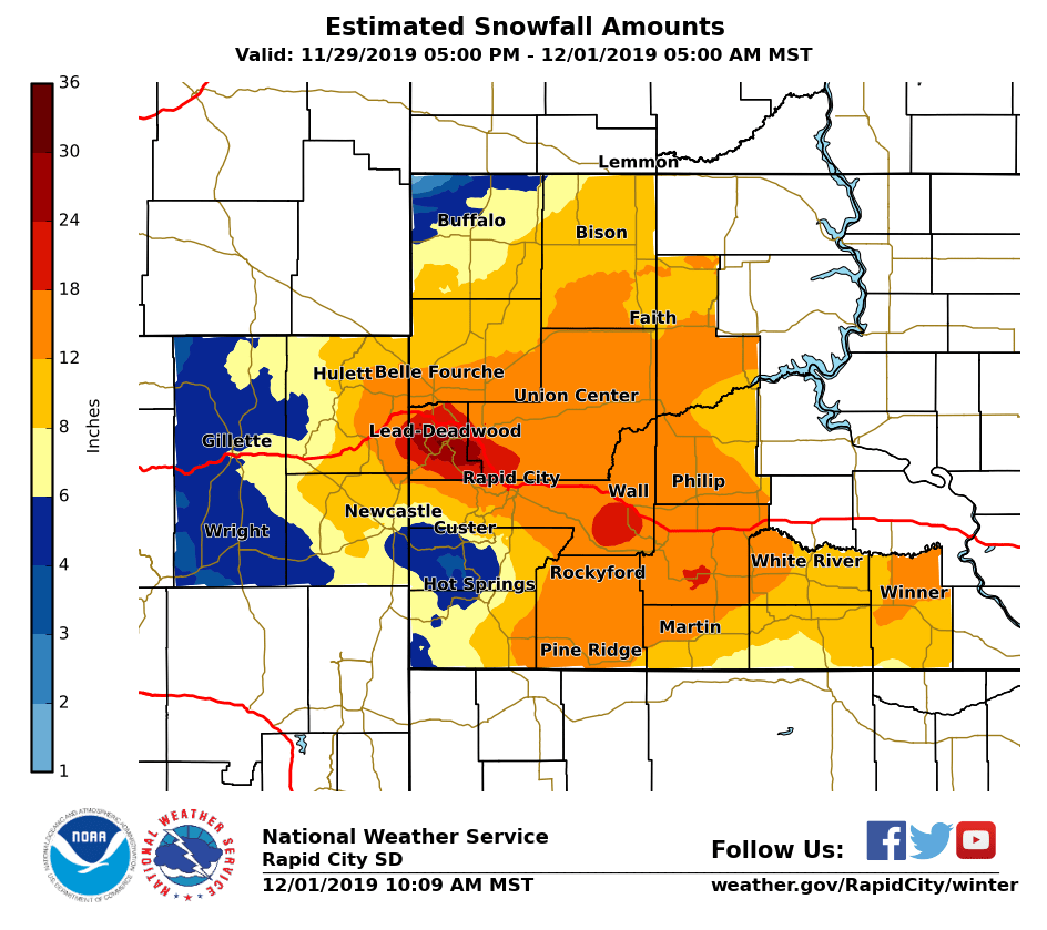
A strong storm system moved out of the central Rockies into the northern and central plains over the November 29-30, 2019 Thanksgiving weekend. The storm brought a large amount of moisture in the form of ice and snow, and very strong winds. Freezing drizzle on Thanksgiving and Black Friday transitioned to snow, which became heavy Friday night (November 29) and Saturday (November 30). Strong winds, with gusts of 45 to 60 mph, developed across northeastern Wyoming and western South Dakota Saturday morning. The winds, combined with snowfall amounts of 8 to 18 inches on the plains, created blizzard conditions. In the northern Black Hills, over two feet of snow was reported. Due to the wind direction, areas around and south of Custer, South Dakota only received 3 to 6 inches of snow.
|
|
Snowfall Totals
 |
||
| Preliminary Storm Total (click to enlarge) Note: These amounts will change as we get more reports! |
||
Snowfall Totals from November 29-30, 2019 |
||
Snow reports listed by amount

 INCHES  LOCATION                 ST  COUNTY           TIME
 ------  -----------------------  --  --------------   -------
 30.00   LEAD                     SD  LAWRENCE         0122 AM
                 3 TO 5 FT DRIFTS
 30.00   2 N CENTRAL CITY         SD  LAWRENCE         0345 PM
 25.00   2 SSE TERRY PEAK         SD  LAWRENCE         0700 AM
                 STORM TOTAL
 23.00   DWTN SPEARFISH           SD  LAWRENCE         0600 PM
 22.00   2 NW DWTN SPEARFISH      SD  LAWRENCE         0600 PM
 21.00   BLACK HAWK               SD  MEADE            0120 AM
 20.00   2 NNW SAINT ONGE         SD  LAWRENCE         0946 AM
 19.50   1 SSE DWTN SPEARFISH     SD  LAWRENCE         0800 AM
                 STORM TOTAL
 19.00   3 N TILFORD              SD  MEADE            0128 AM
                 STORM TOTAL 18 TO 20 INCHES
 19.00   12 WSW HEREFORD          SD  MEADE            0956 PM
                 WINDS STILL BLOWING, SNOW HAS STOPPED.
 19.00   1 NNW PIEDMONT           SD  MEADE            0900 PM
                 STORM TOTAL
 18.00   3 SSE NEMO               SD  LAWRENCE         1000 AM
 18.00   STURGIS                  SD  MEADE            1139 PM
                 STORM TOTAL BEST GUESS
 18.00   7 NNE ELLSWORTH AFB      SD  MEADE            0957 PM
                 DRIFTS 5 TO 6 FEET TALL.
 17.50   4 WNW RAPID CITY ARPT    SD  PENNINGTON       0140 AM
 17.50   2 SW DWTN RAPID CITY     SD  PENNINGTON       0745 PM
                 17 TO 18 INCHES OF SNOW
 17.10   JOHNSON SIDING           SD  PENNINGTON       0934 PM
 16.00   SUMMERSET                SD  MEADE            1130 PM
                 STORM TOTAL
 16.00   4 W DWTN RAPID CITY      SD  PENNINGTON       1128 PM
                 STORM TOTAL
 15.70   1 E DWTN RAPID CITY      SD  PENNINGTON       0141 AM
                 STORM TOTAL SNOWFALL
 15.00   2 WNW DWTN SPEARFISH     SD  LAWRENCE         0700 AM
                 STORM TOTAL
 15.00   3 NW RAPID CITY ARPT     SD  PENNINGTON       0113 AM
 14.50   3 SW DWTN RAPID CITY     SD  PENNINGTON       0420 PM
                 STORM TOTAL
 14.00   2 W OPAL                 SD  MEADE            0900 AM
                 STORM TOTAL, WINDS SUSTAINED AT 33 MPH AROUND
                 3 PM
 14.00   2 SW NORRIS              SD  MELLETTE         0700 AM
                 STORM TOTAL
 14.00   2 S DWTN RAPID CITY      SD  PENNINGTON       0700 AM
                 STORM TOTAL
 14.00   3 SSE DWTN RAPID CITY    SD  PENNINGTON       0119 AM
                 3 TO 4 FOOT DRIFTS
 14.00   SAINT ONGE               SD  LAWRENCE         1245 PM
 13.50   3 S BEULAH               WY  CROOK            0430 PM
 13.00   8 WNW USTA               SD  PERKINS          0700 AM
                 LOTS OF DRIFTING, WINDS STILL 20 TO 30 MPH
                 FROM THE NORTHWEST
 13.00   8 WNW USTA               SD  PERKINS          0700 AM
                 STORM TOTAL
 13.00   4 NE HULETT              WY  CROOK            0641 AM
                 STORM TOTAL
 13.00   4 NE ROCKERVILLE         SD  PENNINGTON       0550 PM
 13.00   5 ESE ELM SPRINGS        SD  MEADE            0500 PM
                 STILL SNOWING
 12.80   3 SE SAINT ONGE          SD  LAWRENCE         0700 AM
                 STORM TOTAL
 12.70   1 NNE SUNDANCE           WY  CROOK            0826 AM
                 STORM TOTAL
 12.00   5 S ALVA                 WY  CROOK            0830 AM
 12.00   4 SE VALE                SD  MEADE            0740 AM
                 STORM TOTAL, 3 TO 4 FT DRIFTS
 12.00   BELLE FOURCHE            SD  BUTTE            0739 AM
 12.00   4 NNE SUMMERSET          SD  MEADE            0700 AM
                 STORM TOTAL
 12.00   1 S BELLE FOURCHE        SD  BUTTE            0700 AM
                 STORM TOTAL
 12.00   NEWELL                   SD  BUTTE            0700 AM
 12.00   2 ENE WESTON             WY  CAMPBELL         0700 PM
                 24-HOUR SNOWFALL.
 12.00   9 WSW RED ELM            SD  ZIEBACH          0652 PM
                 BEST GUESS, LOTS OF BLOWING AND DRIFTING
 12.00   2 E STURGIS              SD  MEADE            0600 PM
                 24-HOUR SNOWFALL.
 12.00   1 W DWTN RAPID CITY      SD  PENNINGTON       1200 PM
 12.00   BEULAH                   WY  CROOK            1200 PM
 11.80   5 NE ROCKERVILLE         SD  PENNINGTON       0700 AM
                 STORM TOTAL
 11.00   VALE                     SD  BUTTE            1135 PM
                 STORM TOTAL 10 TO 12 INCHES
 11.00   5 NE MILESVILLE          SD  HAAKON           0600 PM
                 24-HOUR SNOWFALL.
 11.00   1 N HISEGA               SD  PENNINGTON       0300 PM
                 STILL SNOWING
 11.00   NISLAND                  SD  BUTTE            1230 PM
 11.00   1 SW DWTN SPEARFISH      SD  LAWRENCE         1200 PM
                 3.5 INCHES OF ADDITIONAL SNOW SINCE 9 AM.
 11.00   5 ESE NORRIS             SD  MELLETTE         1130 AM
 10.50   8 SE INTERIOR            SD  JACKSON          0400 PM
 10.40   3 NE HISEGA              SD  PENNINGTON       0700 AM
                 STORM TOTAL
 10.00   DUPREE                   SD  ZIEBACH          0430 PM
                 24-HOUR SNOWFALL.
 10.00   MEADOW                   SD  PERKINS          1130 AM
                 0.7 INCHES OF ICE UNDER THE 10 INCHES OF
                 SNOW.
 10.00   4 ESE DWTN RAPID CITY    SD  PENNINGTON       0957 AM
                 LOTS OF BLOWING AND DRIFTING SNOW. NEAR ZERO
                 VISIBILITY.
  9.50   8 SE MUD BUTTE           SD  MEADE            0700 AM
                 STORM TOTAL
  9.40   10 N ZEONA               SD  PERKINS          0700 AM
  9.00   8 E MARTIN               SD  BENNETT          0700 AM
                 STROM TOTAL
  9.00   SUNDANCE                 WY  CROOK            0600 AM
                 STORM TOTAL
  9.00   RED OWL                  SD  MEADE            0700 PM
                 24-HOUR SNOWFALL.
  9.00   4 S DEVILS TOWER         WY  CROOK            0600 PM
                 STORM TOTAL
  9.00   3 NE WHITEWOOD           SD  LAWRENCE         1130 AM
                 0.69" OF LIQUID. WINDS GUSTS OF 30 TO 35 MPH.
  9.00   2 W BOX ELDER            SD  PENNINGTON       0943 AM
  9.00   4 W DWTN RAPID CITY      SD  PENNINGTON       0930 AM
                 VISIBILITY LESS THAN 1/4 MILE, STILL SNOWING
  8.90   7 N WOOD                 SD  MELLETTE         0600 AM
                 STORM TOTAL
  8.00   1 W HOT SPRINGS          SD  FALL RIVER       0700 AM
  8.00   4 SE DWTN GILLETTE       WY  CAMPBELL         0400 PM
                 24-HOUR SNOWFALL.
  8.00   3 SW WHITEWOOD           SD  LAWRENCE         0955 AM
  7.70   1 NNE UPTON              WY  WESTON           0826 AM
                 STORM TOTAL
  7.00   DWTN GILLETTE            WY  CAMPBELL         0620 AM
                 STORM TOTAL
  6.00   8 WSW LODGEPOLE          SD  PERKINS          0800 AM
                 STORM TOTAL
  6.00   3 SSE HARDING            SD  HARDING          0800 AM
                 STORM TOTAL
  6.00   3 E NEWCASTLE            WY  WESTON           0700 AM
                 STORM TOTAL
  6.00   4 NNW CAMP CROOK         SD  HARDING          0230 PM
  6.00   2 SSW DWTN GILLETTE      WY  CAMPBELL         0949 AM
                 VISIBILITY LESS THAN A QUARTER MILE
  6.00   3 SE NEWCASTLE           WY  WESTON           0911 AM
                 WINDS ARE NOW BLOWING THE SNOW AROUND, NEAR
                 ZERO VISIBILITY
  5.00   6 N FAIRBURN             SD  CUSTER           0924 AM
  5.00   1 NNE EDGEMONT           SD  FALL RIVER       0600 AM
                 STORM TOTAL
  5.00   EDGEMONT                 SD  FALL RIVER       0800 PM
                 STORM TOTAL
  4.50   2 W CUSTER               SD  CUSTER           1142 PM
                 STORM TOTAL
  4.30   HILL CITY                SD  PENNINGTON       0700 AM
                 STORM TOTAL
  4.00   MOUNT RUSHMORE           SD  PENNINGTON       1200 AM
                 24-HOUR SNOWFALL. STORM TOTAL
  2.50   15 S BUFFALO             SD  HARDING          1200 PM
                 2-3 INCHES OF SNOW, NOT MUCH DRIFTING.
  2.00   12 SW CUSTER             SD  CUSTER           0659 PM
                 STORM TOTAL - IN DOWNSLOPE HOLE


Wind gust reports listed by speed (mph)

 SPEED   LOCATION                 ST  COUNTY           TIME
 ------  -----------------------  --  --------------   -------
 59.00   1 E DWTN RAPID CITY      SD  PENNINGTON       0141 AM
 53.00   ELLSWORTH AFB            SD  MEADE            0455 PM
 53.00   10 W EDGEMONT            SD  FALL RIVER       0257 PM
 51.00   3 NNW SCENIC             SD  PENNINGTON       0611 PM
 51.00   13 SSW REVA              SD  HARDING          0331 PM
|
Radar
| Radar imagery through Saturday, November 30th, showing the development and evolution of heavy snow across portions of western South Dakota, the Black Hills, and the Bear Lodge Mountains. |
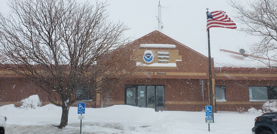
Photos
|
|||||||||||||||
 |
Media use of NWS Web News Stories is encouraged! Please acknowledge the NWS as the source of any news information accessed from this site. |
|