Dangerous and extreme heat will remain across portions of the southern U.S. this week. Heavy rainfall may bring significant flash flooding across portions of the Mid-Atlantic and Northeast through the night, and additional flash flooding concerns across New England on Wednesday. Monsoonal thunderstorms will bring a flash flood risk to the Four Corners region, especially in burn scar areas Read More >
Overview
|
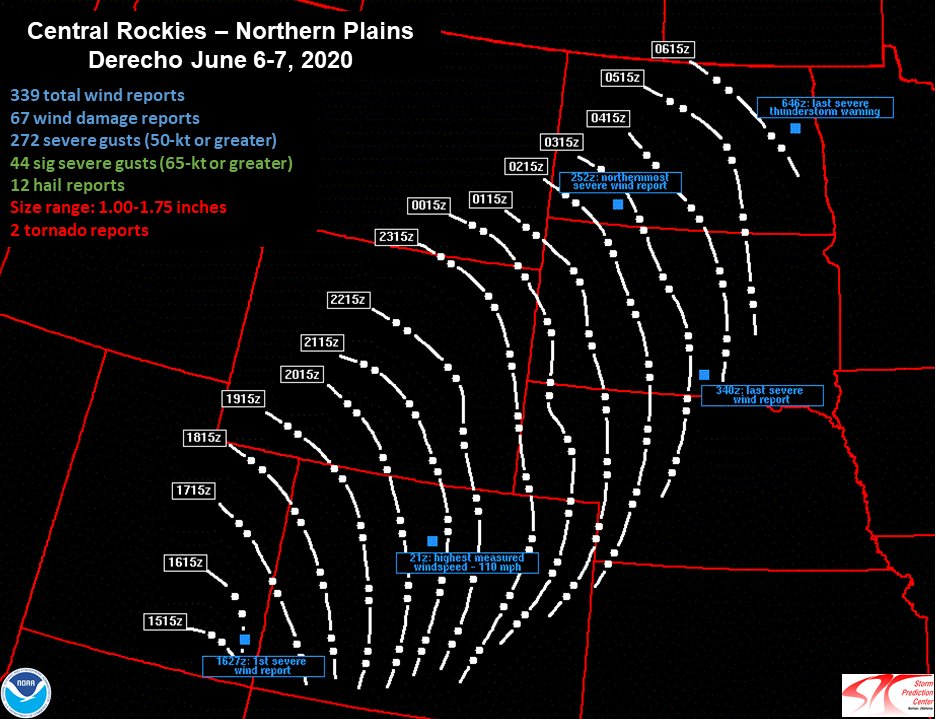
A powerful upper-level disturbance moving through the Rockies and Plains on June 6, 2020 sparked the development of a line of thunderstorms that brought widespread damaging winds from Utah and Colorado through northeastern Wyoming, western South Dakota, and southwestern North Dakota. Given the scope and intensity of the damaging winds, the storm system was classified as a "derecho" by the Storm Prediction Center. Derechos are characterized by a several hundred mile-long swath of persistent severe wind gusts (58 mph or greater), with embedded wind gusts that are considered significantly severe (75 mph or greater). There is more information about derechos here. This derecho rocked our county warning area during the afternoon and evening of June 6th, leading to over 100 reports of wind gusts of at least 58 mph and multiple reports of 80 to 95 mph winds. This derecho caused widespread damage, with 60 to 90+ mph winds reported. Sections of I-90 needed to be closed for a time due to construction site damage and vehicle rollovers. The derecho also produced at least two brief tornadoes. One was west of Billsburg, SD, in Haakon County. The other did damage to the Badlands/White River KOA campground southeast of Interior in Jackson County. The CIMMS Satellite Blog has additional details about this event: |
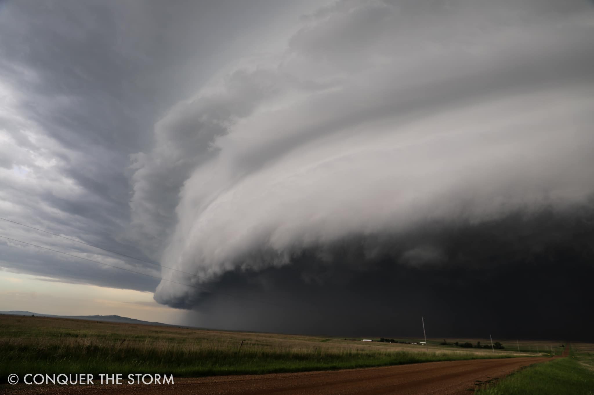 North of Belle Fourche, SD Courtesy Conquer The Storm |
|
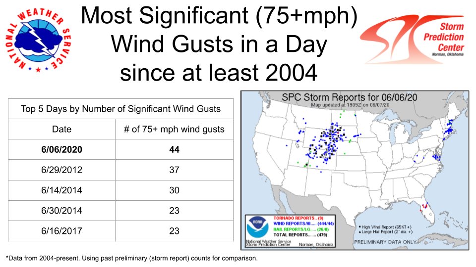
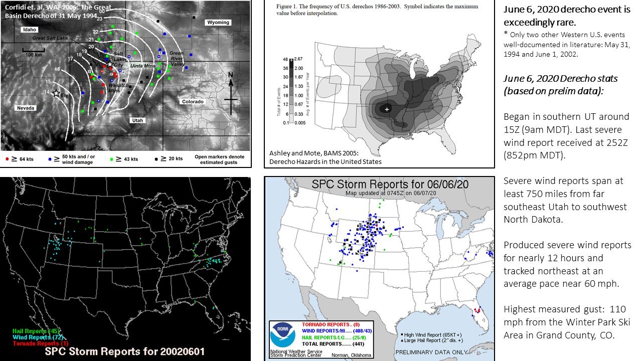
The Storm Prediction Center created a graphic with the most significant wind gusts in a day since 2004. June 6, 2020 is #1 with 44 reports. |
Courtesy Storm Prediction Center |
Photos & Video
Social Media - Note: If the video does not play, click on the post.
While running to keep in front of the shelf cloud of the June 6th derecho, I snapped this photo near Castle Rock, SD because I saw a suspicious lowering in the kink. No tornado, but this turned out pretty cool. @NWSRapidCity #sdwx pic.twitter.com/yUllxGJO8K
— Nick Nolte (@NickNolteWx) June 11, 2020
Shelf just East of Bison, SD around 8pm #sdwx @NWSRapidCity @NWSBismarck @ReedTimmerAccu @StormChaseGeeks pic.twitter.com/vERWqwjHO2
— Timothy Baca (@TimBacaWeather) June 7, 2020
I spent most of my day yesterday getting sunburned. Reluctantly, I got ahead of an incoming severe warned line north of Newell SD. Well, that derecho smacked into the warm front and did this insanity! What a day! #sdwx #wxtwitter #StormHour @spann @WeatherGoinWILD @NycStormChaser pic.twitter.com/0efkpQ5FI6
— Marcus Diaz (@TheTXWXchaser) June 7, 2020
Check out this funnel that formed as the squall line passed overhead! (Northeast of Sturgis)@NWSRapidCity #SDwx #severeweather #tornado pic.twitter.com/8hKzcxMimy
— Scott Nicholson (@MobileWxOffice) June 7, 2020
This bad boy in the Badlands made the day today! Incredibly fun day. No bust here! #sdwx #StormHour pic.twitter.com/8B4fjlcIMT
— Jim Tang (@wxmann) June 7, 2020
It was amazing to watch the structure of this MCS improve rapidly as it moved into a more unstable environment. These storms were not messing around. Awesome dynamics at play! #sdwx #beastmode pic.twitter.com/W3n6bSp6XJ
— John Homenuk (@jhomenuk) June 7, 2020
--- Andrew Guidarelli 🌹 (@a_guidarelli) June 7, 2020
Here is another view from more straight on...@StormHour @NWSRapidCity #sdwx #severeweather #thunderstorm #Shelfcloud pic.twitter.com/nnUMe6DGNm
— Scott Nicholson (@MobileWxOffice) June 7, 2020
Left and right sides of shelf cloud South of Buffalo, SD 6/6/20. #sdwx pic.twitter.com/ohjwtAqICn
— Phil Johnson (@Philstormpod) June 7, 2020
#sdwx Couple more of the intense shelf cloud over Faith, SD pic.twitter.com/XakPaVe1bZ
— Michael Snyder (@SeattleWXGuy) June 7, 2020
#sdwx #cows Was pretty mesmerizing watching this shelf cloud with QLCS circulations embedded in it come at us. The cows were looking to us for shelter I think! pic.twitter.com/6gRhaxvuvB
— Michael Snyder (@SeattleWXGuy) June 7, 2020
Here's a video of the shelf as it was moving through Wall, SD. It tried to produce a brief tornado at the beginning of the video with some good rotation but quickly disapparated. Also, it was really neat to see the wind direction in the grass it rolled through! #sdwx pic.twitter.com/fW0F47vA2V
— Hunter Fowkes (@StrmchsrHunterF) June 7, 2020
Brief mesovortex and attendant funnel north of Bear Butte, #SDwx @NWSRapidCity pic.twitter.com/Yg5goczEtP
— Cameron Nixon (@CameronJNixon) June 7, 2020
Here’s the full length time lapse from approaching squall to funnel. The evolution was awesome! @StormHour @NWSRapidCity #SDwx #Tornado #severeweather pic.twitter.com/kAqRASSdtA
— Scott Nicholson (@MobileWxOffice) June 7, 2020
 |
|||
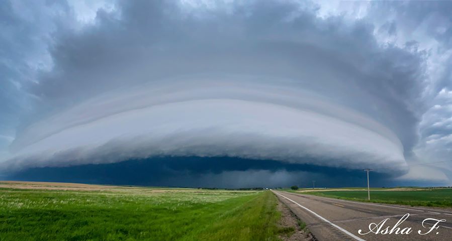
| Bison, SD Courtesy Asha F. |
Radar
0.5km Visible 1-Minute Imagery with Storm Reports
IR Satellite
Lightning
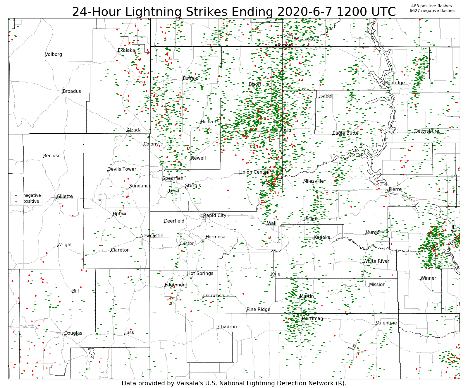
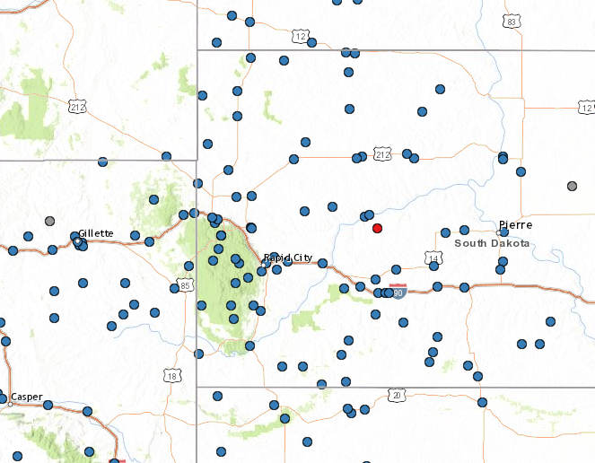
Storm Reports
The preliminary storm reports listed below are in descending
order and may not necessarily be the final storm reports.

Tstm wind reports listed by speed (mph)

 SPEED   LOCATION                 ST  COUNTY           TIME
 ------  -----------------------  --  --------------   -------
 94.00   13 NW BELLE FOURCHE      SD  BUTTE            0634 PM
 92.00   4 E CACTUS FLAT          SD  JACKSON          0759 PM
 85.00   FOUR CORNERS             WY  WESTON           0552 PM
 81.00   3 SE NEWELL              SD  BUTTE            0655 PM
 79.00   5 NE PORCUPINE           SD  OGLALA LAKOTA    0725 PM
 78.00   1 N BUFFALO              SD  HARDING          0733 PM
 78.00   1 NE ECHETA              WY  CAMPBELL         0522 PM
 78.00   16 WSW DWTN GILLETTE     WY  CAMPBELL         0502 PM
 77.00   8 N REDIG                SD  HARDING          0724 PM
 77.00   10 W EDGEMONT            SD  FALL RIVER       0534 PM
 76.00   9 W KADOKA               SD  JACKSON          0758 PM
 75.00   1 NNE FAITH              SD  MEADE            0825 PM
 75.00   8 W JEWEL CAVE           SD  CUSTER           0544 PM
 74.00   7 E WANBLEE              SD  JACKSON          0805 PM
 74.00   ELLSWORTH AFB            SD  MEADE            0639 PM
 74.00   DWTN SPEARFISH           SD  LAWRENCE         0615 PM
 74.00   2 SSE DWTN GILLETTE      WY  CAMPBELL         0515 PM
 74.00   5 NNW DWTN GILLETTE      WY  CAMPBELL         0513 PM
 74.00   25 ESE WRIGHT            WY  CAMPBELL         0505 PM
 72.00   2 SW BRIDGER             SD  ZIEBACH          0830 PM
 72.00   3 W FAITH                SD  MEADE            0815 PM
 72.00   4 E DWTN SPEARFISH       SD  LAWRENCE         0635 PM
 71.00   9 ENE BELVIDERE          SD  JACKSON          0834 PM
 71.00   12 WSW CASTLE ROCK       SD  BUTTE            0644 PM
 71.00   3 WSW FAIRBURN           SD  CUSTER           0634 PM
 70.00   1 NE MIDLAND             SD  HAAKON           0834 PM
 70.00   2 E COTTONWOOD           SD  JACKSON          0800 PM
 70.00   8 SE INTERIOR            SD  JACKSON          0753 PM
 70.00   3 SE DWTN SPEARFISH      SD  LAWRENCE         0711 PM
 70.00   4 SSW DWTN RAPID CITY    SD  PENNINGTON       0636 PM
 70.00   6 ESE CLARETON           WY  WESTON           0538 PM
 70.00   16 WSW DWTN GILLETTE     WY  CAMPBELL         0456 PM
 69.00   17 WSW WRIGHT            WY  CAMPBELL         0432 PM
 68.00   3 NW WASTA               SD  PENNINGTON       0754 PM
 68.00   8 N REDIG                SD  HARDING          0719 PM
 67.00   4 S DWTN RAPID CITY      SD  PENNINGTON       0630 PM
 67.00   1 E LEAD                 SD  LAWRENCE         0615 PM
 66.00   27 WNW CASTLE ROCK       SD  BUTTE            0656 PM
 66.00   4 N SILVER CITY          SD  LAWRENCE         0619 PM
 65.00   5 ESE NORRIS             SD  MELLETTE         0816 PM
 65.00   3 WSW FAIRBURN           SD  CUSTER           0624 PM
 65.00   19 SW UPTON              WY  WESTON           0515 PM
 64.00   2 W HAMILL               SD  TRIPP            0940 PM
 64.00   4 E CACTUS FLAT          SD  JACKSON          0754 PM
 64.00   9 SW BATESLAND           SD  OGLALA LAKOTA    0715 PM
 64.00   10 ESE PINE HAVEN        WY  CROOK            0542 PM
 64.00   3 E DWTN GILLETTE        WY  CAMPBELL         0515 PM
 64.00   16 WSW DWTN GILLETTE     WY  CAMPBELL         0512 PM
 64.00   13 NNE WRIGHT            WY  CAMPBELL         0502 PM
 64.00   SAVAGETON                WY  CAMPBELL         0437 PM
 63.00   5 WNW NEW UNDERWOOD      SD  PENNINGTON       0700 PM
 63.00   1 NNW NISLAND            SD  BUTTE            0640 PM
 63.00   HILL CITY                SD  PENNINGTON       0624 PM
 63.00   2 SSW CUSTER             SD  CUSTER           0602 PM
 62.00   3 ESE PINE RIDGE         SD  OGLALA LAKOTA    0709 PM
 62.00   4 SE DWTN GILLETTE       WY  CAMPBELL         0520 PM
 61.00   3 W LEMMON               SD  PERKINS          0834 PM
 61.00   PINE HAVEN               WY  CROOK            0534 PM
 60.00   SHADEHILL                SD  PERKINS          0845 PM
 60.00   7 ESE ROSEBUD            SD  TODD             0845 PM
 60.00   16 WNW MILESVILLE        SD  HAAKON           0820 PM
 60.00   10 ESE ZEONA             SD  PERKINS          0808 PM
 60.00   2 ENE WHITE OWL          SD  MEADE            0756 PM
 60.00   1 N CAMP CROOK           SD  HARDING          0735 PM
 60.00   KYLE                     SD  OGLALA LAKOTA    0733 PM
 60.00   1 WNW OGLALA             SD  OGLALA LAKOTA    0705 PM
 60.00   2 NE DWTN RAPID CITY     SD  PENNINGTON       0643 PM
 60.00   4 N SILVER CITY          SD  PENNINGTON       0620 PM
 60.00   6 W BEULAH               WY  CROOK            0615 PM
 60.00   9 W JEWEL CAVE           SD  CUSTER           0549 PM
 60.00   6 WNW NEWCASTLE          WY  WESTON           0535 PM
 60.00   7 WNW CLARETON           WY  WESTON           0515 PM
 60.00   4 N ROCHELLE             WY  WESTON           0508 PM
 59.00   11 SW PARMELEE           SD  TODD             0804 PM
 59.00   5 SW BROWNSVILLE         SD  LAWRENCE         0610 PM
 58.00   1 ENE MUD BUTTE          SD  MEADE            0839 PM
 58.00   6 W PARMELEE             SD  TODD             0828 PM
 58.00   3 W UNION CENTER         SD  MEADE            0719 PM
 58.00   12 E OELRICHS            SD  FALL RIVER       0639 PM
 58.00   4 NNE ANGOSTURA RES      SD  FALL RIVER       0615 PM
 58.00   6 W ROCHFORD             SD  PENNINGTON       0608 PM
 58.00   17 WSW WRIGHT            WY  CAMPBELL         0446 PM
 57.00   3 NW WASTA               SD  PENNINGTON       0719 PM
 56.00   7 NNE RALPH              SD  HARDING          0759 PM
 56.00   27 WNW CASTLE ROCK       SD  BUTTE            0756 PM
 55.00   13 NW BELLE FOURCHE      SD  BUTTE            0734 PM
 55.00   8 WNW FAIRBURN           SD  CUSTER           0718 PM
 55.00   ELLSWORTH AFB            SD  MEADE            0640 PM
 55.00   13 NNE WRIGHT            WY  CAMPBELL         0456 PM
 54.00   1 NE WINNER              SD  TRIPP            0939 PM
 54.00   4 SSE WITTEN             SD  TRIPP            0916 PM
 54.00   15 SSE MISSION           SD  TODD             0845 PM
 54.00   3 ESE LEMMON             SD  PERKINS          0835 PM
 54.00   2 ESE DWTN SPEARFISH     SD  LAWRENCE         0634 PM
 53.00   8 S WALL                 SD  PENNINGTON       0820 PM
 53.00   1 ENE MUD BUTTE          SD  MEADE            0734 PM
 53.00   8 N REDIG                SD  HARDING          0714 PM
 53.00   6 W ROCHFORD             SD  PENNINGTON       0708 PM
 53.00   17 WSW WRIGHT            WY  CAMPBELL         0452 PM
 52.00   3 E PHILIP               SD  HAAKON           0823 PM
 52.00   9 SW BATESLAND           SD  OGLALA LAKOTA    0810 PM
 52.00   1 NNW PIEDMONT           SD  MEADE            0630 PM
 52.00   PRINGLE                  SD  CUSTER           0559 PM
 51.00   7 ESE ROSEBUD            SD  TODD             0835 PM
 51.00   2 ENE SHERIDAN LAKE      SD  PENNINGTON       0635 PM
 51.00   7 E STRUGIS              SD  MEADE            0635 PM
 51.00   1 E LEAD                 SD  LAWRENCE         0625 PM
 51.00   2 NNW PACTOLA RES        SD  PENNINGTON       0619 PM
 51.00   PRINGLE                  SD  CUSTER           0609 PM
 51.00   8 W JEWEL CAVE           SD  CUSTER           0604 PM
 51.00   13 NNE WRIGHT            WY  CAMPBELL         0512 PM
 50.00   15 SSE MISSION           SD  TODD             0840 PM
 50.00   7 SSE MEADOW             SD  PERKINS          0829 PM
 50.00   4 N LUDLOW               SD  HARDING          0805 PM
 50.00   BEULAH                   WY  CROOK            0712 PM
Environment
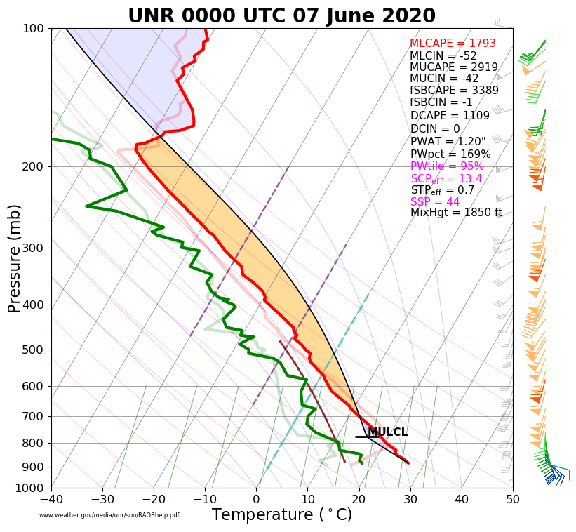
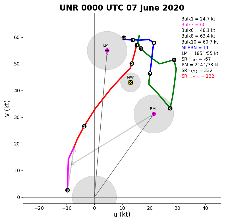
The environment supporting the derecho as it moved across western South Dakota was characterized by anomalously high moisture content and very strong vertical wind shear. The routine evening sounding released from the Rapid City Weather Forecast Office showed a precipitable water value of 1.20", which was the highest on record here for the evening of June 6th. Furthermore, the 60 knot magnitude of 0-3 km bulk shear was the highest on record for this date and time by over 10 knots.
The combination of anomalous moisture and vertical wind shear, coupled with large instability and strong forcing associated with an approaching intense upper-level disturbance, provided a volatile environment that supported the significant and widespread damaging wind event.
 |
 |
 |
| Figure 1: 00z June 7, 2020 KUNR Sounding | Figure 2: June 7, 2020 KUNR Hodograph | Figure 3: Historical Context Courtesy @WxLiz |
 |
Media use of NWS Web News Stories is encouraged! Please acknowledge the NWS as the source of any news information accessed from this site. |
|