Dangerous heat will expand from the Gulf Coast into the Southern Plains and Desert Southwest through week's end. Additional extreme heat impacting the Pacific Northwest will shift to the northern Plains by the weekend. Tropical Storm Bertha is expected to continue to impact portions of the northwestern Gulf Coast from south central Louisiana to the upper Texas coast today. Read More >
Overview
|
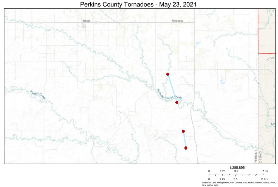
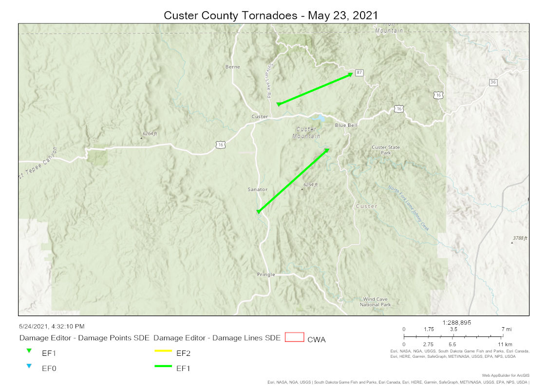
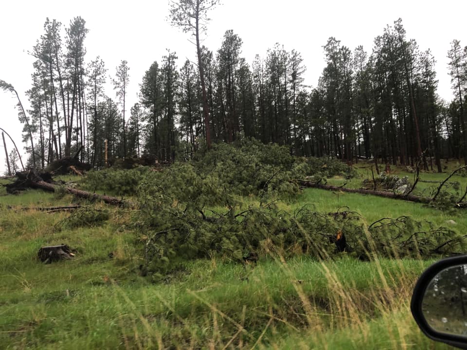
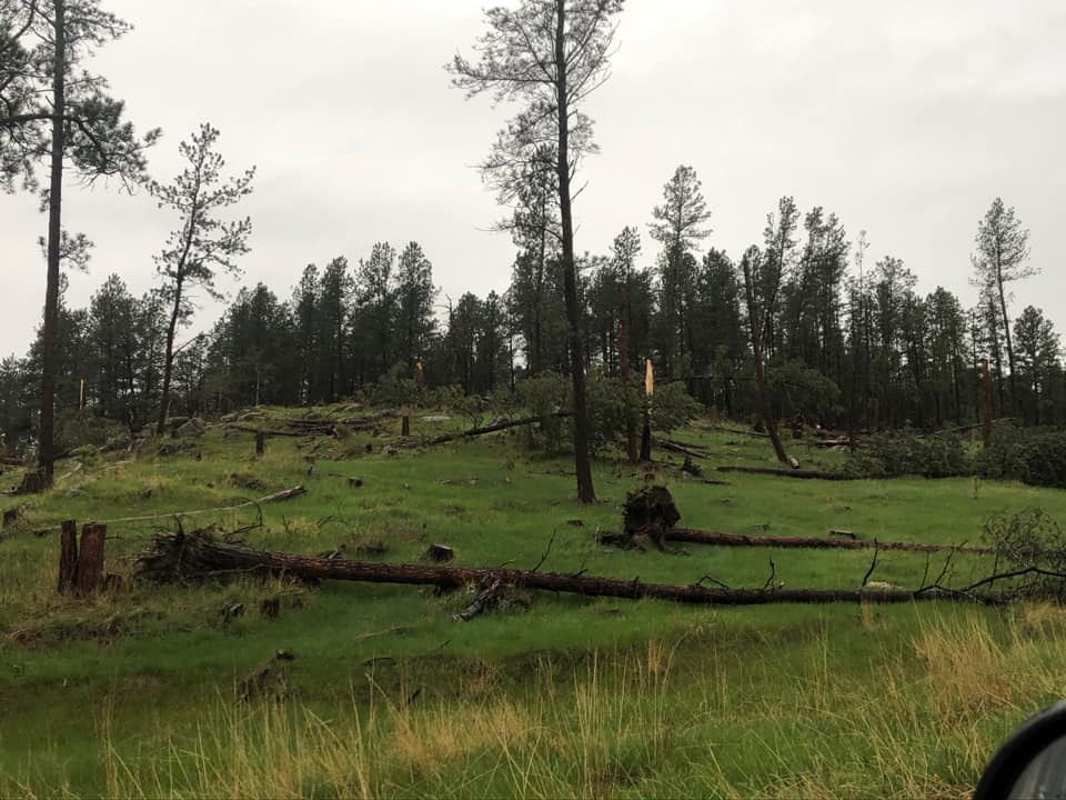
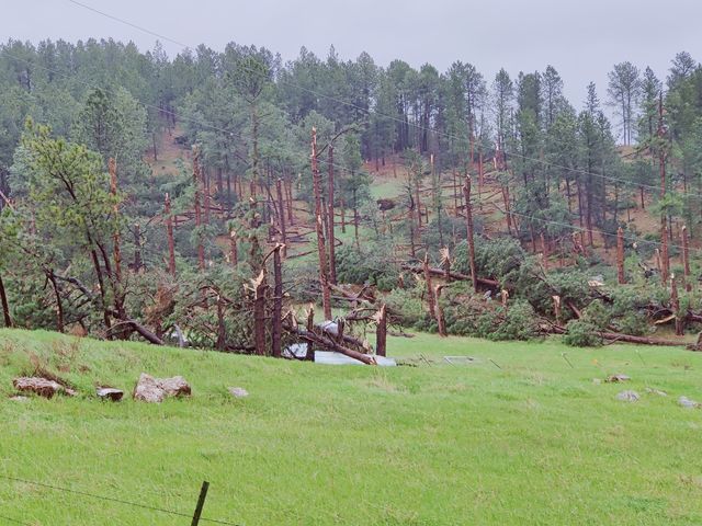
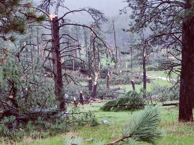
On May 23, 2021, a spring storm system brought numerous strong to severe thunderstorms to much of western and central South Dakota. These storms spawned at least four tornadoes and produced widespread wind gusts of 60 to 70 mph. Morning low clouds and fog across the western South Dakota plains and Black Hills gave way to an initial round of thunderstorms producing heavy rain and small hail by early afternoon. A second round of storms over the Black Hills produced two tornadoes in the Custer area, damaging straight-line winds, and hail up to half dollar size. As these storms moved eastward over the western South Dakota plains, the primary threat transitioned to straight-line winds. Several wind gusts of 60 to 70 mph were measured across the plains during the afternoon and evening hours. This line of storms continued to produce damaging winds near and east of the Missouri River into the night. East of this line of storms, supercells developed across the western South Dakota plains during the early and mid-afternoon hours. One supercell spawned two tornadoes in Perkins County. No damage was reported with either tornado as they traveled over mostly open land. |
 |
 |
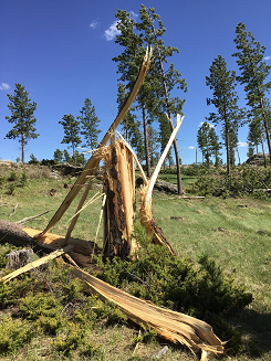
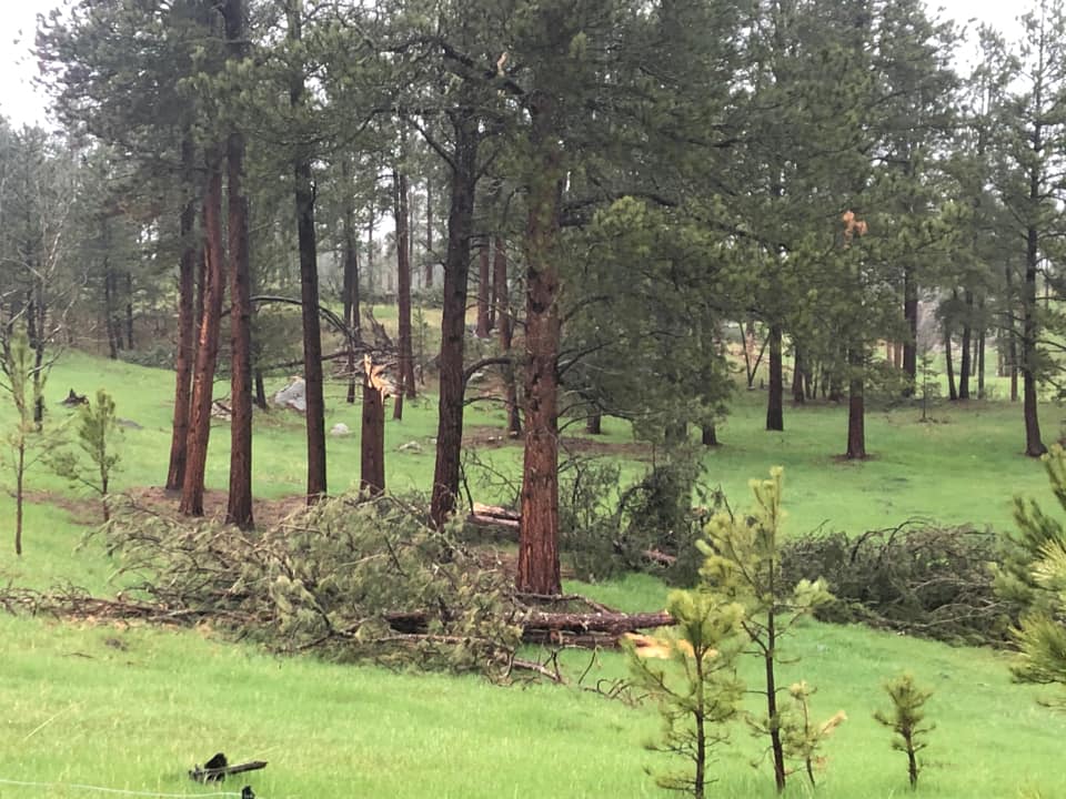
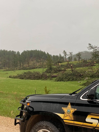
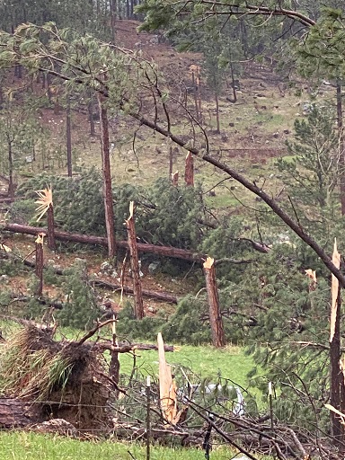
| Tree Damage from Custer County caused by Tornado 4 (photo from NWS Storm Survey) |
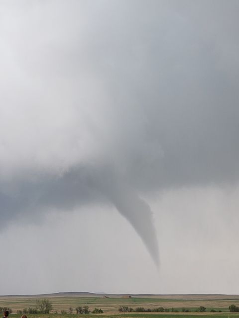
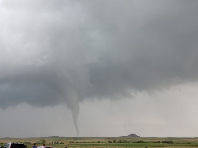
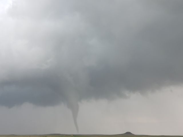
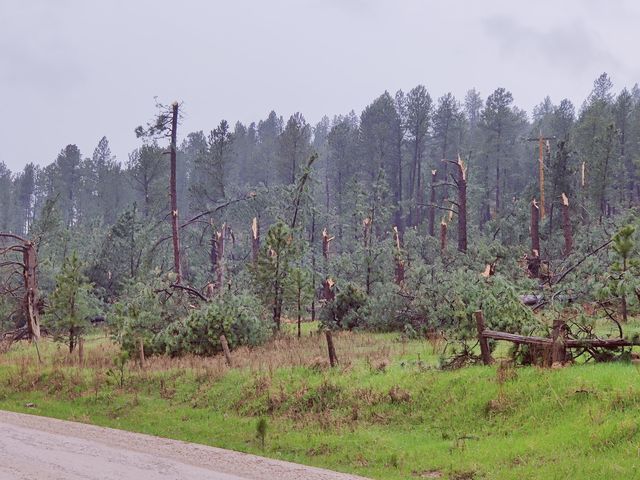
Perkins County Tornado 1 (photo by Janelle Uyeda) |
Tornadoes:
|
Tornado 1
|
||||||||||||||||
|
Tornado 2
|
||||||||||||||||
|
Tornado 3
|
||||||||||||||||
|
Tornado 4
|
||||||||||||||||
The Enhanced Fujita (EF) Scale classifies tornadoes into the following categories:
| EF0 Weak 65-85 mph |
EF1 Moderate 86-110 mph |
EF2 Significant 111-135 mph |
EF3 Severe 136-165 mph |
EF4 Extreme 166-200 mph |
EF5 Catastrophic 200+ mph |
 |
|||||
Photos & Video
 |
 |
| Perkins County Tornado 1 (photos by Janelle Uyeda) |
|
 |
 |
 |
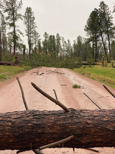
| 3 miles east of Custer (photos by Matt Selena Spring) |
||
 |
 |
 |
 |
| 4 miles south of Custer along Sidney Rd (photos by Brandon Zapp) |
|||
 |
 |
 |
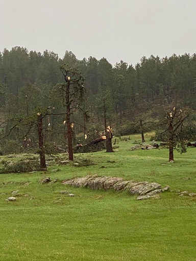 |
| Southeast of Custer (photos by Custer County Sheriff) |
|||
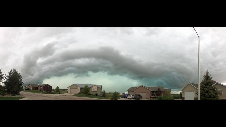 |
| Line of storms approaching Box Elder (photo by Amanda Breann) |
Radar
| Radar imagery from noon MDT through 10 PM MDT on May 23, 2021 |
Storm Reports
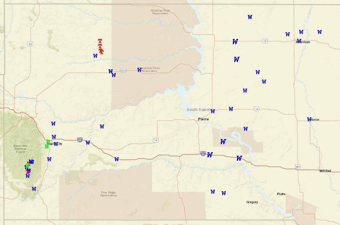 |
| Preliminary local storm reports from May 23, 2021 into early May 24, 2021. Red "T"s, blue "W"s, and green "H"s represent tornado, severe wind (58 mph or greater), and severe hail (1" or larger) reports. Italic blue "W"s show significant severe wind (75 mph or greater) reports. (Image courtesy of the Storm Prediction Center) |
The storm reports listed below are in descending order and may not
necessarily be the final storm reports.

Hail reports listed by size (inches)

 SIZE    LOCATION                 ST  COUNTY           TIME
 ------  -----------------------  --  --------------   -------
  1.25   1 SSW CUSTER             SD  CUSTER           0402 PM
  1.00   1 E DWTN RAPID CITY      SD  PENNINGTON       0458 PM
  1.00   4 S DWTN RAPID CITY      SD  PENNINGTON       0447 PM
  0.75   1 ENE CUSTER             SD  CUSTER           0408 PM


Thunderstorm wind reports listed by speed (mph)

 SPEED   LOCATION                 ST  COUNTY           TIME
 ------  -----------------------  --  --------------   -------
 70.00   WASTA                    SD  PENNINGTON       0540 PM
 68.00   2 SSW CUSTER             SD  CUSTER           0405 PM
 66.00   1 NNE FAITH              SD  MEADE            0656 PM
 66.00   1 NNE FAITH              SD  MEADE            0640 PM
 62.00   4 SSE WITTEN             SD  TRIPP            0845 PM
 62.00   CACTUS FLAT              SD  JACKSON          0559 PM
 60.00   WINNER                   SD  TRIPP            0900 PM
                 POWER IS OUT IN TOWN
 60.00   10 WSW RED ELM           SD  ZIEBACH          0650 PM
 60.00   3 NNE CREIGHTON          SD  PENNINGTON       0605 PM
                 PEA TO DIME SIZED HAIL
 60.00   12 WSW HEREFORD          SD  MEADE            0510 PM
 60.00   PRINGLE                  SD  CUSTER           0400 PM
 60.00   8 WNW USTA               SD  PERKINS          0335 PM
 59.00   HOT SPRINGS              SD  FALL RIVER       0341 PM
 58.00   RAPID CITY ARPT          SD  PENNINGTON       0455 PM
 58.00   ELLSWORTH AFB            SD  MEADE            0453 PM
 50.00   3 N JOHNSON SIDING       SD  PENNINGTON       0445 PM
                 PEA SIZED HAIL AND OVER AN INCH OF RAIN SO
                 FAR.


Rain amounts (inches)

 AMOUNT  LOCATION                 ST  COUNTY           TIME
 ------  -----------------------  --  --------------   -------
  2.89   9 W BISON                SD  PERKINS          0700 AM
                 24-HOUR RAINFALL.
  1.91   14 S REVA                SD  HARDING          0625 AM
                 4 DAY TOTAL... 0.25 INCHES ON THURSDAY, 0.46
                 INCHES ON FRIDAY, AND 1.20 INCHES OVER THE
                 WEEKEND
  1.90   MOUNT RUSHMORE           SD  PENNINGTON       1200 AM
                 STORM TOTAL
  1.87   7 W RAPID CITY           SD  PENNINGTON       0700 AM
                 24-HOUR RAINFALL.
  1.65   1 NNW PIEDMONT           SD  MEADE            1200 AM
                 STORM TOTAL
  1.64   10 WNW RAPID CITY        SD  PENNINGTON       0637 AM
                 24-HOUR RAINFALL.
  1.56   14 NW EDGEMONT           SD  FALL RIVER       0800 AM
                 24-HOUR RAINFALL.
  1.48   5 E PIEDMONT             SD  MEADE            0600 AM
                 24-HOUR RAINFALL.
  1.36   6 SSW LEAD               SD  LAWRENCE         0700 AM
                 24-HOUR RAINFALL.
  1.35   RAPID CITY ARPT          SD  PENNINGTON       1200 AM
                 24 HOUR TOTAL
  1.33   6 NNE RAPID CITY         SD  MEADE            0700 AM
                 24-HOUR RAINFALL.
  1.32   8 NNE BOX ELDER          SD  MEADE            0700 AM
                 24-HOUR RAINFALL.
  1.28   1 ESE PACTOLA RES        SD  PENNINGTON       0800 AM
                 STORM TOTAL
  1.27   2 NE BOX ELDER           SD  PENNINGTON       0800 AM
                 24-HOUR RAINFALL.
  1.27   12 WSW HEREFORD          SD  MEADE            1000 PM
                 STORM TOTAL RAINFALL
  1.23   3 WNW RAPID CITY         SD  PENNINGTON       0700 AM
                 24-HOUR RAINFALL.
  1.20   5 ENE CUSTER             SD  CUSTER           0600 AM
                 24-HOUR RAINFALL.
  1.16   TILFORD                  SD  MEADE            0700 AM
                 24-HOUR RAINFALL.
  1.15   3 WNW RAPID CITY         SD  PENNINGTON       0700 AM
                 24-HOUR RAINFALL.
  1.15   4 S RAPID CITY           SD  PENNINGTON       0700 AM
                 24-HOUR RAINFALL.
  1.12   11 NW UNION CENTER       SD  MEADE            0605 AM
                 24-HOUR RAINFALL.
  1.11   4 W HOT SPRINGS          SD  FALL RIVER       0700 AM
                 24-HOUR RAINFALL.
  1.11   1 E DWTN RAPID CITY      SD  PENNINGTON       1200 AM
                 24 HOUR STORM TOTAL
  1.10   4 NE RAPID CITY          SD  PENNINGTON       0600 AM
                 24-HOUR RAINFALL.
  1.04   LEAD                     SD  LAWRENCE         0900 AM
                 STORM TOTAL
  1.04   1 W NEWCASTLE            WY  WESTON           0519 AM
                 24-HOUR RAINFALL.
  1.03   4 NNW WHITEWOOD          SD  LAWRENCE         0530 AM
                 24-HOUR RAINFALL.
  1.00   HOT SPRINGS              SD  FALL RIVER       0700 AM
                 24-HOUR RAINFALL.
  0.90   10 WSW RED ELM           SD  ZIEBACH          0950 PM
                 6-HOUR RAINFALL.
  0.50   11 ENE WANBLEE           SD  JACKSON          1004 PM
                 12-HOUR RAINFALL.
Environment
From the morning of May 23, 2021 into the afternoon, a strong mid-to-upper-level trough and associated upper-level jet streak approached the area from the west. These features supported the strengthening of a surface cyclone over the central Rockies, allowing a warm front to lift northward across western South Dakota and leading to a moderately unstable, strongly sheared environment favorable for severe weather.
 |
 |
 |
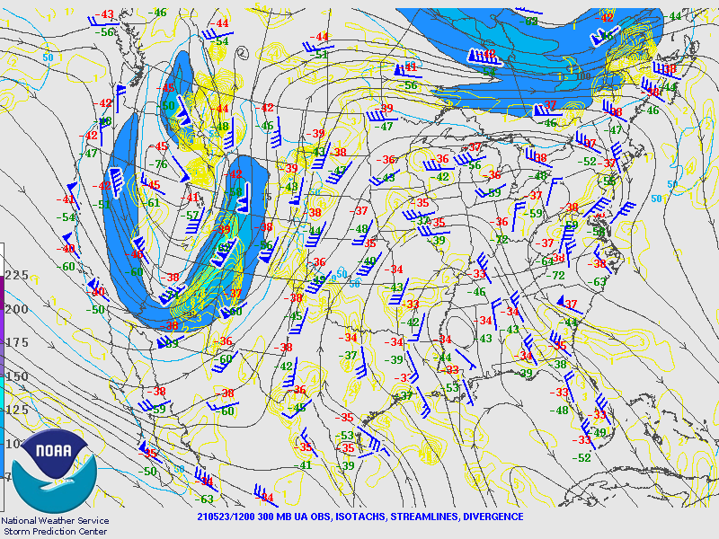
| Figure 1: 12z (6 AM MDT) 5/23/21 300 mb (upper-level) observations showing wind speeds, streamlines, and divergence. Note the trough axis west of the Four Corners region and jet streak extending from AZ northward into WY. (Image courtesy Storm Prediction Center) |
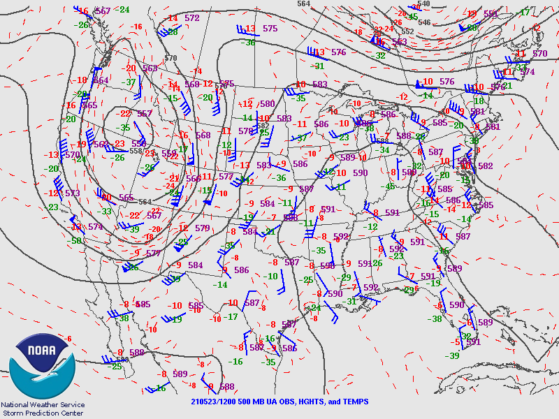
Figure 2: 12z (6 AM MDT) 5/23/21 500 mb (midlevel) observations showing lines of constant height, wind barbs, and temperatures. A midlevel low center is evident near the ID/NV/WA border. (Image courtesy Storm Prediction Center) |
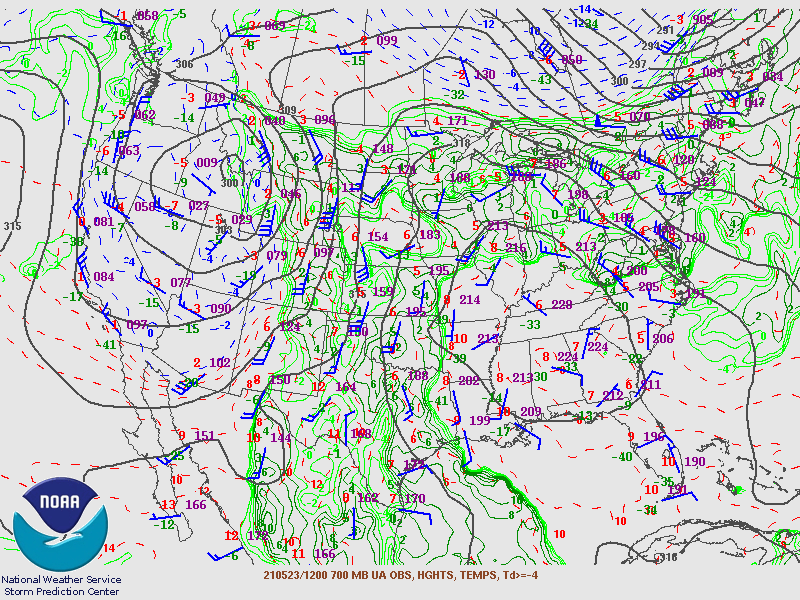
Figure 3: 12z (6 AM MDT) 5/23/21 700 mb (low-to-midlevel) observations showing lines of constant height, wind barbs, temperatures, and dew points. (Image courtesy Storm Prediction Center) |
 |
 |
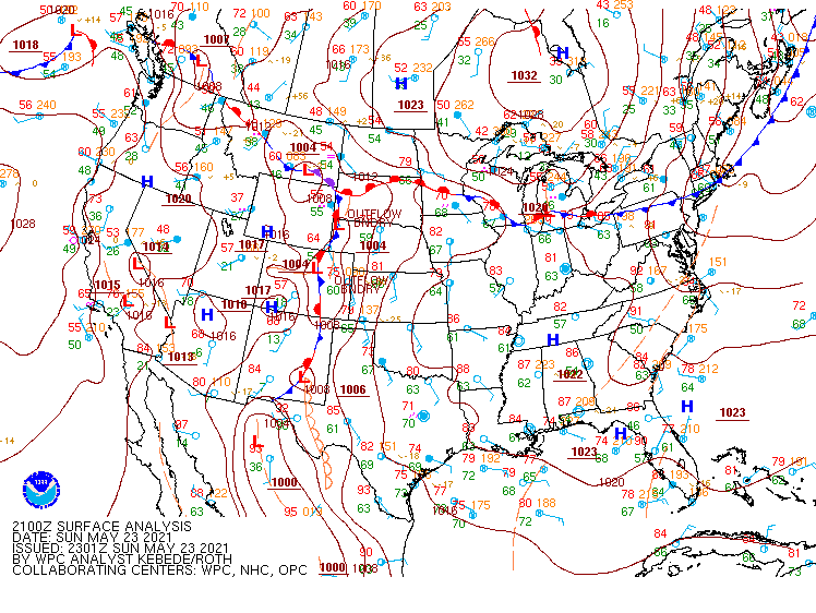 |
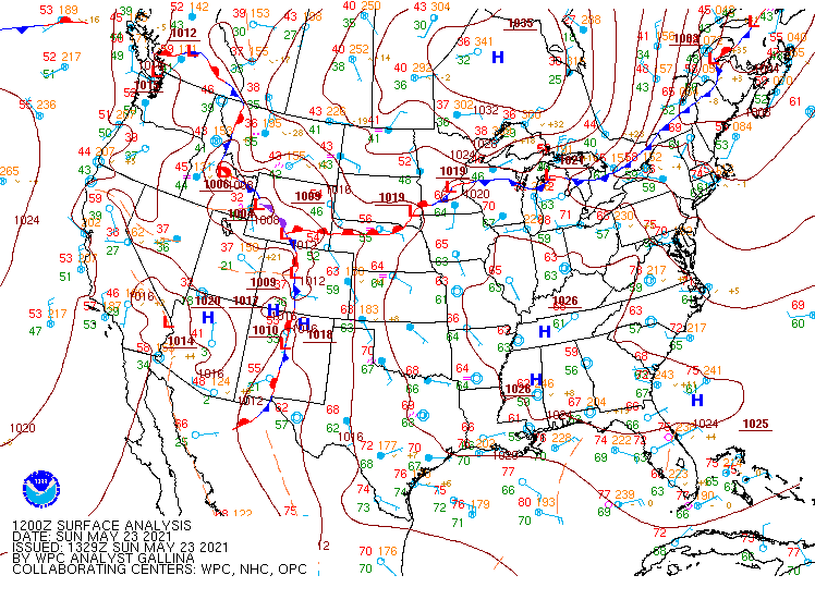
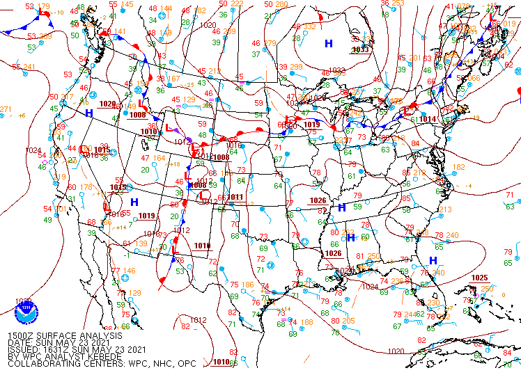
| Figure 4: 12z (6 AM MDT) 5/23/21 surface analysis courtesy of the Weather Prediction Center. Note warm front south of the NE/SD border and low pressure center over south central WY. | Figure 5: 15z (9 AM MDT) 5/23/21 surface analysis courtesy of the Weather Prediction Center. Note that the warm front has lifted northward as the surface low has moved eastward. | Figure 6: 21z (3 PM MDT) 5/23/21 surface analysis courtesy of the Weather Prediction Center. The warm front has now lifted north of the Black Hills as the surface low has moved near the NE/SD/WY border. |
 |
 |
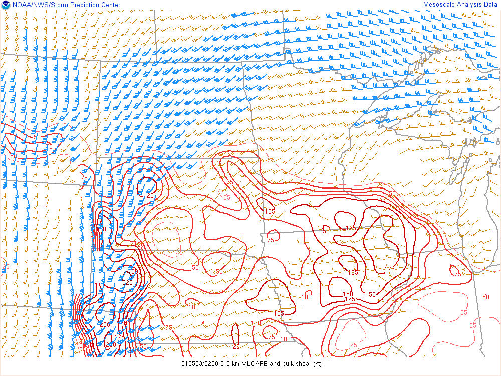 |
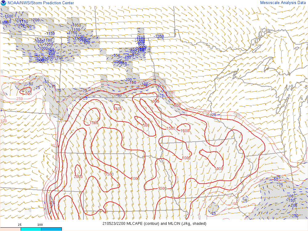
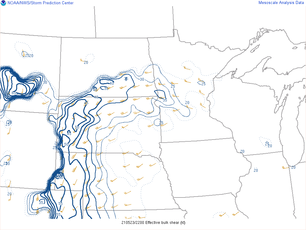
| Figure 7. Mixed-layer convective available potential energy (MLCAPE) and convective inhibition (CIN) from the SPC mesoanalysis page valid at 22z (4 PM MDT) 5/23/21. This plot reveals a moderately unstable environment across much of the region, with MLCAPE values of 1,000-2,000 J/kg. | Figure 8: Effective-layer (based upon the expected storm depth) vertical shear from the SPC mesoanalysis page, valid at 22z (4 PM MDT) 5/23/21. Deep-layer shear magnitudes at this time, which was approximately the time when tornadoes occurred in Perkins and Custer counties, were strong (40-50 kt). | Figure 9: Combination plot from the SPC mesoanalysis showing 0-3 km CAPE and 0-3 km vertical wind shear vectors, valid at 22z (4 PM MDT) 5/23/21. These two parameters are useful in highlighting areas favorable for quasi-linear convective system (QLCS; aka squall line) tornadoes, such as those observed near Custer. Values of 0-3 km CAPE (100-150 J/kg) and 0-3 km shear (30-40 kt) are both considered supportive for the development of QLCS tornadoes. |
 |
Media use of NWS Web News Stories is encouraged! Please acknowledge the NWS as the source of any news information accessed from this site. |
|