
Dangerous heat will expand from the Gulf Coast into the Southern Plains and Desert Southwest through week's end. Additional extreme heat impacting the Pacific Northwest will shift to the northern Plains by the weekend. Tropical Storm Bertha is expected to continue to impact portions of the northwestern Gulf Coast from south central Louisiana to the upper Texas coast today. Read More >
Overview
A strong spring snowstorm brought blizzard conditions to Montana and North Dakota, as well as far northwestern South Dakota, on April 12-13, 2022. There was a very tight gradient of snowfall amounts, with around a foot of snow across the ND/SD border, to only 1 to 2 inches near Faith and Belle Fourche, and little to no snow accumulations farther south. What we didn't have in snow, however, we made up for in wind, with yet another multi-day high wind event across much of the area. Wind gusts were 60 to 70 mph. Snow finally ended on the 13th, but strong winds continued into the 14th.
Radar
Storm Reports
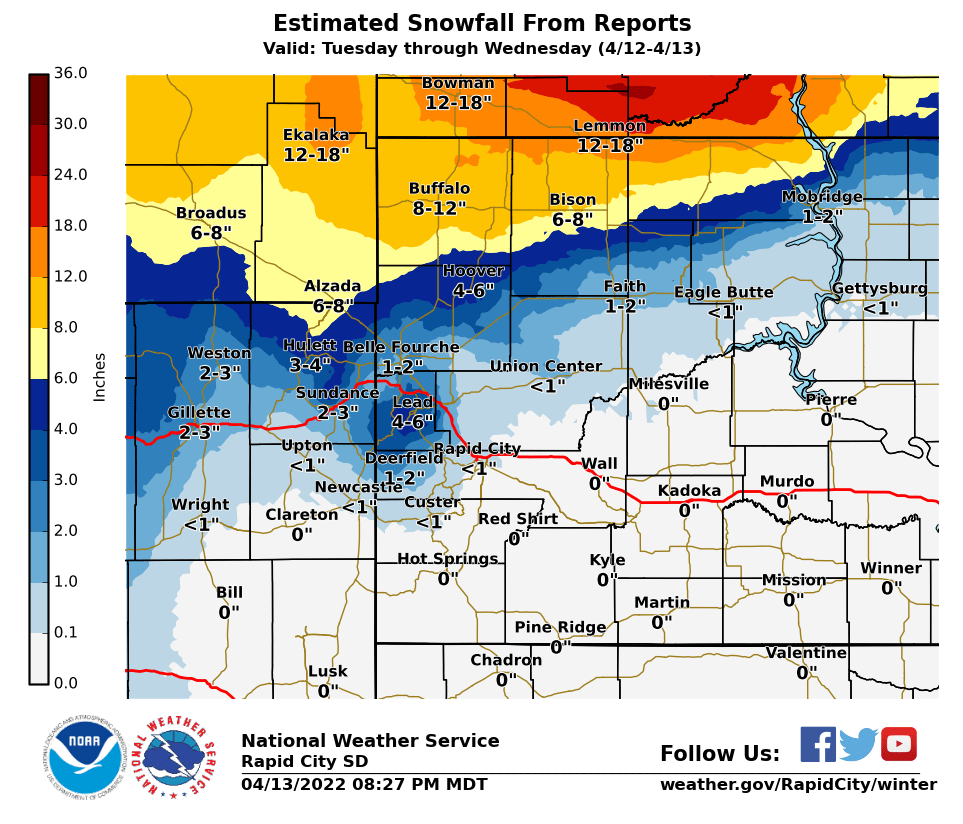
...PRELIMINARY SNOW TOTALS SORTED BY MAGNITUDE...

LOCATION                      SNOWFALL    COMMENTS
                               IN/S/

Buffalo SD                     12.0        748 PM 4/13/2022
2 SE Lodgepole SD              12.0        738 PM 4/13/2022
1 SE Ladner SD                 12.0        741 PM 4/13/2022
1 SW Shadehill SD              12.0        740 PM 4/13/2022
16 NE Hulett WY                 7.0        615 PM 4/12/2022
17 NW Belle Fourche Resv SD     3.5        801 PM 4/13/2022
Cheyenne Crossing SD            3.0        754 PM 4/13/2022
11 NNE Weston WY                1.5        700 AM 4/13/2022
2 WNW Dwtn Spearfish SD         1.0        700 AM 4/13/2022
8 WNW Usta SD                   1.0        445 PM 4/12/2022
8 SE Mud Butte SD               1.0        800 AM 4/13/2022
Lead SD                         1.0       1000 AM 4/13/2022
6 SW Beulah WY                  1.0        800 AM 4/13/2022


...MAXIMUM OBSERVED WINDS SORTED BY MAGNITUDE...

LOCATION                      MAX WIND    COMMENTS
                               MPH

1 WSW Red Elm SD                 72        232 PM 4/13/2022
1 NE Midland SD                  70       1215 PM 4/13/2022
3 W Union Center SD              70        219 PM 4/13/2022
1 NNE Faith SD                   68        348 PM 4/13/2022
4 E Cactus Flat SD               67        712 PM 4/13/2022
3 E Philip SD                    67        333 PM 4/13/2022
9 ENE Belvidere SD               65        506 PM 4/13/2022
3 NW Wasta SD                    65        512 PM 4/13/2022
7 NNE Ralph SD                   64        247 PM 4/13/2022
1 ENE Mud Butte SD               64        500 PM 4/13/2022
7 E Sturgis SD                   64        520 PM 4/13/2022
4 N Ludlow SD                    64        302 PM 4/13/2022
1 N Buffalo SD                   64        140 PM 4/13/2022
4 SSE Witten SD                  63        152 PM 4/13/2022
15 SSE Mission SD                62        745 PM 4/12/2022
3 NNW Scenic SD                  62        556 PM 4/12/2022
7 E Wanblee SD                   62        748 PM 4/13/2022
2 SW Bridger SD                  61        232 PM 4/13/2022
1 NE Winner SD                   59        222 PM 4/13/2022
9 SW Batesland SD                59        152 PM 4/13/2022
12 E Oelrichs SD                 59        305 PM 4/13/2022
8 S Wall SD                      59        320 PM 4/13/2022
Rapid City Arpt SD               59        354 PM 4/12/2022
1 E Lead SD                      59       1210 PM 4/13/2022
7 WSW Hoover SD                  58        247 PM 4/13/2022
5 WNW New Underwood SD           57        322 PM 4/13/2022
7 SSE Meadow SD                  57        145 PM 4/13/2022
10 W Edgemont SD                 57       1214 PM 4/13/2022
2 E Cottonwood SD                57        615 PM 4/13/2022
Wewela SD                        57       1030 PM 4/12/2022
3 ESE Pine Ridge SD              55       1218 PM 4/13/2022
13 SSW Reva SD                   55       1237 PM 4/12/2022
13 NW Belle Fourche SD           55        331 PM 4/13/2022
8 SSW Folsom SD                  55        338 PM 4/12/2022
12 WSW Castle Rock SD            55       1255 PM 4/13/2022
Pringle SD                       55       1231 PM 4/13/2022
3 W Lemmon SD                    55        234 PM 4/13/2022
3 ESE Lemmon SD                  54        355 PM 4/13/2022
Wasta SD                         54       1130 AM 4/13/2022
27 WNW Castle Rock SD            54        456 PM 4/13/2022
7 S Shadehill SD                 53        208 PM 4/13/2022
8 W Jewel Cave SD                53        201 PM 4/13/2022
1 E Dwtn Rapid City SD           52        428 PM 4/13/2022
Bison SD                         52        120 PM 4/13/2022
2 SSW Custer SD                  52        419 PM 4/13/2022
4 E Dwtn Spearfish SD            52        455 PM 4/13/2022
Ellsworth AFB SD                 51        245 PM 4/12/2022
1 NNW Nisland SD                 51        410 PM 4/13/2022
6 WSW Opal SD                    50        230 PM 4/13/2022
1 W Box Elder SD                 50        446 PM 4/12/2022
3 SE Dwtn Spearfish SD           50       1211 PM 4/13/2022
4 N Silver City SD               50        152 PM 4/13/2022
11 SW Parmelee SD                50        729 PM 4/12/2022
 |
Media use of NWS Web News Stories is encouraged! Please acknowledge the NWS as the source of any news information accessed from this site. |
|

