
A prolonged, dangerous heat wave will persist through the Independence Day weekend across the Ohio Valley, Mid-South, and East Coast. Severe thunderstorms are expected to produce damaging wind gusts from the Upper Ohio Valley into the Mid Atlantic, and across the central Great Plains this afternoon and evening. Large hail and heavy rain is also possible across the Great Plains. Read More >
Overview
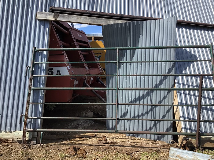
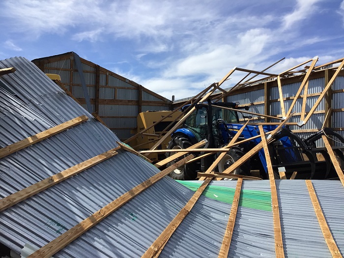
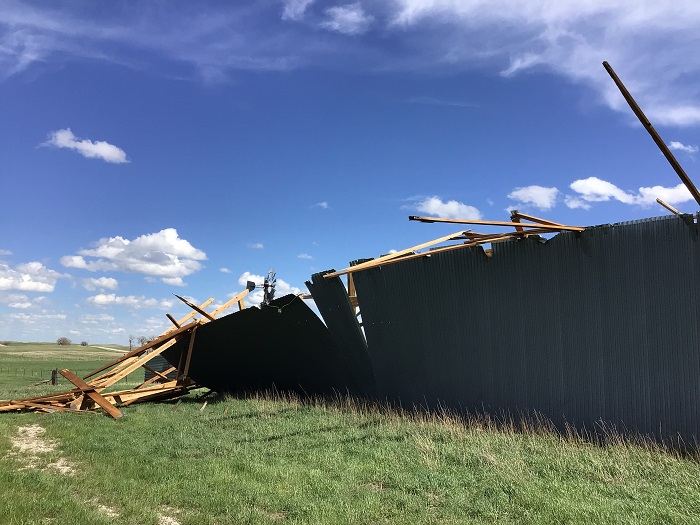
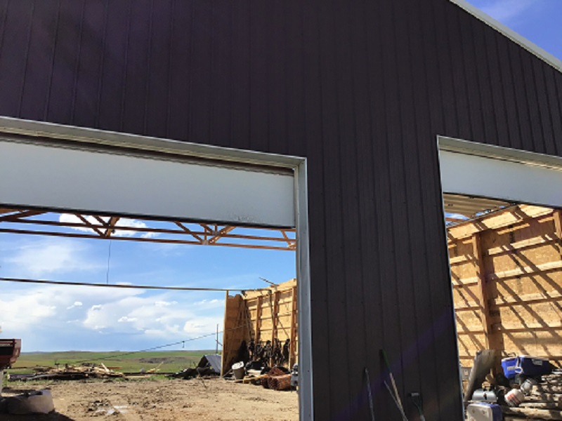
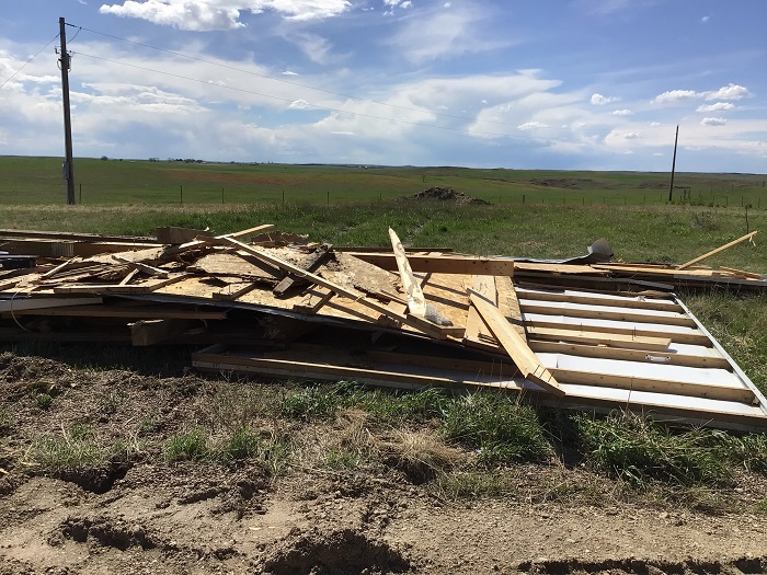
Late in the evening on Wednesday, May 11, thunderstorms moved across south central South Dakota, while others developed over the Black Hills and moved northeast overnight. Portions of the western South Dakota plains were hit by multiple thunderstorms overnight, which brought damaging winds and large hail. The most severe wind damage occurred in the Red Owl area, where several outbuildings were substantially damaged or completely destroyed. A damage survey determined the damage was caused by very strong straight-line winds, not a tornado. While the highest measured wind gust was 76 mph, the structure damage indicated wind gusts were higher than 80 mph.
Photos & Video
Header
 |
 |
 |
| Machine shed damage near Red Owl |
Machine shed damage near Red Owl |
Machine shed damage near Red Owl |
 |
 |
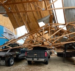 |
| Machine shed damage near Red Owl |
Machine shed damage near Red Owl |
Machine shed damage near Red Owl (C. Matt) |
Radar
Storm Reports
PUBLIC INFORMATION STATEMENT
NATIONAL WEATHER SERVICE RAPID CITY SD
930 AM MDT SAT MAY 14 2022

THE FOLLOWING ARE UNOFFICIAL OBSERVATIONS FROM THUNDERSTORMS THAT
OCCURRED LATE MAY 11 AND EARLY MAY 12

...24 HOUR RAINFALL...

LOCATION              24 HOUR      TIME/DATE  COMMENTS
                     RAINFALL       MEASURED
                     (INCHES)

SOUTH DAKOTA

...MEADE COUNTY...
  6 SSW FAIRPOINT        1.21   521 AM  5/12  COCORAHS
  1 NNE FAITH            1.05   714 AM  5/12  ASOS
  1 NNW PIEDMONT         0.99   714 AM  5/12  NWS EMPLOYEE
  4 NNE SUMMERSET        0.76   600 AM  5/12  COCORAHS

...ZIEBACH COUNTY...
  10 WSW RED ELM         1.10   645 AM  5/12  SMALL HAIL.


...WIND DAMAGE REPORTS...

LOCATION                      DAMAGE

ENNING SD                     2 INCH TREE BRANCHES DOWN
2 NW RED OWL SD               ROOF BLOWN OFF SHOP, DOORS
                              BLOWN DOWN
2 SE RED OWL SD               LONGBOX PICKUP AND ATTACHED
                              HORSE TRAILER TIPPED OVER,
                              VERY STURDY METAL FEED BUNKS
                              MOVED 100 YDS, METAL TROUGH
                              PICKED UP AND STUCK IN METAL
                              FENCE
3 SSE THUNDER BUTTE SD        BROKEN WINDOWS
7 ENE RED OWL SD              ROOF BLOWN OFF SHED, GRAIN BIN
                              MOVED 1/4 MI, TANK MOVED OFF
                              CEMENT TRUCK 1/4 MI
3 NE RED OWL SD               ROOF BLOWN OFF AND SOME WALLS
                              COLLAPSED ON A BARN
4 ENE RED OWL SD              ROOF TORN OFF BARN


...MAXIMUM OBSERVED WINDS SORTED BY MAGNITUDE...

LOCATION                      MAX WIND    COMMENTS
                               MPH

3 W UNION CENTER SD              76       1227 AM 5/12/2022
RAPID CITY ARPT SD               72        104 AM 5/12/2022
UNION CENTER SD                  70       1230 AM 5/12/2022
ELLSWORTH AFB SD                 68        105 AM 5/12/2022
4 S DWTN RAPID CITY SD           64        100 AM 5/12/2022
12 N UNION CENTER SD             60        120 AM 5/12/2022
3 SSE THUNDER BUTTE SD           60        200 AM 5/12/2022
1 WNW CAPUTA SD                  60        110 AM 5/12/2022
3 NW WASTA SD                    59        140 AM 5/12/2022
1 W BOX ELDER SD                 57        106 AM 5/12/2022
5 WNW NEW UNDERWOOD SD           56        114 AM 5/12/2022
1 W SOUTH EAGLE BUTTE SD         56        220 AM 5/12/2022


...MAXIMUM HAIL SIZE SORTED BY MAGNITUDE...

LOCATION                      MAX SIZE    COMMENTS
                               IN/S/

DUPREE SD                      2.00        300 AM 5/12/2022
ENNING SD                      1.75        205 AM 5/12/2022
3 SSE THUNDER BUTTE SD         1.75        200 AM 5/12/2022
ESE WINNER SD                  1.50       1051 PM 5/11/2022
2 SE RED OWL SD                1.25        120 AM 5/12/2022
3 N SHERIDAN LAKE SD           1.00       1242 AM 5/12/2022
12 N UNION CENTER SD           1.00        120 AM 5/12/2022
5 SSE FAIRPOINT SD             1.00       1238 AM 5/12/2022
7 NNE ELLSWORTH AFB SD         1.00        118 AM 5/12/2022
2 SW HAMILL SD                 1.00       1045 PM 5/11/2022
10 NW CUSTER SD                1.00       1205 AM 5/12/2022
4 NE ROCKERVILLE SD            0.75       1250 AM 5/12/2022
1 E DWTN RAPID CITY SD         0.50        100 AM 5/12/2022
 |
Media use of NWS Web News Stories is encouraged! Please acknowledge the NWS as the source of any news information accessed from this site. |
|

