
Dangerous heat will expand from the Gulf Coast into the Southern Plains and Desert Southwest through week's end. Additional extreme heat impacting the Pacific Northwest will shift to the northern Plains by the weekend. Tropical Storm Bertha is expected to continue to impact portions of the northwestern Gulf Coast from south central Louisiana to the upper Texas coast today. Read More >
Overview
|
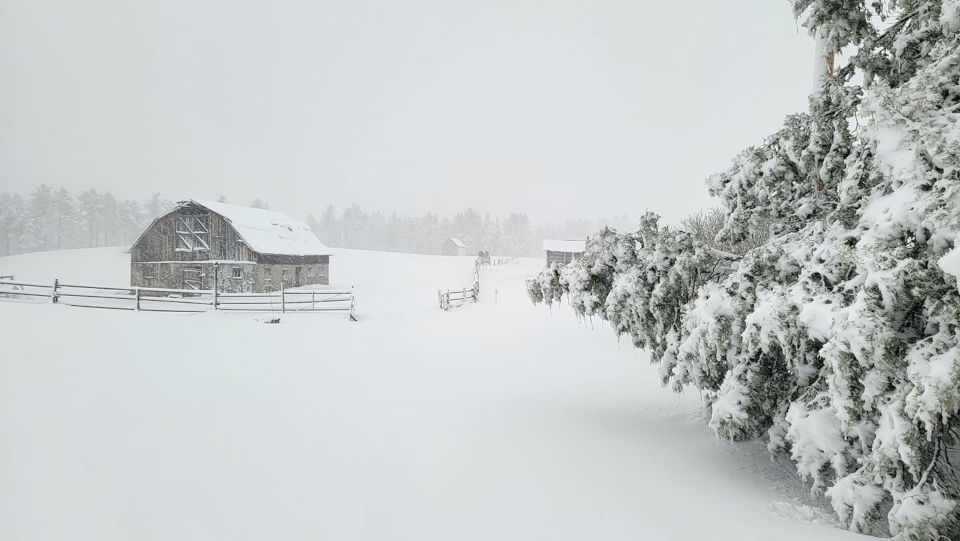
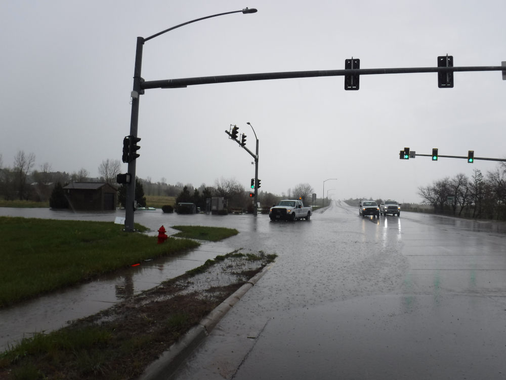
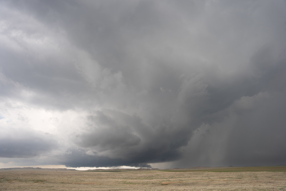
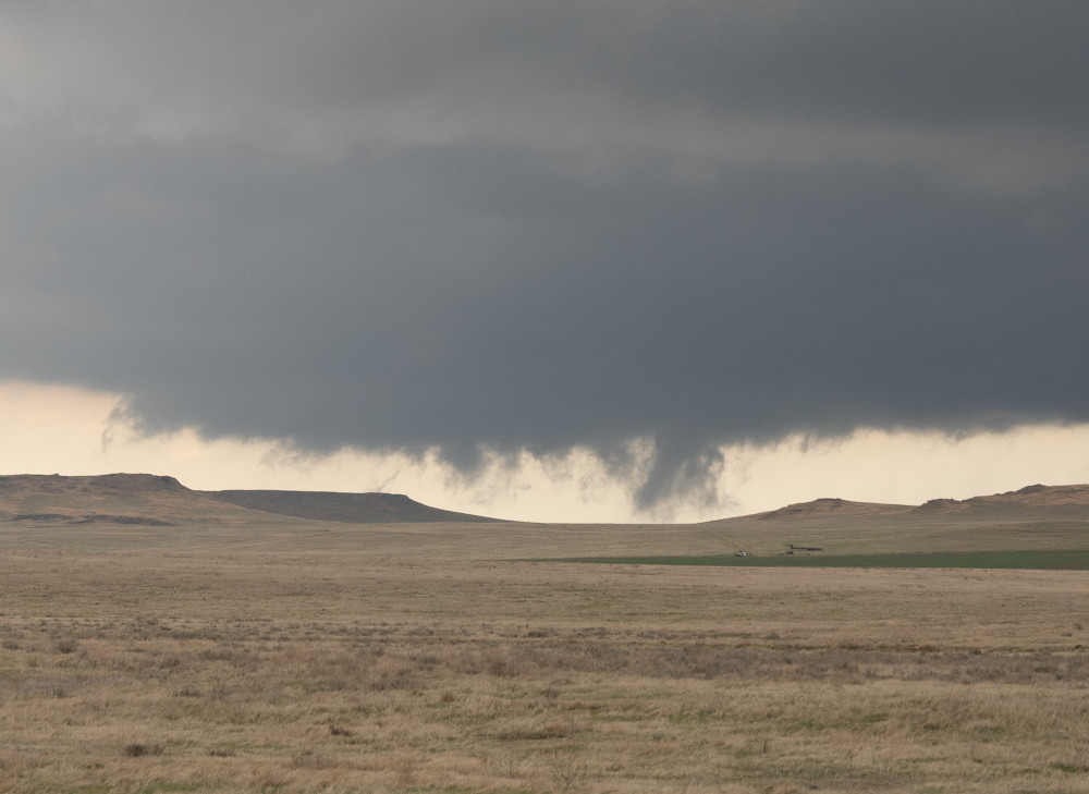
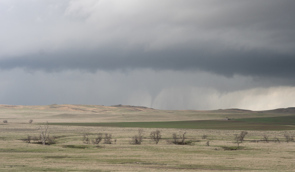
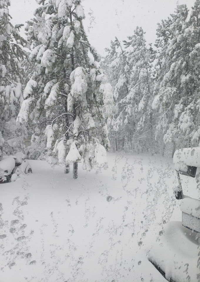
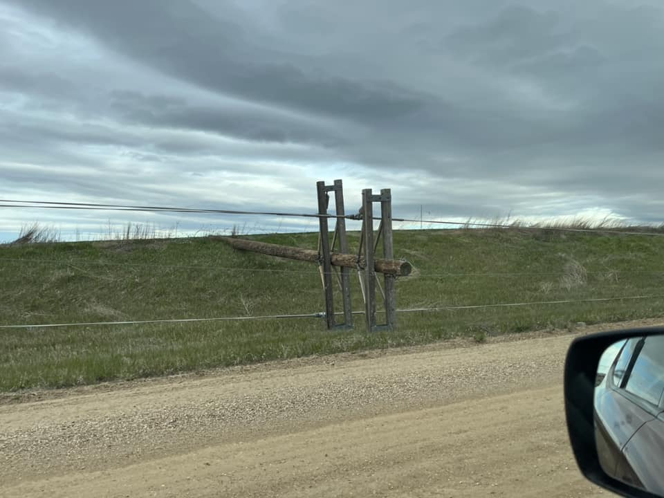
A strong upper-level low pressure moved from the Rockies on May 5, 2024, to the northern plains on May 6-8, 2024. Deep surface low pressure developed over southwestern North Dakota. Ahead of the system, strong gusty southeast winds developed on May 5 pulling in plentiful moisture. As the system strengthened May 6-7, strong northwest winds (up to 79 MPH) developed with heavy, wet snow over the highest Black Hills. Numerous power outages were reported coincident with the snow and high winds. As the two air masses clashed, a line of thunderstorms developed on May 6 in the morning. The thunderstorms produced minor flooding in Gillette, WY. Over western South Dakota, a line of thunderstorms developed – containing isolated severe thunderstorms – with one storm producing two tornadoes near Mud Butte, SD early in the afternoon on May 6. Significant liquid-equivalent precipitation fell. 1 to locally 3” fell over northeastern Wyoming and the Black Hills. Amounts on the western South Dakota plains varied widely with some folks getting very little and others around an inch. 14-18” of snow fell near Four Corners, WY, and O’Neil Pass, SD. |
 Moskee, WY Courtesy Becky Stoddard |
 Gillette, WY Courtesy David King |
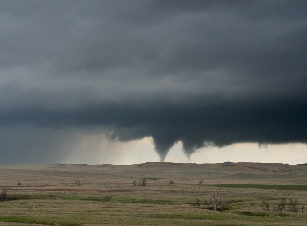 Near Mud Butte, SD May 6, 2024 1245 PM MDT Courtesy Joshua Tatman |
Tornadoes
|
Tornado #1 - 11 miles SW Mud Butte
Track Map 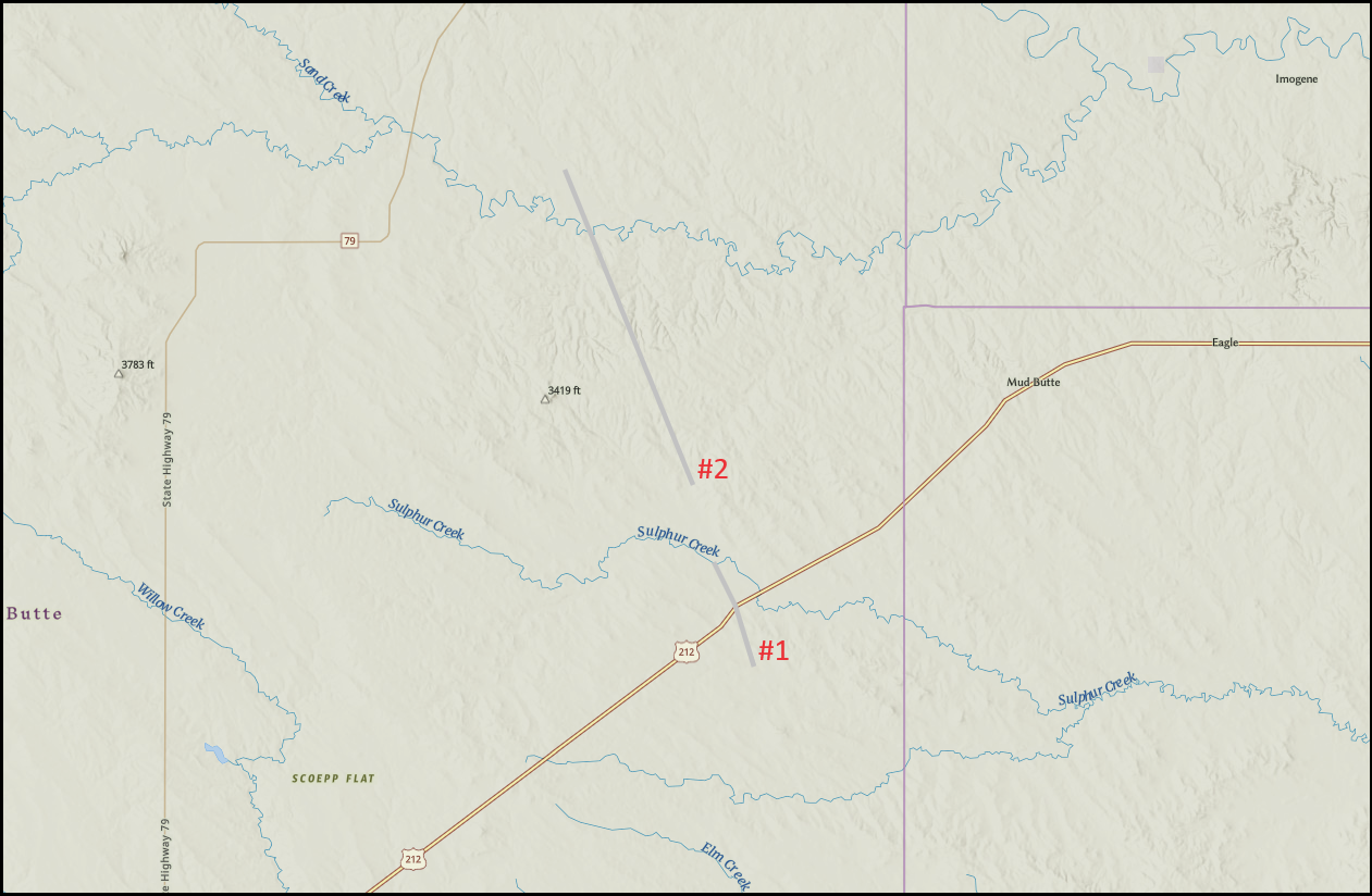 
Downloadable KMZ File |
||||||||||||||||
|
Tornado #2 - 12 miles W Mud Butte
Track Map
Downloadable KMZ File |
||||||||||||||||
The Enhanced Fujita (EF) Scale classifies tornadoes into the following categories:
| EF0 Weak 65-85 mph |
EF1 Moderate 86-110 mph |
EF2 Significant 111-135 mph |
EF3 Severe 136-165 mph |
EF4 Extreme 166-200 mph |
EF5 Catastrophic 200+ mph |
 |
|||||
Wind
 |
|||
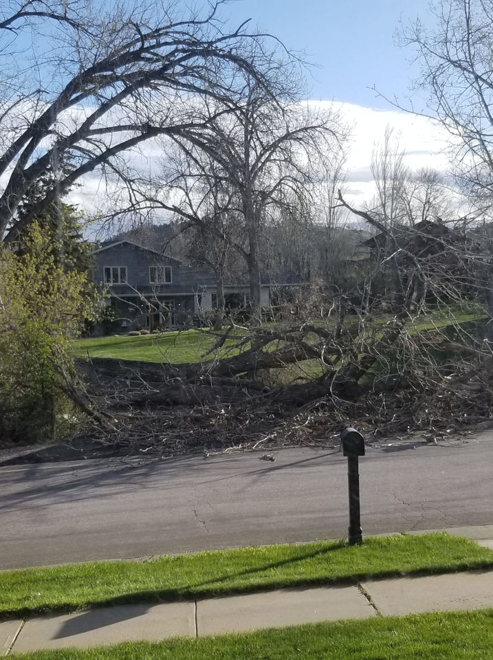
| Rapid City tree damage due to non-thunderstorm wind gusts Courtesy Katherine Anderson |
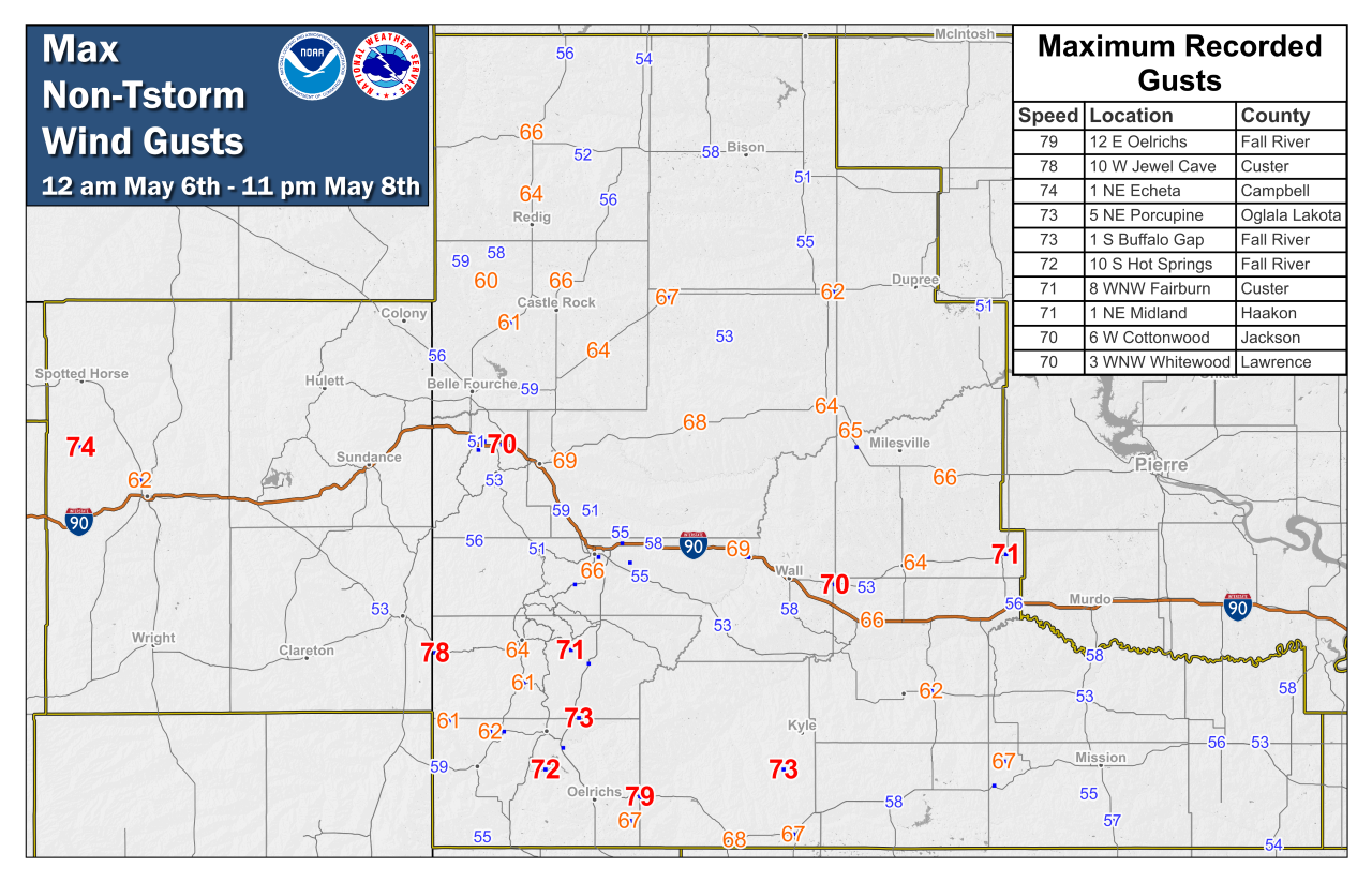
Map of peak non-thunderstorm wind gusts for May 6, 2024 12am to May 8, 2024 11pm.
Here is a listing of all peak wind gusts for May 5-7, 2024. Most of the maximum observed wind gusts were non-thunderstorm winds.
...MAXIMUM OBSERVED WINDS SORTED BY MAGNITUDE...

LOCATION                      MAX WIND    COMMENTS
                               MPH

12 E Oelrichs SD                 79       1023 PM 5/06/2024
10 W Jewel Cave SD               78       1245 AM 5/07/2024
1 NE Echeta WY                   74        751 PM 5/06/2024
1 S Buffalo Gap SD               73        835 PM 5/06/2024
5 NE Porcupine SD                73        341 AM 5/07/2024
10 S Hot Springs SD              72        916 PM 5/06/2024
1 NE Midland SD                  71        923 AM 5/07/2024
8 WNW Fairburn SD                71        318 AM 5/07/2024
3 WNW Whitewood SD               70        932 AM 5/07/2024
6 W Cottonwood SD                70        740 AM 5/07/2024
7 E Sturgis SD                   69        950 AM 5/07/2024
3 NW Wasta SD                    69        945 AM 5/07/2024
3 ESE Pine Ridge SD              68        205 AM 5/07/2024
15 SSE Mission SD                68        218 PM 5/06/2024
3 W Union Center SD              68        301 AM 5/07/2024
9 SW Batesland SD                67        119 AM 5/07/2024
1 ENE Mud Butte SD               67        509 PM 5/07/2024
6 W Parmelee SD                  67        428 PM 5/06/2024
11 ESE Oelrichs SD               67        130 AM 5/07/2024
4 S Dwtn Rapid City SD           66        310 AM 5/07/2024
4 E Cactus Flat SD               66        729 AM 5/07/2024
10 NNW Ottumwa SD                66        935 AM 5/07/2024
7 WSW Hoover SD                  66        514 AM 5/07/2024
1 N Buffalo SD                   66        747 AM 5/07/2024
11 W Hot Springs SD              65        313 AM 5/07/2024
2 ENE Rockerville SD             65        846 PM 5/06/2024
2 SW Bridger SD                  65        432 PM 5/07/2024
19 NNE Creighton SD              65        120 PM 5/06/2024
13 NE Newell SD                  64       1201 PM 5/07/2024
2 SSW Custer SD                  64        211 AM 5/07/2024
Howes SD                         64        858 AM 5/07/2024
8 N Redig SD                     64       1005 AM 5/07/2024
3 E Philip SD                    64        845 AM 5/07/2024
Union Center SD                  63        325 AM 5/07/2024
9 NNE Edgemont SD                62       1257 AM 5/07/2024
1 NNE Faith SD                   62        838 AM 5/07/2024
11 SW Parmelee SD                62       1028 PM 5/06/2024
7 E Wanblee SD                   62        404 PM 5/06/2024
5 NNW Dwtn Gillette WY           62        845 PM 5/06/2024
12 WSW Castle Rock SD            61        244 PM 5/07/2024
Pringle SD                       61        909 AM 5/07/2024
14 NNW Edgemont SD               61       1215 AM 5/07/2024
19 WNW Castle Rock SD            60        200 AM 5/07/2024
3 WSW Fairburn SD                60        953 PM 5/06/2024
3 SE Dwtn Spearfish SD           60        411 PM 5/07/2024
1 NNW Piedmont SD                59        330 AM 5/07/2024
4 NNE Angostura Res SD           59       1255 AM 5/07/2024
10 W Edgemont SD                 59       1235 AM 5/07/2024
11 W Milesville SD               59        320 PM 5/07/2024
1 NNW Nisland SD                 59       1155 PM 5/06/2024
27 WNW Castle Rock SD            59       1156 PM 5/06/2024
20 NW Castle Rock SD             58        530 PM 5/07/2024
8 E Prairie City SD              58       1030 AM 5/07/2024
5 WNW New Underwood SD           58        845 AM 5/07/2024
10 NNE White River SD            58        158 PM 5/06/2024
1 ESE Martin SD                  58        955 PM 5/06/2024
8 S Wall SD                      58        320 AM 5/07/2024
2 W Hamill SD                    58        125 PM 5/06/2024
4 N Ludlow SD                    57        257 PM 5/05/2024
13 W Oglala SD                   57        127 AM 5/07/2024
13 SSW Reva SD                   56       1153 AM 5/07/2024
7 NNE Ralph SD                   56        156 PM 5/05/2024
9 ENE Belvidere SD               56        143 PM 5/06/2024
13 NW Belle Fourche SD           56        849 PM 5/06/2024
4 SSE Witten SD                  56        223 PM 5/06/2024
6 W Rochford SD                  56        908 AM 5/07/2024
4 E Dwtn Spearfish SD            56       1115 AM 5/07/2024
Rapid City Arpt SD               56        359 PM 5/07/2024
1 WNW Caputa SD                  55        915 AM 5/07/2024
Usta SD                          55        915 AM 5/07/2024
Ellsworth AFB SD                 55        812 AM 5/07/2024
7 ESE Rosebud SD                 55       1200 AM 5/07/2024
7 W Ardmore SD                   55       1240 AM 5/07/2024
1 E Dwtn Rapid City SD           54        959 AM 5/07/2024
Bison SD                         54        415 PM 5/05/2024
1 W Box Elder SD                 54        852 AM 5/07/2024
Wewela SD                        54        328 PM 5/06/2024
3 ESE Lemmon SD                  53        355 PM 5/05/2024
1 NE Winner SD                   53        113 PM 5/06/2024
6 WSW Opal SD                    53        545 PM 5/07/2024
2 E Cottonwood SD                53        355 AM 5/07/2024
3 NNW Scenic SD                  53        208 PM 5/07/2024
1 S White River SD               53        155 PM 5/06/2024
6 WNW Newcastle WY               53       1255 AM 5/07/2024
1 E Lead SD                      53        900 AM 5/07/2024
3 W Lemmon SD                    53        113 PM 5/05/2024
1 ESE Ladner SD                  53        100 PM 5/05/2024
10 W Reva SD                     52        715 AM 5/07/2024
Wasta SD                         52        255 AM 5/07/2024
6 NE Summerset SD                51        627 AM 5/07/2024
2 ESE Dwtn Spearfish SD          51       1134 AM 5/07/2024
2 NNW Pactola Res SD             51        251 PM 5/07/2024
7 SSE Meadow SD                  51        425 PM 5/07/2024
3 N Redig SD                     51       1145 AM 5/05/2024
1 WSW South Eagle Butte SD       51        255 PM 5/06/2024
8 W Jewel Cave SD                50        854 AM 5/07/2024
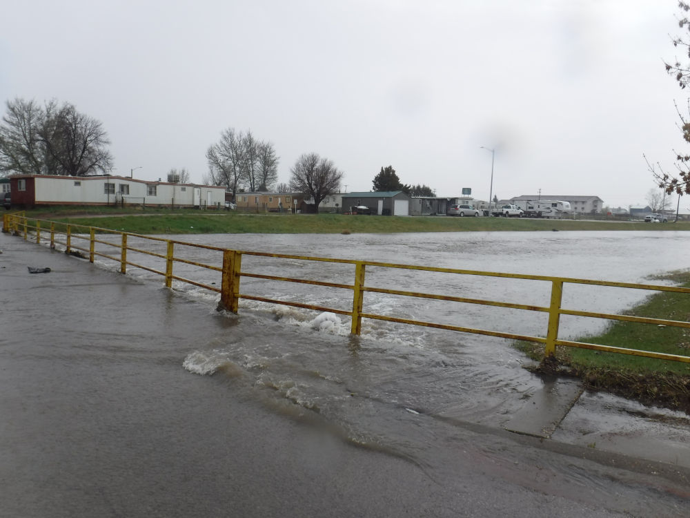
Flooding
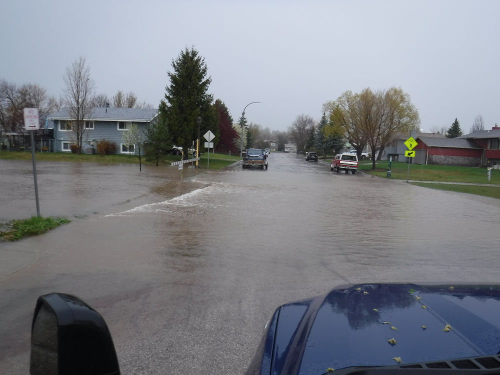
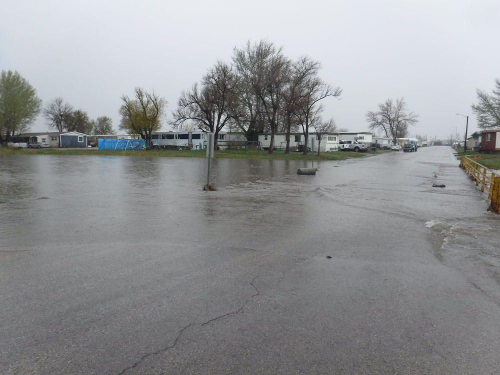
Locally heavy rain fell early in the morning on May 6, 2024 resulting in minor flooding in Gillette, WY.
 |
|
 |
 |
| Gillette, WY Courtesy David King |
Gillette, WY Courtesy David King |
Gillette, WY Courtesy David King |
Gillette, WY Courtesy David King |
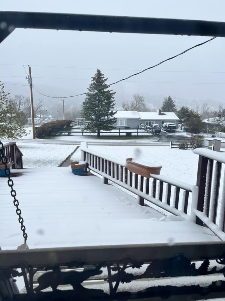
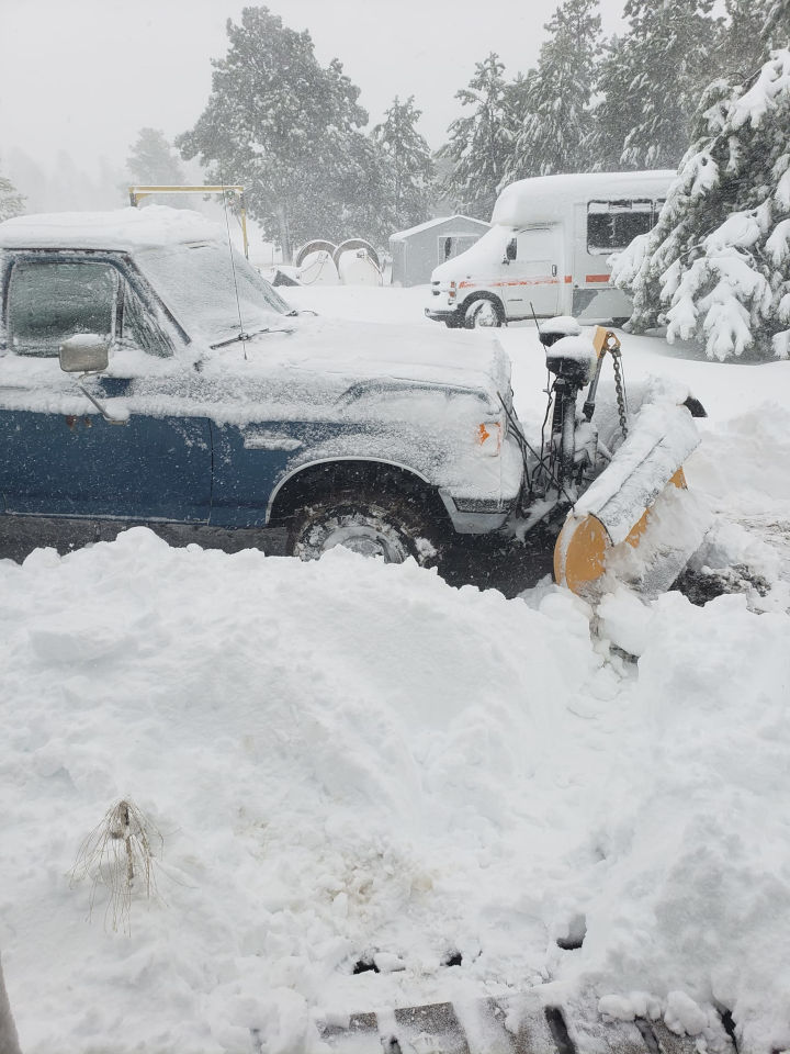
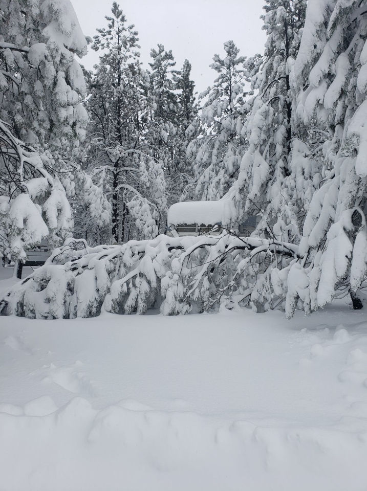
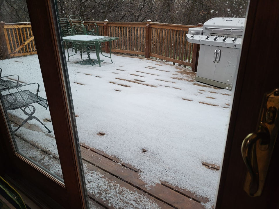
Snow
...PRELIMINARY SNOW AND SLEET TOTALS SORTED BY MAGNITUDE...

LOCATION                      SNOWFALL    COMMENTS
                               IN/S/

1 W O`Neil Pass SD             18.0       1000 AM 5/08/2024
4 NNE Four Corners WY          15.0       1200 PM 5/07/2024
5 W Sundance WY                 9.0       1011 PM 5/07/2024
8 NNW Newcastle WY              9.0        700 AM 5/07/2024
3 SE Deerfield SD               7.0       1044 AM 5/07/2024
7 SSE Sundance WY               6.0        759 AM 5/07/2024
Rochford SD                     6.0       1100 AM 5/07/2024
3 ESE Cheyenne Crossing SD      5.4        700 AM 5/08/2024
Cheyenne Crossing SD            3.0        756 AM 5/07/2024
Sundance WY                     2.3        600 AM 5/08/2024
1 ESE Newcastle WY              2.0        900 AM 5/07/2024
1 SE Newcastle WY               2.0        800 AM 5/07/2024
Mount Rushmore SD               0.2       1258 AM 5/08/2024
Photos & Video
Tornadoes (May 6, 2024)
 |
 |
|
 |
| Near Mud Butte, SD Before Tornadogenesis Courtesy Joshua Tatman |
Near Mud Butte, SD 1229 PM MDT Courtesy Joshua Tatman |
Near Mud Butte, SD 1245 PM MDT Courtesy Joshua Tatman |
Near Mud Butte, SD 1248 PM MDT Courtesy Joshua Tatman |
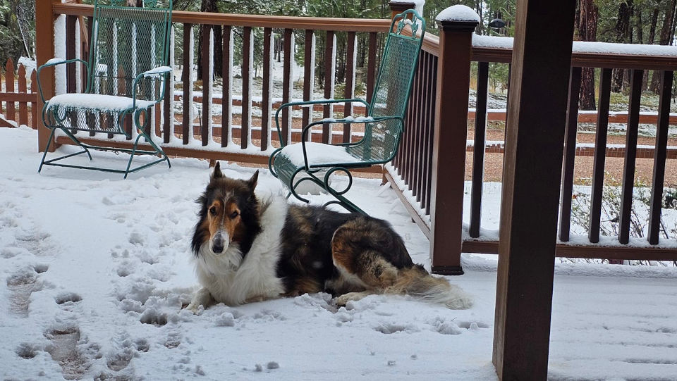
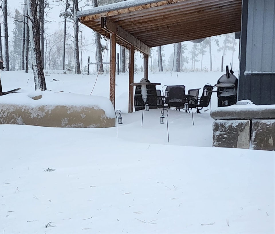
Snow
 |
 |
 |
 |
| Sundance, WY Courtesy Dave Hurd |
Custer, SD Courtesy Karen Henman |
O'Neill Pass, SD Courtesy Karri Riege |
Four Corners, WY Courtesy Missy Brand |
 |
 |
 |
|
| Four Corners, WY Courtesy Missy Brand |
Four Corners, WY Courtesy Missy Brand |
12S Deadwood, SD Courtesy Tammy Burns |
Moskee, WY Courtesy Becky Stoddard |
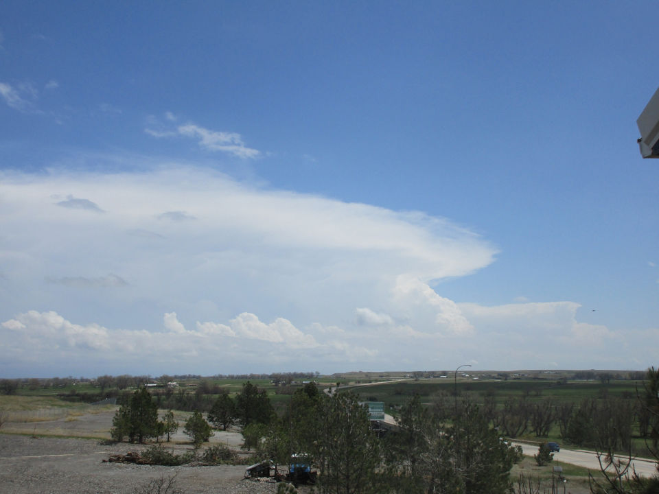
Thunderstorms
 |
 |
 |
|
| Downed Power Pole 3WNW Batesland, SD Courtesy AJ Granelli |
May 6, 2024 Noon: Taken in Belle Fource looking east toward the storm that produced the tornado Courtesy Cobra H Rhod |
Pea Size Hail in Whitewood, SD Courtesy Sharon Kirkpatrick-Sanchez |
Twin tornados yesterday southwest of Mud Butte, South Dakota. Surprisingly stout given the marginal parameters.
— Slim Tatman (@SlimTatman) May 7, 2024
Several other storms in the vicinity also had brief rotations and funnels, but didn't have adequately perpendicular shear. pic.twitter.com/JpKulIaDHq
Tornado Southwest of mud Butte, South Dakota about 12:45 p.m. @BrantBeckmanwx @NWSRapidCity pic.twitter.com/FLMrDoqc6a
— Slim Tatman (@SlimTatman) May 6, 2024
Fast scud rises and several possible funnels on base of storm approaching mud Butte. 12:30 p.m. @BrantBeckmanwx @NWSRapidCity pic.twitter.com/AEuQw82MSP
— Slim Tatman (@SlimTatman) May 6, 2024
Things got interesting for a quick second north east of Faith #sdwx around 3:50 local time â¦@NWSRapidCityâ© pic.twitter.com/myRGXLkxtx
— Shane Ornelas (@ShaneHpns) May 6, 2024
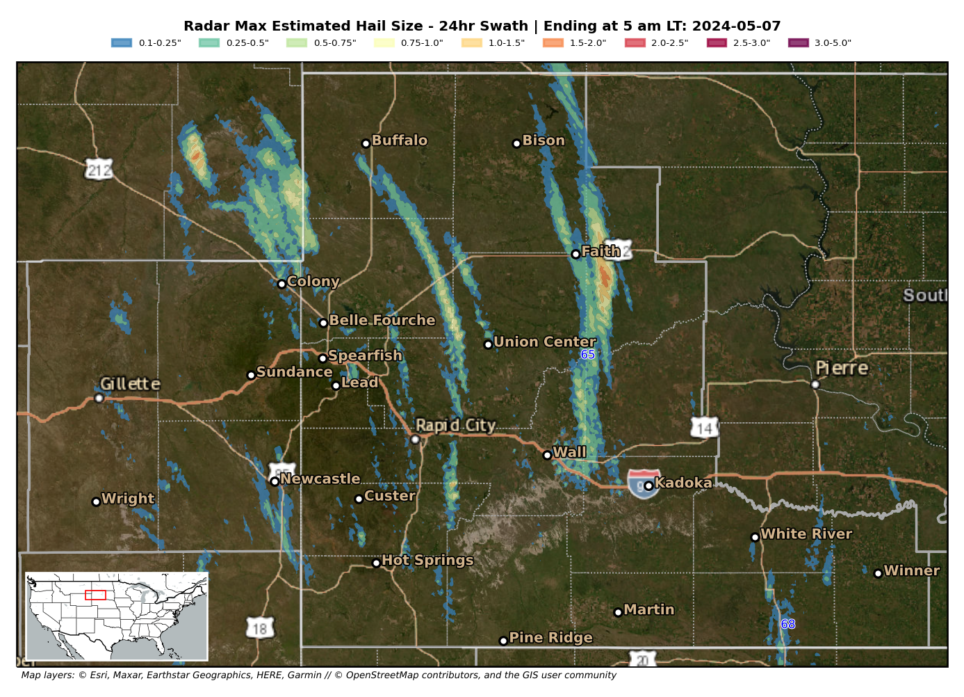
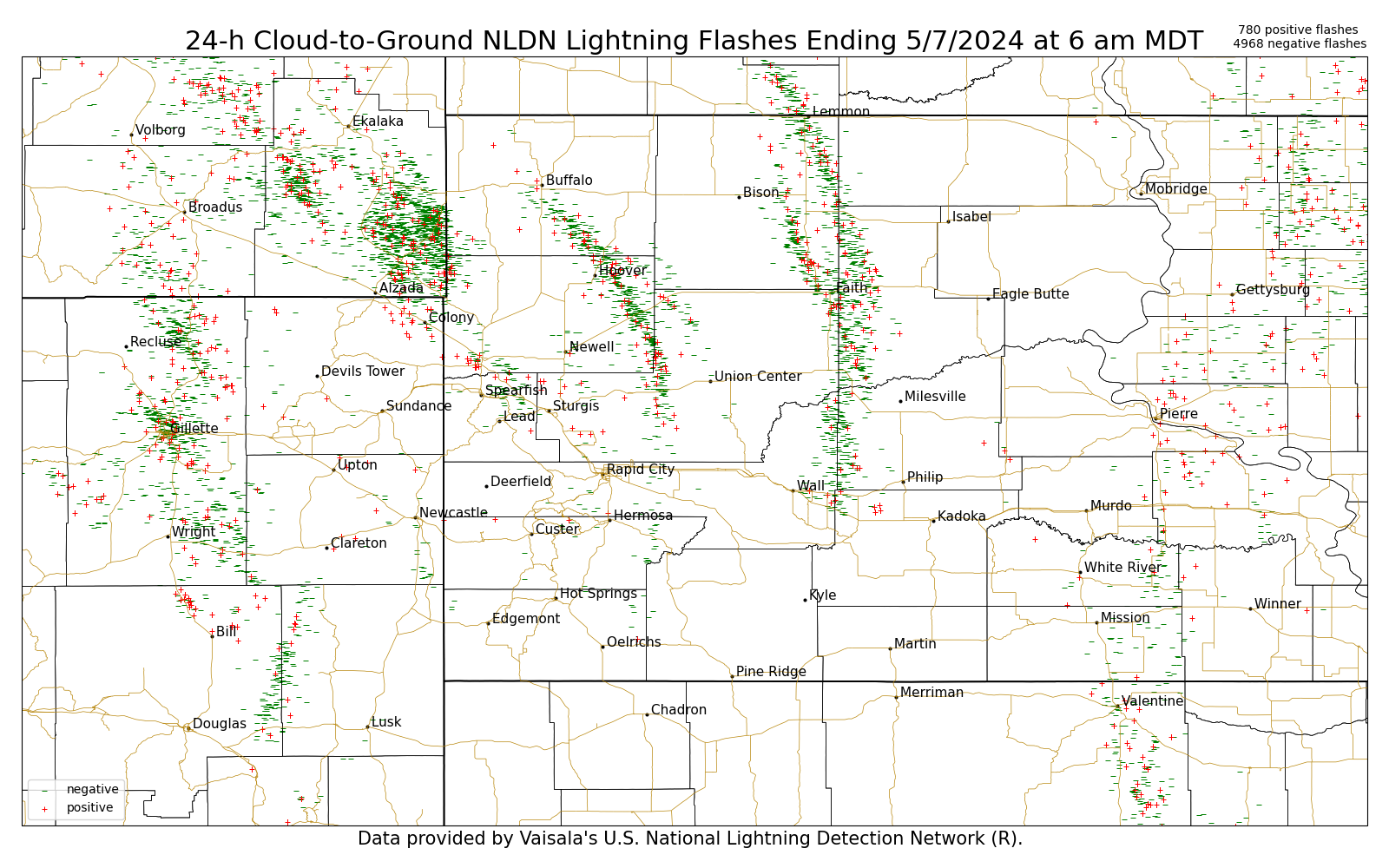
Radar
 |
 |
 |
 |
| Radar Estimated Hail Tracks May 6, 2024 |
24-hour Cloud-to-Ground Lightning Flashes May 6, 2024 |
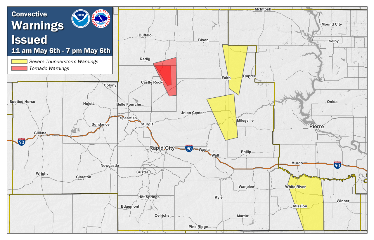
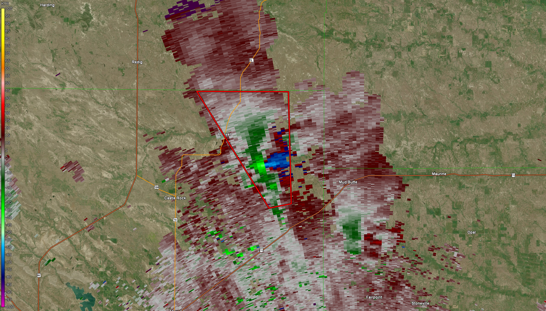
May 6, 2024 11am to 7pm Convective Warning Polygons | Radar Storm Relative Velocity During the 2nd Tornado May 6, 2024 120pm |
May 6, 2024 6am to 12pm Radar Loop
May 6, 2024 12pm to 6pm Radar Loop
May 6, 2024 6pm to May 7, 2024 6pm Radar Loop
Rain Reports
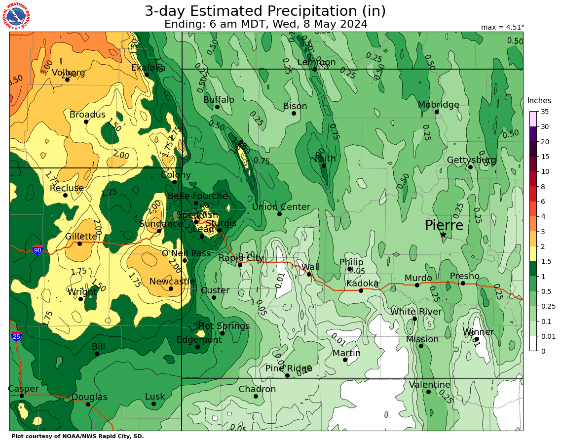
Estimated 3-day precipitation May 5, 2024 6am MDT to May 8, 2024 6am
...PRELIMINARY RAINFALL TOTALS SORTED BY MAGNITUDE...

LOCATION                      TOTAL RAIN  COMMENTS
                               IN/S/

1 S Devils Tower WY            3.18        800 AM 5/08/2024
8 NNW Newcastle WY             3.10        700 AM 5/08/2024
3 SE Saint Onge SD             3.09        600 AM 5/08/2024
5 SSE Dwtn Gillette WY         3.06        624 AM 5/08/2024
Sundance WY                    3.03        600 AM 5/08/2024
4 SSW Saint Onge SD            2.96        700 AM 5/08/2024
1 SSW Rozet WY                 2.90        800 AM 5/08/2024
1 SE Newcastle WY              2.68        800 AM 5/08/2024
1 N Upton WY                   2.68        800 AM 5/08/2024
1 ESE Newcastle WY             2.65        900 AM 5/07/2024
11 NNE Weston WY               2.47        700 AM 5/08/2024
1 WSW Newcastle WY             2.46        700 AM 5/08/2024
1 SSW Sturgis SD               2.37        700 AM 5/08/2024
10 N Osage WY                  2.32        700 AM 5/08/2024
5 NNW Dwtn Gillette SD         2.28        800 AM 5/08/2024
19 SW Upton WY                 2.22        800 AM 5/08/2024
14 SW Weston WY                2.17        800 AM 5/07/2024
3 E Newcastle WY               2.17        600 AM 5/08/2024
8 ENE Alva WY                  2.15        700 AM 5/08/2024
Newcastle WY                   2.15        445 AM 5/07/2024
9 NNE Edgemont SD              2.10        800 AM 5/08/2024
3 SE Nisland SD                1.95        800 AM 5/08/2024
25 ESE Wright SD               1.92        800 AM 5/07/2024
3 SE Spearfish SD              1.88        800 AM 5/08/2024
Vale SD                        1.86        730 AM 5/07/2024
Wright WY                      1.73        700 AM 5/08/2024
4 SSE Devils Tower WY          1.73        730 AM 5/08/2024
1 S Belle Fourche SD           1.66        700 AM 5/08/2024
2 W Moorcroft WY               1.63        700 AM 5/08/2024
8 WSW Rozet WY                 1.62        700 AM 5/08/2024
3 NNE Moorcroft WY             1.59        600 AM 5/08/2024
1 SSE Dwtn Spearfish SD        1.58        800 AM 5/08/2024
7 SE Moorcroft WY              1.57        800 AM 5/08/2024
4 SE Upton WY                  1.50        700 AM 5/08/2024
14 NW Edgemont SD              1.42        800 AM 5/07/2024
Lemmon SD                      1.41        600 PM 5/06/2024
1 SW Newell SD                 1.37        800 AM 5/08/2024
1 NNW Dwtn Spearfish SD        1.37       1000 AM 5/08/2024
1 NE Echeta WY                 1.36        800 AM 5/08/2024
1 NW Dwtn Spearfish SD         1.36        800 AM 5/08/2024
9 NNE Sturgis SD               1.27        700 AM 5/08/2024
3 SSW Argyle SD                1.27        700 AM 5/08/2024
Parmlee SD                     1.27        800 AM 5/07/2024
2 WNW Dwtn Spearfish SD        1.26        700 AM 5/08/2024
Edgemont SD                    1.25        700 AM 5/08/2024
5 SW Upton WY                  1.25        700 AM 5/08/2024
Tilford SD                     1.24        700 AM 5/07/2024
Lead SD                        1.23        900 AM 5/08/2024
6 NNW Dwtn Spearfish SD        1.21        700 AM 5/08/2024
11 NE Morrisey WY              1.20        700 AM 5/07/2024
14 NNW Dwtn Gillette WY        1.20        700 AM 5/07/2024
1 NNE Faith SD                 1.19        800 AM 5/07/2024
4 NNW Tilford SD               1.15        800 AM 5/07/2024
1 ESE Moorcroft WY             1.12        600 AM 5/08/2024
1 NNE Edgemont SD              1.10        700 AM 5/07/2024
2 ENE Edgemont SD              1.08        700 AM 5/07/2024
2 E Vale SD                    1.06        800 AM 5/08/2024
Newell SD                      1.05        900 AM 5/07/2024
1 WNW Lemmon SD                1.03        900 AM 5/06/2024
1 NNW Nisland SD               1.03        800 AM 5/08/2024
2 NW Sundance WY               1.01        700 AM 5/08/2024
3 ESE Cheyenne Crossing SD     1.00        700 AM 5/08/2024
1 E Lead SD                    0.95        800 AM 5/08/2024
1 WSW Custer SD                0.90        800 AM 5/07/2024
1 NNW Piedmont SD              0.88        800 AM 5/07/2024
14 NNW Edgemont SD             0.88        800 AM 5/08/2024
1 SW Deadwood SD               0.85       1243 AM 5/07/2024
6 SE Dwtn Gillette WY          0.83        800 AM 5/07/2024
4 W Custer SD                  0.81        800 AM 5/08/2024
13 W Rockypoint WY             0.80        800 PM 5/05/2024
6 WSW Provo SD                 0.78        800 AM 5/07/2024
5 SW Brownsville SD            0.77        800 AM 5/08/2024
4 W Hot Springs SD             0.75        700 AM 5/07/2024
6 SW Beulah WY                 0.75        800 AM 5/07/2024
4 SE Sturgis SD                0.74        800 AM 5/08/2024
2 E Sturgis SD                 0.72        700 PM 5/07/2024
3 SSE Harding SD               0.70        900 AM 5/07/2024
27 WNW Castle Rock SD          0.70        800 AM 5/08/2024
7 E Sturgis SD                 0.68        800 AM 5/08/2024
Piedmont SD                    0.67        700 AM 5/07/2024
Hot Springs SD                 0.64        700 AM 5/08/2024
1 WNW Wind Cave Visitors Cent  0.54        200 PM 5/07/2024
4 NW Dwtn Rapid City SD        0.54        700 AM 5/07/2024
14 SSW Provo SD                0.54        800 AM 5/07/2024
1 W Wind Cave Visitors Center  0.52        800 AM 5/08/2024
19 NNE Creighton SD            0.52        700 AM 5/07/2024
7 W Ardmore SD                 0.47        800 AM 5/08/2024
2 S Pactola Resv SD            0.45        600 AM 5/07/2024
4 SE Gillette WY               0.45        530 PM 5/07/2024
Nemo SD                        0.42        800 AM 5/08/2024
7 S Shadehill SD               0.41        800 AM 5/08/2024
4 W Dwtn Rapid City SD         0.39        700 AM 5/08/2024
10 E Custer SD                 0.39        730 AM 5/07/2024
2 SSW Custer SD                0.38        800 AM 5/07/2024
9 SSE Sorum SD                 0.37        700 AM 5/08/2024
4 WNW Dwtn Rapid City SD       0.34        700 AM 5/07/2024
Jewel Cave SD                  0.34        800 AM 5/08/2024
6 WSW Opal SD                  0.32        700 AM 5/08/2024
2 WSW Hamill SD                0.31        700 AM 5/07/2024
3 ESE Lemmon SD                0.28        800 AM 5/08/2024
2 N Summerset SD               0.27        800 AM 5/07/2024
6 WNW Union Center SD          0.26        700 AM 5/08/2024
9 N Cedar Butte SD             0.26        600 AM 5/08/2024
4 NNE Johnson Siding SD        0.26        800 AM 5/07/2024
4 NNE Summerset SD             0.25        600 AM 5/07/2024
9 NW Ludlow SD                 0.25        700 AM 5/07/2024
14 WNW Lodgepole SD            0.25        800 AM 5/08/2024
7 WSW Folsom SD                0.24        530 AM 5/07/2024
12 NNW White River SD          0.22        700 AM 5/08/2024
Mount Rushmore SD              0.22       1258 AM 5/08/2024
3 NE Hisega SD                 0.21        700 AM 5/07/2024
3 NNE Johnson Siding SD        0.21        700 AM 5/07/2024
2 WNW Custer SD                0.21        800 AM 5/08/2024
7 WSW Fairburn SD              0.20        830 AM 5/07/2024
Union Center SD                0.20        800 AM 5/08/2024
16 SSE Mission SD              0.20        600 AM 5/07/2024
10 W Reva SD                   0.19        800 AM 5/08/2024
Hill City SD                   0.19        700 AM 5/07/2024
9 SE Meadow SD                 0.19        700 AM 5/07/2024
4 W Rapid City SD              0.19        800 AM 5/07/2024
1 N Buffalo SD                 0.19        800 AM 5/08/2024
6 NE Summerset SD              0.18        800 AM 5/07/2024
5 ENE Custer SD                0.18        700 AM 5/07/2024
1 WSW South Eagle Butte SD     0.16        800 AM 5/08/2024
4 WNW Cedar Butte SD           0.15        800 AM 5/08/2024
12 SSE Milesville SD           0.15        700 AM 5/06/2024
4 E Hisega SD                  0.14        652 AM 5/07/2024
14 S Mission SD                0.13        700 AM 5/07/2024
1 ESE Pactola Resv SD          0.13        900 AM 5/07/2024
9 N Kirley SD                  0.12        900 AM 5/06/2024
1 N Hisega SD                  0.12        700 AM 5/07/2024
2 WNW Dwtn Rapid City SD       0.12        700 AM 5/07/2024
3 ESE Pine Ridge SD            0.11        800 AM 5/08/2024
3 WNW Kadoka SD                0.11        530 AM 5/07/2024
1 ENE Custer SD                0.11        700 AM 5/07/2024
2 E Cottonwood SD              0.11        200 PM 5/07/2024
7 N Wood SD                    0.10        600 AM 5/08/2024
6 W New Underwood SD           0.10        700 AM 5/07/2024
2 E Cottonwood SD              0.10        800 AM 5/07/2024
3 N Ottumwa SD                 0.10        700 AM 5/08/2024
6 SSW Fairpoint SD             0.10        635 AM 5/08/2024
4 NNW Elm Springs SD           0.09        600 AM 5/08/2024
6 W Hermosa SD                 0.09        700 AM 5/07/2024
1 WNW Caputa SD                0.09        800 AM 5/07/2024
5 NW Swett SD                  0.09        756 AM 5/07/2024
2 SW Dwtn Rapid City SD        0.08        800 AM 5/07/2024
8 WNW Fairburn SD              0.08        800 AM 5/07/2024
Bison SD                       0.08        800 AM 5/08/2024
6 W Rochford SD                0.08        800 AM 5/08/2024
7 N Kirley SD                  0.08        700 AM 5/06/2024
7 ESE Rosebud SD               0.08        800 AM 5/07/2024
Oral SD                        0.07        700 AM 5/06/2024
9 N Wewela SD                  0.07        700 AM 5/07/2024
11 W Milesville SD             0.07        800 AM 5/07/2024
1 S White River SD             0.07        800 AM 5/07/2024
2 ENE Sheridan Lake SD         0.06        800 AM 5/07/2024
Rapid City Arpt SD             0.06        800 AM 5/07/2024
4 S Dwtn Rapid City SD         0.05        700 AM 5/07/2024
3 WNW Milesville SD            0.05        700 AM 5/06/2024
Hermosa SD                     0.05        600 AM 5/07/2024
7 NNE Ellsworth AFB SD         0.05        700 AM 5/07/2024
9 ENE Wewela SD                0.04        600 AM 5/07/2024
3 E Philip SD                  0.04        800 AM 5/07/2024
11 SSE Hamill SD               0.03        600 AM 5/07/2024
12 S Quinn SD                  0.03        800 AM 5/07/2024
1 SSW Box Elder SD             0.03        700 AM 5/07/2024
5 NE Porcupine SD              0.03        800 AM 5/07/2024
Cedar Pass SD                  0.03        500 PM 5/07/2024
5 NE Milesville SD             0.02        700 PM 5/07/2024
Wasta SD                       0.02        800 AM 5/07/2024
1 SW Dwtn Rapid City SD        0.02        700 AM 5/08/2024
1 NE Dwtn Rapid City SD        0.02        600 AM 5/08/2024
2 SSW Oral SD                  0.01        800 AM 5/07/2024
1 NE Winner SD                 0.01        800 AM 5/07/2024
8 S Wall SD                    0.01        800 AM 5/07/2024
2 W Hamill SD                  0.01        800 AM 5/07/2024
4 NW Parmelee SD               0.01        700 AM 5/08/2024
 |
Media use of NWS Web News Stories is encouraged! Please acknowledge the NWS as the source of any news information accessed from this site. |
|

