HOME
FORECAST
Local
Graphical
Aviation
Marine
Rivers and Lakes
Hurricanes
Severe Weather
Fire Weather
Sun/Moon
Long Range Forecasts
Climate Prediction
Space Weather
PAST WEATHER
Past Weather
Heating/Cooling Days
Monthly Temperatures
Records
Astronomical Data
SAFETY
Tsunamis
Floods
Beach Hazards
Wildfire
Cold
Tornadoes
Air Quality
Fog
Heat
Hurricanes
Lightning
Safe Boating
Rip Currents
Thunderstorms
Space Weather
Sun (Ultraviolet Radiation)
Safety Campaigns
Wind
Drought
Winter Weather
INFORMATION
Wireless Emergency Alerts
Brochures
Weather-Ready Nation
Cooperative Observers
Daily Briefing
Damage/Fatality/Injury Statistics
Forecast Models
GIS Data Portal
NOAA Weather Radio
Publications
SKYWARN Storm Spotters
StormReady
TsunamiReady
Service Change Notices
EDUCATION
Be A Force of Nature
NWS Education Home
NEWS
NWS News
Events
Pubs/Brochures/Booklets
NWS Media Contacts
SEARCH
Search For
NWS
All NOAA
ABOUT
About NWS
Organization
Strategic Plan
Commitment to Diversity
For NWS Employees
International
National Centers
Careers
Contact Us
Glossary
Social Media
Local forecast by
"City, St" or ZIP code
Sorry, the location you searched for was not found. Please try another search.
Multiple locations were found. Please select one of the following:
Location Help
News Headlines
Storm Survey Results from May 8-9 Event: Four Tornadoes Confirmed
Customize Your
Weather.gov
Enter Your City, ST or ZIP Code
Remember Me
LOADING...
Greenville-Spartanburg, SC
Weather Forecast Office
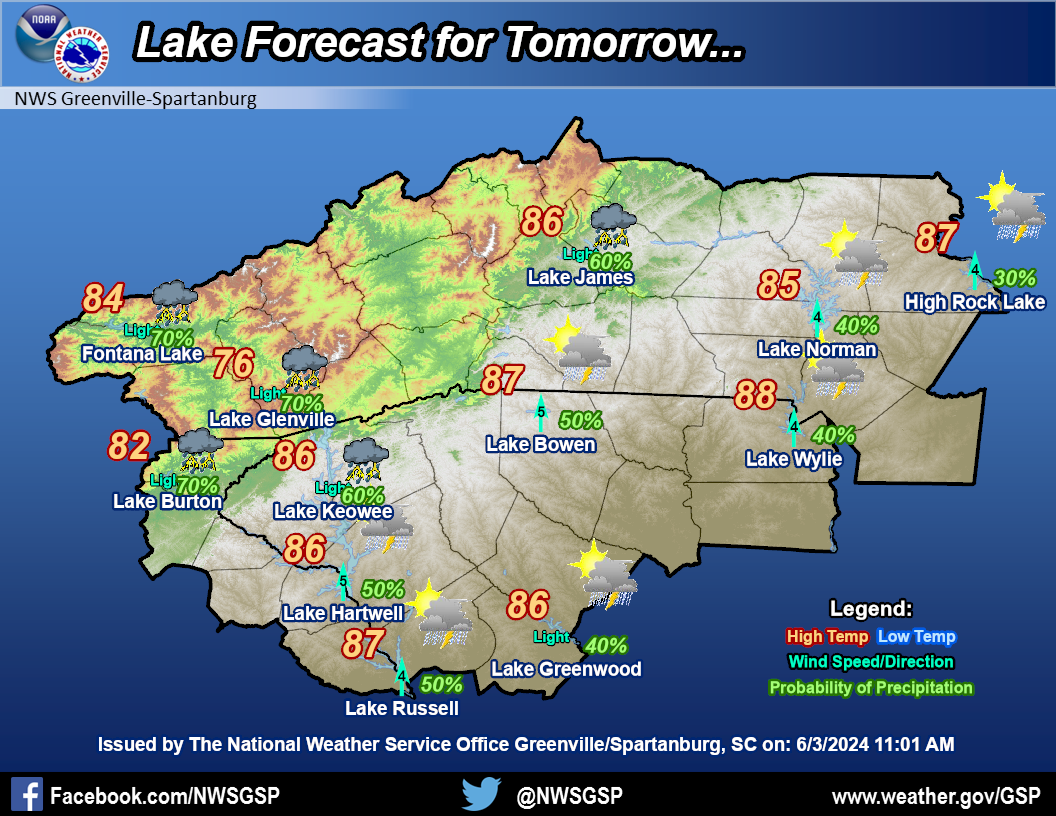
Lake Forecasts
Weather.gov
>
Greenville-Spartanburg, SC
> Lake Forecasts
Current Hazards
River Flooding
Briefing Page
Winter
Space
Local Outlook
Drought
Thunderstorms
Hurricanes
Reporting Severe Weather
Current Conditions
Observations (List)
Rainfall
Air Quality
Satellite
Observations (Map)
Radar
Local KGSP Standard Radar (low bandwidth)
Charlotte Radar
Regional Standard Radar (low bandwidth)
National Standard Radar (low bandwidth)
Local KGSP Enhanced Radar
Forecasts
Forecasters' Discussion
Hourly View
Map View
Aviation
Tropical
Activity Planner
Fire Weather
Marine
Recreational
Winter
Rivers and Lakes
*New* National Water Prediction Service (NWPS)
*New* NWPS - Local View
River Observations (Map)
River Forecasts (Map)
Current & Past Streamflow
Ensemble River Guidance
River Forecast Centers
Climate and Past Weather
Past Observed Weather
24 Hour Summary
CoCoRaHS
Past Rainfall
Snowfall Records
Drought Outlook
Historical Records
Climate Prediction
Daily Temp and Precip Maps
Historic Western Carolinas & Northeast Georgia Tornadoes
This Date in GSP Weather History
Local Programs
Local Research
Newsletter
Skywarn
NOAA Weather Radio
CoCoRaHS
Education and Outreach
Other Links
Cooperative Observers
WRN Ambassadors
Office Staff
×
Forecast Map
Radar
Click an icon on the map to display the forecast for the lake location or click a lake in the table below the map
Your browser does not support inline frames or is currently configured not to display  <p>
Lake Forecast Points
Lake Adger
Graphical Forecast
Lake Bowen
Graphical Forecast
Lake Burton
Graphical Forecast
Fontana Lake
Graphical Forecast
Lake Glenville
Graphical Forecast
Lake Greenwood
Graphical Forecast
Lake Hartwell
Graphical Forecast
High Rock Lake
Graphical Forecast
Lake James
Graphical Forecast
Lake Jocassee
Graphical Forecast
Lake Keowee
Graphical Forecast
Lake Lure
Graphical Forecast
Nantahala Lake
Graphical Forecast
Lake Norman
Graphical Forecast
Lake Russell
Graphical Forecast
Santeetlah Lake
Graphical Forecast
Lake Toxaway
Graphical Forecast
Lake Wylie
Graphical Forecast
Lake Forecast Images
Radar
Current Weather
Rivers & Lakes
Satellite
Forecast Maps
Hour by Hour Forecast
Tropical Weather
Graphical Hazards
Weather Hazard Briefing
Submit Storm Report
Fire Weather
Drought
Lake Forecasts
Recreational Forecast
Text Forecasts & Hazards
Forecaster's Discussion
NOAA Weather Radio
Current Conditions Map
Follow us on Twitter
Follow us on Facebook
Follow us on YouTube
GSP RSS Feed


 Current Conditions Map
 Follow us on YouTube