|
|

Our office broadcasts continuous weather information and short fused warnings on 9
transmitters serving Northeast Georgia, Upstate South Carolina and Western North Carolina
|
|
Call Sign |
Frequency |
Location |
|
WXJ-21 |
162.550 MHz |
Greenville, SC |
|
WXL-56 |
162.400 MHz |
Asheville, NC |
|
WXL-70 |
162.475 MHz |
Charlotte, NC |
|
WWH-24 |
162.425 MHz |
Toccoa, GA |
|
WWG-82 |
162.525 MHz |
Nantahala, NC |
|
KXI-81 |
162.450 MHz |
Rabun, GA |
|
WNG-538 |
162.450 MHz |
Linville, NC |
|
KHC-27 |
162.425 MHz |
Rock Hill, SC |
|
KJY-85 |
162.525 MHz |
Mooresville, NC |
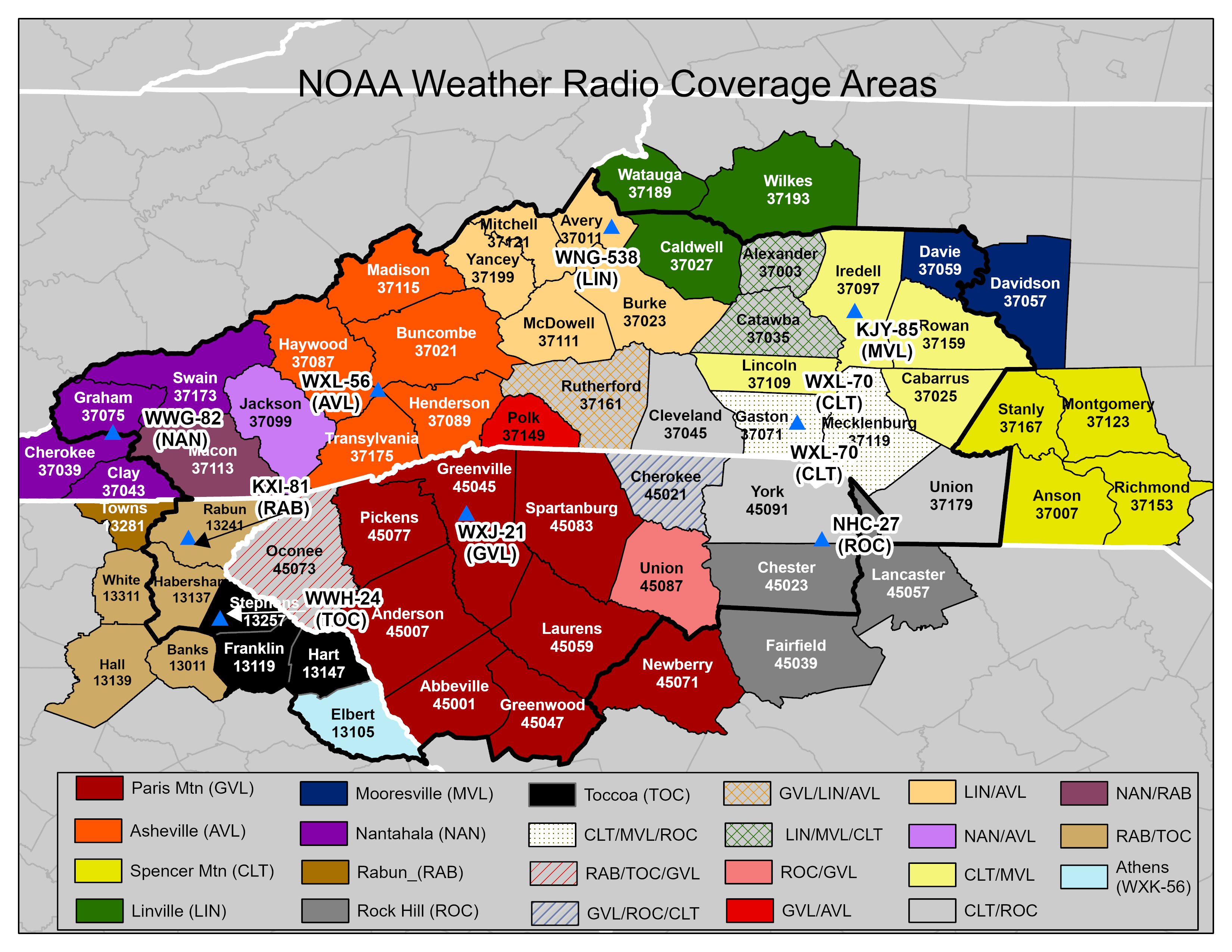
NOAA Weather Radio broadcasts can usually be heard within a 40
mile radius of the antenna site, sometimes more. The effective range depends on many factors,
particularly the height of the broadcasting antenna, terrain, quality of the receiver, and type of
receiving antenna. The map below shows transmitter locations in our County Warning Area (CWA), as
well as transmitters close to our CWA.
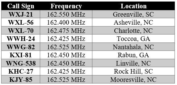
A list of third-party Web sites with Streaming Online Audio from NWR transmitters.
The red circles designate GSP transmitter sites, and yellow cirlces designate
transmitters in surrounding CWA's that SAME/tone alert for GSP counties. CLICK ON MAP TO ENLARGE.
The following is a list of the counties that each transmitter serves. Click on the links to
the right of the station name and ID to see a county map of the broadcast service area, or a map of
the transmitter coverage area.
-
Greenville (WXJ-21) - County Broadcast Service
Area, Coverage Map
-
North Carolina: Polk and Rutherford
-
South Carolina: Abbeville, Anderson, Cherokee, Greenville, Greenwood, Laurens, Newberry,
Oconee, Pickens, Spartanburg, and Union
-
Asheville (WXL-56) - County Broadcast Service
Area, Coverage Map
-
North Carolina: Avery, Buncombe, Burke, Haywood, Henderson, Jackson, Madison, McDowell,
Mitchell, Polk, Rutherford, Transylvania, and Yancey
-
Charlotte (WXL-70) - County Broadcast Service
Area, Coverage Map
-
North Carolina: Alexander, Anson, Cabarrus, Catawba, Cleveland, Gaston, Iredell, Lincoln,
Mecklenburg, Montgomery, Richmond, Rowan, Stanly and Union
-
South Carolina: Cherokee and York
-
Toccoa (WWH-24) - County Broadcast Service
Area, Coverage Map
-
Georgia: Banks, Franklin, Habersham, Hall, Hart, Rabun, Stephens, and White
-
Nantahala (WWG-82) - County Broadcast Service
Area, Coverage Map
-
North Carolina: Cherokee, Clay, Graham, Jackson, Macon, and Swain
-
Rabun (KXI-81) - County Broadcast Service
Area, Coverage Map
-
Georgia: Banks, Habersham, Hall, Rabun, Towns, and White
-
Linville (WNG-538) - County Broadcast Service
Area, Coverage Map
-
North Carolina: Alexander, Avery, Burke, Caldwell, Catawba, McDowell, Mitchell, Rutherford,
Watauga, Wilkes, and Yancey
-
Rock Hill (KHC-27) - County Broadcast Service
Area, Coverage Map
-
North Carolina: Cleveland, Mecklenburg, and Union
-
South Carolina: Cherokee, Chester, Fairfield, Lancaster, Union, and York
-
Mooresville (KJY-85) - County Broadcast Service
Area, Coverage Map
-
North Carolina: Alexander, Cabarrus, Catawba, Davidson, Davie, Gaston, Iredell, Lincoln,
Mecklenburg, and Rowan
Some of the counties in the GSP CWA can also receive SAME/tone alerts from surrounding NWR
transmitters. Below is a list of these transmitters and the corresponding counties. The location of
each transmitter is denoted by the yellow circles on the map above.
-
Athens, GA (WXK-56) - Coverage Map
-
Georgia: Elbert, Franklin, and Hart
-
Bristol, TN (WXK-47) - Coverage Map
-
North Carolina: Avery, Madison, Mitchell, and Yancey
-
Buck Mountain, NC (WWF-60) - Coverage Map
-
North Carolina: Cabarrus, Rowan, and Union
-
Cleveland, GA (WXJ-53) - Coverage Map
-
Georgia: Franklin, Habersham, Hart, and Stephens
-
Kirksey, SC (KHC-28) - Coverage Map
-
Georgia: Elbert
-
South Carolina: Abbeville, Greenwood, and Laurens
-
Mount Jefferson, NC (WNG-588) - Coverage Map
-
North Carolina: Alexander, Caldwell, Catawba, and Iredell
-
Winston-Salem, NC (WXL-42) - Coverage Map
-
North Carolina: Alexander, Davie, Iredell, and Rowan
SAME Weather Radios
For those with SAME (Specific Area Message Encoder) radios, there is a link to a table with a
list of county codes: North Carolina, South Carolina, Georgia
The GSP office has the responsibility to SAME/tone alert hazardous watches and warnings on its
9 transmitters. Below is a list of weather and non-weather related products, and the SAME/tone alert
guidelines for those products. YES means that the product is SAME/tone alerted and NO means that the
product is not SAME/tone alerted. No advisory products are SAME/tone alerted.
Weather Related Hazards - SAME/Tone Alert Procedures
|
Product |
Watch |
Warning |
|
Tornado |
YES |
YES |
|
Severe Thunderstorm |
YES |
YES |
|
Flash Flood |
YES*1 |
YES |
|
Areal Flood |
YES*1 |
YES |
|
River Flood (Forecast Point) |
NO |
YES*2 |
|
Winter Storm |
NO |
YES*1 |
|
High Wind |
NO |
YES*1 |
|
Wind Chill/Excessive Heat |
NO |
YES*1 |
Non-Weather Related Hazards - SAME/Tone Alert Procedures
|
Product |
Watch |
Warning |
|
Child Abduction Emergency |
NA |
YES*1 |
|
Civil Emergency Message |
NA |
YES |
|
Earthquake |
NA |
YES |
|
Routine Weekly Test |
NA |
YES |
*1 - Blackout period is desirable, with consideration of the onset time of the event. Product
is not SAME/tone alerted between 11pm and 7am, unless the event is ongoing or is expected to begin
within the blackout time period.
*2 - Initial issuances and categorical upgrades (moderate, major, near record) are SAME/tone
alerted, with blackout period constraints (as described in *1).
Links and Contact Information
For additional information on NOAA Weather Radio, go to Official NWR Home page
Any comments, questions or suggestions, please e-mail our NOAA Weather Radio Focal Point.
|