La Crosse, WI
Weather Forecast Office
This storm still stands out as one of the worst ice storms ever experienced in Wisconsin. Ice accumulations of 1-2", with a few reports of around 4", built up on trees, poles, and wires. Property damage was a staggering $10 million in Wisconsin. Additional ice damage was reported in northeast Iowa and southeast Minnesota, but newspaper accounts were rather sketchy on the extent of this damage.
Light rain and freezing rain began falling across the Upper Mississippi River Valley during the afternoon of February 21, 1922. The precipitation intensity increased during the overnight and continued into the evening of February 22nd as a surface low pressure system moved northeast from eastern Kansas to southern Lower Michigan by the morning of February 23rd. There were even reports of an occasional thunderstorm across the region. Precipitation amounts were generally in the 1-3" range; however, there were a few isolated reports of over 4" in central Wisconsin (Fig. 1). In the following locations, February 22, 1922 stands as their wettest February day on record: Fayette, IA (2.42"), Hillsboro, WI (3.00"), Hatfield, WI (1.45"), La Crosse, WI (2.05"), Mather, WI (1.56"), Neillsville, WI (1.78"), Richland Center, WI (1.80"), and Winona, MN (1.65").
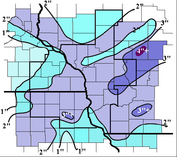 |
| Fig 1. Ice accumulations from February 21-23, 1922. |
According to the February 1922 Monthly Weather Review, a mixture of rain, sleet, and freezing rain fell across the southern two tiers of counties in Wisconsin. Further north, a mixture of freezing rain and sleet was seen north and west of a line from Prairie du Chien to Sheboygan and south of a line from Lake City, MN to Green Bay, WI. Ice accumulations of 1-2" were common in this area. Meanwhile, the remainder of Wisconsin saw a mix of sleet and heavy snow. Snowfall totals up to 3 feet were reported from Eau Claire to Green Bay.
In Wisconsin, the heavy ice accumulation brought down 15,000-20,000 communication poles. This resulted in interruptions of power, telegraph, and phone service from 2 to 15 days. In addition to the poles, there was considerable damage to timber, shade, and fruit trees. Ice accumulation on train tracks accounted for ten train wrecks as locomotives and cars slid off of their tracks. Minor flooding was reported in La Crosse, Sheboygan, Darlington, Fond du Lac, and a suburb in Milwaukee. This flooding caused considerable inconvenience, but little monetary loss. Fortunately, only two deaths were attributed to this storm.
Our Office
Staff
Want a tour?
Looking for a speaker?
Community Involvement
Station / Location Info
Follow Us On Social Media
Weather Safety
SkyWarn
Preparedness
Preparedness (En Espanol)
Weather Radio
StormReady
WRN Ambassadors
Additional Information
Storm Summaries
Cooperative Observers
Educational Resources
Science / Research
Weather Phenomenon
Mayfly Tracking
Latest
Temp/Pcpn Summary
Precipitation Reports
Forecast Discussion
Hazardous Weather Outlook
Hourly Weather
Public Information Statement
Local Storm Report
Lightning Plot Archive
River Stages
Water Temp
Observations
Precipitation Plotter
Soil Temps
US Dept of Commerce
National Oceanic and Atmospheric Administration
National Weather Service
La Crosse, WI
N2788 County Road FA
LaCrosse, WI 54601
608-784-7294
Comments? Questions? Please Contact Us.

