A hourly weather graph forecast can be generated by going to the Hourly Graph website.
Guide to decoding the forecast below.
000
FNUS81 KBGM 020902
FWMBGM
FCST,301011,240502,13,1,76,33,1,1,NW,11,,80,55,83,31,0,0,N
FCST,301011,240503,13,1,79,35,1,1,S,06,,79,45,93,29,0,0,N
FCST,301011,240504,13,2,61,67,1,1,S,14,,81,51,86,32,0,0,N
FCST,301011,240505,13,2,63,70,1,2,S,14,,65,49,96,62,0,0,N
FCST,301011,240506,13,1,70,47,2,2,NW,10,,72,52,96,46,0,0,N
FCST,301011,240507,13,1,75,47,1,1,SW,10,,76,49,93,39,0,0,N
FCST,301011,240508,13,2,76,58,1,2,WSW,20,,79,57,93,44,0,0,N
FCST,300171,240502,13,1,66,45,1,1,WNW,13,,72,54,86,45,0,0,N
FCST,300171,240503,13,1,71,44,1,1,SSE,05,,73,45,96,40,0,0,N
FCST,300171,240504,13,2,61,62,1,1,SSE,13,,74,50,83,39,0,0,N
FCST,300171,240505,13,2,55,80,1,2,S,17,,64,46,96,58,9,6,N
FCST,300171,240506,13,1,65,54,2,2,WNW,11,,67,50,96,54,0,0,N
FCST,300171,240507,13,1,70,46,1,1,WSW,10,,72,46,89,45,0,0,N
FCST,300171,240508,13,2,70,67,1,2,SW,17,,74,54,93,45,0,0,N
FCST,361802,240502,13,1,79,31,1,1,WNW,09,,80,53,93,30,0,0,N
FCST,361802,240503,13,1,70,47,1,1,SE,04,,81,49,89,28,0,0,N
FCST,361802,240504,13,2,62,52,1,1,SSE,10,,72,47,86,42,0,0,N
FCST,361802,240505,13,2,56,74,1,2,SSE,11,,64,46,96,48,0,5,N
FCST,361802,240506,13,1,72,48,2,2,WNW,11,,73,51,96,46,0,0,N
FCST,361802,240507,13,1,75,45,1,1,WSW,10,,76,51,93,41,0,0,N
FCST,361802,240508,13,2,75,56,1,2,SW,17,,78,57,93,43,0,0,N
FCST,360791,240502,13,1,74,36,1,1,WNW,12,,76,54,86,34,0,0,N
FCST,360791,240503,13,1,68,51,1,1,SSE,06,,77,47,86,31,0,0,N
FCST,360791,240504,13,2,56,64,1,1,SSE,14,,71,45,86,46,0,0,N
FCST,360791,240505,13,2,53,82,1,2,SSE,13,,58,44,96,62,0,6,N
FCST,360791,240506,13,1,67,55,2,2,WNW,11,,68,50,100,54,0,0,N
FCST,360791,240507,13,1,70,52,1,1,WSW,11,,71,49,93,47,0,0,N
FCST,360791,240508,13,2,72,62,1,2,SW,18,,73,56,93,51,0,0,N
FCST,360792,240502,13,0,78,32,1,1,WNW,10,,81,56,83,29,0,0,N
FCST,360792,240503,13,1,73,43,1,1,SSE,06,,82,50,80,27,0,0,N
FCST,360792,240504,13,2,60,61,1,1,SSE,13,,76,46,83,39,0,0,N
FCST,360792,240505,13,2,57,78,1,2,SSE,12,,64,45,93,54,0,6,N
FCST,360792,240506,13,1,70,53,2,2,WNW,10,,73,51,100,49,0,0,N
FCST,360792,240507,13,1,74,50,1,1,WSW,10,,76,50,90,45,0,0,N
FCST,360792,240508,13,2,75,59,1,2,SW,18,,78,58,90,47,0,0,N
FCST,360151,240502,13,1,76,34,1,1,NW,09,,77,57,80,33,0,0,N
FCST,360151,240503,13,1,76,39,1,1,S,04,,78,48,89,32,0,0,N
FCST,360151,240504,13,2,60,67,1,1,SSE,13,,78,49,83,36,0,0,N
FCST,360151,240505,13,2,58,80,1,2,S,13,,61,48,96,64,9,6,N
FCST,360151,240506,13,1,70,53,2,2,WNW,10,,70,53,100,51,0,0,N
FCST,360151,240507,13,1,74,50,1,1,SW,10,,74,50,96,46,0,0,N
FCST,360151,240508,13,2,75,58,1,2,SW,19,,77,58,96,48,0,0,N
FCST,361031,240502,13,1,78,32,1,1,WNW,10,,79,53,93,31,0,0,N
FCST,361031,240503,13,1,69,49,1,1,SE,05,,80,48,89,29,0,0,N
FCST,361031,240504,13,2,60,57,1,1,SSE,11,,71,45,93,44,0,0,N
FCST,361031,240505,13,2,55,79,1,2,SSE,11,,61,44,100,53,0,6,N
FCST,361031,240506,13,1,71,51,2,2,WNW,11,,71,50,100,49,0,0,N
FCST,361031,240507,13,1,74,48,1,1,WSW,10,,74,50,96,46,0,0,N
FCST,361031,240508,13,2,74,59,1,2,SW,17,,75,56,96,46,0,0,N
FCST,300971,240502,13,1,69,42,1,1,NW,13,,72,54,83,40,0,0,N
FCST,300971,240503,13,1,74,40,1,1,SSE,08,,74,47,89,38,0,0,N
FCST,300971,240504,13,2,58,72,1,2,SSE,21,,76,53,77,37,0,0,N
FCST,300971,240505,13,2,60,75,2,2,S,18,,60,49,93,67,0,0,N
FCST,300971,240506,13,1,65,55,2,2,NW,11,,65,50,93,54,0,0,N
FCST,300971,240507,13,1,70,50,1,1,SW,10,,71,48,89,47,0,0,N
FCST,300971,240508,13,2,72,63,1,2,WSW,19,,73,56,90,48,0,0,N
000
FNUS51 KBGM 020901
FWFBGM
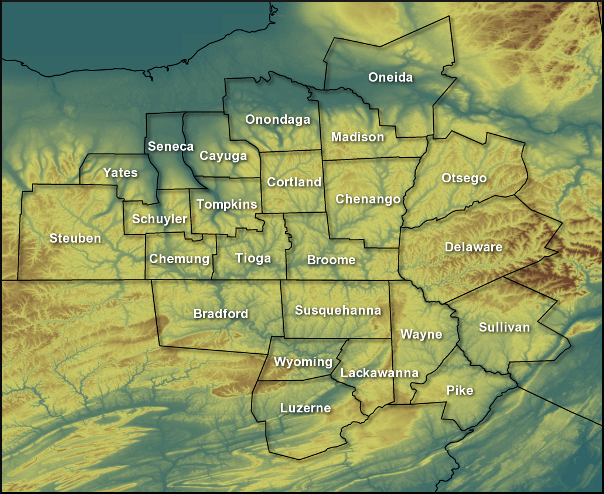
Fire Weather Planning Forecast for Central NY/Northeast PA
National Weather Service Binghamton NY
500 AM EDT Thu May 2 2024
.SYNOPSIS...
Dry weather has returned thru Friday. Temperatures will remain
above average for early May. Then, a brief cool down with
periods of rain showers is expected for the upcoming weekend.
NYZ210-022000-
Leatherstocking-
500 AM EDT Thu May 2 2024
Today Tonight Fri
Cloud Cover Mclear Mclear Pcldy
Precip Type None None None
Chance Precip (%) 0 0 0
Temp (24h trend) 70 (-1) 45 (-8) 74
RH % (24h trend) 32 (-5) 100 (0) 35
20ft Wnd-Val/AM(mph) W 8-12 G18 Lgt/Var
20ft Wnd-Rdg/PM(mph) NW 11-15 NW 3-7 SE 4-8
Precip Amount 0.00 0.00 0.00
Precip Duration
Precip Begin
Precip End
Mixing Hgt(ft-agl/msl)4770 4560
Transport Wnd (mph) NW 23 S 9
Vent Rate (kt-ft) 128030 46120
DSI 2 2 2
Sunshine Hours 11 9
LAL No tstms No tstms No tstms
Haines Index 3 4 4
ADI early 77 Good 51 Gen Good 28 Fair
ADI late 95 Good 3 Very Poor 45 Gen Good
Max LVORI early 4 3 8
Max LVORI late 1 7 1
Remarks: ADI is Atmospheric Dispersion Index by Lavdas.
LVORI is Low Visibility Occurrence Risk Index.
.FORECAST FOR DAYS 3 THROUGH 7...
.SATURDAY...Mostly cloudy with a 50 percent chance of showers.
Lows around 50. Highs in the lower 60s. Southeast winds 10 to
15 mph.
.SUNDAY...Mostly cloudy with showers likely and a slight chance
of thunderstorms. Lows in the upper 40s. Highs in the upper 50s.
Chance of precipitation 70 percent. Southeast winds around
15 mph.
.MONDAY...Mostly cloudy. A chance of showers and a slight chance
of thunderstorms. Lows in the lower 50s. Highs in the upper 60s.
Chance of precipitation 50 percent. Southwest winds around
10 mph.
.TUESDAY...Partly cloudy. A 40 percent chance of showers. Lows in
the upper 40s. Highs in the mid 70s. West winds 5 to 10 mph.
.WEDNESDAY...Mostly cloudy. Showers likely and a slight chance of
thunderstorms. Lows in the mid 50s. Highs in the lower 70s.
Chance of precipitation 70 percent. South winds 10 to 15 mph.
$$
PAZ038-039-043-022000-
Bradford-Susquehanna-Wyoming-
Including the cities of Sayre, Towanda, Hallstead, Montrose,
and Tunkhannock
500 AM EDT Thu May 2 2024
Today Tonight Fri
Cloud Cover Mclear Mclear Mclear
Precip Type None None None
Chance Precip (%) 0 0 0
Temp (24h trend) 76 (+1) 46 (-8) 77
RH % (24h trend) 29 (-6) 96 (-4) 35
20ft Wnd-Val/AM(mph) W 5-9 Lgt/Var
20ft Wnd-Rdg/PM(mph) NW 9-13 N 4-8 S 4-8
Precip Amount 0.00 0.00 0.00
Precip Duration
Precip Begin
Precip End
Mixing Hgt(ft-agl/msl)5270 4760
Transport Wnd (mph) NW 21 S 10
Vent Rate (kt-ft) 99920 47870
DSI 3 2 2
Sunshine Hours 12 10
LAL No tstms No tstms No tstms
Haines Index 4 5 5
ADI early 70 Good 66 Good 30 Fair
ADI late 102 Very Good3 Very Poor 56 Gen Good
Max LVORI early 4 3 6
Max LVORI late 1 6 1
Remarks: ADI is Atmospheric Dispersion Index by Lavdas.
LVORI is Low Visibility Occurrence Risk Index.
.FORECAST FOR DAYS 3 THROUGH 7...
.SATURDAY...Mostly cloudy with a 50 percent chance of showers.
Lows in the upper 40s. Highs around 60. Southeast winds 10 to
15 mph.
.SUNDAY...Mostly cloudy with showers likely and a slight chance
of thunderstorms. Lows in the upper 40s. Highs in the upper 50s.
Chance of precipitation 70 percent. Southeast winds around
15 mph.
.MONDAY...Mostly cloudy. A chance of showers and a slight chance
of thunderstorms. Warmer. Lows in the lower 50s. Highs in the
lower 70s. Chance of precipitation 50 percent. West winds around
10 mph.
.TUESDAY...Partly cloudy. A 40 percent chance of showers. Lows in
the upper 40s. Highs in the mid 70s. North winds 5 to 10 mph.
.WEDNESDAY...Mostly cloudy. Showers likely and a slight chance of
thunderstorms. Lows in the upper 50s. Highs in the mid 70s.
Chance of precipitation 70 percent. South winds 10 to 15 mph.
$$
PAZ044-047-022000-
Lackawanna-Luzerne-
Including the cities of Scranton, Hazleton, and Wilkes-Barre
500 AM EDT Thu May 2 2024
Today Tonight Fri
Cloud Cover Mclear Mclear Mclear
Precip Type None None None
Chance Precip (%) 0 0 0
Temp (24h trend) 80 (+4) 48 (-8) 75
RH % (24h trend) 27 (-7) 89 (-11) 37
20ft Wnd-Val/AM(mph) W 4-8 Lgt/Var
20ft Wnd-Rdg/PM(mph) NW 9-13 N 5-9 SE 4-8
Precip Amount 0.00 0.00 0.00
Precip Duration
Precip Begin
Precip End
Mixing Hgt(ft-agl/msl)5670 4500
Transport Wnd (mph) NW 20 S 9
Vent Rate (kt-ft) 99660 39690
DSI 3 2 2
Sunshine Hours 12 10
LAL No tstms No tstms No tstms
Haines Index 4 5 5
ADI early 67 Good 65 Good 28 Fair
ADI late 99 Good 4 Very Poor 51 Gen Good
Max LVORI early 4 3 4
Max LVORI late 1 4 1
Remarks: ADI is Atmospheric Dispersion Index by Lavdas.
LVORI is Low Visibility Occurrence Risk Index.
.FORECAST FOR DAYS 3 THROUGH 7...
.SATURDAY...Mostly cloudy with a 50 percent chance of showers.
Lows in the upper 40s. Highs in the lower 60s. Southeast winds
10 to 15 mph.
.SUNDAY...Mostly cloudy with showers likely and a slight chance
of thunderstorms. Lows in the upper 40s. Highs in the upper 50s.
Chance of precipitation 70 percent. Southeast winds around
15 mph.
.MONDAY...Mostly cloudy. A chance of showers and a slight chance
of thunderstorms. Warmer. Lows in the lower 50s. Highs in the
lower 70s. Chance of precipitation 50 percent. West winds around
10 mph.
.TUESDAY...Partly cloudy. A 40 percent chance of showers. Lows in
the lower 50s. Highs in the mid 70s. Northeast winds 5 to 10 mph.
.WEDNESDAY...Mostly cloudy. Showers likely and a slight chance of
thunderstorms. Lows in the upper 50s. Highs in the upper 70s.
Chance of precipitation 60 percent. South winds 10 to 15 mph.
$$
PAZ040-048-072-022000-
Northern Wayne-Pike-Southern Wayne-
Including the cities of Damascus, Equinunk, Milford,
and Honesdale
500 AM EDT Thu May 2 2024
Today Tonight Fri
Cloud Cover Mclear Mclear Pcldy
Precip Type None None None
Chance Precip (%) 0 0 0
Temp (24h trend) 77 (+3) 46 (-7) 71
RH % (24h trend) 27 (-5) 96 (-4) 41
20ft Wnd-Val/AM(mph) W 5-9 Lgt/Var
20ft Wnd-Rdg/PM(mph) NW 9-13 N 5-9 SE 4-8
Precip Amount 0.00 0.00 0.00
Precip Duration
Precip Begin
Precip End
Mixing Hgt(ft-agl/msl)5570 4130
Transport Wnd (mph) NW 22 SE 9
Vent Rate (kt-ft) 104030 40870
DSI 2 2 2
Sunshine Hours 12 9
LAL No tstms No tstms No tstms
Haines Index 4 5 5
ADI early 82 Good 59 Gen Good 29 Fair
ADI late 91 Good 4 Very Poor 45 Gen Good
Max LVORI early 5 3 6
Max LVORI late 1 6 1
Remarks: ADI is Atmospheric Dispersion Index by Lavdas.
LVORI is Low Visibility Occurrence Risk Index.
.FORECAST FOR DAYS 3 THROUGH 7...
.SATURDAY...Mostly cloudy with a 50 percent chance of showers.
Lows in the mid 40s. Highs in the lower 60s. Southeast winds
around 10 mph.
.SUNDAY...Mostly cloudy with showers likely and a slight chance
of thunderstorms. Lows in the mid 40s. Highs in the mid 50s.
Chance of precipitation 70 percent. Southeast winds around
15 mph.
.MONDAY...Mostly cloudy. A chance of showers and a slight chance
of thunderstorms. Warmer. Lows in the lower 50s. Highs in the
lower 70s. Chance of precipitation 40 percent. Northwest winds
around 10 mph.
.TUESDAY...Partly cloudy. A 40 percent chance of showers. Lows in
the upper 40s. Highs in the mid 70s. Northwest winds 5 to 10 mph.
.WEDNESDAY...Mostly cloudy. Showers likely and a slight chance of
thunderstorms. Lows in the mid 50s. Highs in the mid 70s. Chance
of precipitation 70 percent. South winds 10 to 15 mph.
$$


 Follow us on YouTube