
Isolated strong to severe thunderstorms are possible in parts of the Midwest and the south-central Plains. Heavy rainfall pose a risk of flash flooding in the Desert Southwest and northeast New Mexico, especially in burn scars, and in the urban corridor of southeast Florida. Read More >
Overview
|
On December 30, 2021 the devastating Marshall Fire roared through Superior and portions of Louisville, Colorado. The fire started south of Boulder, Colorado, and was fanned by intense winds along the Front Range Foothills. Wind gusts from 70 to 100 mph occurred right at the base of the foothills, including Boulder and along Highway 93 south toward Golden. The strong winds fanned a grass fire which originated near the small town of Marshall, and quickly spread east to Superior and Louisville. At last count, 1,084 homes and seven commercial structures were destroyed, and 149 homes and another 30 commercial structures were damaged by the Marshall Fire. |
Credit: NOAA/NWS Boulder |
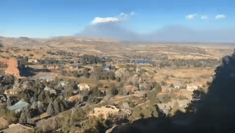
Video of Marshall Fire from NWS Boulder at approximately 11:55 am MST 12/30/2021. Credit: NOAA/NWS Boulder
Environment
High winds developed in the mid morning hours on Thursday, December 30th, 2021, the result of a mountain wave that developed as very strong westerly winds raced over the Front Range Mountains and Foothills and crashed down onto the plains. The mountain wave remained nearly unchanged through the rest of the day, resulting in very persistent and extremely high winds. Mountain waves are usually focused very close to the base of the foothills and adjacent plains. On this day, sustained winds of 50 to 60 mph with gusts of 80 to 100 mph were felt along Highway 93 and points east to around Superior and at times, Louisville. It takes just the right combination of meteorological parameters, including stability, wind shear, and wind magnitude to create a powerful and damaging windstorm like this one. To further visualize what a mountain wave would look like, see Figure 1 below.
The schematic in Figure 1 represents the strong westerly winds moving down the mountain slope (in this case the Front Range Mountains and Foothills) and accelerating all the way to the base of the foothills. From there, they spread east into the Superior and Louisville area, before suddenly weakening to the east (call the jump region). It was interesting to note in this case, that easterly winds were observed at times immediately to the east of the "jump" area around Broomfield and Lafayette. This can also be referred to as a rotor.
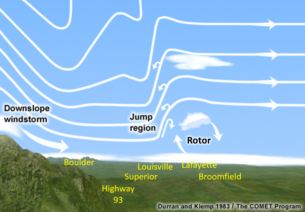
Figure 1: Conceptual Model of a mountain wave.
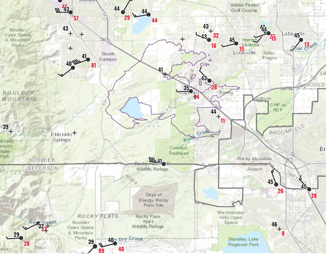
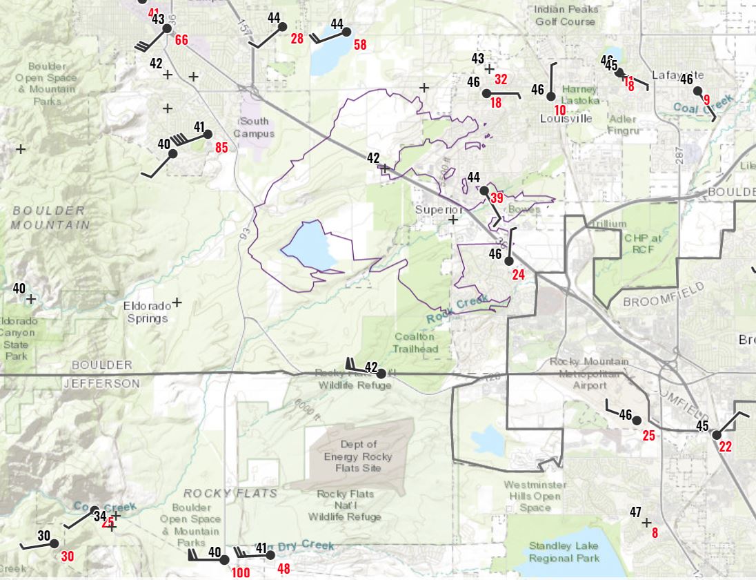
Figures 2 through 4 show the progression of winds and fire during the late morning and afternoon hours of December 30. The eventual fire perimeter is outlined by light purple (upper center of the plot images), while the city of Boulder is located in the northwest corner of these images. At 11 AM MST, (Figure 2), winds were gusting to 81 mph in south Boulder, while as high as 99 mph near the intersection of Highway 93 and Highway 72 (Coal Creek Canyon). The surface plot for 12 PM MST (Figure 3) shows some of the strongest winds from this wind event. A peak gust of 115 mph reported at the base of the foothills, just east of the intersection of Highway 93 and Highway 72. Note the 85 mph gust in south Boulder, and 100 mph gust along Highway 93 (very bottom of the image below) near the top of the hour. Between 12 noon and 2 pm, the stronger winds were shifting slightly east, through all of Superior and most of Louisville. At 2 pm (Figure 4) a wind gust to 68 mph was recorded near Coal Creek Golf Course in Louisville, a community that would see devastation with hundreds of homes burned. The fire had already moved through much of Superior, and was spreading quickly through the Louisville area.
 |
 |
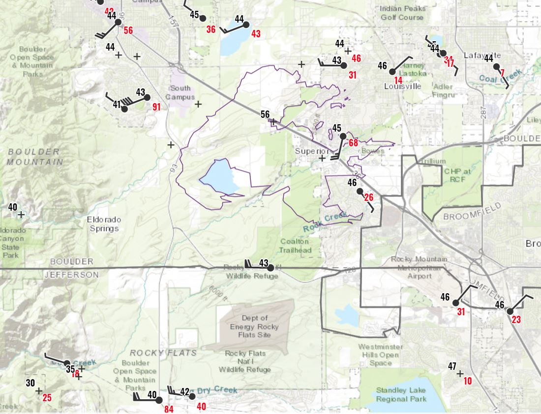 |
| Figure 2: 11 AM MST surface plot showing wind gusts in red, temperature in black. | Figure 3: 12 PM MST surface plot, showing wind gusts in red, temperature in black. | Figure 4: 2 PM MST surface plot showing wind gusts in red, temperature in black. |
Drought Conditions contributing to the fire danger
The second recipe ingredient for this disaster was the lack of precipitation during the latter half of the year. The Front Range experienced a very wet first half of the year, with much above normal precipitation and lush, tall grass growth. However, starting around July, a persistently dry weather pattern set up and held firm through the entire fall and early winter. Vegetation, while typically dry this time of year, was exceptionally dry as very little precipitation had fallen through the entire fall season.
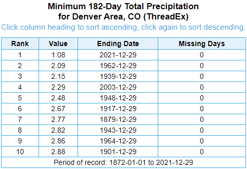
The strong winds and low humidity that day quickly dried the fine grasses, and preceding drought conditions ensured larger fuels such as shrubs and trees (plentiful in and around the affected subdivisions) were likewise critically dry. Below, are the July 1 through December 29 temperature (Figure 5) and precipitation (Figure 6) ranks, showing Denver being the 2nd warmest, and by far the driest in recorded history (since 1872). Boulder was ranked 2nd warmest and 13th driest in recorded history. Another way to visualize the severity of warm and dry conditions is shown in Figure 7, which combines temperature and precipitation in one graphic. June 1 to December 2021 at Denver Central Park is plotted in the upper left, which indicates this period had the the most extreme combination of warmth and dryness compared to past years. For information on the wet and dry pattern can be found on climate.gov.
 |
 |
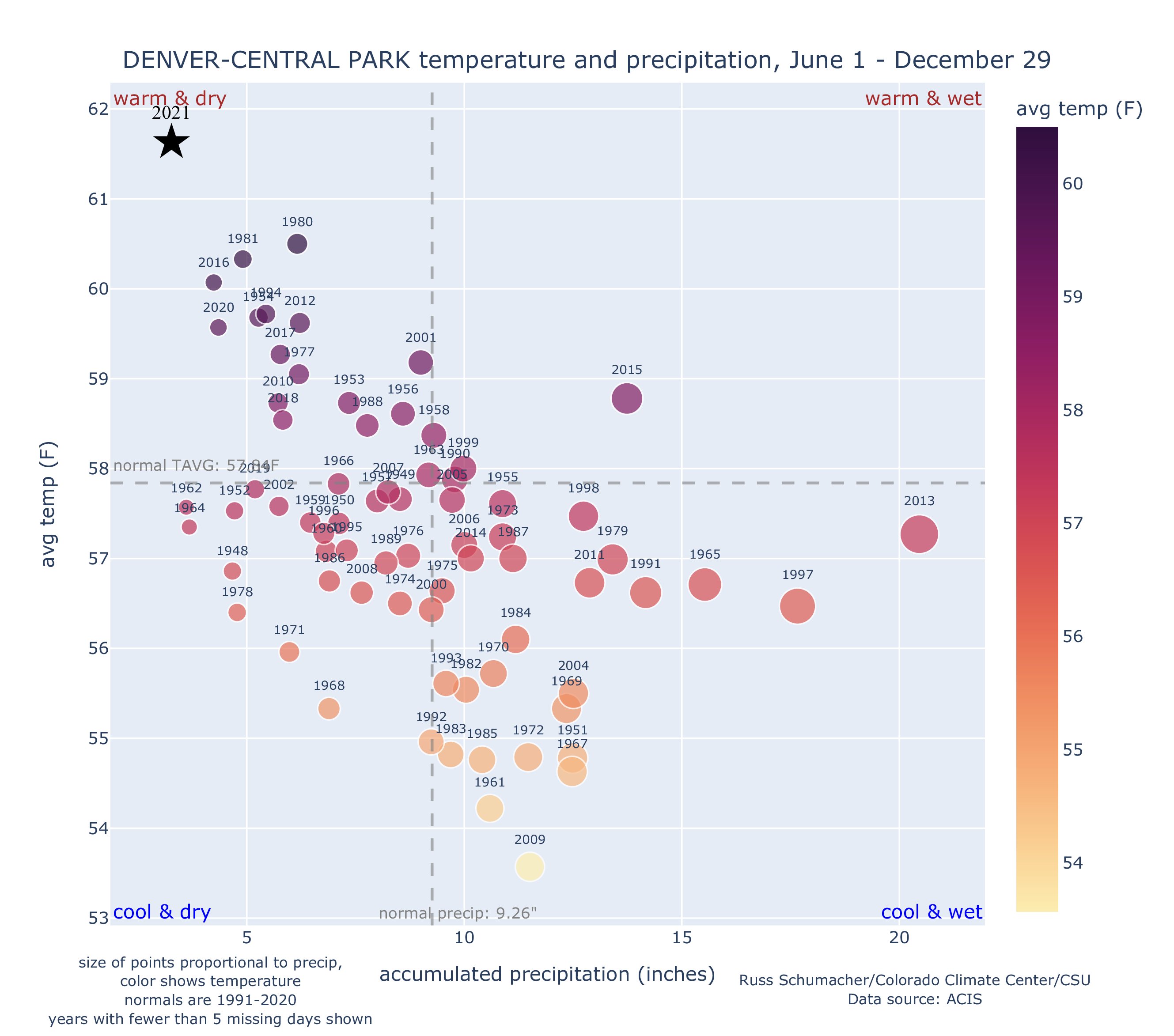 |
| Figure 5: Rankings for July1 through December 29 average temperature. 2021 was second warmest on record. | Figure 6: Rankings for July1 through December 29 precipitation. 2021 was driest on record. | Figure 7: Quardrant chart showing the relative combination of temperature and precipitation to previous years, at Denver Central Park. Credit: Russ Schumacher/Colorado Climate Center |
The Marshall Fire
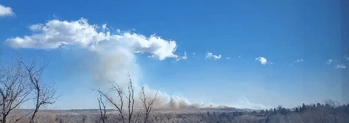
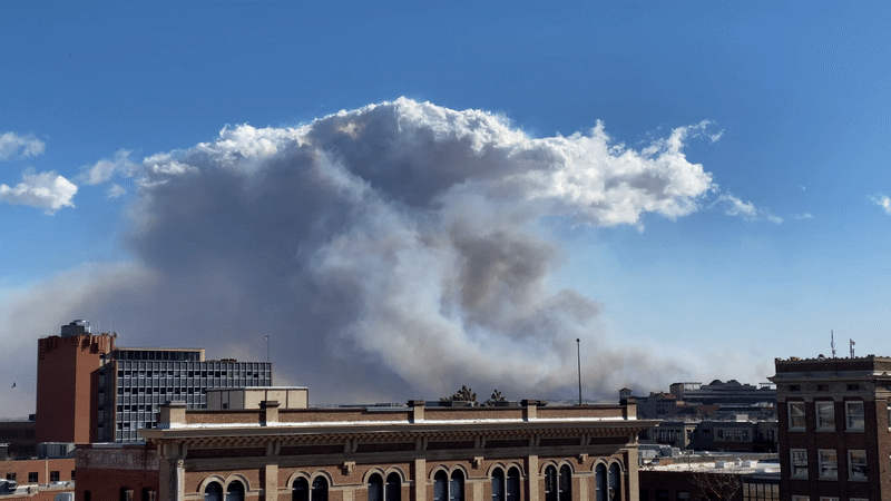
The fire started shortly after 11 am and raced quickly eastward, fed by the mountain wave induced wind gusts of 80 to 100 mph and extremely dry grasses. The downslope portion of the wind storm held the strongest winds and smoke very near the surface. Smoke then rose vertically in the hydraulic jump region (see Meteorology of High Winds tab) of the mountain wave, indicated by the a linear and nearly stationary cap of clouds. This region of rising smoke also roughly indicates the eastward extent of the very strong west winds. Time lapse video in Figure 8 helps to visualize the flow in the mountain wave, with strong winds crashing to the ground from Highway 93 east toward the Davidson Mesa and Superior, before then flowing upward in vertical in the "jump" area seen in the schematic in Figure 1. This view gives us a mirror-like image to the mountain wave schematic in Figure 1, since we're now looking south toward the wave rather than north as in the conceptual diagram.
By early afternoon, the mountain wave was fully established and clearly visible in the smoke and cloud structure. Time lapse imagery in Figure 9 taken from the southwest side of the Denver metro area was shared by Mike Nelson and Mario Gori, showing the fluidity of the mountain wave. Note the reflection shown in the strongest first wave, and then the subsequent second and even third wave on the far right of the imagery. Smoke is clearly visible as gray, while clouds are also shown on the crest of the wave where upward vertical motion was maximized above the "jump" area.
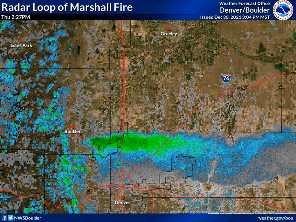
Figure 10 and 11 display remote sensing of the fire and its smoke and ash plume. Figure 10, the radar loop displays radar returns from the fire (smoke and ash), being lofted far into the atmosphere and thrown east across Denver International Airport and the eastern Colorado Plains. Figure 11 shows the heat signature, viewable from the GOES-16 satellite from a vantage point of 22,000 miles up in space.
 |
 |
 |
 |
| Figure 8: Marshall Fire smoke from Boulder 1210 PM MST 12/30/2021. Credit Twitter user @Boldmethod, for research and event documentation only. | Figure 9: Marshall Fire smoke from west Denver Metro 12/30/2021. Credit Mike Nelson & Mario Gori, for research and event documentation only. | Figure 10: Radar Loop of Marshall Fire. | Figure 11: Satellite Loop of Marshall Fire |
Radar Imagery from KFTG
Here is the reflectivity and Doppler Velocity from KFTG from 11:28 AM through 8:03 PM MST on 12/30/2021
Highest Wind Reports
Location                     Speed     Time/Date       Lat/Lon

...Colorado...

...Adams County...
0.7 Mi S Of Northwest Pkwy   56 MPH    1235 PM 12/30   39.97N/104.99W

...Boulder County...
3 SSW Boulder                108 MPH   0225 PM 12/30   39.99N/105.27W
1 NE Crisman                 102 MPH   1120 AM 12/30   40.05N/105.35W
3 NW Marshall                90 MPH    0125 PM 12/30   39.98N/105.28W
Boulder                      75 MPH    0215 PM 12/30   40.03N/105.23W
036e03750rws1rp1 At Baseline 73 MPH    1123 AM 12/30   40.00N/105.26W
Wondervu                     72 MPH    0956 AM 12/30   39.91N/105.38W
Atoc - Univ. Colorado Campus 71 MPH    1050 AM 12/30   40.01N/105.27W
Lyons 3W                     70 MPH    1042 AM 12/30   40.22N/105.33W
Lafayette                    70 MPH    1001 AM 12/30   40.06N/105.12W
Louisville                   68 MPH    0200 PM 12/30   39.96N/105.15W
Longmont                     68 MPH    1147 AM 12/30   40.13N/105.23W
Nederland                    66 MPH    0900 AM 12/30   39.99N/105.45W
Nederland                    65 MPH    0938 AM 12/30   39.99N/105.45W
Boulder                      64 MPH    0325 PM 12/30   40.06N/105.29W
Boulder                      64 MPH    1117 AM 12/30   40.04N/105.26W
Boulder                      63 MPH    1116 AM 12/30   40.02N/105.29W
Boulder                      62 MPH    0223 PM 12/30   40.06N/105.21W
Boulder                      61 MPH    1042 AM 12/30   40.00N/105.20W
Ward                         60 MPH    0833 AM 12/30   40.10N/105.50W
Boulder                      57 MPH    0808 AM 12/30   40.03N/105.28W

...Broomfield County...
025s229 Sh7                  57 MPH    1153 AM 12/30   40.00N/104.98W

...Clear Creek County...
Corral Creek                 67 MPH    1158 AM 12/30   39.64N/105.46W
I-70 Georgetown Lake         61 MPH    1235 PM 12/30   39.73N/105.69W
I-70 Floyd Hill              60 MPH    1204 PM 12/30   39.72N/105.41W

...Douglas County...
Cheesman                     67 MPH    1223 PM 12/30   39.18N/105.27W
Carpenter Peak               56 MPH    0357 PM 12/30   39.42N/105.08W
Franktown                    56 MPH    0320 PM 12/30   39.39N/104.75W
Surrey Ridge                 55 MPH    1224 PM 12/30   39.49N/104.87W

...Elbert County...
Elizabeth                    60 MPH    0250 PM 12/30   39.35N/104.53W

...Gilpin County...
Black Hawk                   58 MPH    1253 PM 12/30   39.84N/105.47W
Dakota Hill                  58 MPH    0955 AM 12/30   39.87N/105.55W
Aspen Springs                57 MPH    1250 PM 12/30   39.83N/105.48W
Golden                       56 MPH    1131 AM 12/30   39.90N/105.40W

...Grand County...
Winter Park Eagle Wind       73 MPH    0345 AM 12/30   39.85N/105.78W
Berthoud Pass                63 MPH    0935 AM 12/30   39.80N/105.77W
Keyser Ridge                 55 MPH    0427 AM 12/30   39.89N/106.04W

...Jefferson County...
Arvada                       115 MPH   1206 PM 12/30   39.86N/105.22W
Rocky Flats Hwy 93 and 72    110 MPH   1123 AM 12/30   39.87N/105.24W
2.8 NE White Ranch Open Spac 103 MPH   0126 PM 12/30   39.85N/105.25W
2 NW Rocky Flats             98 MPH    1155 AM 12/30   39.91N/105.23W
470w014 Wadsworth            81 MPH    0348 PM 12/30   39.55N/105.08W
1.7 NE Rocky Flats (CDPHE)   78 MPH    1215 PM 12/30   39.91N/105.19W
I-70 at C470                 73 MPH    1224 PM 12/30   39.71N/105.19W
Genesee                      71 MPH    1212 PM 12/30   39.71N/105.29W
Coal Creek Canyon            69 MPH    1016 AM 12/30   39.88N/105.39W
Lakewood                     67 MPH    0346 PM 12/30   39.70N/105.15W
Golden                       66 MPH    0901 AM 12/30   39.79N/105.28W
Arvada                       62 MPH    0146 PM 12/30   39.84N/105.17W
Arvada                       62 MPH    0139 PM 12/30   39.85N/105.16W
Littleton                    56 MPH    0316 PM 12/30   39.59N/105.13W
4 SSE Rocky Flats            55 MPH    0230 PM 12/30   39.83N/105.19W

...Larimer County...
Glen Haven                   89 MPH    0827 AM 12/30   40.47N/105.45W
Livermore                    79 MPH    0846 AM 12/30   40.71N/105.41W
Lyons                        62 MPH    1156 AM 12/30   40.28N/105.31W
Virginia Dale                62 MPH    1134 AM 12/30   40.95N/105.35W
Buckeye                      60 MPH    0235 PM 12/30   40.81N/105.04W
Red Feather RAWS             58 MPH    1224 PM 12/30   40.80N/105.57W
Livermore                    57 MPH    0933 AM 12/30   40.87N/105.36W
3 WNW Loveland               56 MPH    0217 PM 12/30   40.43N/105.12W

...Summit County...
Red Cliff Pass               55 MPH    0515 AM 12/30   39.48N/106.15W

...Weld County...
Erie Muni                    59 MPH    0915 AM 12/30   40.02N/105.05W

Observations are collected from a variety of sources with varying
equipment and exposures. We thank all volunteer weather observers
for their dedication. Not all data listed are considered official.
 |
Media use of NWS Web News Stories is encouraged! Please acknowledge the NWS as the source of any news information accessed from this site. |
|


.JPG)