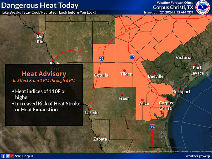
National Weather Service United States Department of Commerce

Heavy Rain and Flash Flooding Threat in Montana; Severe Thunderstorms in the Middle Missouri Valley

A low pressure system will bring heavy to excessive rainfall and high winds across Montana this afternoon. Heavy rainfall totals may lead to scattered flash flooding concerns. A line of showers and strong to severe thunderstorms will move into the mid Missouri Valley region this afternoon producing severe winds and isolated large hail with stronger storms. Read More >

Click a location below for detailed forecast.

Last Map Update: Wed, Sep 18, 2024 at 6:52:09 pm CDT

There are no watches, warnings, or advisories at this time.

It will be mostly sunny and warm across South Texas today, with highs in the upper 80s to upper 90s. A few showers will be possible, mainly along the sea breeze, but the chance is less than a 20%. Winds will be out of the southeast at 10-15 mph.
Warm today across area beaches with a light southeasterly wind. There is a LOW risk of rip currents, but remember, a low risk doesn't mean no risk. Dangerous swimming conditions may still exist especially near piers and jetties.
It will be mostly clear to partly cloudy and warm tonight. Overnight lows will be in the mid 70s to low 80s range. Winds will be light and variable. A few locations along the Coastal Plains may experience some patchy fog after midnight.
Seasonal conditions continue through the next 5 days. We'll be mainly dry, but an isolated shower is not out of the question.

 
Hourly Weather Roundup ( )
Location Sky/Weather Temp Dewpt RH Wind Baro Remarks
Alice
N/A
N/A
N/A
N/A
N/A
N/A
N/A
Beeville
N/A
N/A
N/A
N/A
N/A
N/A
N/A
Corpus Christi
N/A
N/A
N/A
N/A
N/A
N/A
N/A
Corpus Christi NAS
N/A
N/A
N/A
N/A
N/A
N/A
N/A
Cotulla
N/A
N/A
N/A
N/A
N/A
N/A
N/A
Kingsville NAS
N/A
N/A
N/A
N/A
N/A
N/A
N/A
Laredo
N/A
N/A
N/A
N/A
N/A
N/A
N/A
Port Lavaca
N/A
N/A
N/A
N/A
N/A
N/A
N/A
Rockport
N/A
N/A
N/A
N/A
N/A
N/A
N/A
Victoria
N/A
N/A
N/A
N/A
N/A
N/A
N/A
Note: "N/A" or "MISG" will be displayed if values are not available. In the LOCATION column, click on links for a list of recent observations at sites of interest. In the WIND column, VRB is "variable" and G is "gust". Wind speeds are in MPH. In the BARO (pressure) column, values are in inches. In the REMARKS column, HX is "heat index", WCI is "wind chill index", and VSB is "visibility" (if shown).
 
Text Product Selector
Video Briefing Weather Outlook Fcst Discussion Tropical Marine Tides
Rivers and Lakes Daily Rainfall Drought Fire Observations Satellite

Hourly Wx Graph Graphical Fcst Aviation Climate Past Events Hurricane Guide