| CONTENT
- a. Identify weather instruments and explain how each is used in gathering weather data and making forecasts (thermometer, rain gauge, barometer, wind vane, anemometer).
- https://www.isws.illinois.edu/statecli/instruments/weather_instruments.htm
- b. Using a weather map, identify the fronts, temperature, and precipitation and use the information to interpret the weather conditions.
- Fronts... http://ww2010.atmos.uiuc.edu/(Gh)/guides/mtr/af/home.rxml
- https://eo.ucar.edu/kids/sky/air5.htm
- c. Use observations and records of weather conditions to predict weather patterns throughout the year.
- https://www.research.noaa.gov/k12/html/forecasting2.html
- d. Differentiate between weather and climate.
- What is climate? http://eo.ucar.edu/kids/green/what1.htm
TASKS
 Collect and chart weather data using weather instruments such as thermometer, wind vane, anemometer, barometer, and rain gauge. Compare data seasonally throughout the year to note changes of weather data. For example, you could graph the temperatures for a week in August or September, a week in November or December, a week in February or March, and a week in April or May and compare. Collect and chart weather data using weather instruments such as thermometer, wind vane, anemometer, barometer, and rain gauge. Compare data seasonally throughout the year to note changes of weather data. For example, you could graph the temperatures for a week in August or September, a week in November or December, a week in February or March, and a week in April or May and compare.- https://weather.gov/ffc/pastobs
- http://weather.uwyo.edu/surface/meteorogram/
 Use a wind sock, or make a wind speed detector. Tape strips of tissue paper to the end of a pencil. Hold it up to detect wind. A common wind speed instrument used to calculate wind speed is an anemometer. A common wind scale is Beaufort Wind Scale. Use a wind sock, or make a wind speed detector. Tape strips of tissue paper to the end of a pencil. Hold it up to detect wind. A common wind speed instrument used to calculate wind speed is an anemometer. A common wind scale is Beaufort Wind Scale.- Wind Speed Anemometer... https://en.wikipedia.org/wiki/Anemometer
- Beaufort Wind Scale... http://www.spc.noaa.gov/faq/tornado/beaufort.html
 Record the wind speed and direction for a period of time. Compare your data to the information given by weather forecasters in newspapers, radios, internet, and television reports. Record the wind speed and direction for a period of time. Compare your data to the information given by weather forecasters in newspapers, radios, internet, and television reports.- https://weather.gov/ffc/pastobs
 Cut a circle (10 cm diameter) out of paper. Cut the circle into a spiral. Tie a piece of thread to the middle end of the spiral of paper. Hold it over a heat source such as a light bulb. Note the movement. Move the spiral away from the heat source. Note the movement. Relate this movement of heated and cooled air to explain wind patterns. Cut a circle (10 cm diameter) out of paper. Cut the circle into a spiral. Tie a piece of thread to the middle end of the spiral of paper. Hold it over a heat source such as a light bulb. Note the movement. Move the spiral away from the heat source. Note the movement. Relate this movement of heated and cooled air to explain wind patterns.- https://www.weather.gov/jetstream/wind
Resource information:
Beaufort Wind Scale: https://www.stormfax.com/beaufort.htm
How to make an anemometer: https://www.teachengineering.org/activities/view/cub_energy2_lesson07_activity1
 Observe, record, and interpret weather conditions to predict weather patterns. Keep a class weather journal or class weather calendar periodically throughout the year: Observe, record, and interpret weather conditions to predict weather patterns. Keep a class weather journal or class weather calendar periodically throughout the year:- http://ww2010.atmos.uiuc.edu/(Gh)/guides/mtr/fcst/home.rxml
- http://ww2010.atmos.uiuc.edu/(Gh)/guides/mtr/fcst/sfc/ofrnt.rxml
-
-
- http://www.cpc.ncep.noaa.gov/
- https://weather.gov/ffc/outlooks
-
- Daily weather maps in a sequence to search for patterns
- http://www.wpc.ncep.noaa.gov/dailywxmap/index.html
- http://www.wpc.ncep.noaa.gov/dwm/dwm.shtml
- http://www.spc.noaa.gov/obswx/maps/
-
- Data you collect from weather instruments (thermometer, wind vane, rain gauge)
-
- Media weather reports (television, radio)
- Weather Channel https://weather.com
-
- Atlanta
- FOX5-TV https://www.fox5atlanta.com/weather
- WGCL-TV https://www.cbs46.com/weather/
- WSB-TV https://www.wsbtv.com/weather
- WSB Radio https://www.wsbradio.com/weather/
- WXIA-TV https://www.11alive.com/weather
- Augusta
- NBC-TV https://www.wrdw.com/nbc26
- WJBF-TV https://www.wjbf.com/weather/
- WRDW-TV https://www.wrdw.com/weather
- Columbus
- WLTZ-TV https://www.wltz.com/weather/
- WRBL-TV https://www.wrbl.com/weather/
- WTVM–TV https://www.wtvm.com/weather/
- Macon
- FOX24-TV https://wgxa.tv/weather
- WMAZ-TV https://www.13wmaz.com/weather
- WMGT-TV https://41nbc.com/
- WGXA-TV https://wgxa.tv/weather
- Savannah
- WSAV-TV https://www.wsav.com/weather/
- WTOC-TV https://www.wtoc.com/
-
- Events such as thunderstorms, tornadoes, hurricanes, blizzards, etc.
- Hurricanes http://www.nhc.noaa.gov/
- Thunderstorms/Tornadoes http://www.spc.noaa.gov/products/
- Georgia Thunderstorms/Tornadoes https://weather.gov/ffc/warnings
 Use the information you collect about weather events to inform others about severe weather and steps to take in the event of severe weather. Use the information you collect about weather events to inform others about severe weather and steps to take in the event of severe weather.- https://www.nssl.noaa.gov/edu/safety/
- https://www.redcross.org/disaster/safety/guide.html
- https://weather.gov/ffc/swaw08_main
 Chart and graph the weather data you collect. Match your findings with the data on other weather reports. Chart and graph the weather data you collect. Match your findings with the data on other weather reports.- https://scied.ucar.edu/webweather/thunderstorms/make-weather-forecast
 Use your observations, journal entries, weather maps, and other data to make predictions about the weather. Explain what information you used to make your prediction. Compare the accuracy of your predictions to the predictions of weather forecasters. Explain the similarities and differences of the predictions in terms of accuracy. Use your observations, journal entries, weather maps, and other data to make predictions about the weather. Explain what information you used to make your prediction. Compare the accuracy of your predictions to the predictions of weather forecasters. Explain the similarities and differences of the predictions in terms of accuracy.- https://scied.ucar.edu/webweather/thunderstorms/make-weather-forecast
 Construct simple weather instruments to collect measurements. Compare your homemade instrument measurements with weather reports. Draw conclusions about the accuracy of your instruments and the measurements. Construct simple weather instruments to collect measurements. Compare your homemade instrument measurements with weather reports. Draw conclusions about the accuracy of your instruments and the measurements.- Current reports… https://weather.gov/ffc/conds
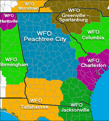
 Invite a local weather forecaster or meteorologist to discuss weather data, weather maps, and/or weather forecasting. Invite a local weather forecaster or meteorologist to discuss weather data, weather maps, and/or weather forecasting.- https://www.weather.gov/ffc/contact (WFO Peachtree City/Atlanta)
- https://www.weather.gov/tae/tae_info (WFO Tallahasee, FL)
- https://www.weather.gov/jax/staff (WFO Jacksonville, FL)
- https://www.weather.gov/cae/contact.html (WFO Columbia, S.C.)
- https://www.weather.gov/chs/office (WFO Charleston, S.C.)
- gsp.webmaster@noaa.gov (WFO Greenville-Spartanburg, S.C.)
- Please note which NWS office services your county. You can also invite TV/Radio/media meteorologists. See list above.
 Use the seasonal weather charts (temperature highs and lows; precipitation, etc.) to draw conclusions about weather patterns and seasonal changes in your region of Georgia compared to weather patterns and seasons in other parts of Georgia and other parts of the United States. Relate your conclusions about weather patterns and seasonal changes to the climate of your area. Explain the difference between weather and climate. Use the seasonal weather charts (temperature highs and lows; precipitation, etc.) to draw conclusions about weather patterns and seasonal changes in your region of Georgia compared to weather patterns and seasons in other parts of Georgia and other parts of the United States. Relate your conclusions about weather patterns and seasonal changes to the climate of your area. Explain the difference between weather and climate.- http://www.cpc.ncep.noaa.gov/
- https://weather.gov/ffc/outlooks
- https://ww2010.atmos.uiuc.edu/(Gh)/guides/crclm/act/home.rxml
|

 Send us your suggestions or other links/resources.


![[ hydro cycle ]](/images/ffc/watercycle_sm.jpg)
![[ cloud chart ]](/images/ffc/cloudchart.jpg)


