Showers, along with a few strong to severe thunderstorms, are expected from the Great Lakes, New England and southward into the Ohio and Tennessee Valleys. In the wake of this system, a stronger storm is expected to track from the Pacific Northwest, Plains and through the Eastern U.S. this weekend. Strong winds, showers and a larger drop in temperatures are expected this weekend into Monday. Read More >
A significant tornado outbreak occurred on December 26, 2015, across portions of North and Central Texas. This significant tornado outbreak produced a total of 12 confirmed tornadoes. In all, 8 counties in North and Central Texas were impacted by tornadoes. 13 individuals were killed as a result of their injuries associated with tornadoes with numerous individuals injured. More than half of these individuals were killed at the Interstate 30 and Highway 190 (President George Bush Turnpike) junction in eastern Dallas County.
| Quick Facts |
The Environment |
Satellite Presentation |
Radar Presentation |
NWS Fort Worth Products |
Confirmed Tornadoes |
North & Central Texas December Tornado Climatology |
The December 26, 2015, outbreak was noteworthy on several accounts. Below are just a few interesting tidbits. Note: The N/C TX Tornado Climatology dates back to 1950.
Click here to return to the top of the page
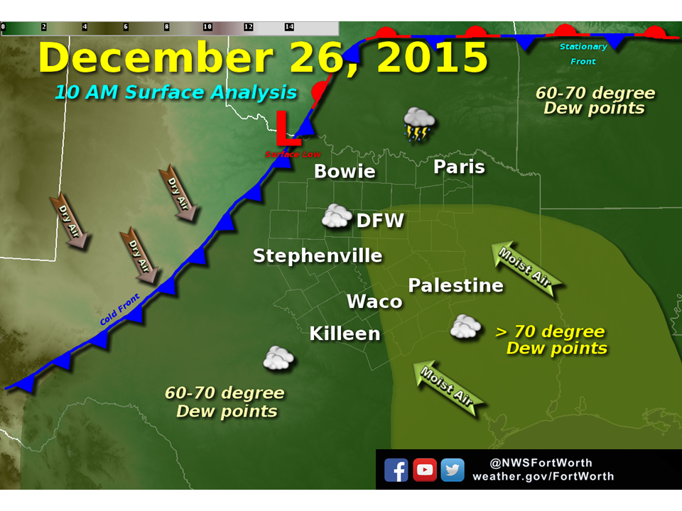
The overall synoptic environment on December 26, 2015, was governed by large scale ascent courtesy of a potent upper level trough located across the four corners region as a 100 knot upper level jet stream nudged eastward. This type of upper air pattern was observed during the Central TX tornado outbreak of December 29, 2006, as well as the December 14, 1971. The strong upper level jet allowed for a very intense surface trough to develop across portions of the central plains. Coincidentally, an extensive and sharp cold front extended from the central plains back southward through the southern plains (including Oklahoma and North Texas).
The strong surface cyclone that develops to the northwest of North and Central TX allowed low level moisture to stream northward into the area as seen in the series of analyzed surface charts. Despite the widespread cloud cover, which can be observed in the satellite presentation section below, instability and deep vertical wind shear were sufficient for severe weather. The deepening surface low resulted in 60 to even above 70 degree Dew points surging northward into the region.
| Southern Plains Surface Analysis |
 1000 CST Regional Surface Analysis |
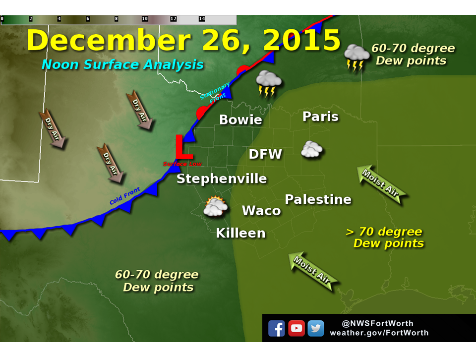 Noontime Regional Surface Analysis |
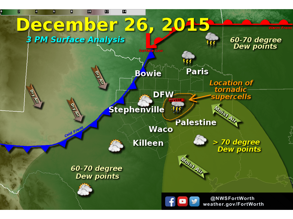 1500 CST Regional Surface Analysis |
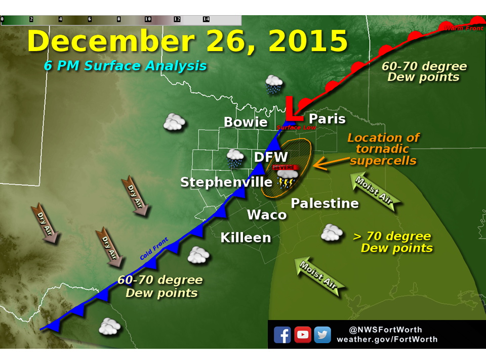 1800 CST Regional Surface Analysis |
Forecasters at both the Storm Prediction Center (SPC) and at NWS Fort Worth had continued to communicate the message of severe weather across North and Central Texas during the morning and early afternoon hours on December 26, 2015. The figures below show the progression of the SPC's Day 1 Convective outlook. Much of the region was already beneath an "enhanced risk" for severe weather with the main hazards being large hail, damaging winds and tornadoes at the 1300 UTC (700 CST) Day 1 convective outlook. As new observational data and information from hi-resolution model guidance became more readily available, the risk for severe weather continued to be messaged. Specifically, the SPC continued the "enhanced" risk for severe weather across all of North and Central at the 1600 UTC (1000 CST) Day 1 convective outlook. This "enhanced risk" of severe weather was maintained at the afternoon update (2000 UTC or 1400 CST) as well.
| Storm Prediction Center Day 1 Convective Outlooks |
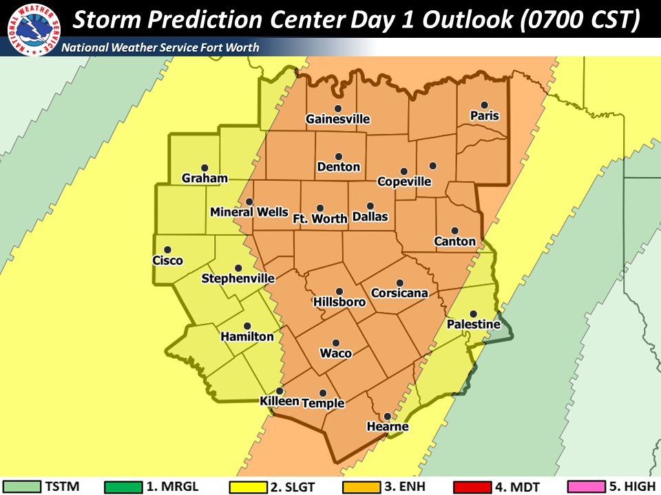 1300 UTC (0700 CST) SPC Day 1 Convective Outlook |
 1600 UTC (1000 CST) SPC Day 1 Convective Outlook |
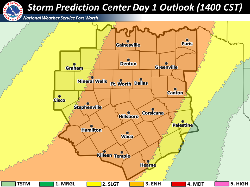 2000 UTC (1400 CST) SPC Day 1 Convective Outlook |
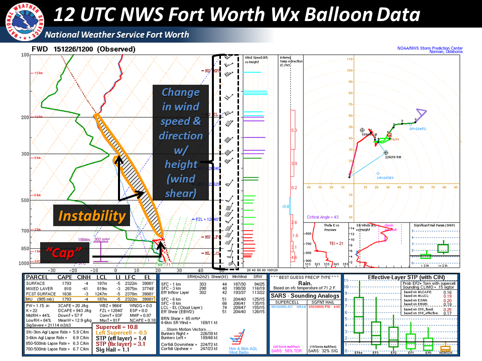
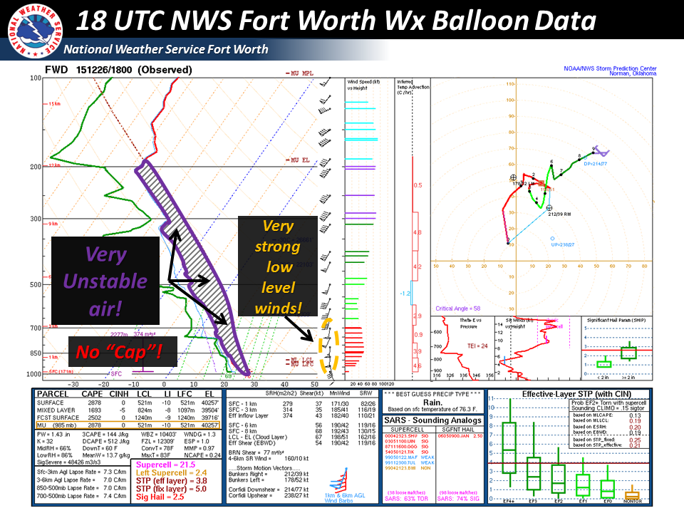
As the cold front neared North and Central TX and large scale ascent continued, the cap or layer of warm air aloft eroded as evidenced in a comparison between the 12 UTC (0600 CST) weather balloon data and the special 18 UTC (1200 CST) weather balloon data that was sampled over North Texas. Below are the annotated versions of the upper air data collected by weather balloons launched at NWS Fort Worth. Select here for the unannotated 12 UTC weather balloon data and here for the unannotated special 18 UTC weather balloon data.
| NWS Fort Worth Observed Upper Air Data |
 1200 UTC (0600 CST) on 12/26/2015 Annotated Upper Air Weather Balloon Data |
 1800 UTC (Noon) on 12/26/2015 Annotated Upper Air Weather Balloon Data |
The importance of the cap or lid of warmer air aloft, is that it oftentimes will limit the widespread nature of upward vertical motion necessary for convective growth. In some instances, if the cap or lid of warmer air aloft is large or warm enough, thunderstorms may not form at all. Regardless of the cap, the environment was very moist and unstable by late December standards. Instability values were more than 3 times the norm. The noontime (18 UTC) weather balloon data revealed that not only was the cap nearly gone, the amount of instability had increased through the afternoon hours. The noontime weather balloon data also sampled an environment with increasing low level wind speeds that helped to further transport warm and moist air towards North and Central TX. The increasing low level winds (and ultimately low level wind shear) also favored an environment conducive for all facets of severe weather. With the potential for severe weather becoming more and more imminent, the SPC and NWS Fort Worth coordinated Tornado Watch Number 569 that included all of North and Central TX.
Click here to return to the top of the page
Satellite imagery is courtesy of the Aviation Weather Center and the National Center for Atmospheric Research. Visible imagery below is valid between 1430 UTC (0830 CST) through 2315 UTC (1715 CST). Infrared (IR) imagery is valid from 1215 UTC (0615 CST) through 0630 UTC (0030 CST December 27, 2015). As seen in both the visible and IR satellite imagery, a majority of the day was actually dominated by partly to mostly cloudy skies. Towards the end of the visible and IR imagery, one should notice that the overall cloud field becomes slightly thinner, suggesting that a few areas saw some sunshine. It is likely that pockets of higher instability were present across North and Central TX and may have played a role in the initial development of showers and thunderstorms.
| Visible & Infrared Satellite Imagery |
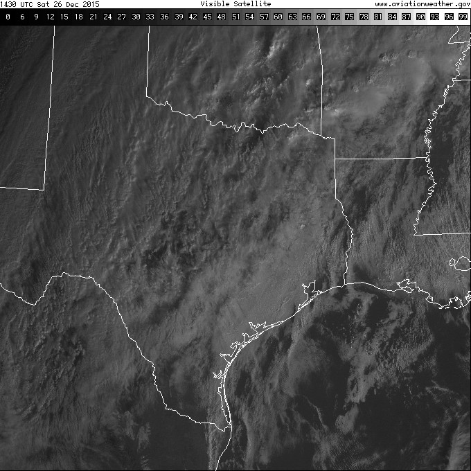 Visible Satellite Imagery |
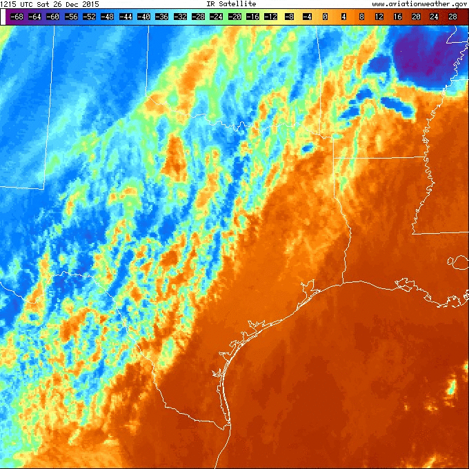 Infrared Satellite Imagery |
Click here to return to the top of the page
Animated gifs from radar imagery across North and Central TX during the afternoon and evening hours of December 26, 2015, can be seen below. In general, the three main radars used to make warning decisions on the afternoon and into the evening were the Weather Surveillance Radar 1988 Doppler (WSR-88D) radar located at the Fort Worth Spinks airport (KFWS), the Dallas Love Field Terminal Doppler Weather Radar (TDAL TDWR) and the WSR-88D located near Granger, TX (KGRK).
| NWS and FAA Weather Radar Imagery |
 Fort Worth Spinks WSR-88D Radar Imagery |
 Fort Hood/Central TX WSR-88D Radar Imagery |
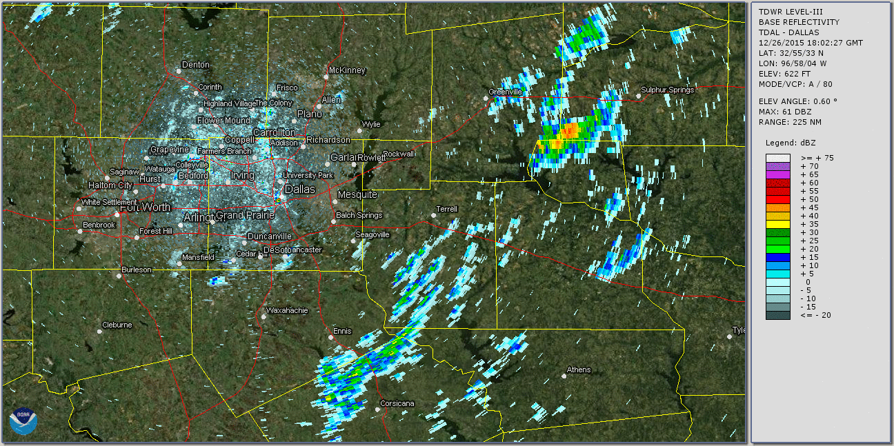 Dallas Love Field TDWR Radar Imagery |
Click here to return to the top of the page
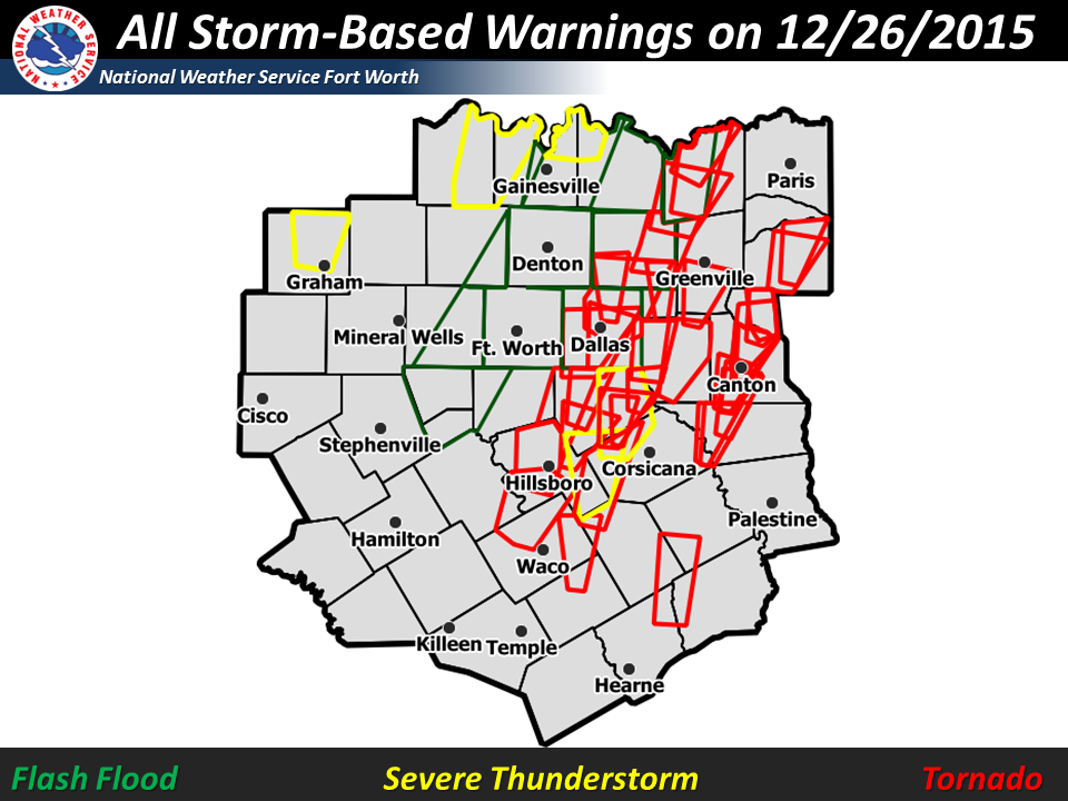
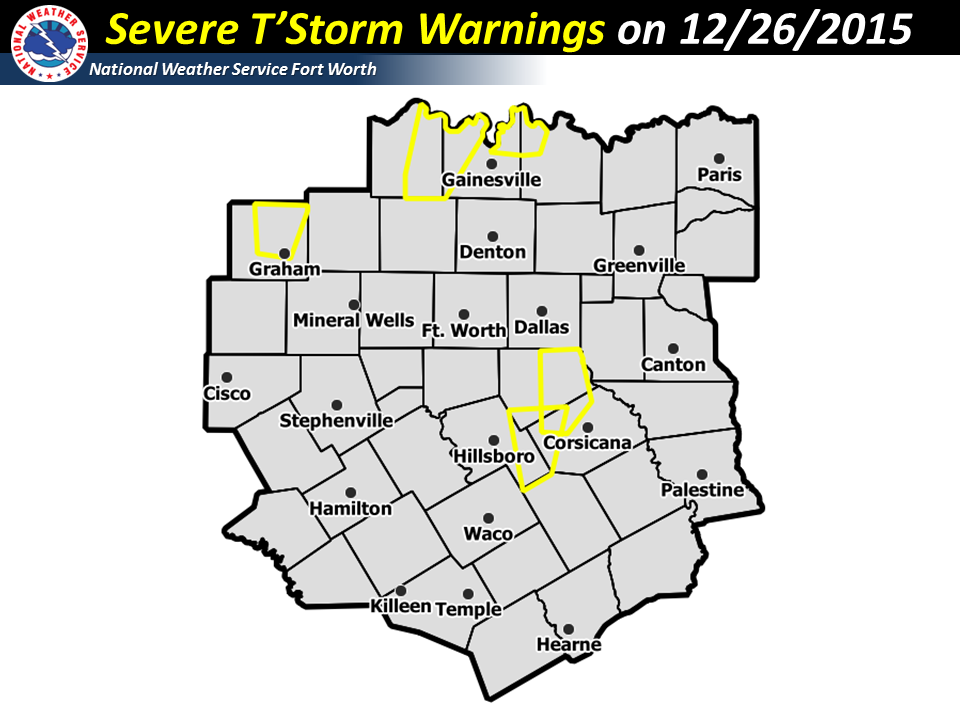
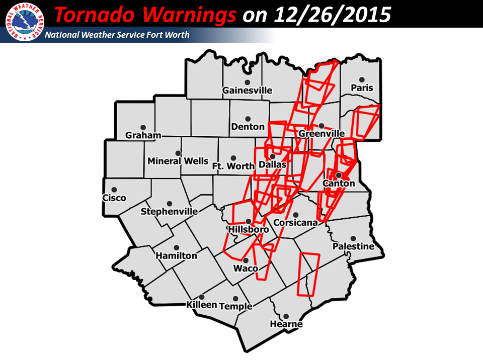
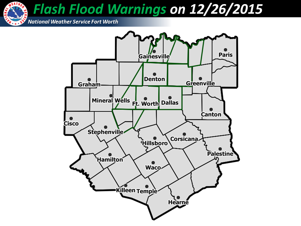
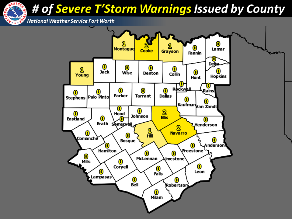
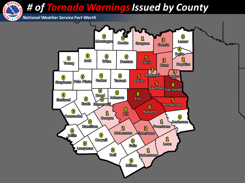
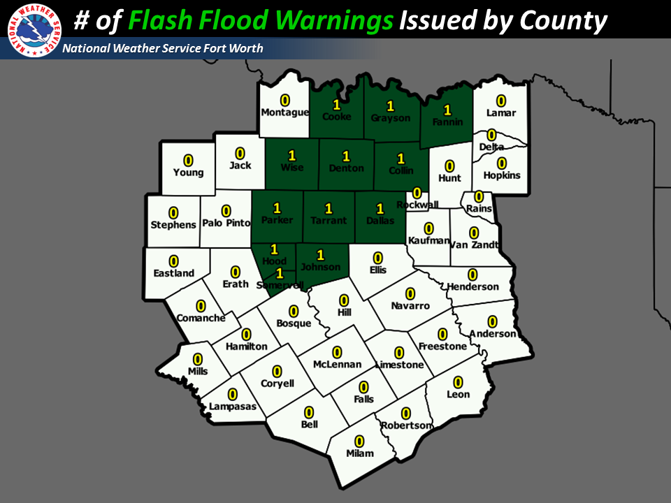
NWS Fort Worth was very busy during the severe weather outbreak on December 26, 2015. The FIRST warning (Tornado Warning for portions of Limestone, Robertson, Leon and Freestone counties) was issued at 1343 CST that afternoon. The LAST warning (Flash Flood Warning for Cooke and Grayson counties) expired at 2330 CST that evening. Below are a couple of quick stats about the products issued by NWS Fort Worth.
| NWS Fort Worth Storm Based Warnings |
| NWS Fort Worth Text Product Archive |
| Local Storm Reports (LSR) | Final Public Information Statement (PNS) |
Select one of the above products in the table to view products issued by NWS Fort Worth before, during or after the December 26, 2015, tornado outbreak (opens in new window)
| NWS Fort Worth Multimedia & Social Media Archive |
| NWS Fort Worth Graphicasts | @NWSFortWorth Tweets | YouTube Weather Briefings |
| EM Briefing #1 Slides and EM Briefing #2 Slides | EM Head's Up Emails | NWS Fort Worth NWSChat Log |
Select one of the items above to view Multimedia or Social Media post by NWS Fort Worth before or during the December 26, 2015, tornado outbreak (opens in new window)
Click here to return to the top of the page
For the entire event, 12 tornadoes were confirmed, mainly across North Texas. 3 of the 12 tornadoes were rated EF-2 or greater with the most intense, damage occurring with the Sunnyvale-Garland-Rowlett tornado. Unfortunately 13 fatalities were reported.
*Click on the map below to view some of the pictures of the damage taken by the NWS Survey Team. Open map in a new window
The thumbnails below show tornado tracks/damage swaths or points associated with each of the 12 confirmed tornadoes across North Texas on December 26, 2015.
| NWS Fort Worth Storm Survey Results* |
Sunnyvale-Garland-Rowlett (EF-4)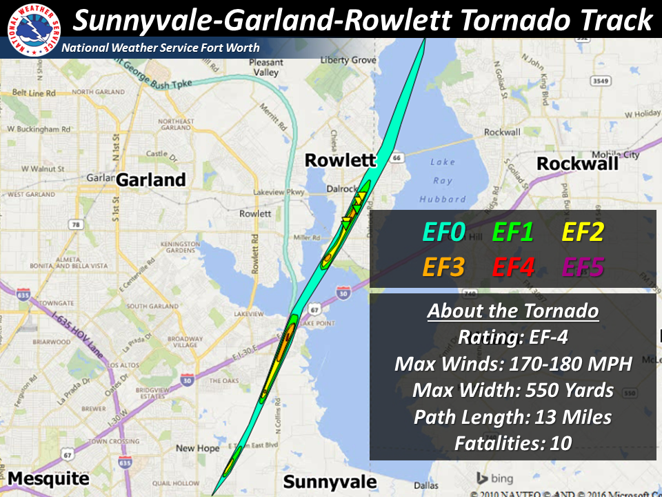 |
Midlothian-Ovilla-Glenn Heights (EF-3)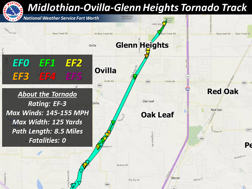 |
Copeville (EF-2)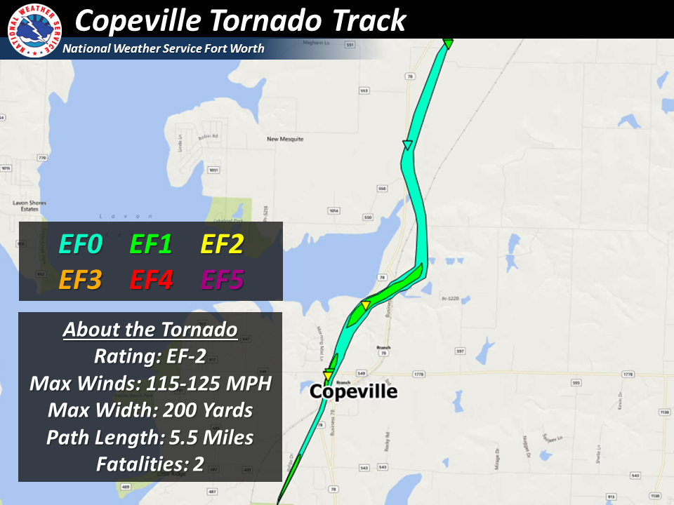 |
Farmersville (EF-1)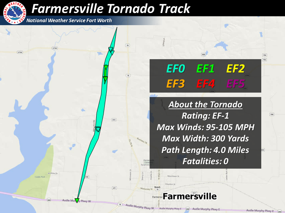 |
Blue Ridge (EF-1)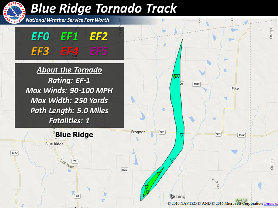 |
Ennis/Rosser (EF-0)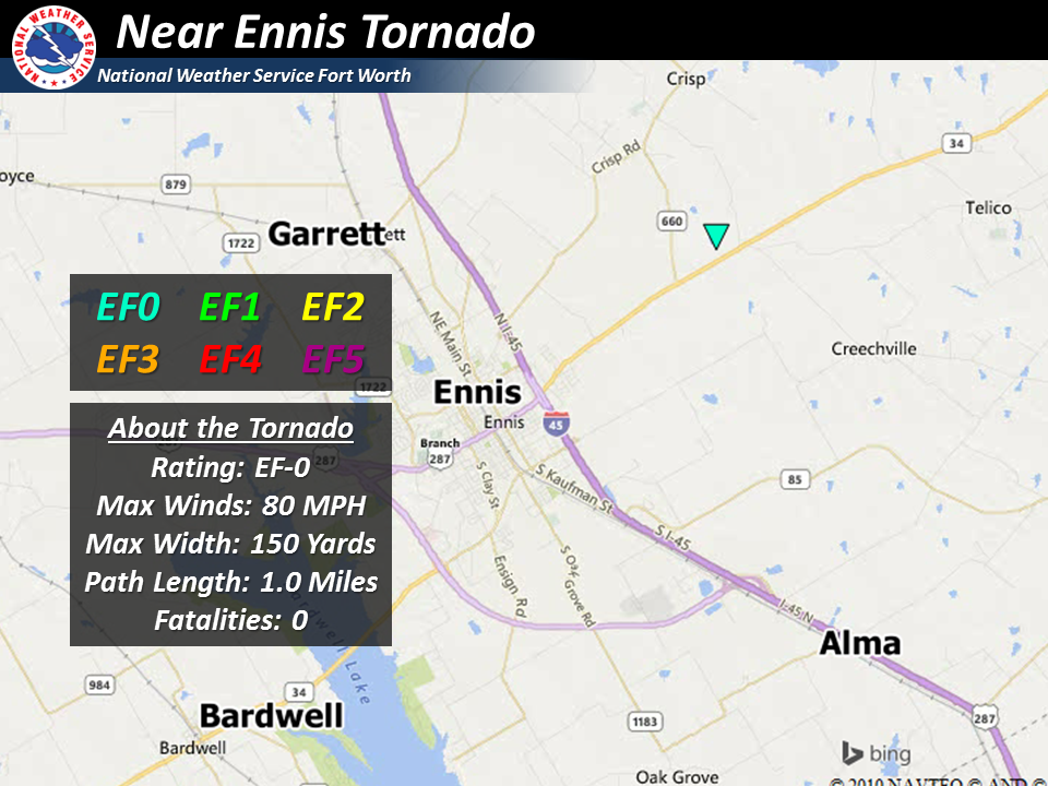 |
Maypearl (EF-0)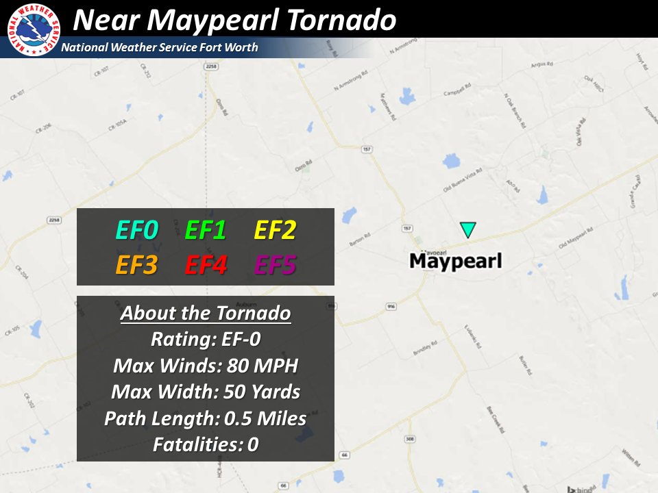 |
Eustace (EF-0)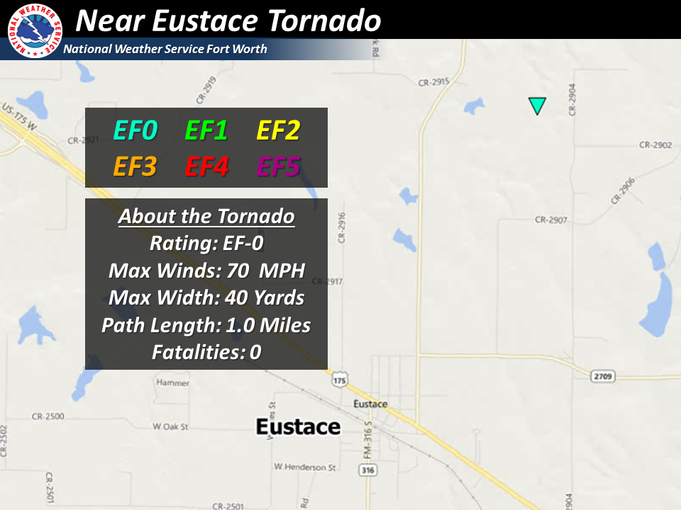 |
Hillsboro (EF-0)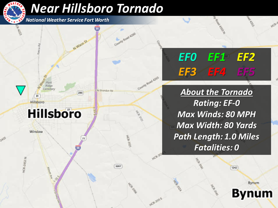 |
Hubbard (EF-0)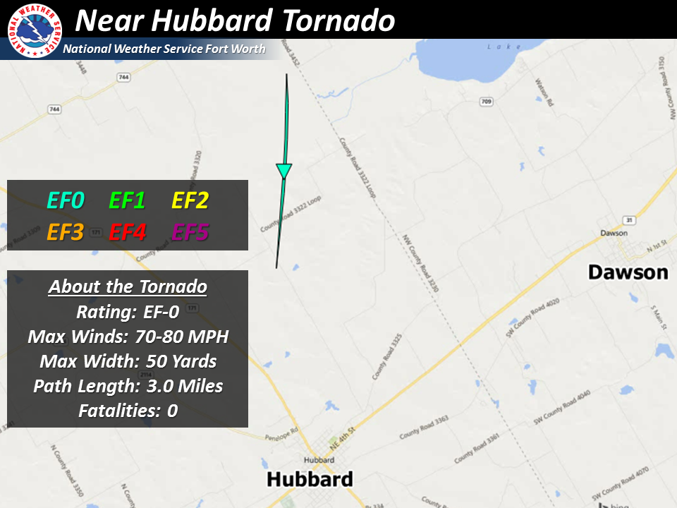 |
Sulphur Springs (EF-0)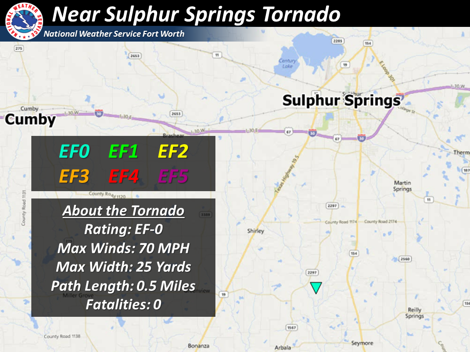 |
Emory (EF-0)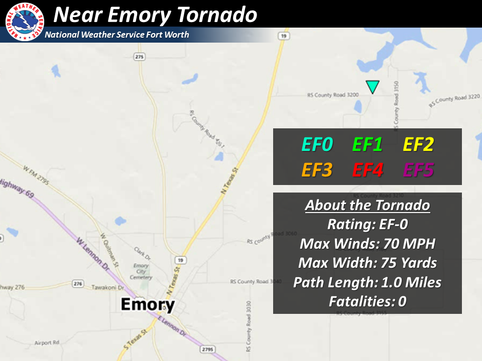 |
Select any of the thumbnails to see a larger image of the damage track/point (opens in new window) for confirmed tornadoes on December 26, 2015
Special thanks to meteorologists from the NWS Southern Region Headquarters and meteorologists from NWS Houston/Galveston who assisted the NWS Fort Worth staff in storm surveys across North and Central TX after the December 26, 2015, outbreak.
.
Click here to return to the top of the page
While December is statistically not the most active period for severe weather across North and Central TX as seen in a monthly distribution chart, there have been several noteworthy tornado events that have occurred. Days in which more than 15 tornadoes were confirmed in 24 hours across North and Central TX have occurred on December 14, 1971 (total of 21 confirmed tornadoes, and again on December 29, 2006 (total of 22 confirmed tornadoes). Below are maps of tornado tracks/points during those events. A preliminary map of tornado tracks/ points that occurred on December 26, 2015, is provided in the third panel for comparison.
| Noteworthy North and Central TX Tornado Outbreaks |
December 14, 1971 Tornado Outbreak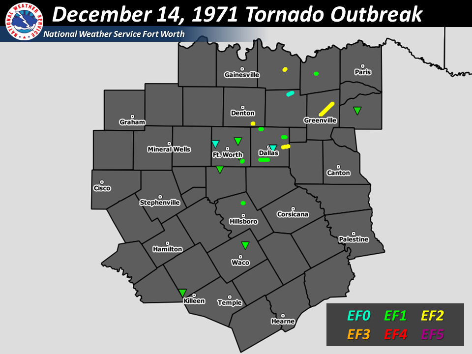 |
December 29, 2006 Tornado Outbreak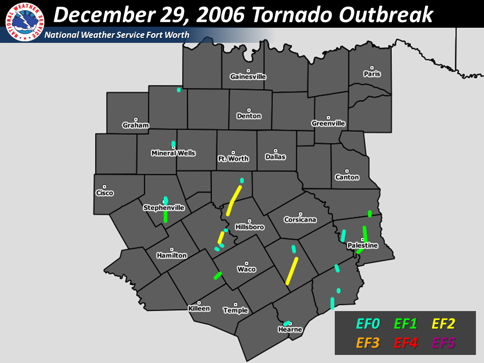 |
December 26, 2015 Tornado Outbreak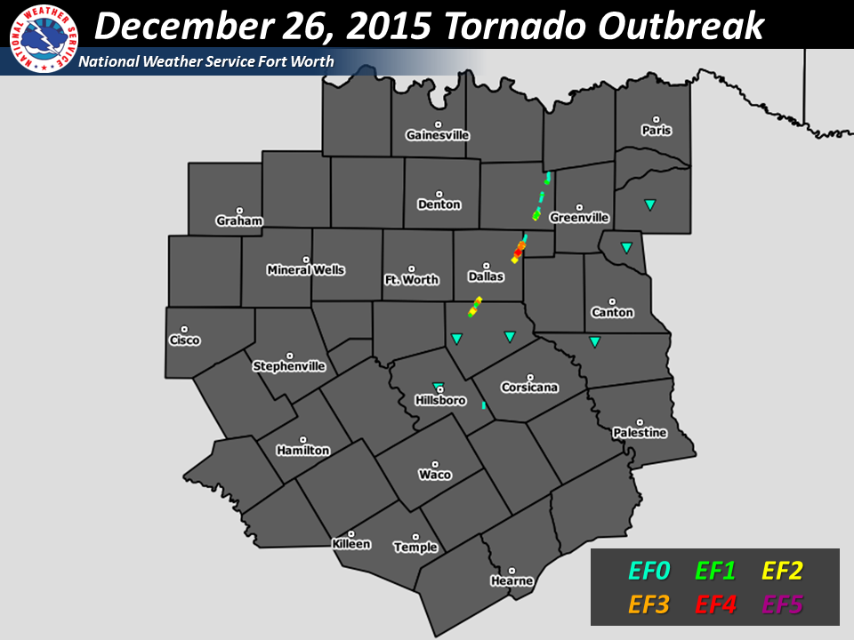 |
Select any of the thumbnails to see a larger image of confirmed tornado points/tracks during notable December Tornado Outbreaks across North and Central TX.
N/C TX December Tornadoes (sans 12/26/2015)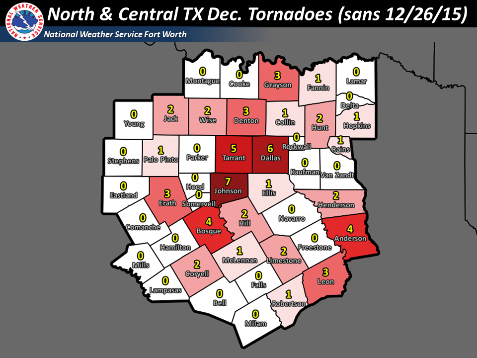 |
Confirmed Tornadoes by County on 12/26/2015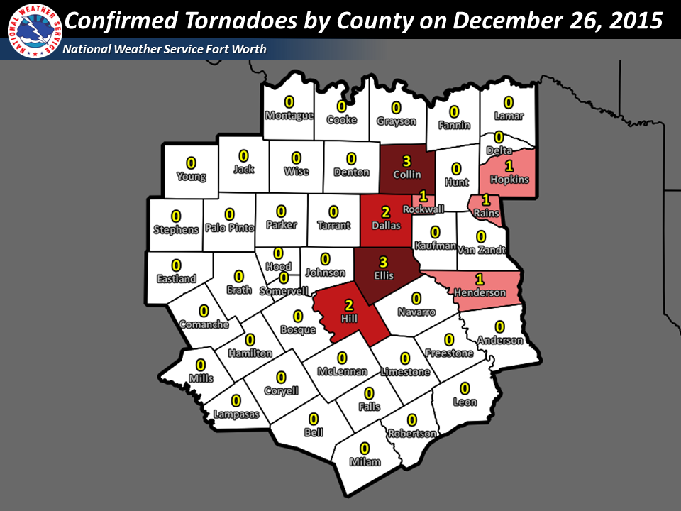 |
ALL N/C TX December Tornadoes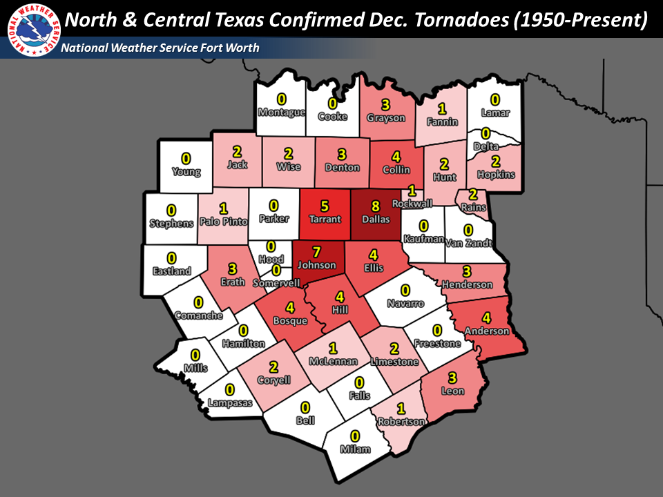 |
Select any of the thumbnails to see a larger image of confirmed tornadoes during the month of December across North and Central TX.
| December Tabular Tornado Fatality Data for North and Central Texas since 1950 |
| Date | County | City | Rating (F/EF Scale) | Fatalities |
| 12/02/1999 | Wise | Chico | 1 | 2 |
| 12/29/2006 | Limestone | Groesbeck | 2 | 1 |
| 12/26/2015 | Dallas | Garland | 4 | 9 |
| 12/26/2015 | Dallas | Rowlett | 4 | 1 |
| 12/26/2015 | Collin | Copeville | 2 | 2 |
| 12/26/2015 | Collin | Farmersville | 1 | 1 |
For a complete listing of December tornadoes across North and Central Texas since 1950, click here.
| Tornado Data for select counties ✠across North and Central Texas since 1880 (opens csv file) |
| Collin✠| Dallas✠| Ellis✠| Hill✠|
| Henderson✠| Hopkins✠| Rains✠| Rockwall✠|
Click here to return to the top of the page