
A storm and trailing cold front will continue to slowly move through the Gulf Coast and Southeast U.S. through this weekend with widespread rain showers and isolated thunderstorms. A fast-moving clipper storm may bring several inches of snow to the north-central Plains, Midwest, eastern Great Lakes, and Northeast regions this weekend. Read More >
Overview/Narrative:
(BE SURE TO CLICK THE VARIOUS TABS BELOW FOR A VARIETY OF OCTOBER 2017 CLIMATE INFORMATION!)
|
Recap of October 2017 Weather for the 30-county NWS Hastings Coverage Area:
|
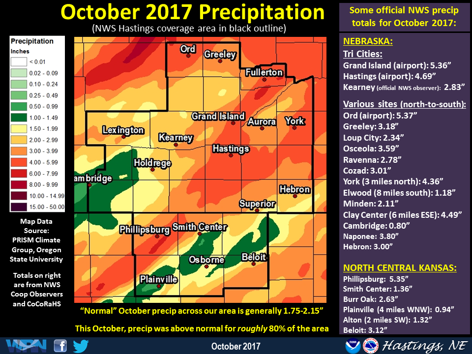 This graphic features a precipitation map for October 2017, along with a partial listing of official NWS/CoCoRaHS totals (Click image to enlarge) |
Grand Island & Hastings Details (Including 12-Month History):
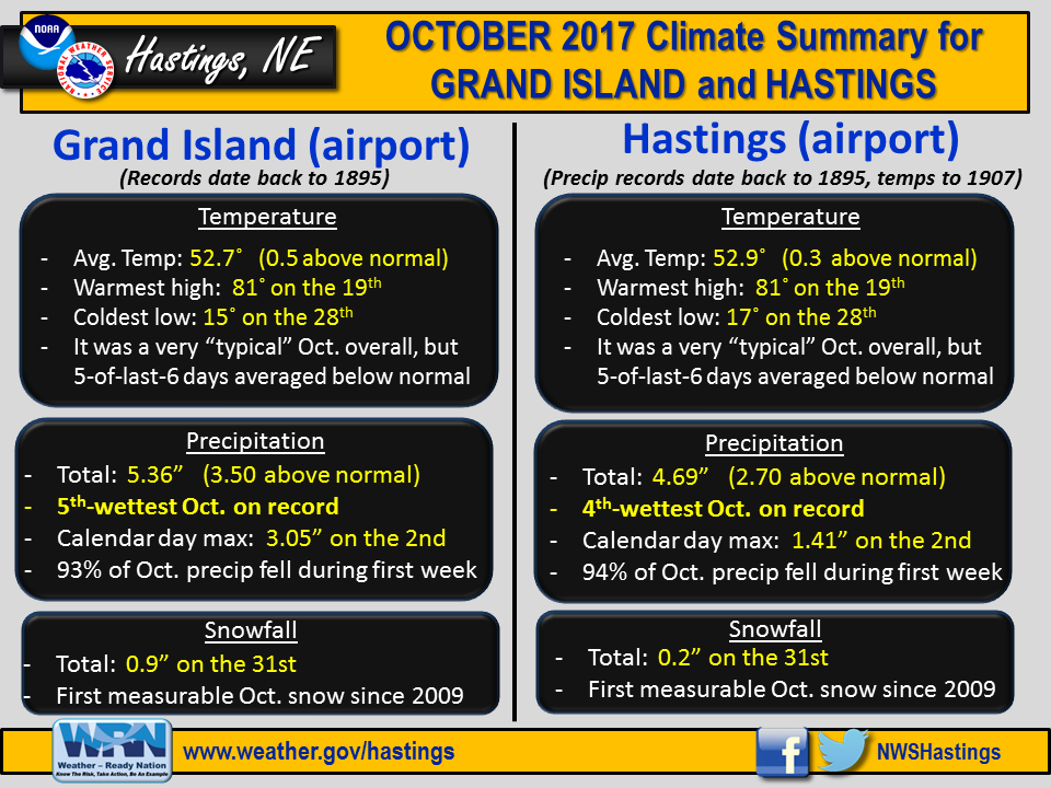 |
| Detailed Oct. 2017 info for Grand Island/Hastings (Click to enlarge) |
 |
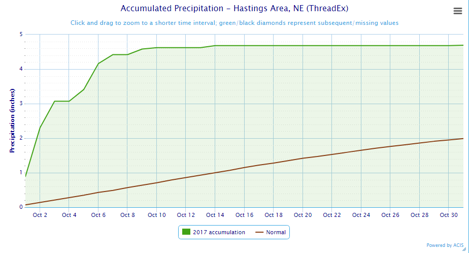 |
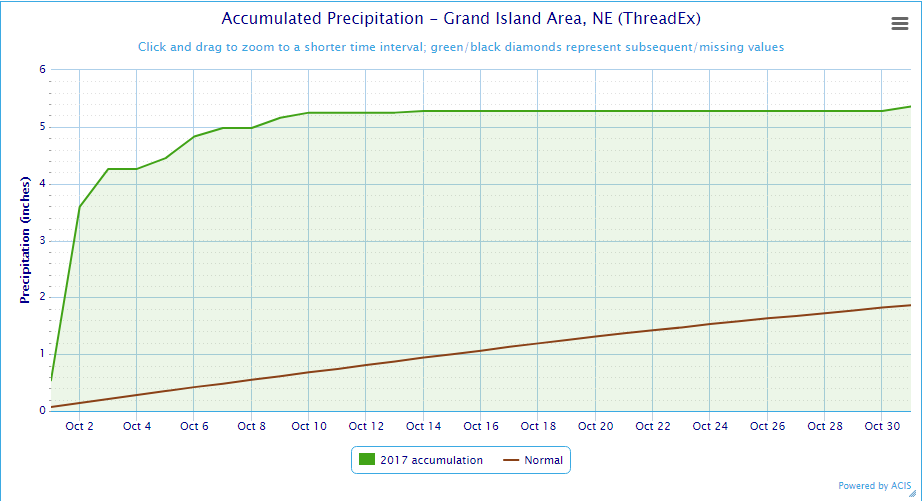
| Grand Island Precipitation Summary: The green line indicates cumulative observed precipitation for October 2017.The brown line indicates "normal" October precipitation based on 30-year data from 1981-2010. (click to enlarge) | Hastings Precipitation Summary: The green line indicates cumulative observed precipitation for October 2017. The brown line indicates "normal" October precipitation based on 30-year data from 1981-2010. (click to enlarge) |
| Grand Island (Regional Airport ASOS) - November 2016 - October 2017 | ||||||||||||
| Nov. | Dec. | Jan. | Feb. | Mar. | Apr. | May | June | July | Aug. | Sep. | Oct. | |
| Average High (F) | 57.3 | 37.3 | 34.6 | 50.8 | 54.4 | 63.1 | 72.7 | 87.5 | 88.9 | 81.3 | 80.5 | 65.2 |
| Average Low (F) | 32.7 | 14.5 | 17.9 | 24.8 | 30.0 | 39.2 | 49.6 | 61.2 | 66.6 | 58.9 | 55.0 | 40.2 |
| Average Temperature (F) | 45.0 | 25.9 | 26.3 | 37.8 | 42.2 | 51.1 | 60.3 | 74.4 | 77.8 | 70.1 | 67.8 | 52.7 |
| Departure From Normal | +6.9 | -0.8 | +1.2 | +8.7 | +2.8 | +0.5 | -0.9 | +3.1 | +1.6 | -3.9 | +2.7 | +0.5 |
| Precipitation (in) | 1.37 | 0.81 | 1.07 | 0.25 | 0.81 | 2.64 | 5.28 | 2.10 | 3.05 | 6.19 | 2.68 | 5.36 |
| Departure From Normal | +0.20 | +0.18 | +0.54 | -0.43 | -0.99 | +0.11 | +0.87 | -2.20 | -0.35 | +3.07 | +0.45 | +3.50 |
| Snowfall (in) | 0.4 | 1.4 | 2.4 | 3.5 | 1.2 | T | 0.3 | 0.0 | 0.0 | 0.0 | 0.0 | 0.9 |
| Departure From Normal | -2.7 | -3.7 | -4.1 | -2.8 | -4.2 | -1.5 | +0.3 | 0.0 | 0.0 | 0.0 | -0.1 | -0.1 |
| Hastings (Municipal Airport ASOS) - November 2016 - October 2017 | ||||||||||||
| Nov. | Dec. | Jan. | Feb. | Mar. | Apr. | May | June | July | Aug. | Sep. | Oct. | |
| Average High (F) | 57.4 | 37.7 | 35.7 | 51.4 | 55.4 | 63.4 | 72.8 | 86.3 | 88.9 | 81.7 | 81.2 | 64.9 |
| Average Low (F) | 34.2 | 15.6 | 19.4 | 25.8 | 31.3 | 40.7 | 49.5 | 62.1 | 67.6 | 59.8 | 55.9 | 40.8 |
| Average Temperature (F) | 45.8 | 26.6 | 27.6 | 38.6 | 43.4 | 52.1 | 61.1 | 74.2 | 78.2 | 70.7 | 68.6 | 52.9 |
| Departure From Normal (F) | +7.1 | -1.0 | +1.6 | +8.7 | +3.5 | +1.4 | -0.2 | +2.4 | +1.1 | -3.6 | +3.0 | +0.3 |
| Precipitation (in) | 1.46 | 0.61 | 0.83 | 0.27 | 1.08 | 3.24 | 6.42 | 1.79 | 4.71 | 5.10 | 2.18 | 4.69 |
| Departure From Normal (in) | +0.17 | 0.00 | +0.42 | -0.22 | -0.71 | +0.68 | +1.85 | -2.01 | +0.97 | +1.80 | -0.38 | +2.70 |
| Snowfall (in) | 0.1 | 1.0 | 3.7 | 4.3 | 1.2 | 0.2 | 0.6 | 0.0 | 0.0 | 0.0 | 0.0 | 0.2 |
| Departure From Normal (in) | -2.5 | -5.1 | -2.3 | -2.2 | -4.0 | -1.0 | +0.6 | 0.0 | 0.0 | 0.0 | -0.2 | -1.0 |
Kearney - 12 Month Climate History:
All data here is from the official NWS observer at Kearney airport, with 24-hour observations taken around 7 a.m. ** PLEASE NOTE: This official Kearney data often differs at least slightly from the unofficial data recorded by the automated airport system (KEAR) **
| Kearney Airport (Coop Observer) - November 2016 - October 2017 | ||||||||||||
| Nov. | Dec. | Jan. | Feb. | Mar. | Apr. | May | June | July | Aug. | Sep. | Oct. | |
| Average High (F) | 58.6 | 37.8 | 36.9 | 50.0 | 54.6 | 62.5 | 70.2 | 86.6 | 88.1 | 81.2 | 80.7 | 65.9 |
| Average Low (F) | 33.4 | 14.8 | 19.5 | 24.1 | 28.6 | 38.8 | 45.9 | 59.7 | 64.8 | 56.9 | 52.6 | 40.0 |
| Average Temperature (F) | 46.0 | 26.3 | 28.2 | 37.1 | 41.6 | 50.7 | 58.1 | 73.2 | 76.5 | 69.1 | 66.6 | 53.0 |
| Departure From Normal (F) | +9.0 | +0.4 | +3.6 | +9.0 | +3.9 | +2.0 | -1.4 | +3.4 | +1.8 | -3.5 | +3.1 | +2.1 |
| Precipitation (in) | 1.56 | 0.90 | 0.90 | 0.30 | 1.63 | 1.87 | 6.03 | 1.93 | 3.66 | 3.65 | 2.19 | 2.83 |
| Departure From Normal (in) | +0.54 | +0.33 | +0.41 | -0.25 | -0.16 | -0.36 | +1.85 | -2.00 | +0.38 | +0.57 | +0.12 | +0.79 |
| Snowfall (in) | 0.2 | 1.0 | 4.5 | 5.2 | 0.7 | T | 1.6 | 0.0 | 0.0 | 0.0 | 0.0 | 0.0 |
| Departure From Normal (in) | -2.9 | -2.5 | +0.1 | +0.1 | -3.9 | -1.8 | +1.6 | 0.0 | 0.0 | 0.0 | -0.2 | -0.7 |
Ord - 12 Month Climate History:
Winter precipitation totals often include NWS Cooperative Observer data due to the automated airport equipment under-measuring snowfall liquid equivalent.
| Ord (Evelyn Sharp Field ASOS) - November 2016 - October 2017 | ||||||||||||
| Nov. | Dec. | Jan. | Feb. | Mar. | Apr. | May | June | July | Aug. | Sep. | Oct. | |
| Average High (F) | 56.7 | 37.6 | 34.1 | 48.4 | 53.7 | 61.7 | 69.7 | 86.3 | 90.3 | 81.4 | 78.0 | 63.7 |
| Average Low (F) | 28.1 | 9.3 | 14.2 | 19.8 | 28.7 | 37.9 | 44.1 | 56.9 | 64.1 | 56.3 | 51.2 | 36.1 |
| Average Temperature (F) | 42.4 | 23.5 | 24.1 | 34.1 | 41.2 | 49.8 | 56.9 | 71.6 | 77.2 | 68.8 | 64.6 | 49.9 |
| Departure From Normal (F) | +6.1 | -1.4 | -0.5 | +6.3 | +3.5 | +1.0 | -2.4 | +2.4 | +2.8 | -4.2 | +1.0 | +0.3 |
| Precipitation (in) | 1.26 | 0.41 | 1.15 | 0.79 | 1.83 | 4.25 | 3.10 | 0.59 | 2.53 | 5.93 | 2.89 | 5.37 |
| Departure From Normal (in) | +0.19 | -0.18 | +0.78 | +0.35 | +0.38 | +1.66 | -0.71 | -3.53 | -0.44 | +2.77 | +0.45 | +3.44 |
| Snowfall (in) | 3.0 | 2.7 | 11.9 | 10.4 | 1.9 | 1.0 | 6.0 | 0.0 | 0.0 | 0.0 | 0.0 | 0.0 |
| Departure From Normal (in) | -2.3 | -4.7 | +5.1 | +4.4 | -4.0 | -1.5 | +6.0 | 0.0 | 0.0 | 0.0 | 0.0 | -1.1 |
Smith Center, KS - 12 Month Climate History:
All data is from the official NWS observer, with 24-hour observations taken around 7 a.m. As a result, data may vary slightly from true "Calendar Day" totals.
| Smith Center KS (NWS Coop Observer) - Nov. 2016 - Oct. 2017 | ||||||||||||
| Nov. | Dec. | Jan. | Feb. | Mar. | Apr. | May | June | July | Aug. | Sep. | Oct. | |
| Average High (F) | 61.0 | 38.7 | 39.0 | 53.4 | 58.5 | 65.4 | 73.9 | 89.8 | 95.2 | 86.4 | 85.6 | 70.5 |
| Average Low (F) | 32.9 | 14.2 | 18.5 | 24.2 | 30.2 | 40.0 | 46.8 | 60.9 | 66.7 | 59.9 | 56.0 | 40.1 |
| Average Temperature (F) | 47.0 | 26.5 | 28.7 | 38.8 | 44.4 | 52.7 | 60.4 | 75.4 | 80.9 | 73.1 | 70.8 | 55.7 |
| Departure From Normal (F) | +6.6 | -2.3 | +1.0 | +6.8 | +2.8 | +0.2 | -3.3 | +1.4 | +1.2 | -4.1 | +2.6 | +0.9 |
| Precipitation (in) | 0.99 | 0.56 | 1.46 | 0.27 | 1.26 | 3.32 | 7.03 | 1.31 | 3.26 | 2.05 | 2.67 | 1.36 |
| Departure From Normal (in) | -0.23 | -0.10 | +0.97 | -0.31 | -0.61 | +1.05 | +3.11 | -2.30 | -0.61 | -1.25 | +0.63 | -0.52 |
| Snowfall (in) | 0.0 | 3.1 | 1.1 | 1.8 | 0.2 | 0.0 | 0.0 | 0.0 | 0.0 | 0.0 | 0.0 | 0.0 |
| Departure From Normal (in) | -1.8 | -0.1 | -2.6 | -2.3 | -2.4 | -0.6 | 0.0 | 0.0 | 0.0 | 0.0 | -0.2 | -0.4 |
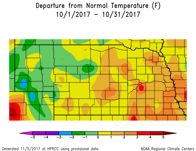
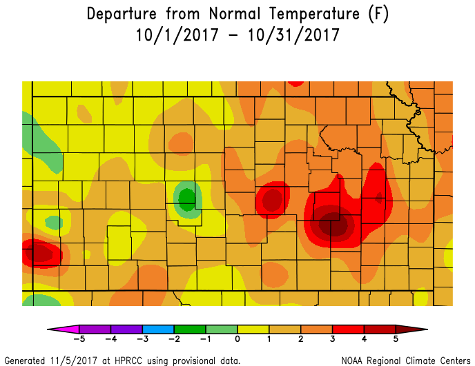
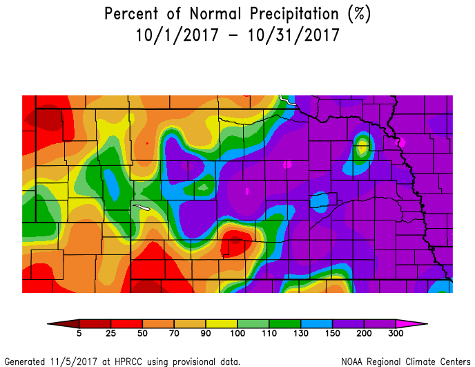
Temperature & Precipitation Departure From Normal Maps:
These images depict October 2017 monthly temperature departure from normal & precipitation percent-of-normal for both Nebraska & Kansas. Images are courtesy of the High Plains Regional Climate Center (HPRCC). Please note: These maps occasionally contain "bullseyes" of errant data. For precipitation, you can also generate departure from normal/percent-of-normal maps using the NWS AHPS page
 |
 |
 |
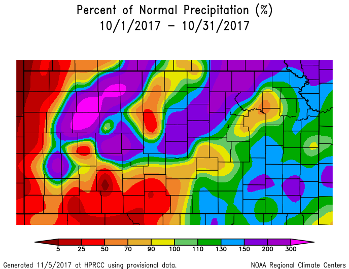 |
| Departure from Normal Temperature - NE (left) & KS (right) | Percent of Normal Precipitation - NE (left) & KS (right) | ||
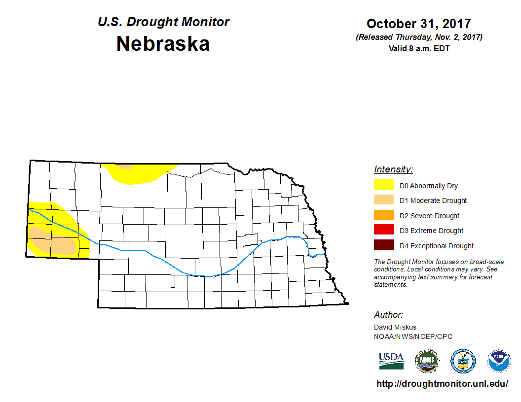
Drought:
The following drought images, current as of October 31, 2017, are courtesy of the U.S. Drought Monitor
Brief summary of changes during October for the NWS Hastings coverage area:
Given that above normal precipitation was noted across roughly 80% of the NWS Hastings coverage area, it followed suit that official drought categories either remained non-existent (most of the area) or saw one-category improvement (parts of north central Kansas).
More specifically, literally the entire Nebraska portion of the local area (24 counties) remained void of all drought categories whatsoever at month's end. Farther south in our 6 local north central Kansas counties, improvement was noted for the second consecutive month. Namely, the area of Moderate Drought (D1) that had encompassed parts of southern Osborne and far southwestern Mitchell counties was improved to Abnormally Dry (D0), while drought categories became or remained non-existent elsewhere.
 |
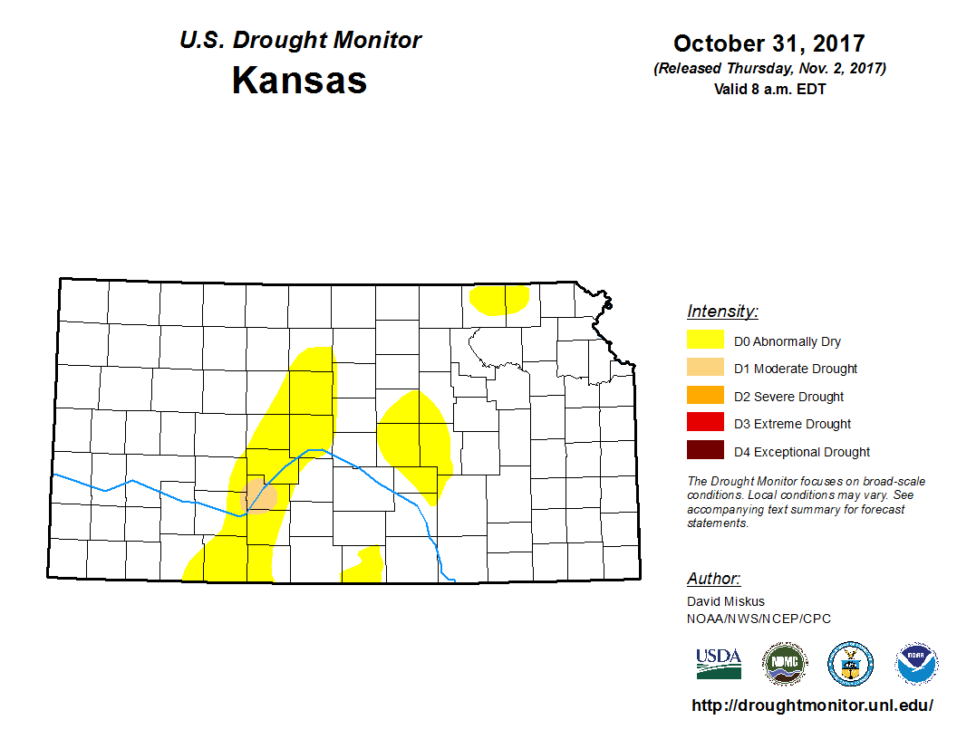 |
| Drought Monitor for Nebraska (left) & Kansas (right). Valid as of October 31, 2017 (click to enlarge) | |
Monthly Extremes for the NWS Hastings Coverage Area:
...A FEW OF THE WARMEST HIGH TEMPERATURES DURING OCTOBER 2017...
(all data from NWS cooperative observers or automated airport sites, with the date in parentheses)
88 degrees...4WNW Plainville KS (17th)
87 degrees...Webster Dam KS (5th)
85 degrees...2SW Alton KS (5th) - Beloit KS (2nd)
...A FEW OF THE COLDEST LOW TEMPERATURES DURING OCTOBER 2017...
(all data from NWS cooperative observers or automated airport sites, with the date in parentheses)
8 degrees...Ord airport (28th)
9 degrees...Greeley (28th)
11 degrees...2SW Alton KS (28th) - Ravenna (28th)
...A FEW OF THE HIGHEST MONTHLY PRECIPITATION TOTALS DURING OCTOBER 2017...
(all data from NWS cooperative observers or CoCoRaHS/NeRAIN observers unless indicated)
7.41"...6E Phillipsburg KS (5.35" in Phillipsburg per NWS observer)
5.37"...Ord airport (5.30" in Ord per NWS observer)
5.36"...Grand Island airport
4.80"...3NE Shelby
4.69"...4SW Blue Hill
...A FEW OF THE LOWEST MONTHLY PRECIPITATION TOTALS DURING OCTOBER 2017...
(all data from NWS cooperative observers or CoCoRaHS/NeRAIN observers unless indicated)
0.80"...Cambridge
0.94"...4WNW Plainville KS
1.05"..Cawker City KS
1.07"...6NNW Oxford
1.18"...8S Elwood
...A FEW OF THE HIGHEST MONTHLY SNOWFALL TOTALS DURING OCTOBER 2017...
(all data from NWS cooperative observers)
0.9"...Grand Island airport
0.2"...Hastings (NWS office/airport)
PLEASE NOTE: Although much of the area received snow on the 31st, the vast majority of NWS cooperative observers report for a 24-hour period ending around 7 AM. As a result, the snow for these stations will officially be included with NOVEMBER 1ST data.
 |
Media use of NWS Web News Stories is encouraged! Please acknowledge the NWS as the source of any news information accessed from this site. |
|

