|
On the afternoon of March 30th, a 970 mb area of low pressure over southeastern Nebraska/northeastern Kansas was in place with an attendant cold front starting to extend southwest of this low to New Mexico and northwestern Texas. This front was very slow moving, and was tapping into very moist air advecting ahead of it into the Southeast from the Gulf of Mexico. Very dry air was still in place over the Tennessee Valley, courtesy of an area of high pressure centered over extreme eastern North Carolina (dewpoints mainly in the 40s). However overnight, moist southerly low level winds increased significantly across the Tennessee Valley, as an upper level disturbance approached the Tennessee Valley region. This disturbance moved across Mississippi and into the Tennessee Valley toward daybreak on March 31st. Due to the increasingly moist, but still relatively stable airmass in place, and despite strong wind energy accompanying this disturbance, the primary result of this disturbance was steady moderate to heavy rainfall which produced between 1.0 and 2.5 inches of rainfall mainly along and west of I-65 with less than 0.5 inches further east.
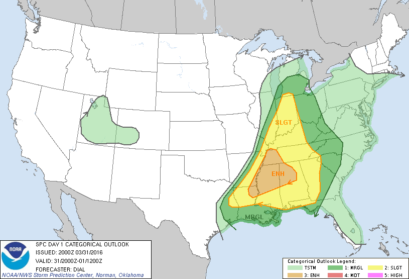
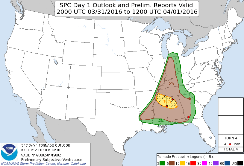
By the early to mid afternoon hours on Thursday, the cold front previously over northwest Texas had pushed east into eastern Arkansas. An extremely moist airmass was in place ahead of this front over Mississippi and Louisiana, with dewpoints in the upper 60s to lower 70s. Severe storms (some supercells with rotation) developed over Louisiana and Mississippi during this time. However, over the Tennessee Valley an outflow boundary had setup from earlier rainfall that occurred with the disturbance overnight on the 30th, until around noon on the 31st. This boundary stretched from central Alabama northwest into Franklin and Colbert counties in northwestern Alabama. Despite some clearing and abundant sunshine for a couple hours between 11 am and 4 pm, subsidence behind this boundary over northern Alabama helped to keep convection from initiating in the early afternoon hours despite increasing instability. However, by 4:28 pm the first severe thunderstorm pushed into Colbert and Lauderdale counties in northwestern Alabama. The boundary draped over central/northwestern AL continued to move north during the late afternoon and early evening hours, so that it was draped just over the TN/AL border north of Lauderdale and Limestone counties by the mid-afternoon hours. During this time frame, multiple supercell thunderstorms (some severe) continued to develop near this boundary and move from west to east into Lincoln, Moore, and Franklin counties in Tennessee. Several of these supercells prompted tornado warnings for northern Lauderdale and Limestone counties in Alabama, as well as Lincoln, Moore, and Franklin counties in Tennessee through 10 PM. In addition across Southern Middle Tennessee, these training storms (moving over same locations) produced an additional 2 to 3 inches of rainfall, which produced widespread flash flooding/river flooding in those areas. Further south an additional 1 to 2 inches of rainfall occurred. Other strong to severe thunderstorms developed around 6 PM further south across the remainder of northern Alabama. This second wave of showers, and strong to severe thunderstorms produced at least one tornado, quarter size hail, and some damaging winds. Luckily, the atmosphere was too stable and very little lift was actually associated with the weakening cold front, as it pushed across northern Alabama and Southern Middle Tennessee after midnight. So little additional rainfall fell after midnight. Finally early Friday morning on the April 1st, the weakening cold front moved across southern Alabama and Georgia ending any additional chances of rain.
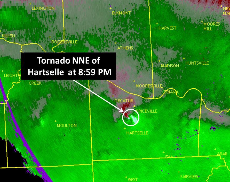
Forty-eight hour rainfall totals in portions of Southern Middle Tennessee were impressive and ranged from 3 to 6 inches. Below is a map of the one confirmed tornado that occurred during this event.
|


 Local Radar
 Weather Map
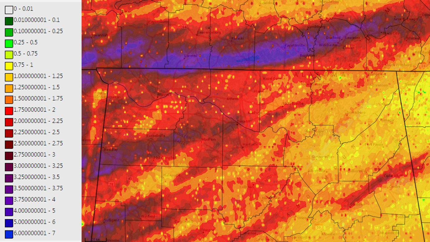