NWS Huntsville Storm Surveys
|
||||
|---|---|---|---|---|
Jump to:
|
||||
| Lincoln Road to Moore County [EF-3] | ||||
|
A tornado touched down in extreme southern Lincoln County, just north of the state line, near the intersection of Jeans Road and Old Quick Road. The tornado produced mainly tree damage as it moved northeast across Lincoln Road, but tore off portions of the roofs of houses along Smith Mill Road. It continued moving northeast and intensified near the intersection of Old Lincoln Road and Tipton Lane where it produced its most significant damage. Three houses were almost completely destroyed, leaving only a few interior walls standing. This is also the area where two fatalities occurred, as their mobile home was flipped and destroyed, with its frame having been thrown approximately 125 yards across the street. At another nearby house along Smith Mill Road, even interior walls were collapsed and pushed (though left partially intact). The cars In the attached garage were pushed 10 to 15 feet. A nearby barn was completely destroyed and a nearby RV was rolled approximately 10 yards. The tornado tore off much of the roof from South Lincoln Elementary school, dragged a school bus approximately 75 yards, and caused it to impact the front wall of the school. Additional damage was incurred to homes just northeast of the school, where large sections of roofing were removed. Some of the most widespread damage occurred along Price Lane where multiple mobile homes were rolled as much as 50 yards and completely destroyed. Single family homes had exterior walls collapsed and roofs removed with electrical transmission towers completely toppled. The tornado continued to produce tree and roof damage as it moved northeast across Corders Crossroads and Crystal Springs Roads. Houses were pushed off their foundations near the intersection of Howell Mill Road and Crystal Springs Road, and nearby truss electrical transmission towers were crumpled. Start Time: 8:09 PM CDT(April 28, 2014) End Time: 8:33 PM CDT (April 28, 2014) |
||||
|
|
||||
|
||||
|
Return to Top of Page
|
||||
| Bay Hill Marina: [EF-3] | ||||
|
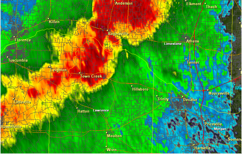
A tornado rapidly intensified near Wheeler Lake At the intersection of Lawrence, Lauderdale, and Limestone County around 4:47 pm CDT, Monday April 28th resulting in extensive damage across southwest Limestone County. Significant damage occurred at the Bay Hill Marina in Limestone County where a 2-story condominium was destroyed and a large metal Building structure (used to store boats) sustained nearly complete failure of its exterior frame. Additional residences and condos had roof and exterior wall/siding damage and numerous large trees were snapped or uprooted. Several docks with metal protective coverings were destroyed. The tornado was near its peak intensity across this area, with winds between 120 and 140 mph. The tornado continued east-northeast snapping numerous power poles near their bases along Snake Road. Along Log Cabin Road, just South of Highway 72, several homes sustained significant (if not complete) roof loss along with partial collapse of exterior walls. One single-family residence slid several feet off its concrete slab foundation. A trailer was also completely destroyed. The tornado maintained high-end EF-2/low-end EF-3 strength as it crushed Billy Barb`s Trailer Park on highway 72 in the Coxey community. 25 units were completely destroyed or uninhabitable. Two confirmed fatalities occurred at this location, with at least a dozen others injured. Debris was thrown across highway 72 near Gordon/New Cut Road. The tornado crossed Highway 72 entering a mainly rural area of Limestone County. Numerous trees were snapped or uprooted on either side of Highway 72 between Blue Springs Road and Parker Road. The last significant area of damage occurred at a neighborhood community near the intersection of Seven Mile Post and Guinn Road. At this 10-acre location, nearly ever home (concrete masonry unit) sustained some damage with at least a half dozen destroyed. One unit was swept clean off its foundation but was not anchored/secured to its foundation. The tornado continued east-northeast producing mainly EF-0 and EF-1 damage, minor roof/siding damage and snapped or uprooted trees, before gradually lifting just north of Athens near the intersection of West Elm Street and North Jefferson Street. It should be noted that sporadic damage (mainly trees snapped or uprooted) was seen extending at least 1/2 to 1 mile on either side of the center track of this tornado. This damage was not included in the path width. Other notes, two more supercells crossed nearly the same areas following this tornado. Additional brief tornadoes could have occurred very close to this damage path. Further assessment may be needed as time allows. The start/end points of this track could also be adjusted pending further storm damage information. Appreciation to the Limestone County Emergency Management Agency for their assistance in conducting this storm survey. Start Time: 4:47 PM CDT (April 28, 2014) End Time: 5:14 PM CDT (April 28, 2014) |
||||
|
|
||||
|
||||
|
Return to Top of Page
|
||||
| Russellville [EF-1] | ||||
|
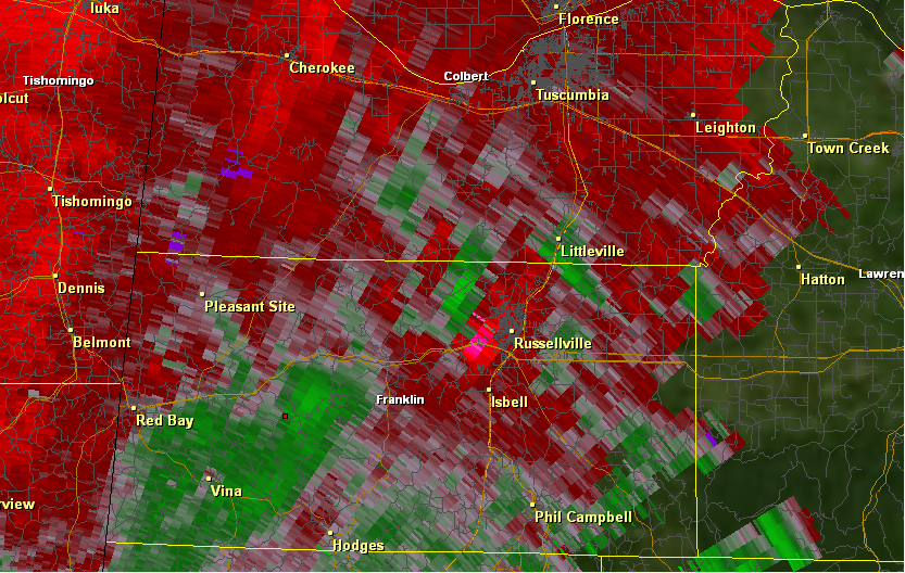
A tornado first touched down along Whitten Road near the intersection of Willis Road on the northwest side of Russellville. Trees were uprooted in this area and small trees were snapped. The tornado tracked northeast approaching the school complex. Here a tree was snapped and fell onto a house along Clay Avenue causing significant structural damage. The school complex along Summit Avenue sustained damage to its athletic fields and one awning at the elementary school was damaged. Across the street several trees were snapped near the base and a home sustained minor roof damage. The tornado then appeared to weaken briefly with only very light damage noted over the next 2 miles before touching back down near Alpine Street. Here numerous hardwoods were twisted, mangled, and snapped. Several trees fell on houses causing substantial structural damage. The tornado reached its maximum intensity of EF-1 with a width of approximately 100 yards. Interviews with several residents indicated that they observed a multiple funnel type of tornado track across the neighborhood. The tornado lifted northeast and weakened as it produced minor tree damage along Mountain View Drive before dissipating. Start Time: 3:56PM CDT (April 28, 2014) End Time: 4:02PM CDT (April 28, 2014) |
||||
|
|
||||
|
||||
|
Return to Top of Page
|
||||
| Welti/Berlin [EF-3] | ||||
|
A tornado first touched down in the Welti community along CR 636. Numerous hardwood trees were snapped and uprooted in this area. The tornado continued to move north with significant damage to a one story home along CR 601. Major roof uplift was noted to this home and a building under construction at the same site was completely destroyed and blown several hundred yards. A large travel trailer was also rolled. Damage at this location was deemed EF-2 in intensity. Further north along the road a large outbuilding was completely destroyed. The tornado intensified as it moved northward crossing the Broglen River. Here the tornado widens to near 350 yards. Many hardwood trees were snapped and uprooted along the path. A chicken farm sustained damage along CR 732. Near this location along CR 736 a well constructed two story brick home sustained severe damage when the upstairs was completely wiped away and blown several hundred yards into a ravine. The occupants of the home were interviewed and stated they received the warning and sheltered safely in their basement. Large debris missiles were seen embedded in the surrounding fields. Several trees in this area were also severely mangled and partially debarked. Damage in this area was rated low end EF-3. The tornado continued to track northward ripping the roof completely off a home at the intersection of CR 736 and 703. The tornado intensity oscillated as it tracked northward toward the Berlin community. Numerous wooden power poles were snapped along CR 703. Numerous trees were snapped or uprooted as it crossed Highway 278 with some trees sheared near the base. A TVA substation suffered significant damage with large electrical lines damaged and poles snapped and destroyed. The survey team was not able to fully observe this damage due to security restrictions but online photos indicate that this particular damage is consistent with at least high end EF-2 or possibly EF-3 damage. A chicken farm sustained severe structural damage with one house completely wiped to the ground with the metal trusses severely mangled. 25,000 chickens were killed in this one location. A mobile home along CR 747 was completely destroyed with debris thrown over 50 yards. Additional tree damage was noted in this area. The tornado weakened quite rapidly after this point lifting just north of Hwy 69. Start Time: 9:39 PM CDT (April 28, 2014) End Time: 9:58 PM CDT (April 28, 2014) |
||||
|
|
||||
|
||||
|
Return to Top of Page
|
||||
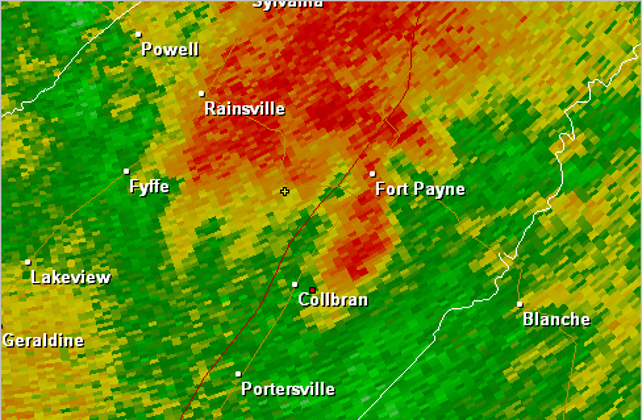
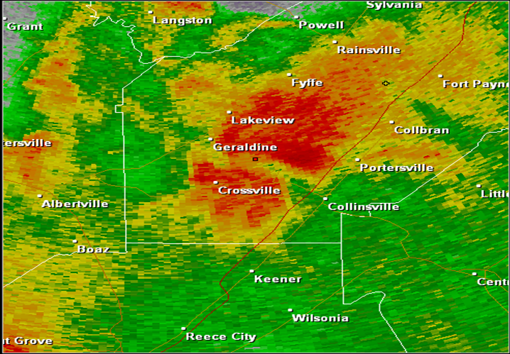
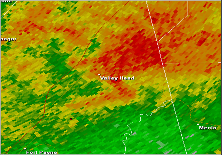
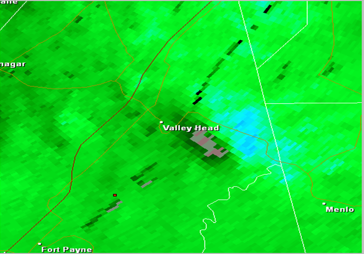
| Aroney [EF-3] | ||||
|
A tornado initially touched down just south of Brow Road in northern Etowah County, about 4 miles east of Sardis City, snapping and uprooting many trees. The tornado rapidly intensified as it tracked northeast and crossed Liberty Hill and Horton Gap Roads. Severe damage occurred along Liberty Hill Road where a home was lifted off its block foundation and moved about 60-80 feet from its original location. Despite this, most of the exterior walls (and even a portion of the roof) remained Intact. Numerous trees around this property were snapped near the base indicating very strong winds. Just west of this location, several manufactured homes/trailers were completely destroyed. Two other homes sustained significant roof loss and exterior wall damage. Along Horton Gap Road, a two-story home was destroyed with just a few interior walls left standing. Much of the debris was thrown several hundred yards away from its original location and trees were literally ripped out of the ground and thrown. Just northeast of this location, a large wood-framed chicken house was destroyed. At these locations, the tornado was at its peak intensity with winds estimated between 135 and 155 mph, giving it a rating of EF-3. On either side of the center line track, damage was seen along Owens road (west of the track) and Roden Road (east). Structural damage resulting in loss of roof and exterior walls/side panels was seen along with numerous trees snapped or uprooted. The tornado crossed very near where the Roden and Owens Roads intersect, just south of the Etowah/DeKalb County line. The tornado continued to be strong (EF-2 intensity) as it crossed into DeKalb County. Just south of where CR 4 and 450 meet, a manufactured home was completely destroyed. The undercarriage was so badly mangled and twisted up, it was nearly unrecognizable. Trees were also debarked at this location. Where CR 4/450 and 455 meet, a single-story home was heavily damaged and shifted off its foundation. Nearly the entire roof was lifted. The tornado continued to produce damage as it tracked northeast, crossing CR 25. The tornado was at least 1/4 mile wide At this point with noticeable damage seen along CR 4 (east of the center track) and CR 455 (west of the track). The tornado then took a slight jog to the north and crossed CR 457 and 29 where several homes sustained significant loss of roof covering/shingles and trees were either snapped or uprooted. The tornado appeared to enter a weakening phase at this point. On the west side of the track, a small farm outbuilding collapsed and a large oak tree fell on top of a home along CR 29. Trees were either uprooted or snapped along CR 1920. The tornado crossed CR 4 again (just north of CR 1920) and approached the higher terrain/ridgetop area west of Dugout and Little Sand Valley. Trees were seen snapped or uprooted. A barn was destroyed along CR 4, just south of Coal Creek. The tornado had narrowed significantly by this point but was still producing winds between 80-90 mph. Nearing the end of its life, the tornado crossed Highway 227 over the higher terrain, snapping and uprooting a narrow corridor of trees. Just north of highway 227, along CR 12 just north of Hayes Gap, additional trees were snapped. This matched up fairly well with the diminishing radar debris signature and broadening circulation depicted by radar velocity products. No additional/definitive damage was seen north of this location, therefore the preliminary `End Point` is placed in the higher terrain just north of CR 12 and west of CR 221 in southern DeKalb County, about 4 miles southeast of Crossville. Start Time: 12:32 AM CDT (April 29, 2014) End Time: 12:47 AM CDT (April 29, 2014) |
||||
|
|
||||
|
||||
|
Return to Top of Page
|
||||
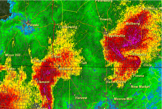
| Hazel Green/Charity Lane [EF-1] | ||||
|
A tornado touched down along Charity Lane between Stafford and Butter-and-Egg Roads. It tracked almost directly eastward along Charity Lane, snapping and uprooting hundreds of trees and causing minor roof damage to multiple houses. At Charity Baptist Church, the tornado uprooted a very large oak tree believed to be around 150 years old. It began tracking more to the northeast as it reached Frank Patterson road, continuing to snap many more trees in the Hazel Trace and Hazelwood Drive area. It crossed Highway 231/431, collapsing a carport near Carriger road. The tornado continued to snap and uproot many more trees along Mulberry Road, Bevills Church Road, Greenville Pike, and Everett Jones Road. The tornado dissipated just east of Everett Jones Road, just south of Borderline Road and the Tennessee State Line. Note: damage noted to a convenience store along highway 231/431 near the Bobo Section Road intersection was determined to be straight line wind damage associated with the tornadic storm. Based on the construction of the store, wind speeds were estimated at 75-80 mph. Start Time: 5:50 PM CDT (April 28, 2014) End Time: 6:05 PM CDT (April 28, 2014) |
||||
|
|
||||
|
||||
|
Return to Top of Page
|
||||
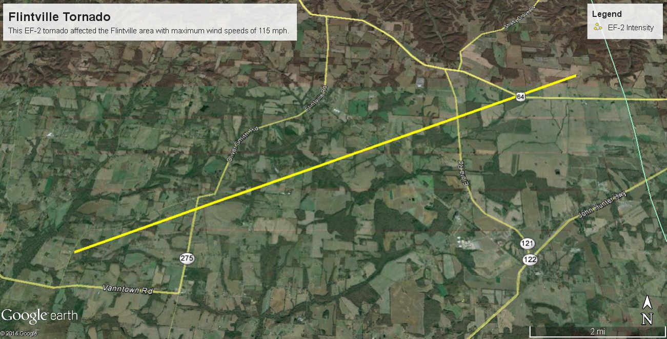
| Flintville [EF-2] | ||||
|
The tornado touched down along North King Road, near the intersection with Lincoln Loop Road. It snapped and uprooted many trees along Lincoln Loop Road then crossed Vanntown School Road. The tornado then damaged a farm complex along Stewarts Chapel Road, where it tore the roof off an office building, destroyed two metal sheds, and vaulted a metal silo 150 yards. It continued tracking northeast, snapping and uprooting numerous trees, and causing minor roof damage to single family residences. One large tree fell onto a residence along Wells Lee Road. The tornado continued to snap and uproot numerous trees as it crossed Flintville School Road and Elora Road, with minimal structural damage noted. As it crossed Highway 64 east of Old Elora Road, the tornado pushed a mobile home off its foundation. At this stage, the tornado appeared to weaken, causing progressively weaker tree damage as it crossed Hotel/Terry Dunavan Road north of Highway 64. It is believed to have dissipated between Hotel/Terry Dunavan road and the Franklin County Line. Start Time: 6:09 PM CDT (April 28, 2014) End Time: 6:24PM CDT (April 28, 2014) |
||||
|
|
||||
|
||||
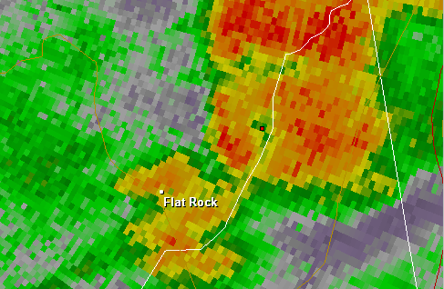
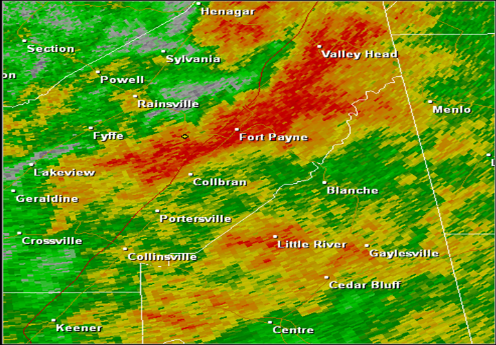
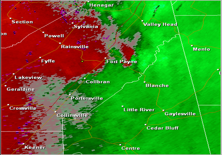
| Fort Payne/Pine Ridge [EF-2] | ||||
|
A previously tornadic cyclic supercell produced yet another tornado along County Road (CR) 209 where mainly branches were snapped. The tornado lifted northeast snapping additional branches before strengthening as it approached CR 52. Here, severe hardwood trees were snapped or uprooted near a farmstead. Additional trees were snapped and/or uprooted along a wide swath all along CR 88. The tornado may have weakened or even lifted very briefly as it crossed the Highway 35 intersection near Dugout Valley Road/CR 97 west-norhtwest of Fort Payne. The tornado intensified once again as it tracked norhteast, uprooting and snapping more trees. The tornado reached peak intensity with estimated winds of 115 mph and a path width of 200 yards near the intersection with Chisenhall Road. At this location, the tornado rolled and separated a mobile home from its frame, peeled roofing back from another mobile home, and snapped many trees in a forested area just northeast of the intersection. It continued to track along CR 97, but weakened significantly, causing mostly tree damage or very minor structural damage to single family homes (two homes sustained minor roof damage or broken windows just north of the Chisenhall/CR 97 intersection). The tornado narrowed significantly before lifting along CR 609 just north of the intersection with CR 27. Start Time: 1:06 AM CDT (April 29, 2014) End Time: 1:27 AM CDT (April 29, 2014) |
||||
|
|
||||
|
||||
|
Return to Top of Page
|
||||
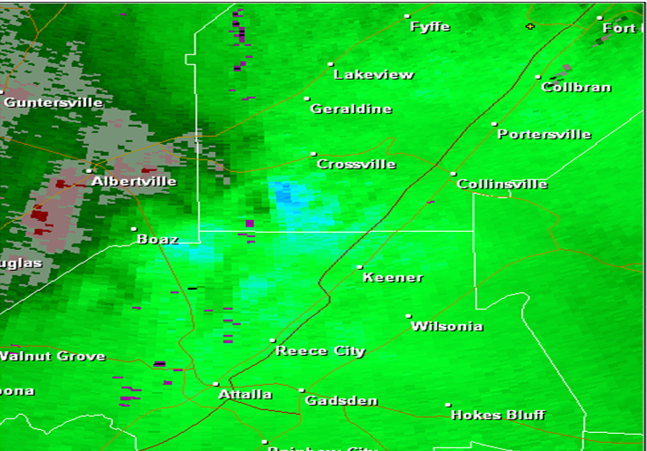
| Dawson [EF-2] | ||||
|
A tornado touched down in the community of Dawson along County Road 20. This would be the first of two tornadoes spawned by the same parent storm that produced the earlier Etowah-DeKalb County tornado. Numerous trees were snapped and/or uprooted in this area. The tornado tracked north-northeast snapping additional trees along County Road 199, and damaging a mobile home. Another home received minor structural damage along CR 196. The tornado fell a wide swath of trees before it crossed Highway 57. Here it reached maximum intensity, nearly destroying a small home. Several large farm buildings were significantly damaged near the intersection of CR 204 and 57. The tornado nearly paralleled the highway as it tracked further north. Another home sustained roof damage along CR 57 as well. The tornado began a weakening phase north of the intersection with CR 204, with mainly tree damage noted north of that location. The tornado finally lifted just north of the intersection of CR 57 and 109. Start Time: 12:54 AM CDT (April 29, 2014) End Time: 1:00 AM CDT (April 29, 2014) |
||||
|
|
||||
|
||||
|
Return to Top of Page
|
||||
| Shiloh/Higdon [EF-1] | ||||
|
A tornado touched down along County Road (CR) 326 in extreme eastern Jackson County, just south of the CR 324. It tracked northeast into extreme northern DeKalb County just south of Higdon, Alabama. Most of the damage observed was to trees...with multiple trees uprooted or snapped along the tornado path. The most significant damage occurred along CR 155 in DeKalb County near the intersection of CR 823. In this area, minor roof damage and underpinning damage was observed at several mobile homes. One single family house along CR 155 sustained more significant roof, carport, and siding damage. The tornado continued to move northeast, causing additional damage to homes, outbuildings, and one church. The tornado lifted along the Jackson/Dekalb County line just before reaching the Georgia state line. Start Time: 8:18 PM CDT (April 28, 2014) End Time: 8:29PM CDT (April 28, 2014) |
||||
|
|
||||
|
||||
| Mentone [EF-1] | ||||
|
A tornado touched down south of Mentone along the Desoto Parkway (CR 89) just south of the intersection with CR 165. Here, several large cedar trees were snapped. The tornado moved northeast, paralleling the western side of CR 165. Mainly tree damage was noted in this area, with minor structural damage to barns and outbuildings. Several stands of old growth hardwoods were damaged here. The tornado seemed to weaken briefly with only minor tree damage noted near downtown Mentone. Further up the slopes of Lookout Mountain, the tornado strengthened again to EF-1 intensity, with sporadic swaths of hardwood trees snapped or uprooted, all along the eastern side of CR 89, before lifting just inside the state line. Start Time: 1:36 AM CDT (April 29, 2014) End Time: 1:51 AM CDT (April 29, 2014) |
||||
|
|
||||
|
||||
|
Return to Top of Page
|
||||
| Aroney #2 [EF-0] | ||||
|
A small tornado touched down in the Aroney community in the southwest corner of DeKalb County. The tornado first touched down along County Road 479. Here minor roof damage was noted to a single family home, and a farm building was also damaged. Minor damage was also noted to trees all along CR 479. Several small hardwood trees were snapped just north of CR 10, and other trees had the tops snapped off in this area. Another barn sustained minor roof damage further north along the road, and a home sustained very minor damage. The tornado eventually lifted just south of Highway 168 near the Kilpatrick Community. Start Time: 1:28 PM CDT (April 29, 2014) End Time: 1:32 AM CDT (April 29, 2014) |
||||
|
|
||||
|
||||
|
Return to Top of Page
|
||||
| Pumpkin Center [EF-1] | ||||
|
Damage was first noted just south of Bird Dog Trail at the southern end of a large farmstead. Numerous trees were snapped and uprooted and a large 40 FT by 50 FT barn was destroyed. This brief tornado appeared to be at its peak intensity near this location (100 mph winds). It should be noted that the barn damage was cleaned up at the time of the survey, but the homeowner confirmed the barn had totally collapsed. Several trees were snapped adjacent to the west side of a house which had no major damage. The short lived tornado moved northeast with additional trees snapped or uprooted just across Bird Dog Trail (north side). Two by fours and tin from the barn was seen here on the ground and in the trees. The homeowner also noted that tin from the barn was seen here on the ground and in the trees. The homeowner also noted that tin from the barn roof was tossed to at least the end of the tree line, which is approximately 1/3 of a mile away. The tornado then crossed a rural/forested area to the intersection of Pumpkin Center Road and CR 153/Fletcher Road. Small to medium sized branches were brought down at the southwest corner of this intersection. No additional damage was seen downstream from this location but very limited road access existed. Start Time: 2:23 AM CDT (April 29, 2014) End Time: 2:25 AM CDT (April 29, 2014) |
||||
|
|
||||
|
||||
|
Return to Top of Page
|


 Local Radar
 Weather Map