A second Pacific cold front will cross the Pacific Northwest Wednesday followed by another atmospheric river. Each of these features will bring additional periods of gusty winds, mountain snow, and heavy to excessive rainfall with renewed flooding. Heavy lake effect snow continues into Tuesday east of Lakes Erie and Ontario. Read More >
| Fast Facts | Reports | Photos | Meteorology & Radar | Other Links |
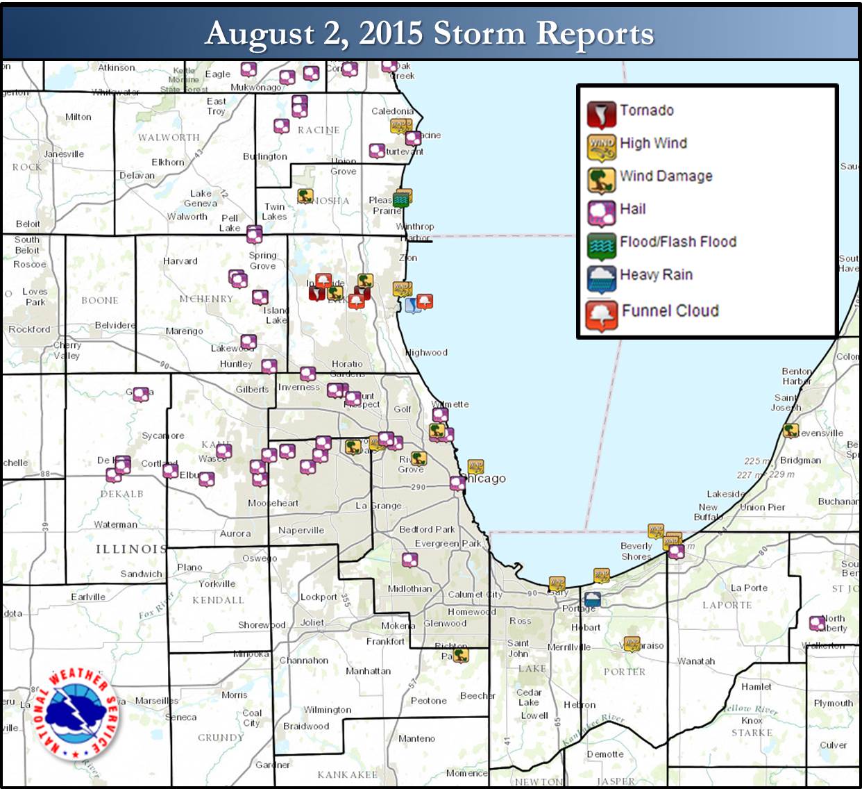
There were two severe weather episodes on August 2nd. In the afternoon, a single severe storm produce large hail and wind damage, with the wind damage including to a tent collapse leading to injuries and a fatality in Wood Dale. The second episode included an EF-1 tornado with peak winds of 100 mph in Lake County. This tornado had no reported injuries.
The early afternoon storm in DeKalb County moved east, producing numerous reports of hail greater than 1" in diameter for its ~60 mile path. In addition this storm produced wind gusts in excess of 50 mph near O'Hare Airport, and continued to produce large hail across the Chicago Metro area. After Wood Dale, significant wind damage continued northeast to Evanston and the Rogers Park neighborhood of Chicago
Very warm and windy conditions were also observed Sunday afternoon, with highs reaching the lower 90s across portions of Northeast Illinois. Wind gusts, not associated with thunderstorms, ranged from 30 to 40 mph in the mid and late afternoon hours.
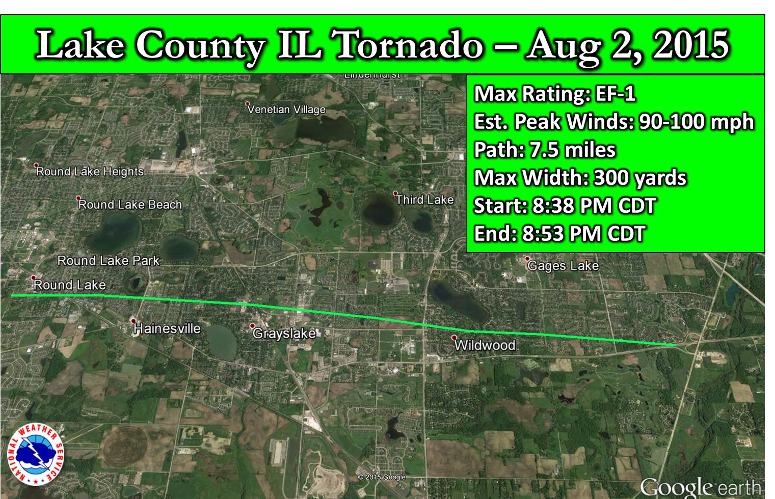
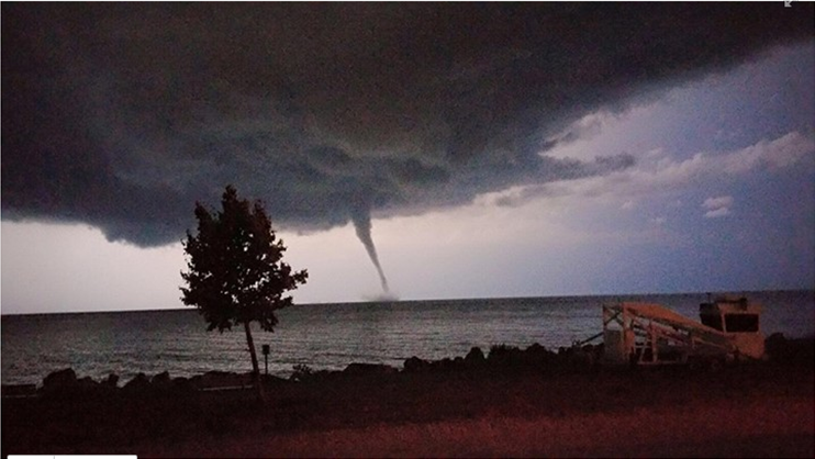
Across Lake County in Illinois, there was a supercell storm which rapidly produced an EF-1 tornado across Round Lake, Hainesville, Grayslake, and Wildwood, IL. This storm went on to produce a waterspout northeast of North Chicago over Lake Michigan.
A line of severe storms continued to slide south from Wisconsin, and moved into far Northeast Illinois late in the evening. This line of storms continued to produce severe weather over Northern Illinois into Northwest Indiana through early Monday morning.
Reports and Survey Information
PUBLIC INFORMATION STATEMENT
NATIONAL WEATHER SERVICE CHICAGO IL
835 PM CDT MON AUG 3 2015

...NWS DAMAGE SURVEY RESULTS FOR AUGUST 2 2015 LAKE COUNTY IL
TORNADO...

.ROUND LAKE TO HAINESVILLE TO GRAYSLAKE TO WILDWOOD IL...

RATING:                 EF-1
ESTIMATED PEAK WIND:    90 TO 100 MPH
PATH LENGTH:            7.5 MILES
MAXIMUM PATH WIDTH:     300 YARDS
FATALITIES:             0
INJURIES:               0

START DATE:             AUGUST 2 2015
START TIME:             838 PM CDT
START LOCATION:         0.5 MI SSW OF ROUND LAKE IL
START LAT/LON:          42.3503 -88.0972

END DATE:               AUGUST 2 2015
END TIME:               853 PM CDT
END LOCATION:           WILDWOOD IL
END LAT/LON:            42.3428 -87.9505

SURVEY SUMMARY:

A SUPERCELL THUNDERSTORM QUICKLY PRODUCED A TORNADO THAT FIRST
RESULTED IN TREE DAMAGE IN ROUND LAKE NEAR CEDAR LAKE ROAD. THE
TORNADO THEN MOVED EAST...AND ALONG ITS 7.5 MILE PATH DAMAGED HUNDREDS
OF TREES INCLUDING DOZENS AT THE BASE AND DOZENS BEING UPROOTED.
THE MOST SIGNIFICANT TREE DAMAGE WAS CONSISTENT WITH MID EF-1
INTENSITY AND WHEN THE TORNADO WAS AT ITS WIDEST IN SUBDIVISIONS OF
GRAYSLAKE AND WILDWOOD. A ROOF WAS BLOWN OFF OF A RESTAURANT ALONG
ILLINOIS ROUTE 134...WITH A SIGN FROM THE RESTAURANT ENDING UP OVER
TWO MILES AWAY IN GRAYSLAKE. SEVERAL HOMES AND BUSINESSES SUFFERED ROOF
DAMAGE FROM EITHER FALLING TREES OR LOSS OF SHINGLES. A LARGE PART OF
THE ROOF OF THE GRAYSLAKE CENTRAL HIGH SCHOOL WAS BLOWN ACROSS THE
STREET. A NEARBY SKATEPARK WAS ALSO HEAVILY DAMAGED. THE LAST POINTS OF
DAMAGE WERE NOTED ALONG ILLINOIS ROUTE 120 JUST WEST OF INTERSTATE 94
IN UNINCORPORATED WILDWOOD.

AS AN ITEM OF INTEREST...THIS WAS THE FIRST TORNADO IN LAKE COUNTY
ILLINOIS SINCE APRIL 18 2002 WHEN A BRIEF EF-0 TORNADO OCCURRED. THIS
WAS THE LONGEST PATH TORNADO IN THE COUNTY SINCE JULY 6 1986.

THE NATIONAL WEATHER SERVICE WOULD LIKE TO THANK LAKE COUNTY EMERGENCY
MANAGEMENT FOR ASSISTING WITH THE SURVEY.

EF SCALE: THE ENHANCED FUJITA SCALE CLASSIFIES TORNADOES INTO THE
FOLLOWING CATEGORIES.

EF0...WEAK......65 TO 85 MPH
EF1...WEAK......86 TO 110 MPH
EF2...STRONG....111 TO 135 MPH
EF3...STRONG....136 TO 165 MPH
EF4...VIOLENT...166 TO 200 MPH
EF5...VIOLENT...>200 MPH


$$

FRIEDLEIN/MOTT/BATZEK/KRULL
| Waterspout Northeast Of North Chicago over Lake Michigan. Courtesy of Samantha Kornfeind |
 |
Facebook Photo Album of Severe Thunderstorms that Impacted Other Portions of the Area
A warm and unstable airmass was in place across Northeast Illinois and Northwest Indiana on Sunday. Temperatures by midday were in the upper 80s to low 90s. Dewpoints were in the mid 60s to low 70s.
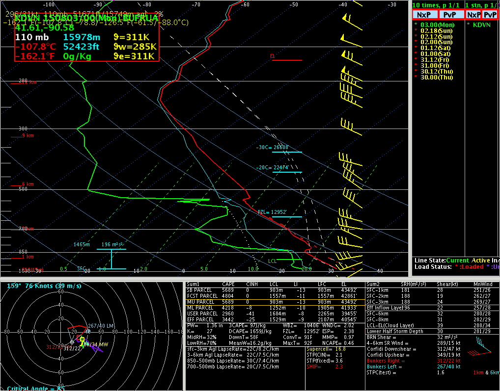
An area of upper level low pressure was just south of Hudson Bay, bringing fairly cold temperatures in the mid levels of the atmosphere over the region. The warm and moist airmass below these cold temperatures aloft lead to extreme instability across the area. All that was needed was a trigger to release this instability. This is well depicted by the 0000 UTC August 3 Upper Air Sounding from Davenport, IA (Figure 1). The red line is a temperature trace with height, and the green line is dewpoint. Due to these extreme conditions, the Quad Cities, IA office issued a special weather balloon sounding at 18z, which looked similar to this sounding.
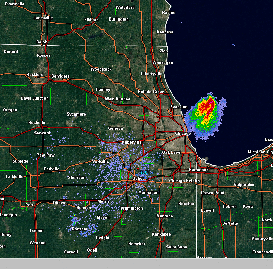
There was no large scale forcing on Sunday until later in the day, suggesting that storms would not be widepsread during the day. That was the case for the most part. but subtle forcing in northwest flow aloft was able to recognize that instability and lead the a lone thunderstorm that propogated eastward from Ogle/Lee counties of Illinois east thorugh the Northern Suburbs, on toward O Hare Airport and then through the north side of Chicago, producing large hail and a swath of damaging winds. (Figure 2)
A stronger disturbance moved through Wisconsin on Sunday afternoon and evening. A cold front was along the leading edge of this disturbance. An unseasonably strong surface low pressure moved into Southwest Wisconsin during the late afternoon and evening. This led to the breezy/windy conditions across the entire area on Sunday. This front lead to more active thunderstorms in Wisconsin during the afternoon, then shifted south in the evening.
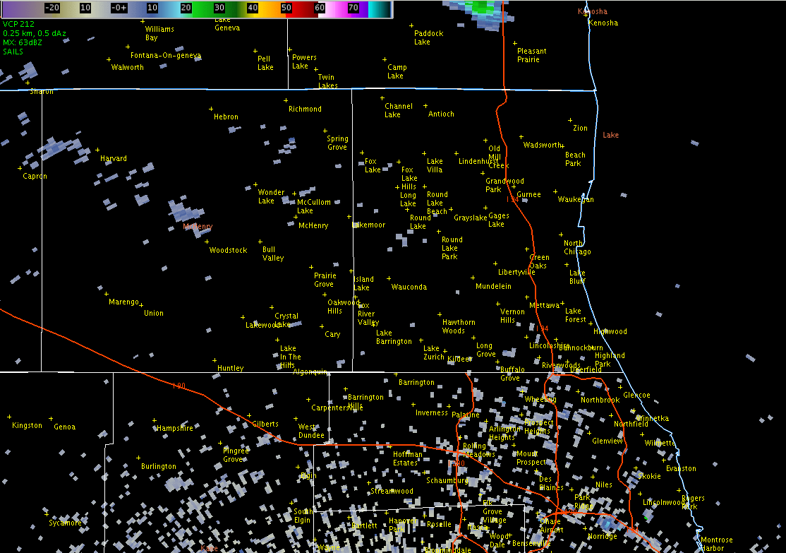
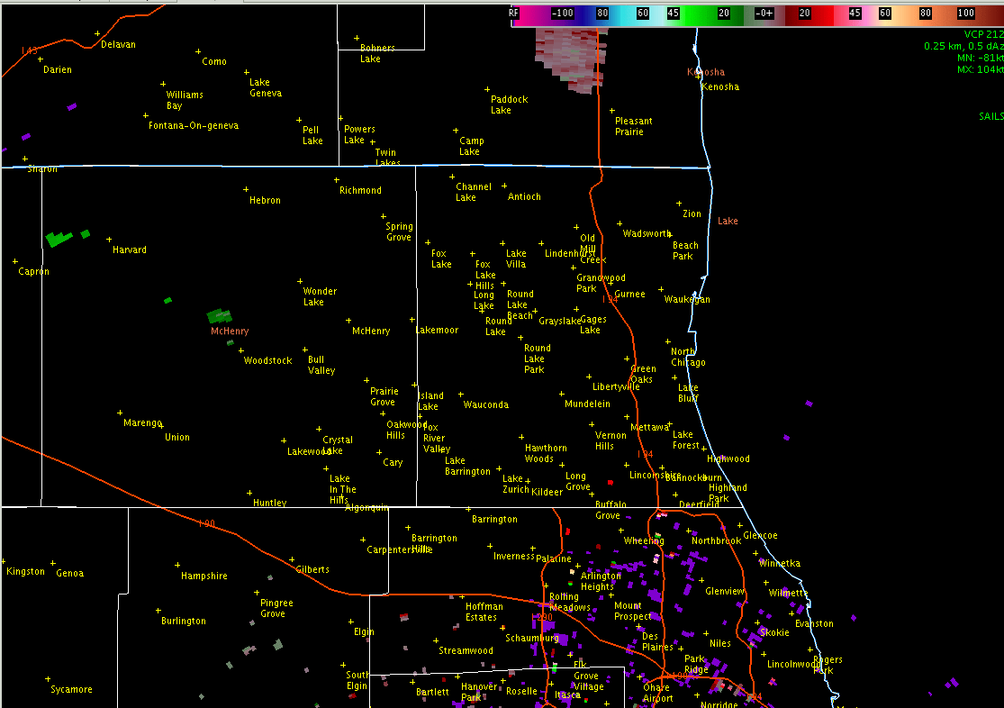
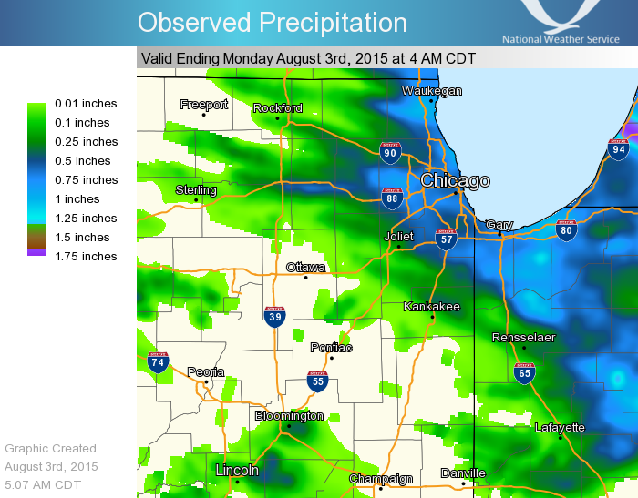
The low level winds were still very strong ahead of the surface low pressure area in Wisconsin leading to strong low level and deep layer wind shear (see Figure 1 again). While a line of thunderstorms produced hail, heavy rain (Figure 5), and damaging winds across the Chicago metro area during the evening, this strong shear coupled with high instability lead to the development of supercell storms ahead of the main line of thunderstorms. One of these supercells was the storm that went on to produce the tornado in Round Lake/Grayslake. (Figures 3 and 4) These storms were aided by outflow boundaries from storms in Wisconsin that moved out ahead of the main cold front.
| Figure 1: Upper Air Sounding at 0000 UTC August 3, 2015 from Davenport, IA |
 |
| Figure 2: NWS Chicago Radar Imagery of Early Afternoon Storm |
 |
|
NWS Chicago Radar Imagery of the Round Lake/Grayslake Tornado - Figure 3: Reflectivity (top) Figure 4: Velocity (bottom) |
|
|
 |
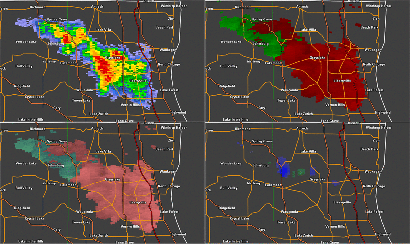
| Figure 6: 4 Panel Level II Radar - Round Lake/Grayslake Tornado |
|
Base Reflectivity (top left) Base Velocity (top right) Storm Relative Velocity (bottom left) Normalized Rotation - NROT (bottom right) NROT - Helps depict area of strongest circulation |
 |
| Figure 7: Observed Precipitation |
 |