Chicago, IL
Weather Forecast Office
Climate facts:
Chicago Midway 3SW: The long time COOP observer has had six 6+" events this late in the season since 2000, with the last being 6.0" on March 11-12, 2014.
Kankakee, IL: The long time COOP observer has only had two 6+" events this late in the season since 2000, with the last being 6.2" on March 6, 2013. There has not been an 8+" observed event this late in the season since 8.1" on March 9-10, 1998.
Rensselaer, IN: The long time COOP observer has only had one 8+" event this late in the season since 2000, and that was 9.0" on March 6, 2013.
|
Weather Story Graphic |
|
|
|
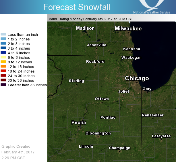
Snowfall Forecast
|
|
NWS Headlines Across the Country |
|
|
Definition of Watches, Warnings, & Advisories
Hazards
Enhanced Hazardous Weather Outlook
Hazardous Weather Outlook
National Briefing
Skywarn
Outlooks
Watch/Warning/Advisory Criteria
Snow Squall Warnings
Local Forecasts
Marine
Aviation
Fire
Text Products
Great Lakes Marine Portal
Lake Michigan Beach Forecast
El Nino
Snow and Ice Probabilities
Past Weather
Holiday Climate Data
Climate Plots
Weather Event Write-Ups
Stormdata
Education
Jetstream
Play Time for Kids
Student Opportunities
US Dept of Commerce
National Oceanic and Atmospheric Administration
National Weather Service
Chicago, IL
250 George J Michas Dr.
Romeoville, IL 60446
815-834-1435 8am-8pm
Comments? Questions? Please Contact Us.