
Heavy lake effect snow and gusty winds, including some local blizzard conditions, will continue into Thanksgiving Day across the Great Lakes then lingering through Friday night for Lakes Erie and Ontario. Confidence is increasing for another winter storm to develop over the northern and central Rockies Friday and track across the central Plains through the Midwest and Great Lakes this weekend. Read More >
Derecho
June 29, 2012
Chris Strong
NWS Baltimore/Washington
Warning Coordination Meteorologist
The Midwest/Mid-Atlantic Derecho of late June of 2012 was an extraordinary event in our region's weather history. While squall lines of thunderstorms are common here, this line was an atmospheric bomb, releasing the tremendous amount of energy in the atmosphere on that record hot June day...and the fuse that triggered it was all the way back in Iowa.
During the day on June 29th, the big news story of the day was how hot it was. Record high temperatures were expected, and it ended up being the hottest day ever recorded in June for Washington, reaching 104 degrees that afternoon with a heat index near 115. Our office conducted numerous interviews with our area's media organizations talking about the record warmth, and how long it would last. While scattered thunderstorms were expected in the heat later that day, there was no significant feature in the atmosphere passing over us that day (such as a cold front) to focus the energy and cause undue alarm for organized, severe thunderstorms.
The seed for what became this highly destructive weather event occurred half-way across our country between Chicago, Illinois and Des Moines, Iowa late that morning. A complex of showers and thunderstorms that had been drifting northeast through Iowa got caught by the edge of the jet stream. That current of air high in the atmosphere extended from the High Plains through the Great Lakes to the Northeast U.S., and offered the perfect conduit to steer that cluster of storms quickly in our direction.
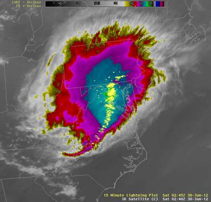
As the morning turned to afternoon, the area of showers and thunderstorms turned into a squall line as it moved to the east-southeast, fueled by the heat and humidity over the Midwest. In a more typical day, thunderstorms take the heat from near the hot ground and loft it high in the atmosphere in their updrafts. They replace it with downdrafts of colder air from a few miles up, high in the storm. On June 29th, the way the atmosphere was setup, not only did the excessive heat and humidity allow for extremely powerful updrafts and downdrafts in the storms, but the line of storms was traveling at just the right speed so that the cold air it was pushing to the ground never overtook the hot air that was rising into the storms. This steady-state allowed the storms to continually replenish themselves as they traveled hundreds of miles to the Atlantic Coast and beyond.
The power of the squall line that day was a direct result of the extreme heat and humidity that the storms traveled through that day. Everything in nature is a matter of scale, and while squall lines are common in summer here - this was the category 5 of squall lines (informally borrowing from our tornado & hurricane scales). While it is rare to have a squall line here as powerful and destructive as Derecho 2012 was, they do happen from time to time. Another, though not as devastating one, occurred in the Mid Atlantic in June 2008. Another occurred in July 1980. The Washington Post recently even uncovered an article from a similar event in Washington D.C. in 1954.
The storms passed through the Mid Atlantic between 8 P.M. and 1 A.M., leaving extensive wind damage from a 250 mile long gust front that packed 40+ mph wind gusts for nearly everyone, and extreme wind gusts of 70-90 mph in targeted locations. Between 6:30 - 7:30 P.M. that Friday evening, NWS Baltimore/Washington realized that the Appalachian Mountain range that often serves as a "weather divide" was not going to disrupt these storms, and the region was in jeopardy. Severe Thunderstorm Watches were raised, and statements were issued that included "major wind damage...due to wind gusts over 75 mph". Severe Thunderstorm Warnings soon followed, in advance of the line of storms that moved east to the Atlantic.
What was left in its wake was a power outage so extensive, it could be seen from weather satellites. Power was out for many days in some areas, as crews worked feverishly to repair what nature had destroyed. The heat continued, and many were left to suffer through it without the expected amenity of air conditioning - which became a real danger to some. Trees blocked roads, ATMs and gas stations were rendered useless without power, stoplights were dark, communications antennas (including those for cell phones) were degraded or inoperable.
It was an amazing display of nature's ability to take a simple cluster of showers and thunderstorms nearly a thousand miles away, and turn it into one of the "squall lines of record" for our region… a line of such destructive power that it decimated our infrastructure, and dramatically affected everyday life of nearly everyone in our region - Derecho 2012.
For a more detailed look at the event with many images & animations, check out this exceptional article written by our Science & Operations Officer, Steve Zubrick. Also, the NWS’s Storm Predicition Center wrote this thorough article on the event from the national perspective.


 Coastal Flood
 FAQ
FAQ