Springfield, MO
Weather Forecast Office
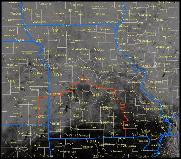
| Visible satellite imagery from Sunday December 16th shows the vast snow field across the region that extended from Northeast Oklahoma, Kansas, Missouri, Nebraska, Iowa and Illinois. The area outlined in red is the county warning area that the National Weather Service in Springfield, MO serves. |
|
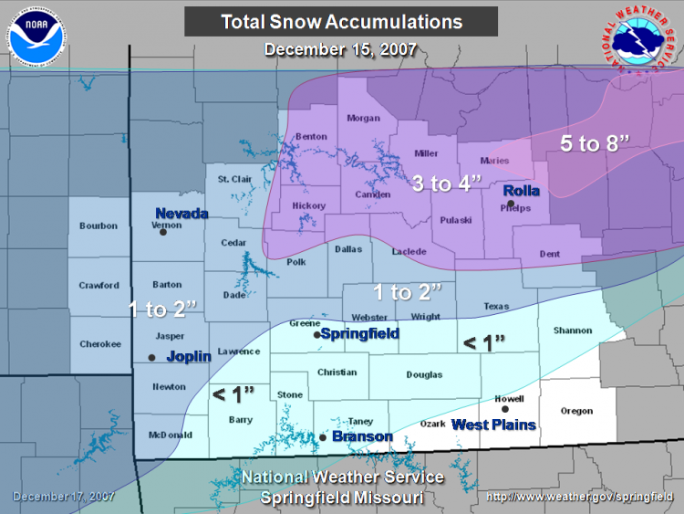
...Snowfall Totals December 15th Event... A winter storm brought light to moderate snow accumulations to southeast Kansas and the Missouri Ozarks Saturday December 15th. Precipitation began as a wintry mix of freezing rain...sleet andsnow Friday night with the first round of the storm. The second round brought snow to the region Saturday afternoon and evening. Total snow accumulations generally ranged from one to two inches north of interstate 44 with less than an inch to the south. Heavier accumulations of 3 to 4 inches fell across portions of Central Missouri from the Lake of the Ozarks region east to Rolla and Salem. Even higher snow amounts of up to 8 inches fell further northeast in the St. Louis area as the storm system continued to intensify. A couple of factors limited snow accumulations across the Missouri Ozarks and southeast Kansas. First a thin layer of warm air aloft kept precipitation from changing over to snow as quickly Friday night. On Saturday the primary storm system did not intensify until it tracked northeast toward the St. Louis area. Snow accumulations from volunteer and cooperative observers...and Law enforcement across southeast Kansas and the Missouri Ozarks... County Summary... County Snow accumulation
Bourbon 2 to 3 inches Missouri: Vernon 2 to 3 inches |
Current Hazards
Experimental Graphical Hazardous Weather Outlook
Submit a storm report
Local Storm Reports
Current Conditions
Observations
Lake Levels
Snowfall Analysis
Road Conditions
Satellite
CoCoRaHS
Graphical Conditions
Regional Max/Min Temp and Precip. Table
Precip. Analysis
Forecasts
Forecast Discussion
Fire Weather
Aviation
GIS Forecast Maps
Activity Planner
Severe Weather
Winter Weather
Hurricanes
FAA Center Weather
Space Weather
Climatology
Records and Normals
Monthly Climate Summary
Local
National
Drought
Climate Science
Astronomical Data
US Dept of Commerce
National Oceanic and Atmospheric Administration
National Weather Service
Springfield, MO
Springfield-Branson National Airport
5805 West Highway EE
Springfield, MO 65802-8430
Business: 417-863-8028 Recording: 417-869-4491
Comments? Questions? Please Contact Us.


 Weather Story
 Weather Map
 Local Radar