| A Review of Local Weather in 2004 |
The year 2004 will long be remembered by residents of Florida as the year of the hurricane. Four hurricanes and one tropical storm menaced the state this year. This is the first time in recorded history that four hurricanes affected the state in one season. To add insult to injury, two of the four hurricanes were classified as major hurricanes. The Florida Big Bend and eastern portions of the Panhandle were directly impacted by Tropical Storm Bonnie, and Hurricanes Frances, Ivan and Jeanne. Fortunately for local residents, in all four cases, we were either on the periphery of the storm, or the storm had weakened considerably by the time it reached our part of the state. Nevertheless, tropical storm conditions impacted the area during Frances, Ivan and Jeanne. Bonnie's tropical storm force winds remained offshore. Ivan also spawned a devastating tornado outbreak across portions of the Panhandle and Southwest Georgia. Details on this season's tropical cyclones can be found further down the page.
As can be seen in Figure 1 (below), temperatures were cooler than normal during most of the first four months of the year, with a transition to a prolonged period of above normal temperatures in May. The remaining summer months were generally cooler than normal. For the second summer in a row, and the third time in four seasons, temperatures failed to reach the century mark anywhere in the forecast area. Beginning in late September, and continuing through October, November and the first two weeks of December, autumn temperatures averaged well above normal. A sharp turn to colder weather occurred in mid December and lasted through the Christmas holiday weekend. Mild weather returned for the last few days of the year. Figure 2 (below) shows that Tallahassee ran a precipitation deficit throughout the entire year. Frequent heavy rains in late January and February nearly erased the initial deficit, but a near record dry spell in March quickly reestablished the shortfall. The remainder of the spring was also typically dry. Summer rains were plentiful through June and early July, but another dry spell over the next month erased most of the gains. Above normal rainfall occurred during the 6-week interval that the area was plagued by the four tropical systems, but rainfall amounts were not overly excessive in Tallahassee, and the deficit continued. Near normal rainfall occurred through the autumn and into December. The annual rainfall total was 56.86 inches in Tallahassee, which is 6.35 inches below normal. Following are some of the weather highlights that occurred in the NWS Tallahassee County Warning & Forecast Area in 2004.
Another Colder than Normal Winter
The year started out on a very warm note with temperatures reaching the mid to upper 70s from the 2nd through the 5th. However, the remainder of the winter season was colder than normal (see Figure 1 below), but not as cold as recent winters. Morning low temperatures were below freezing in Tallahassee on 13 of the 31 days of January, but only three of these were hard freezes. Apalachicola, FL, tied their daily record low temperature for the 29th at 28 degrees. This date also saw the lowest temperature of the calendar year in Tallahassee when the mercury dipped to 23 degrees. This means the coldest temperature of the 2003-04 winter season in Tallahassee occurred in December (21 on the 21st). January 2004 was nearly 2.5 degrees warmer than December 2003. The coldest afternoon of the season occurred on January 10th, when the mercury never rose above 45 degrees. February was three degrees cooler than normal with three freezes during the month. Two more light freezes occurred at Tallahassee in March, which was otherwise a warm month. The last freeze of the season at the airport occurred on March 23rd. Apalachicola tied a record high temperature for the date on the 21st when the mercury reached 82 degrees. Panama City also tied their record that day, reaching 81. Tallahassee reached the 80-degree mark for the first time of the season on March 7th with a high of 82 degrees.
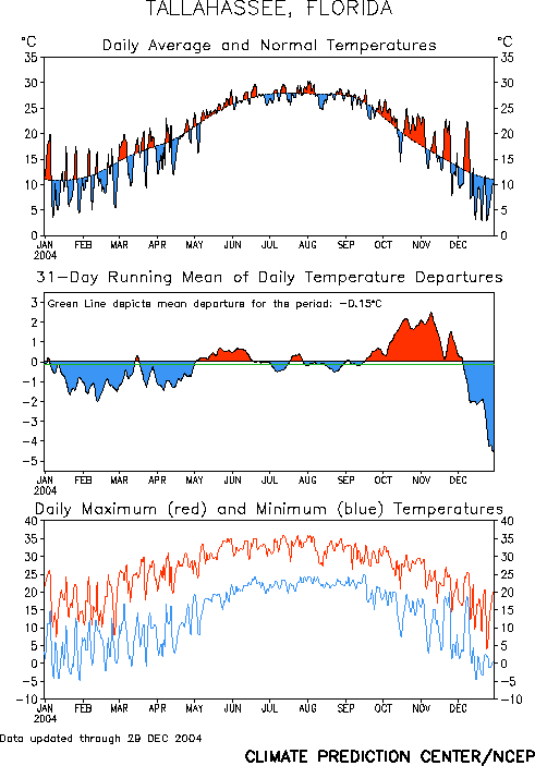
Figure 1. Temperatures in Tallahassee during the year 2004.
Very Dry Spring
March is typically a wet and stormy month in this part of the country, but March 2004 was one of the driest on record across the region. Apalachicola, FL, experienced its driest March of all time. Only 0.06" of rain fell in the city during the month, which beat the 96-year-old record of 0.26" set in 1908. Measurable rain fell on only three days during the month. Tallahassee and Panama City, FL, and Albany, GA, all saw their second driest March on record. In Tallahassee, a mere 0.24" fell, while PC got 0.82" and Albany picked up just 0.26 inches. April and May were also quite dry, save for one day of heavy rain on April 30th, when 2.12" of rain fell in Tallahassee. Only 1.33" fell during the remainder of the month. In May, only 0.91" of rain fell in Tallahassee, less than 1/5th of normal. Apalachicola and Panama City picked up less than half an inch during the month. The dry weather allowed temperatures to radiate efficiently at night with a few daily record low temperatures tied or broken in mid April. In Tallahassee, the low of 37 on the 15th broke the record for the date set in 1971. Albany, GA, also broke their record on that morning, dipping to 39 degrees. Apalachicola broke daily records on the 14th and 16th with minimum temperatures of 40 and 44 degrees, respectively. Panama City, FL, also broke their record for the 14th when the mercury dipped to 42 degrees. Finally, Apalachicola broke the daily low temperature record for May 5th by 5 degrees when the temperature dropped to 47 degrees. This also tied the all-time minimum temperature record for the month of May, set previously on May 12, 1981. On the flip side, Apalachicola tied a record high for the date on May 25th at 91 degrees. Panama City, FL, broke daily maximum temperatures on three consecutive days from May 6-8th, with highs of 89, 92, and 93 degrees, respectively.
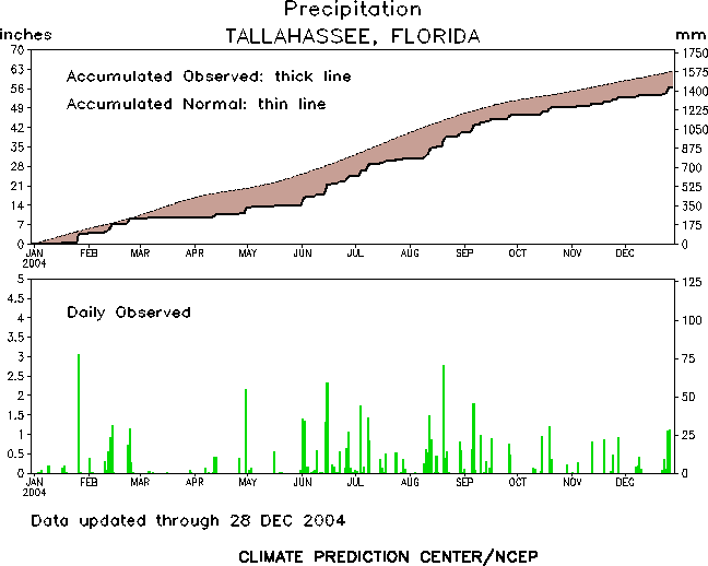
Figure 2. Rainfall in Tallahassee during the year 2004.
Another Wet Summer without Extreme Temperatures
For the second summer in a row, the mercury never reached the century mark across the forecast area. The summertime maximum temperature in Tallahassee was 97 degrees, which occurred four times, on July 12th and 24th and on August 1st and 3rd. Apalachicola's summer maximum was 95 degrees recorded on July 11th. The city also tied a record low on the 22nd, when the temperature dropped to 70, brrrr. Panama City reached its peak temperature on July 24th when the mercury soared to 98 degrees. This also tied the record for the date. Albany, GA, also reached 98 degrees on July 24th. This was the hottest temperature of the year recorded anywhere in the local forecast area.
Temperatures were once again tempered by abundant summer rains. June was the wettest month of the year across most of the region. In Tallahassee, 10.68" fell during the month, which is 3.76" above normal. Rainfall exceeded an inch on five different days. Albany, GA, also received nearly ten inches of rain in June. Dothan, AL, exceeded both totals with a whopping 14.44 inches of rain. This is without the aid of any tropical systems. July was drier than normal across the region, but the rains returned in August to central and eastern portions of the area. Tallahassee picked up 9.35" of rain for the month, over two inches above normal. This contrasts to Dothan, which received only 1.34". Tropical Storm Bonnie contributed to the monthly rainfall totals, although the wettest day of the month was not associated with this storm. Cross City received the most rainfall in the forecast area from Bonnie with 3.22" falling during the storm. Despite the fact that three tropical system impacted the area in September, rainfall totals were not excessive from Tallahassee west. In the capital city, just over six inches of rain fell during the month, which is only about an inch above normal. Areas west of Tallahassee had below normal rainfall for the month. Areas north and east of Tallahassee were not so lucky. Albany, GA, picked up 4.50" of rain when Frances crept north across the Peach State. Valdosta, GA, received over 5 inches of rain from both Frances and Jeanne. Combined with the rainfall from Ivan, the city received about a foot of rain from the three systems, for a monthly total of 15.55 inches.
Bonnie & Charley
Tropical Storm Bonnie was the first tropical system to impact Florida during this record-breaking hurricane season. Bonnie passed just south of Apalachicola, FL, before coming ashore along the Taylor Co. coast west of Perry early in the morning on Thursday, August 12th (Figure 3, below). While offshore buoys recorded sustained tropical storm force winds, none were observed over land areas. The peak gust at Tallahassee was just 20 mph. Perry and Cross City had peak gusts of 31 and 29 mph, respectively. Keaton Beach had the highest land-based observed winds, with sustained winds up to 33 mph and a peak gust of 37 mph. Excessive rains of over three inches were limited to the southeastern Big Bend (see above). Storm tides ranged from 1 to 2 feet along the Gulf Co. coast, to four feet along the Taylor Co. coast. Minor beach erosion occurred in Gulf Co., and at Alligator Point in Franklin Co. Water covered roads on St. George Island, and near the Taylor Co. coast, where up to 2000 people had evacuated. Downed trees and power lines caused scattered power outages, mainly along the coastal areas of the Florida Big Bend. Additional information on Tropical Storm Bonnie can be found here.
The very next day, Hurricane Charley came ashore well down the coast in Southwest Florida as a Category 4 hurricane. While hurricane warnings were posted as far north as Steinhatchee, maximum sustained wind speeds were well below tropical storm force across the northeastern Gulf of Mexico and the adjacent Florida Big Bend. Cross City, FL, picked up another 1.25" of rain from Charley, with lesser amounts further north and west. Charley proved to be nothing more than an inconvenience in this part of the state, mainly due to the fact that people that had already evacuated for Bonnie chose to remain in shelters until the threat from Charley had passed. Additional information on Hurricane Charley can be found here.
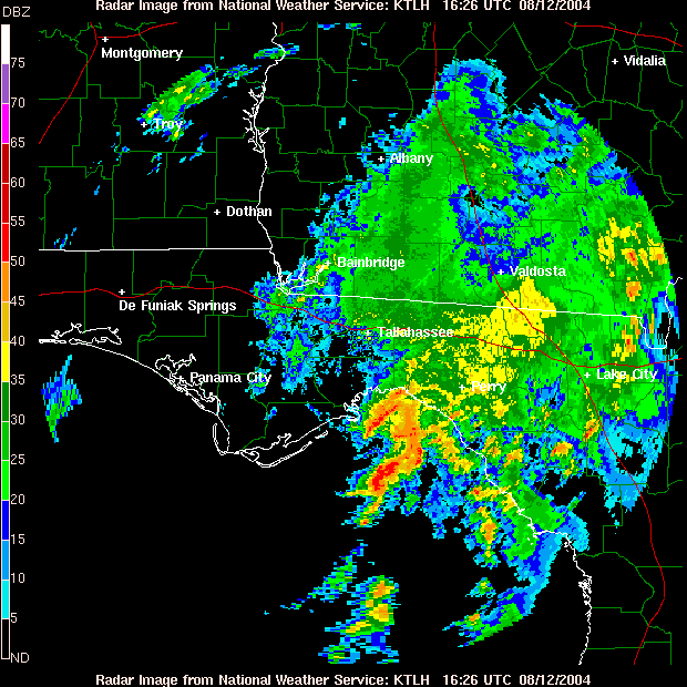
Figure 3. Doppler radar image of Tropical Storm Bonnie just before the storm made landfall along the Florida Big Bend coast, on the morning of August 12, 2004. Click on the image for a larger view.
Frances
Hurricane Frances came ashore on the east coast of Florida near Sewall's Point during the early morning hours of September 5th. Frances weakened as it crossed the central peninsula, and reemerged over the northeast Gulf of Mexico 24 hours later as a tropical storm. Frances made its second landfall in the state near St. Marks, around mid-afternoon on the 6th (Figure 4, below). The storm then tracked directly over Tallahassee, where the lowest sea level pressure during this phase of the storm's life cycle was recorded (984.4 mb). A maximum sustained wind of 61 mph was recorded at the USAF C-Tower, 20 miles southeast of Apalachicola, FL. A peak wind gust of 72 mph (just shy of hurricane force) was recorded at buoy 42036, about 80 miles southeast of Apalachicola. In Tallahassee, a peak gust of 52 mph was recorded the evening before landfall, while the storm inched toward the coast. The maximum sustained wind was 41 mph. Rainfall from Frances in northwest Florida ranged from a half inch at Panama City, FL, to 4.5" at Madison. Storm tides along the northeast Gulf coast ranged from 3-5 feet. There were widespread reports of downed trees and power lines across the Florida Big Bend. Reports were more scattered across the panhandle. Several homes were damaged by fallen trees. An estimated 70,000 customers were without power, with 90% of Jefferson Co. homes and businesses powerless for up to four days.
The tropical storm continued into southwest Georgia during the late afternoon and early evening hours of the 6th. Maximum sustained winds reached 38 mph at Albany, GA, with a peak gust of 59 mph. Rainfall totals ranged from 2 inches at Newton, GA, up to seven inches at Tifton. There were numerous reports of washed out roads, and downed trees and power lines. Several mobile homes and businesses were damaged. Most of this damage occurred in Grady and Thomas Counties, with 140 homes damaged, five mobile homes destroyed, and numerous vehicles damaged. There was one public report of a tornado in Lowndes Co., 12 miles northwest of Valdosta. An estimated 30,000 customers were without power. Several counties in southwest GA suffered crop yield losses of 25 to 50 percent. Schools were closed across the affected areas in GA and FL on the 7th. Additional information on Hurricane Frances can be found here.

Figure 4. Doppler radar image of Tropical Storm Frances just before the storm made landfall along the Florida Big Bend coast, on the afternoon of September 6, 2004. Click on the image for a larger view.
Ivan
As can be seen in Figure 5 (below), Hurricane Ivan made landfall near Gulf Shores, AL, during the predawn hours of September 16th. Ivan was a major hurricane, a strong category three, at landfall and devastated much of southwest Alabama and western portions of the Florida Panhandle. While wind and surge damage was not quite as great in the NWS Tallahassee forecast area, the region did suffer considerable surge and beach erosion, tropical-storm-force winds, widespread wind damage, and a devastating tornado outbreak. Maximum sustained winds reached 58 mph with gusts to 71 mph, at buoy 42039, about 80 miles south of Panama City, FL. Dothan, AL, recorded a peak sustained wind of 44 mph with gusts up to 54 mph. Panama City had a peak gust of 60 mph. Rainfall totals across northwest Florida ranged from 9.26" at Mossy Head, FL, to just 0.15" at Cross City. In southeast Alabama, rainfall totals ranged from 5 to 8 inches. Storm tides along the northeast Gulf coast ranged from 10 feet in Walton and Bay Counties to four feet in Taylor and Dixie Counties. Beach erosion varied from extreme (20-40 feet) in Walton Co. to minor at St. George Island. Minor inland flooding occurred across much of the panhandle and southeast AL. There were widespread reports of downed trees and power lines across the area. An estimated 165,000 customers were without power in northwest FL during Ivan. Some 50,000 customers lost power in southeast AL, including 20 percent of Dothan. The hardest hit areas were in Walton, Bay, and Gulf Counties in FL, where more than 50 percent of homes and businesses were either damaged or destroyed. Numerous roads were washed out in the panhandle and southeast Alabama.
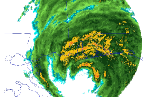
Figure 5. Doppler radar image of Hurricane Ivan just before the storm made landfall near Gulf Shores, AL, on Sept. 16, 2004. Click on the image for an animated loop.
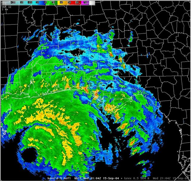
Figure 6. Eglin AFB (KEVX) Doppler radar image of Hurricane Ivan at 2104 UTC 15 September 2004. Click on the image for a larger view.
Intense outer rain bands from Ivan spawned numerous tornadoes over portions of the Florida Panhandle and Big Bend, as well as across southwest Georgia. The hardest hit counties were Bay, Calhoun and Jackson Counties, which accounted for six deaths and 16 injuries. There were also several touchdowns in Early Co., GA. Figure 6 (above) from the Eglin AFB (KEVX) doppler radar clearly shows the eye of the hurricane south of Mobile Bay as the first major outer band raked the Panhandle coast during the afternoon of September 15th. A train of tornadic storms can be seen lined up in the band. At the time of this image, a tornadic cell can be seen exiting western Bay Co., FL. A few minutes earlier, this cell produced an F2 tornado in Panama City Beach. The tornado struck the commercial area at Grand Lagoon, causing significant damage to a restaurant and real estate office. The tornado moved across the Hathaway Bridge and then 100 yards south of WJHG-TV, which captured the twister on film. This tornado killed a person in the restaurant and injured seven other people. The cell immediately to the east was also tornadic, destroying several homes in the Sandy Creek area of Parker, and killing one person. In this same image, cells that produced confirmed tornadoes are also present in Gulf Co., FL, and Early Co., GA.
Figure 7 (below) shows Ivan about five hours later. The same outer band that was raking the coast in Figure 6 can now be seen about 20-40 miles further to the north and east. At the time of this image, a tornadic cell can be seen crossing the Apalachicola River from Liberty Co., FL, into Calhoun Co. This cell produced an F2 tornado that cut a 5-mile swath of damage several hundred yards wide, five miles north of Blountstown. The tornado destroyed three mobile homes and damaged 20 frame homes, killing four people and injuring another. Within an hour of this image, the band spawned tornadoes in Holmes and Jackson Counties as well. In Jackson Co., the tornado destroyed 10 mobile homes in Marianna, and 25 mobile and 5-10 frame homes in Cypress. The high school stadium was damaged, as was a commerical building at the Marianna Municiple Airport. Fortunately, only four people were injured in the county, and there were no fatalities, due in large part to a mandatory evacuation that was in effect for all mobile home dwellers. All together, some 28 tornadoes were confirmed across the area, but it is likely that many more actually occurred during the storm. Schools were closed across the affected areas from as early as the 15th through the 17th. Additional information on Hurricane Ivan can be found here.
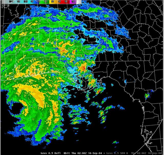
Figure 7. Eglin AFB (KEVX) Doppler radar image of Hurricane Ivan at 0206 UTC 16 September 2004. Click on the image for a larger view.
Jeanne
After suffering the affects, of Bonnie, Charley, Frances, and Ivan, the beleaguered state of Florida could not believe that yet another hurricane loomed. Hurricane Jeanne made landfall on the east coast of Florida near Stuart on the evening of September 25th, very near where Frances came ashore a mere three weeks earlier. Jeanne weakened to a tropical storm over central and northwest Florida on September 26th, and moved into South Central Georgia during the early morning hours of the 27th. Figure 8 (below) shows the storm as it crossed the state line. Maximum sustained winds reached 45 mph at Cross City, FL, with a peak gust of 62 mph. In Tallahassee, the peak gust was 48 mph. Valdosta, GA, reported a maximum sustained wind speed of 40 mph, with a peak gust of 52 mph. In northwest Florida, rainfall ranged from a half inch at Panama City to 7.60 inches at Mayo. In Georgia, rainfall ranged from just over an inch at Albany and Bainbridge to nearly nine inches at Tifton. Storm surge along the northeast Gulf coast ranged from two to four feet. Inland flooding was reported across eastern portions of the Florida Big Bend and over much of South Central GA. In Valdosta, GA, high water forced 700 residents of a subdivision to evacuate. Numerous county and dirt roads were washed out. There were widespread reports of downed trees and power lines. In Dixie Co., 215 homes were damaged and 18 were completely destroyed. Nearly 90,000 customers were without power in north Florida, with another 36,000 in GA. Schools were closed across the affected area on the 27th. School closings extended into the 28th in Lowndes and Dixie Counties. Additional information on Hurricane Jeanne can be found here.

Figure 8. Doppler radar image of Tropical Storm Jeanne as it passed east of the Florida Big Bend, on the evening of September 26, 2004. Click on the image for a larger view.
Very Warm Autumn
The area began transitioning to consistently above normal temperatures beginning in September, with the warm weather continuing through October, November, and the first couple weeks of December. In Tallahassee, October temperatures averaged over three degrees warmer than normal for the month. November was just over two degrees warmer than normal. Temperatures averaged above normal on 25 of the 31 days in October. No temperature records were set in Tallahassee during this period. However, Panama City tied or broke four daily maximum temperature records in October and one in November. Temperatures averaged nearly 7.5 degrees warmer than normal in PC during October, and nearly 6 degree above average in November. Only one day during the month averaged cooler than normal in Panama City. The first of three consecutive daily records was reached on October 2nd when the mercury reached 90, tying the record. On the 3rd and 4th, the highs of 92 and 91 each set new records. On the 21st, the high of 87 degrees tied the record for that date. On November 1st, the high of 85 also tied the daily record. Albany, GA, tied a daily record on the 3rd of November when the mercury reached 87 degrees. The last 80-degree temperature of the season occurred in Valdosta, GA, on December 9th.
Cold Temperatures Return in December with Some Holiday Sleet and Snow
As typically happens, winter came on quickly. The first light freeze of the season at the Tallahassee Regional Airport occurred on the morning of December 12th, when the temperature briefly dipped to 32 degrees. This first freeze occurrence was about five weeks overdue at the Tallahassee Regional Airport, which on average records its first freezing temperatures on November 6th. The first widespread freeze of the season occurred on December 15th. Inland areas had a hard freeze with lows in the mid 20s. Even coastal cities like Apalachicola and Panama City dipped a few degrees below freezing. Another hard freeze followed the next morning. After a short respite, another arctic outbreak gripped the area on the morning of the 20th. The coldest afternoon of the year occurred on Christmas Eve. Temperatures were in the mid 30s for most of the day, then rose slowly through the evening, peaking at 39 just before midnight. This is the coldest afternoon in Tallahassee since January 1999, and only the 5th time in the last 20 years that the mercury failed to reached 40 degrees for an entire calendar day. A very rare occurrence of holiday snow and sleet occurred this year as well. Several reports were received of sleet mixing in with a cold rain during the late morning hours of the 24th. Trace amounts of sleet were observed at Tallahassee, Dothan and Albany. On Christmas evening, rain briefly changed over to light snow for about 25 minutes at Panama City, and for about 10 minutes at Apalachicola. This is the first known occurrence of snow on Christmas Day at these two coastal cities. Snow flurries were observed mixing in with the rain here at the NWS office in Tallahassee on the night of the 25-26th. After a couple more freezes on the 27th and 28th, the final few days of the year saw a return to above normal temperatures. The average December temperature in Tallahassee was just 50.3 degrees, which was 3.4 degrees below normal.
Severe Weather
Typically, this part of the country sees a peak in severe weather activity during the spring months with a secondary maximum in November. Through summer, isolated severe storms are possible on almost any day, although large outbreaks are much less common. Occasionally severe weather occurs in the winter months, and some of these can be major outbreaks. In 2004, severe weather did not follow climatology. The peak spring severe weather season was less active than normal, due in large part to the total lack of severe weather in March. Severe weather was common during the summer with the biggest outbreak of the year occurring on July 15th. Tropical cyclones dominated the area during August and September. One small tornado outbreak occurred in late November, with a single severe weather episode in December as well. Monthly summaries of severe weather occurrences in 2004 can be obtained by clicking the links below.
Previous Years
Reviews of local weather in 2003, 2002, 2001 and 2000 are also available.
National Weather in 2004
An article summarizing last year's weather across the nation has been published by NOAA. A more detailed summary has been posted by NCDC. Also included in this site is a collection of significant weather events that occurred nationally last year.


 Follow us on YouTube