
Scattered severe thunderstorms are possible today across central and eastern Minnesota, Iowa, and western Wisconsin. A few tornadoes, isolated very large hail, and damaging winds may occur. An upper level low will help trigger scattered thunderstorms over portions of central and southern California today along with a few inches of snow in the central Sierra Nevadas. Read More >
|
THE 1966 TOPEKA TORNADO
|
|
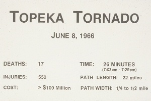
June 8th marks the 56th anniversary of one of the most destructive and deadly tornadoes in Kansas history. The massive 1966 Topeka tornado killed 17 people, injured over 500 and caused over $200 million damage; at the time, the highest in America history. With modern day inflation factored in, the tornado still ranks as one of the costliest on record estimated near 1.8 Billion dollars (in 2015 dollars).
The Path
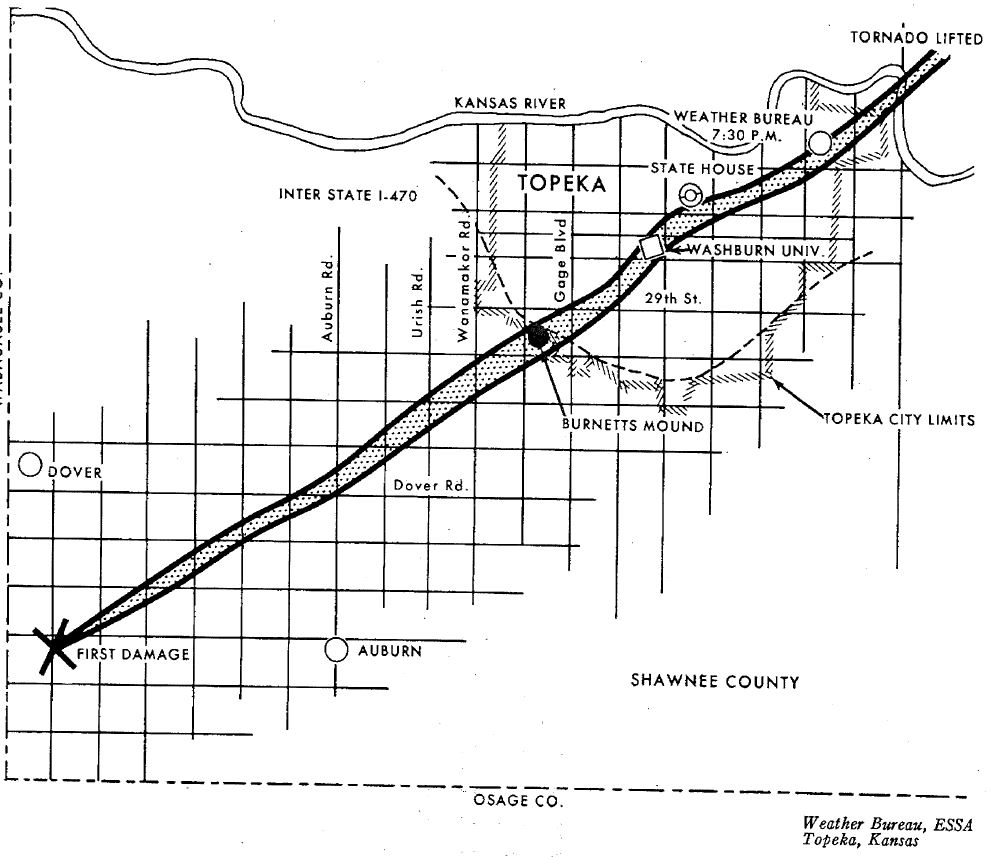
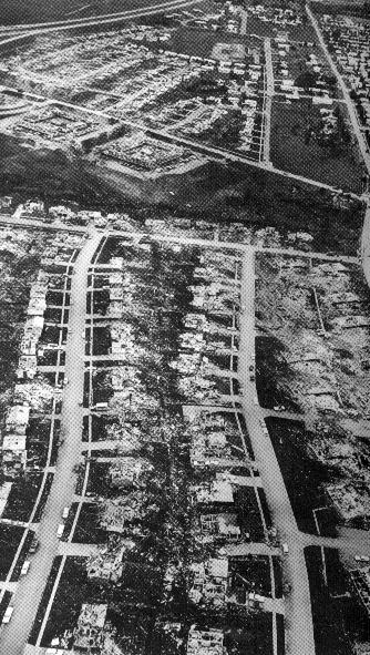
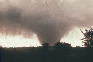
The tornado formed about 7pm west of Auburn in southwest Shawnee county, and cut a 22 mile long path, at times a half a mile wide, across the heart of the city. Total devastation occurred along an 8 block section in the center of Topeka. Every building on the Washburn University campus was either destroyed or heavily damaged producing $10 million damage, alone. Citywide about 800 homes were completely destroyed with nearly 3000 damaged. Even the state Capitol dome sustained damage from the flying debris, as did many downtown buildings. The intense destruction classified the tornado as an F5, the top of the Fujita Intensity Scale, with winds estimated at over 250 mph.
 |
 |
| The tornado held a northeast pace at about 35 mph, but weakened after leaving the downtown area, finally dissipating just east Billard Airport on the city's northeast side after being on the ground for about a half an hour. Power and utilities in many parts of the city were out for weeks, and hundreds were left homeless.
Entering the southwest part of Topeka, the tornado roared across Burnetts Mound, ending a longstanding Indian legend that the Mound would deflect any tornadoes and spare the city. |
 |
| Watches and Warnings Excellent watch, warning and storm spotter activation prior to the storms development helped keep the death and injury toll relatively low, especially when compared to the amount of destruction and the storms path. In addition, the existence of an active and longstanding community preparedness plan and underground sheltering options likely also proved instrumental in reducing potential casualties and injuries. Outstanding education, cooperation and understanding between Topeka governmental agencies, the media and public became a model for other cities to follow in the future. |
 |
Research and examination of the destruction and debris provided insights into tornado understanding, and improved safety rules and information. For example, the longstanding advice about going to the southwest corner of the basement and opening windows, was shown to be incorrect from damage surveys in Topeka. We now know that you should forget the windows, and head for the basement and get under a table, stairway or something sturdy to protect yourself from blowing and falling debris. Remember to get to the lowest floor of a home or building and to get as many walls between you and the outside as possible.
Often overshadowed by the Topeka destruction, a large tornado also hit the city of Manhattan on June 8th causing 65 injuries and about $2 million damage. The Manhattan tornado hit shortly before 6pm on the city's northwest edge, destroying 11 homes and damaging over 300 more. Public awareness of the Manhattan tornado, likely alerted Topeka residents to volatile atmospheric conditions and high potential for another tornado. In addition, shortly after the Topeka tornado, and likely from the same thunderstorm, two other tornadoes occurred in Leavenworth county, producing one fatality near Jarbalo.
|
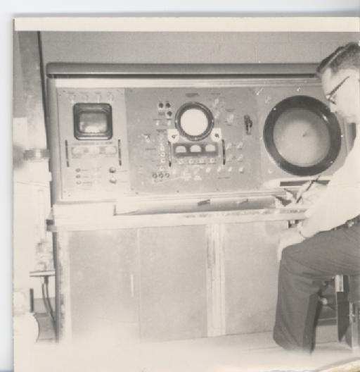
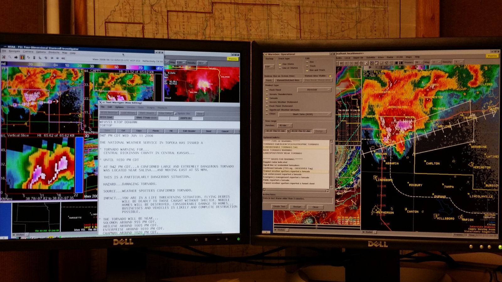
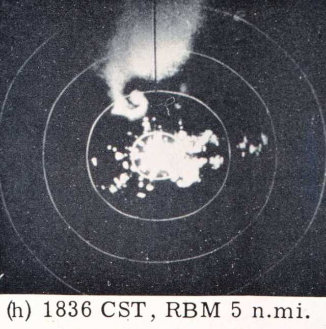
A lot has changed since 1966, including weather technology that lets us better understand, forecast and warn for deadly tornadoes, like the one that devastated Topeka. Powerful supercomputers, have allowed quick and thoroughly analysis and prediction of weather data. Small scale weather features unknown in 1966, are now scrutinized routinely for atmospheric evidence and clues. Computers have also been coupled to more powerful and sophisticated Doppler weather radars, to look inside thunderstorms for areas of rotation, which are sometimes a precursor to the tornado. Weather radars used in 1966 were WWII surplus with small fuzzy black and white images, like the one pictured below from the 1960 Meriden tornado. Today's National Weather Service Doppler radar present state-of-the-art high detail color images of both reflectivity and velocity zoomed to city and county level. Additional 3D interrogation of storms can pinpoint critical areas for storm spotters to observe before tornado development. Much smaller warning areas are now selected on the radar screen using a cursor and movement vectors. With another click of the mouse the complete warning text is generated in seconds, and disseminated immediately, a fraction of the time it took to hand type a warning in 1966. |
 |
 |
 |
Slow speed manual teletypes and paper facsimile charts have been replaced by ultra high speed satellite computer driven communication circuits. These modern tools can bring weather information and send warnings out to the media and public in a fraction of a second. Direct broadcasts to the public by the NOAA Weather Radio network allow the average citizen to receive warning information anytime day or night, and at the same time as media outlets. The explosion of the internet and use of mobile devices has allowed a multitude of weather data and alerts to be available to nearly everyone especially through the use of social media.
Can the devastation of June 8, 1966, happen again? Sadly 2011 proved that it can as violent tornadoes hit population centers and caused over 550 fatalities across the country. We can't stop storms from forming but we can provide the best warning services possible given the state of science and our technology which has allowed for warnings to be provided with greater lead time than ever especially for strong and violent tornadoes. However we also need to continue to improve communications with those at risk and to continue to look at improving the sheltering options of those who have no underground shelters.
All Photographs Appear Courtesy of the Topeka Capitol Journal
 |
 |
 |
 |
 |
 |
 |
 |


