Local and Regional Events:
September 4, 2001:
Near record or record heat hit central and north-central South Dakota on this day in 2001. High temperatures during the afternoon were in the upper 90s to around 105 degrees. Pierre and Kennebec set record highs of 105 and 106, respectively. Mobridge rose to a high of 96, and Timber Lake topped out at 98 degrees on this day in 2001.
U.S.A and Global Events for September 4th:
1766: A hurricane made landfall at modern-day Galveston, Texas. The following is from David Roth of the Weather Prediction Center. “A mission, named San Augustine de Ahumado was located in what is nowadays known as Chambers County. This mission was destroyed and subsequently abandoned. A seven-foot storm surge put the area under water. A richly-laden treasure fleet of 5 galleons en route from Vera Cruz to Havana was driven ashore and had to wait many weeks for assistance to come. La Caraqueña wrecked on Galveston Island while El Nuevo de Constante sank along the western Louisiana coast. Fortunately, much of the treasure and people aboard were saved.”
1941: A violent tornado ripped through Northeast and North Minneapolis shortly afternoon on this day. The hardest-hit location was the Soo Line Railroad’s Shoreham Yards where four people died, and at least 50 were injured. The death toll at Soo Line could have been higher, but the tornado struck five minutes after the lunch bell went off, meaning 100 men left the shops. Click HERE for photos from Historic Minneapolis.
2000: Houston and College Station, Texas recorded their hottest day on record when highs reached 109° and 112° respectively. Houston has tied their record on August 27th, 2011. Other daily record highs included: Wichita Falls, TX: 111°, Waco, TX: 111°, Dallas, (DFW), TX: 111°, Austin, (Bergstrom), TX: 110°, Austin (Camp Mabry), TX: 110°, Dallas, TX: 110°, Victoria, TX: 110°, San Antonio, TX: 109°, Shreveport, LA: 108°, Corpus Christi, TX: 107 °F.
2007: Hurricane Felix came ashore in the pre-dawn hours as a Category 5 storm on the northeastern coast of Nicaragua. At the time of its landfall, the maximum sustained surface winds were approximately 160 mph. Felix killed at least 130 people along the coast, with damage in Nicaragua totaling $46.7 million. Click HERE for more information from NASA's Earth Observatory.
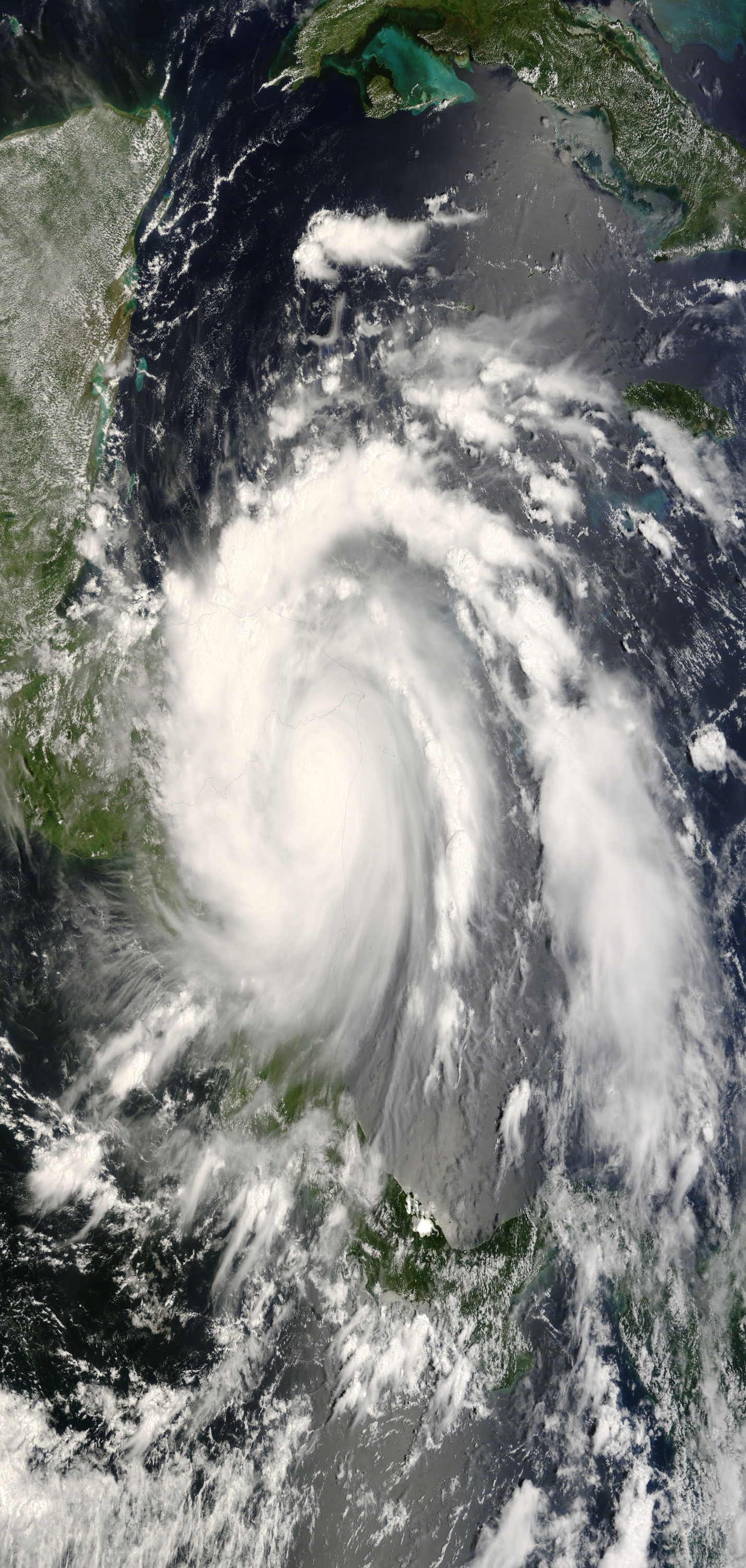
The Moderate Resolution Imaging Spectroradiometer (MODIS) on NASA’s Terra satellite captured this image of Hurricane Felix at 10:10 a.m. local time (16:10 UTC) on September 4, 2007. At that time, Felix had slammed into the mountains of Nicaragua inland and lost enough power to be rated a Category 3 status hurricane with sustained wind speeds of 120 mph. The NASA image is by Jeff Schmaltz, MODIS Rapid Response Team, Goddard Space Flight Center.
2011: The center of Tropical Storm Lee moved ashore around sunrise. However, it would be a while before Lee would weaken to a depression as it remained nearly stationary while the southern half of the circulation was over water where it could continue to derive additional energy from the warm ocean. Lee brought torrential rains to Louisiana, Mississippi, and Alabama. Click HERE for more information for the NWS Office in Mobile, Alabama.
2016: An EF1 tornado developed in the open country area north of Merna, Wyoming. The tornado caused tree damage along its 2.45-mile path. At its widest, the tornado produced sporadic tree damage approximately 300 yards across. The trees fell on some fence line but otherwise caused no property damage. Click HERE for more information from the NWS Office in Riverton, Wyoming.
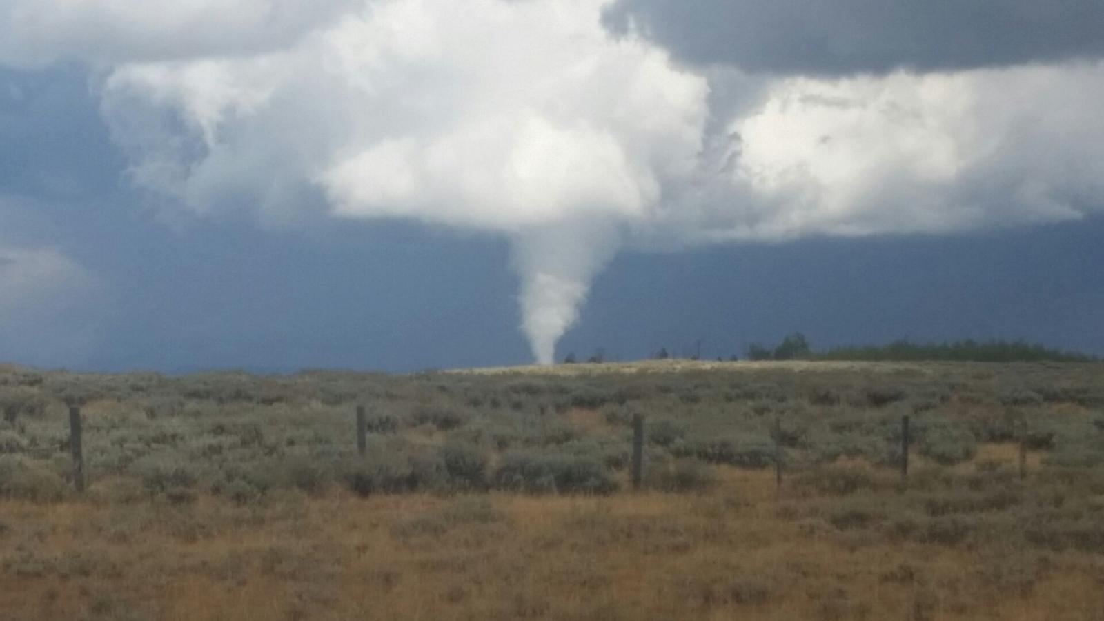
Sublette County Tornado as seen from north of Merna, Wyoming, looking northeast around 12:50 pm MDT Sunday, September 4, 2016. (Photo Courtesy of Randy Foster)
Click HERE for more This Day in Weather History from the Southeast Regional Climate Center.

