Anchorage, AK
Weather Forecast Office
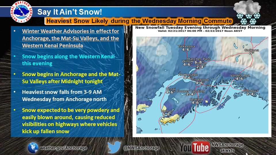
Say it ain't snow!
Locally heavy snow causing roads to become slick and reduced visibilities expected for the Wednesday morning commute.
A front pushing northeastward across the area will be the catalyst for the next round of snow across Southcentral.
Timing:
Kenai Peninsula:
9pm-Midnight Tonight: Snow begins along the southern Kenai Peninsula early, spreading north and increasing in intensity. 1-2 inches south, up to 1 inch north.
Midnight-6am Wednesday: Moderate Snow, locally heavy at times- 3-5 inches of new snow accumulation, highest amounts south towards Homer.
6am-9am: Snow rapidly diminishes with improving conditions from south to north- Up to 1" of new snow accumulation.
Anchorage and the Mat-Su Valleys:
9pm-Midnight Tonight: Flurries and Light Snow Showers- Minor accumulation possible
Midnight-3am Wednesday: Light Snow, increasing in intensity. Up to 1 inch accumulation
3am-9am: Moderate Snow, locally heavy at times
3-5 inches of new snow accumulation
9am-Noon: Snow rapidly diminishes with improving conditions. New snow accumulations of up to 1"
US Dept of Commerce
National Oceanic and Atmospheric Administration
National Weather Service
Anchorage, AK
6930 Sand Lake Road
Anchorage, AK 99502
907-266-5105
Comments? Questions? Please Contact Us.

