Highest flood ever recorded in Albany, 21.71 feet, caused by ice jammed on the sandbars south of the city.
Major flooding in the Northeast. Highest water on record for the Hudson River from Hadley and Glens Falls south to and including Troy. Stages of 29.7 feet on the Hudson River at Troy, 21.45 feet on the Hudson River at Albany, 228.9 feet on the Mohawk River at Schenectady, and around 19 feet on the Mohawk River at Little Falls.
Flood of Record at Schenectady, 232.9 feet, water reached Broadway and flooded the former American Locomotive Plant on Maxon Road. Caused by an ice jam.
Disastrous flooding in New England with devastation over the northern 2/3 of Vermont. Floods of record for White, Winooski, Lamoille, Missisquoi rivers and Otter Creek. Flood of record for Batten Kill, 17.7 feet, and major flood for Hoosic River, 18.8 feet, also caused a significant flood on the Hudson River at Albany, 15.96 feet. Flooding was the result of rains from the remains of a late season hurricane.
Major flooding throughout the Northeast as a result of extremely heavy snowpack and a double dose of spring rains. Caused highest stages on Hudson River at Troy, 29.5 feet and Albany, 17.9 feet, since completion of Conklingville Dam. Flood of Record on Connecticut River at Thompsonville Connectciut; just north of Hartford.
One of the most destructive and powerful storms ever to strike Long Island and southern New England. Severe flooding occurred across almost all of the region's rivers. Most severe across New England. The Hudson River at Albany reached 16.5 feet.
Severe flood in upper Mohawk area including record flood on East Canada Creek at Dolgeville, 15.1 feet. Record flow on West Canada Creek at Kast Bridge, 8 feet, nearly destroyed the Daniel Greene Factory in Dolgeville.
Major flooding occurred in the Hudson, Housatonic and Connecticut River drainages as a slow moving storm brought heavy rain. Liquid equivalent precipitation (mostly rain) was 5-12 inches across these river basins. Rainfall was heaviest December 29 into December 31. Snowmelt and ground frost were limited due to unseasonably warm temperatures during the late fall and early winter. Precipitation changed to snow at the tail end of the storm. Major flooding along the Hudson River at Albany. The famed New Years ice storm and flood which caused the flood of record on the Hoosic River at Kinderhook along with other streams. 17.5 feet crest in Albany. Involved a significant sleet storm as well as rain. Major flooding occurred in the Hudson, Housatonic and Connecticut River drainages as a slow moving storm brought heavy rain. Liquid equivalent precipitation (mostly rain) was 5-12 inches across these river basins. Rainfall was heaviest December 29 into December 31. Snowmelt and ground frost were limited due to unseasonably warm temperatures during the late fall and early winter. Precipitation changed to snow at the tail end of the storm. A flood of record occurred on the Hoosic River at Kinderhook with major flooding along the Hudson River at Albany with a crest of 17.5 feet on January 1st).
Back to back hurricanes, Connie and Diane made landfall on the coast of North Carolina only 5 days apart, significantly impacting southern New England. Hurricane force wind and storm surge caused only minor damages, but rainfall created devastating impacts. Significant rainfall amounts from Connie set the stage for the devastating floods caused by the rainfall from Diane. Connie dumped over 10 inches of rain at Slide Mountain in the Catskills of New York brought the Esopus Creek only up to 12 feet. Five days later, on August 17th, Hurricane Diane came right into the Hudson River Valley, which resulted in the worst flood disaster in the Lower Hudson Valley of New York and in the State of Connecticut. Diane dropped over 19 inches of rain at Westfield MA. Floods of record on the Housatonic River at Gaylordsville, 18.6 feet, Stevenson, 24.5 feet, Shepaug, 17 feet, and Tenmile River, as well as Rondout and Wappingers Creek. The Village of Ellenville was nearly washed off the map, while the riverfront in Kingston was under nearly 4 feet of water. Eight states were declared federal disaster areas. Known as the $1 billion hurricane (1955 dollars), Diane caused record flooding in the Lower Hudson Valley of New York and in the State of Connecticut, including along the Housatonic, Mad, Naugatuck and Farmington rivers.
Severe flooding on the Schoharie Creek caused by a slow-moving coastal storm with produced 16 to 18 inches of rainfall over the Tannersville area and devastation in the Schoharie Valley (Burtonsville 12.4 feet, second highest of record).
Agnes made secondary landfall near New York City as a strong tropical storm then merged with a low pressure system resulting in heavy rains. Flooding that began in Westchester County on June 19, was followed by widespread flooding in the Southern Tier and Finger Lakes on June 23. This was a devastating flood event in Elmira and Corning, NY. This storm produced widespread heavy rains of 6 to 12 inches across Pennsylvania and western New York. Although more than 10 inches of rain was recorded at Slide Mountain, NY, flooding along the Esopus Creek was relatively minor. At Great Sacandaga Lake, the water level reached a record height for the 42-year history of the lake.
Hurricane Eloise, caused significant flooding on the Susquehanna River and in parts of Catskills.
Worst regional flood across the area since the New Years Flood nearly 30 years earlier. An early warm spell with temperatures into the 70s and 80s, combined with a heavy snowpack, and 3 inches of rain produced a record flood on the Mohawk River at Little Falls and near record flood on Kaydeross in the Saratoga area. Ice jams caused flooding along many small creeks and along the Connecticut River in Windham County, VT. The Pontoosuc Dam in Pittsfield, MA was threatened by overtopping but held. Ramps to new Interstate 787 in downtown Albany were flooded, and the current in the Hudson River undermined the Green Island Bridge causing it to collapse into the river on March 15 around 2:30 PM with, miraculously, no fatalities or injuries.
Severe ice jam in Prattsville NY effectively blocked the streamflow from the full reservoir. Widespread flooding in the region with an entire herd of dairy cattle drowned in their barn.
Severe ice jamming caused flooding of many rivers including the Hudson, Mohawk, Susquehanna, and Chenango Rivers, as well as the Schoharie Creek.
Severe flash flood on the Boquet and the Branch in and near Elizabethtown. Numerous washouts on the road between Elizabethtown and Keene caused the deaths of four Olympic Bobsled hopefuls.
The "Great Catskill Toilet Flush" with around 10 inches of rain on nearly bare and frozen ground which led to rapidly developing and severe floods on Schoharie, Catskill, and Esopus Creeks. A fatality occurred when a motorist ignored a roadblock.
Severe ice jamming on Mohawk River which nearly flooded the New York State Thruway (I-90) near Fonda.
"Spring Monsoon" with over 18 inches of rain over two months in Ellenville and New York City. Sacandaga Reservoir spilled over on May 1st for the first time since the project was completed in 1930.
Snowmelt and large rainfall amounts on March 31st and April 4th-7th led to flooding from eastern Pennsylvania and New Jersey, northeast across eastern New York into much of New England. Severe flooding occur on the Mohawk River and in the Catskills. Damage from flooding was widespread in this area and led to numerous evacuations. 500 people were evacuated from their homes in the Berkshires in western Massachusetts. In New Milford, CT, the Housatonic River ravaged through town damaging many roads. In Vermont, Corp of Engineers reservoirs spilled for the first time in their history. On the morning of April 5, the New York State Thruway Bridge over the Schoharie Creek suddenly collapsed. At least 10 people died when their vehicles plunged into the flood swollen creek.
Severe Ice jam on the Ausable East Branch with much of Ausable Forks village under water.
The Northeast Floods of January 1996 were the result of a very rapid snowmelt punctuated by a short but intense rainfall; 2 to 4 inches of rain. What made this event so unusual was the nature and the intensity of the snowmelt, combined with the intense rainfall for this time of year, over such a large geographical area. The flooding was compounded by ice movement and jamming in many of the rivers and streams. The floods were described by some as a "flash flood" for main-stem rivers due to the unprecedented rates of rise recorded during this event. Record flooding on Schoharie Creek and significant floods on Mohawk River at Schenectady, and on the Hudson at Albany (15.5 feet; greatest since New Years 1949).
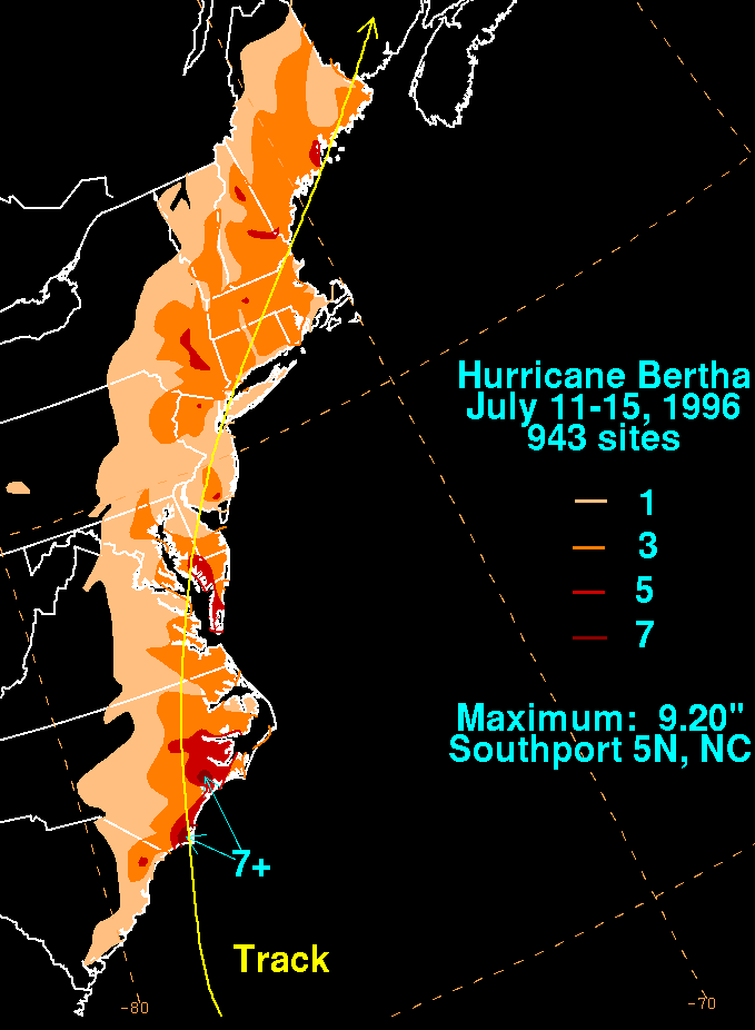
Hurricane Bertha was an early season Category 2 storm when it made landfall on the coast of North Carolina on July 12, 1996. The storm continued up the east coast into southeast New England. Heavy rains of 5 to 7 inches were reported in the Lower to Mid Hudson Valley and in the Catskills. Due to heavy precipitation flash flooding occurred in Columbia and Dutchess counties causing states of emergency. In Albany County several roads and small streams were flooded. The Normans Kill Creek spilled over its banks. Flooding was most widespread in the Towns of Bethlehem, New Scotland and Rensselaerville. High winds contributed to scattered power outages across Eastern New York State. Across Berkshire (MA) and Litchfield (CT) counties rain totals ranged from 3 to 5 inches and minor river flooding occurred across the area.
A catastrophic ice storm and flood event struck northern New England and northern New York during the first two week of January 1998. Heavy rain associated with a warm moist air mass overspread a shallow but dense layer of cold air producing ice accumulations in excess of 3 inches. Heavy rainfall, exceeding 4 inches in some areas, combined with significant runoff from melting snowpack to produce record flooding. National Weather Service Service Assessment.
Tropical Storm Floyd dumped very heavy rains, 3 to almost 12 inches, across the region. National Hurricane Center - Tropical Cyclone Report.
The remnants of Hurricane Ivan dumped dumped heavy rains across the region, up to 6 inches in some locales.
In mid January warm, breezy conditions combined with high dew points melted most of the snow across the area. Runoff from the melt combined with runoff from heavy rains to cause some flooding and flash flooding. The stage below Stevenson Dam on the Housatonic was the highest since 1960. The stage on the Wappingers Creek at Wappingers Falls was the highest since 1987.
Combination of high pre-storm flows, rain plus snowmelt. A slow moving storm moved up through the Appalachians and into the Northeast, producing an extended period rainfall on April 2-4th. The heaviest rain and worst flooding occurred in Ulster and Greene Counties. Upslope flow enhanced rainfall amounts in the Catskills, where generally 3 to 6 inches fell. Flood of record occurred on the Esopus Creek (Mount Marion 26.24 feet). U.S.G.S. estimated it as 100 year event for the Upper Hudson Basin. Sacandaga Lake and Indian lake were nearly empty and were able to cut half the peak flow off the Hudson. As a result moderate as opposed to devastating flooding resulted on the Hudson River.
Thunderstorms moving from west to east repeatedly affected the same areas of central Warren County between about 6 pm and 9 pm with over 6 inches of rain fell at Bolton Landing. Flash flooding which washed out a portion of the Northway between Exit 23 and 24.
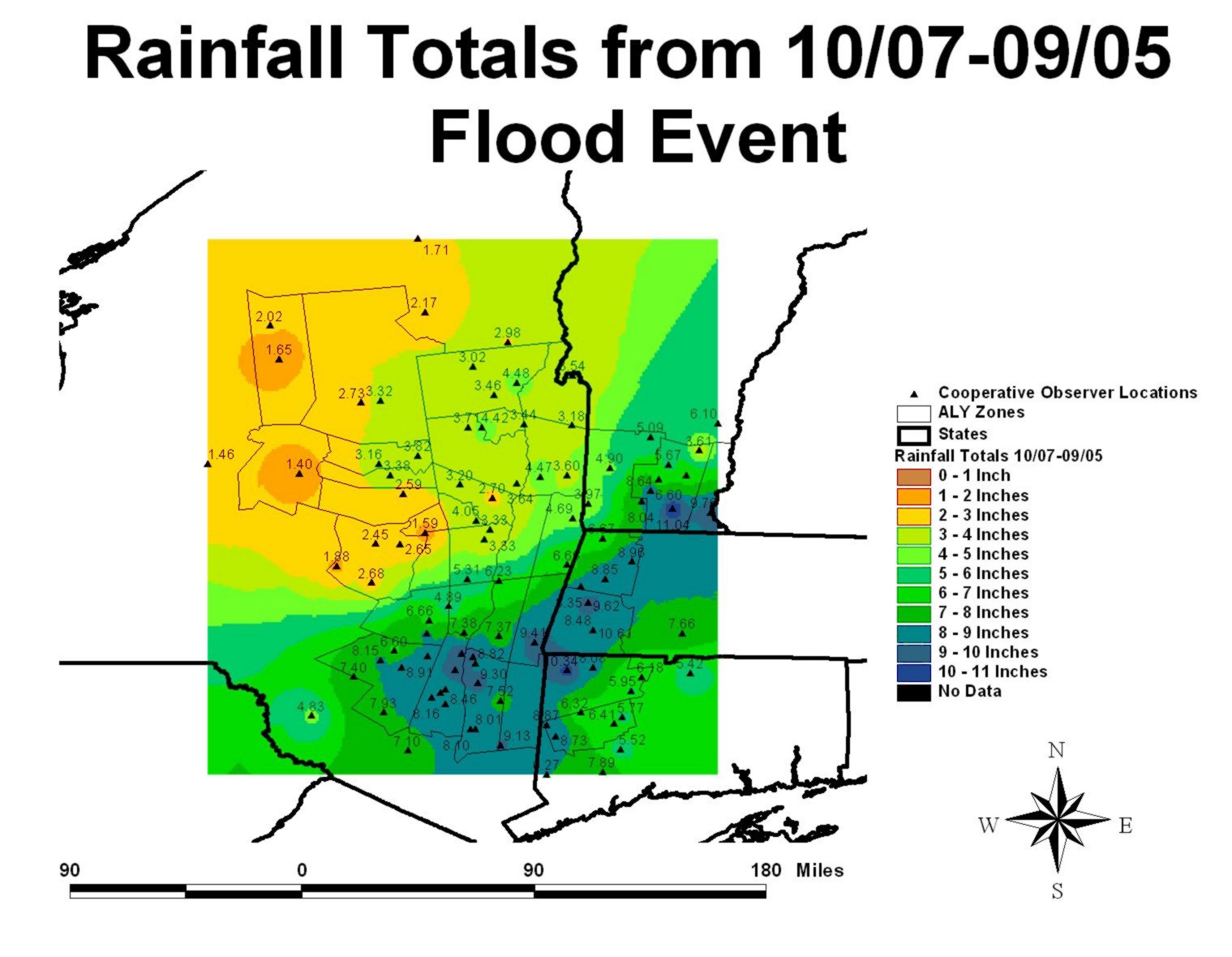
According to the Drought Monitor of September 27th, 2005, the southern part of the Albany Hydrologic Service Area was in a moderate drought. This changed dramatically in October 2005 as two rain events dumped a total 1 to 2 feet of rain across the driest areas. The first event, October 7-9th, the remnants of Tropical Storm Tammy interacted with a cold front; then a stationary low pressure sat south of Long Island and brought periods of heavy rain to New York and New England the 12th through 14th. The worst flooding occurred in Dutchess County, New York and Litchfield County, Connecticut where moderate to major flooding was reported.
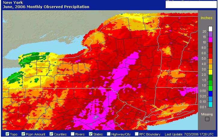
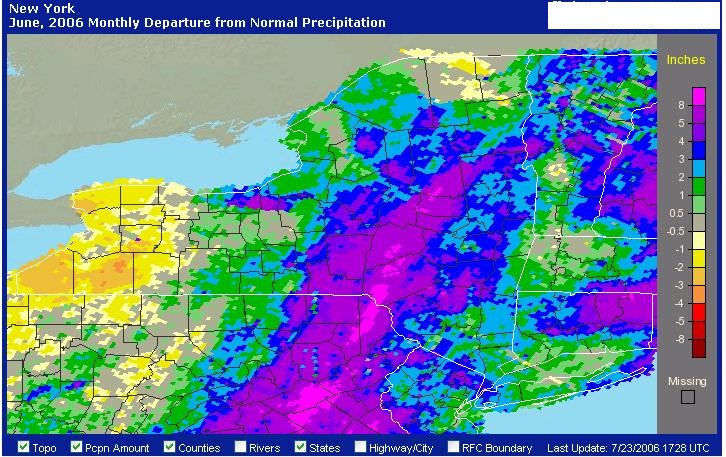
Widespread flooding in the Mohawk and Hudson river basins and eastern Catskills was occurred. Flooding was most severe along the Mohawk River and its tributaries. On Tuesday, June 27th, a frontal boundary stalled across the region. The boundary extended from southern Quebec across central New York and to Florida. A weak disturbance, tropical in origin, moved along the boundary across southeast New York Wednesday morning, June 28th. A strong low level jet also developed which transported more tropical moisture into central and eastern New York. Rainfall amounts from June 26th through the 30th ranged from as little as around an inch up to around a foot in the eastern Catskills. Departures from normal for June 2006.
An intense and powerful storm brought flooding rains and a heavy wet snowfall to the region. Rainfall amounts of 6 to 8 inches were reported across the eastern Catskills, mid Hudson Valley and western New England resulting in widespread flooding. Snowfall accumulations of 1 to 1 1/2 feet were reported across the southern Adirondacks, eastern Catskills, Berkshires and southern Green Mountains with resulting power outages.
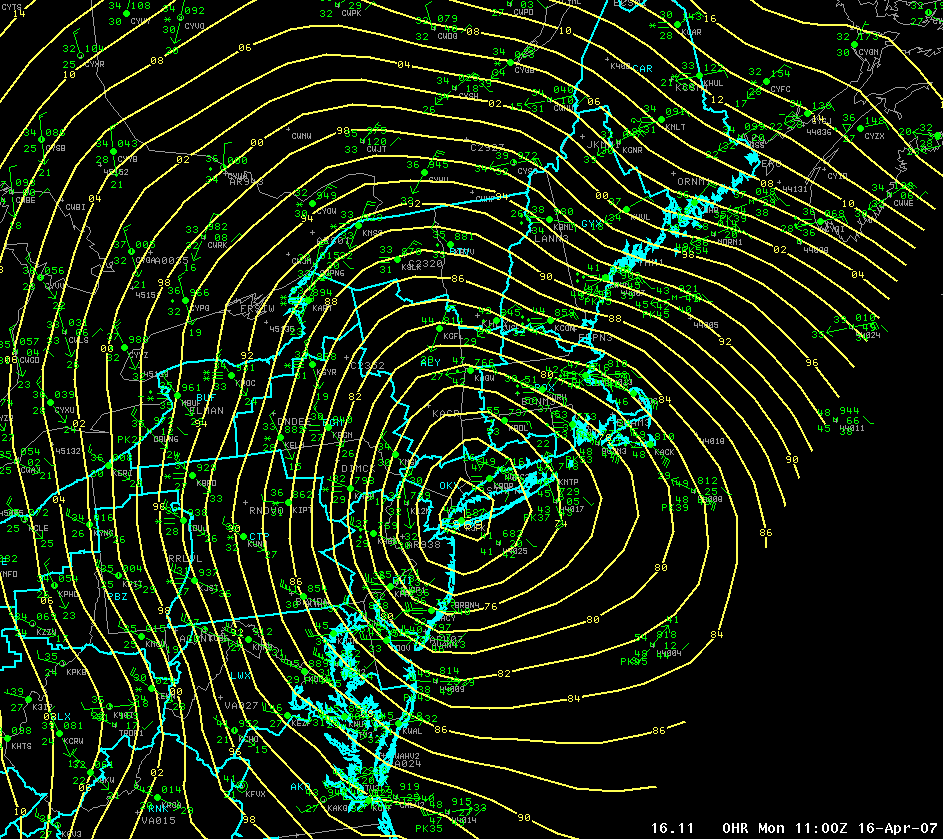
Low pressure system developed over the deep south by Friday morning, April 13th. The low pressure system then track eastward across the southeastern United States early in the weekend. By Sunday morning, the low center was over the Carolina and precipitation had spread northward across the local area. The storm rapidly intensified as it headed northeast into the mid Atlantic Region Sunday, April 15th. The storm was a its deepest around sunrise Monday, April 17th, with a surface pressure of 28.61 inches (969 millibars) over Nassau County (Long Island) New York. The low moved little throughout the day Monday and finally began to drift southeastward Monday night.
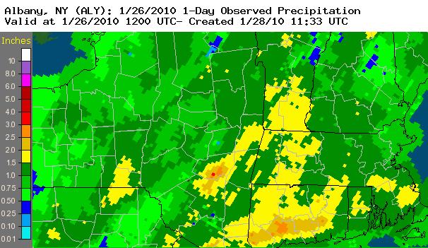
Flooding occurred across East Central New York and adjacent western New England on January 25th and 26th from a combination of rainfall and snowmelt. Rain was heaviest in the Catskill Mountains where 3 to 5 inches of rain fell. Elsewhere, just under 1 to around 2 inches of rain was reported. There was some snow melt, but the mountains did not lose their snow cover. Flash flooding also occurred due to heavy rain on frozen ground. In addition, some ice jam flooding was reported. Some mud and rock slides were also reported. River flooding was widespread and ranged from minor to moderate. Significant ice jam flooding was reported on January 26th in the Town of Dolgeville, NY along the East Canada Creek (Herkimer and Fulton Counties) and in Rotterdam Junction, NY and Scotia, NY along the Mohawk River in Schenectady County. Minor ice jam flooding was reported along the Mohawk River in Schenectady, NY. Also, minor tidal flooding occurred along the Hudson River in the vicinity of Poughkeepsie, NY.
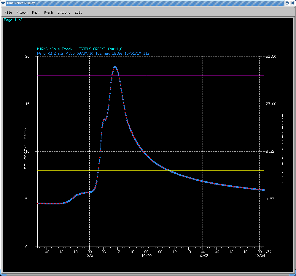
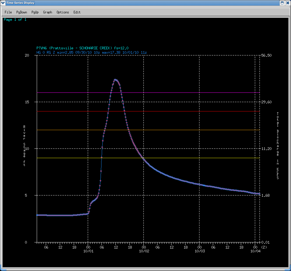
The remnants of Tropical Storm Nicole moved northward along a nearly stationary boundary along the east coast bringing abundant tropical moisture into the region. A very strong low level jet help fuel the heavy rainfall which lead to widespread flooding and produced strong gusty southerly winds with resulted in damage to trees and power lines. Rainfall reports ranged from just over 3 inches up to 9 inches across east central New York and adjacent western New England. At the Albany International Airport daily rainfall records were set for September 30th and October 1st. Widespread urban and small stream flooding was reported. Major flooding occurred on the Esopus Creek at Cold Brook and on the Schoharie Creek at Prattsville with widespread minor river flooding occurring along portions of the Esopus Creek, Rondout Creek, Schoharie Creek, Mohawk River, West Canada Creek, Hudson River, Sacandaga River and Still River.
Prior to this rainfall deficits were running around 6 to 9 inches across east central New York and western New England. There were moderate drought conditions across southern Vermont, the Berkshires and northwestern Connecticut into the Taconics of New York with abnormally dry conditions across much of east central New York. Drought conditions eased after the event.
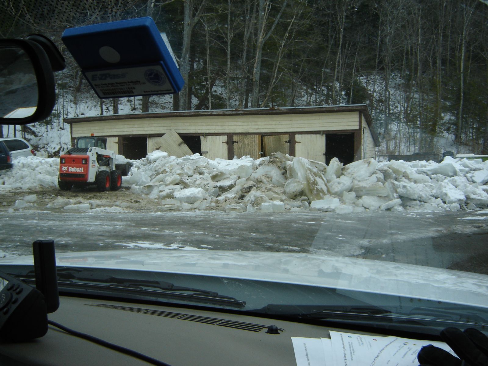
The combination of the heavy rainfall and runoff from the snowmelt due to mild temperatures caused flooding of rivers, streams, creeks, roads, and some urban low lying areas. Moderate flooding occurred along the Esopus and Schoharie Creeks. Generally 1 to 3 inches fell with locally higher amounts of 4 to 5 1/2 inches reported across portions of the eastern Catskills. An ice jam formed on the Mohawk River which resulted in flooding along the river in parts of Albany, Saratoga and Schenectady counties. The combination of increased flow from the upper Mohawk Basin and out of the Schoharie Creek due to runoff from the heavy rainfall and snowmelt caused ice to move. On Friday, March 11th, an ice jam in place in Schenectady County at Lock 9 and Lock 8 broke up and moved downstream. Another ice jam formed and extended from the Twin Bridges back towards Lock 7 in Niskayuna and caused flooding of some properties and houses along the river. The ice jam broke up and moved down river without any additional flooding on Sunday, March 13th.
Record flooding occurred on the Hudson River at North Creek as a result of an ice jam. The ice jam extended from about 1 1/2 miles downriver from the Route 28N Bridge and northward about 3 miles. An ice jam began to form on Monday, March 7th, near the Route 28N Bridge in North Creek after heavy rainfall and snowmelt. Water backed up from the ice jam began flooding Old River Road early Thursday morning, March 10th, prompting the evacuation of some residents and the closure of the road. The water began to recede early Sunday afternoon, March 13th, when the ice jam released and moved downstream. The ice jam moved down river and ripped trees from the river bank. The jam became lodged along the Route 418 Bridge in the town of Thurman Sunday evening, March 13th, with water levels receding behind the jam.
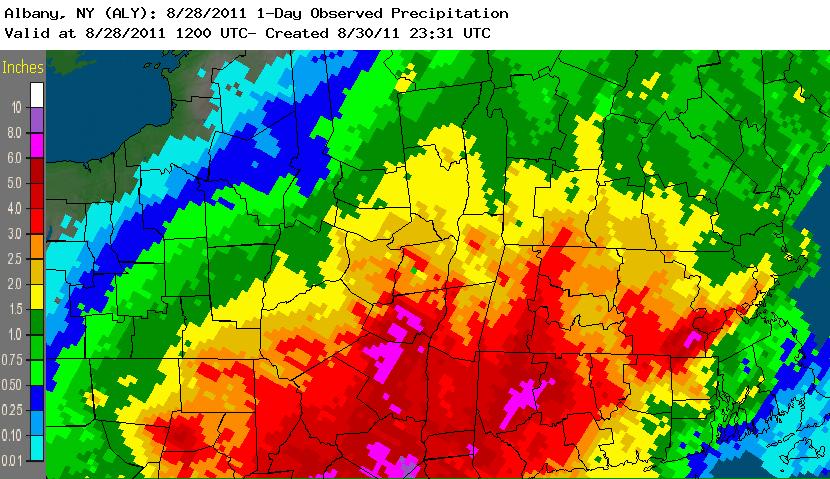
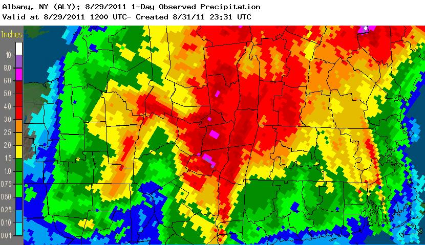
The storm made tertiary landfall near New York City and moved north northeast over Vermont. It produced widespread, devastating flooding in Vermont, New Hampshire, New York, and New Jersey. The observed sudden and tremendous increases in river stages in a 2–3 hour timeframe were more characteristic of flash flooding in small streams than expected behavior from main stem rivers. A rainfall maximum of over 18 inches was recorded in the Catskills. In addition to the widespread and significant flooding, tropical storm force winds took down many trees and resulted in nearly one million people without power, some for up to a week. Several towns in Vermont and in the Catskill Mountains in southeast New York were entirely isolated and eventually received airlifted disaster supplies until roadways were made passable again. Interstate 88 in New York was closed from Exit 22 to 24 from 28 August 2011 through 31 August 2011 due to flooding concerns, including evaluation of a bridge affected by high water (later deemed to be safe). Portions of Interstate 87 southbound (New York State Thruway) were closed on 28 August 2011 for flooding as well as for downed trees and power lines.
Heavy to extreme rainfall resulted catastrophic flooding. Rainfall amounts were generally 4 to 12 inches with locally up to 18 inches. Maps of 24-hour precipitation ending at 8 am on: August 28th & August 29th. Peak River Crest USGS gages. Peak Wind Gusts. Local Storm Reports. Post Tropical Cyclone Report. National Hurricane Center - Tropical Cyclone Rerport. NWS: Service Assessment Hurricane Irene August 21-30, 2011
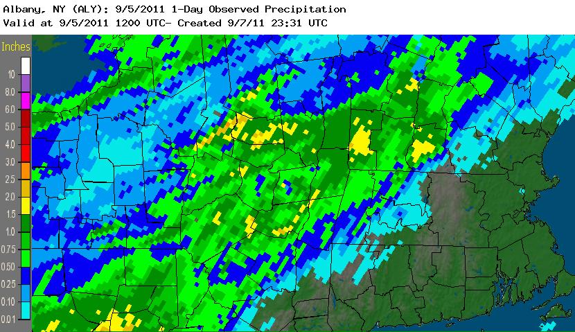
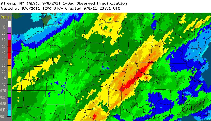
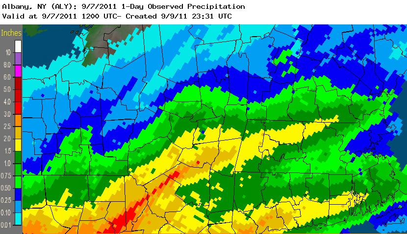
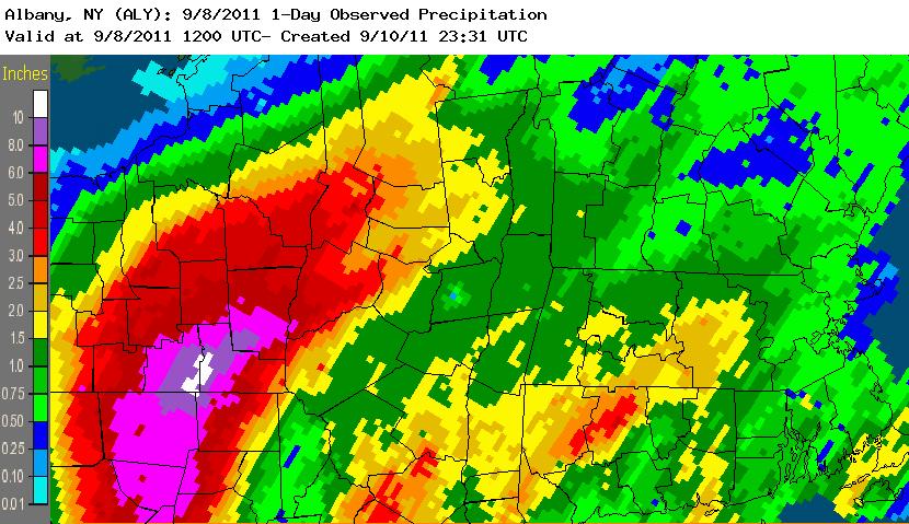
Heavy rainfall, combined with saturated soil from the excessive rains which fell in late August associated with the passage of Irene, led to widespread minor to moderate flooding on rivers, as well as small streams and creeks across eastern New York and adjacent western New England. Rainfall amounts of just over 2 inches to 9 inches occurred. Some major flooding did occur across portions of the western Mohawk River. In addition, flash flooding occurred across portions of the eastern Catskills and western Mohawk River Valley. Maps of 24-hour precipitation ending at 8 am on: September 5th, September 6th, September 7th, and September 8th. National Hurricane Center - Tropical Cyclone Report.
On June 14th, showers and thunderstorms moved (trained) over areas that had received significant rainfall over the past several weeks from convection. Flash flooding occurred with the town of Middleburgh in Schoharie County the hardest hit as small creeks and tributaries (surprisingly not the Schoharie Creek itself) (combined with elevation influences) resulted in much of the town experiencing flash flooding. Flash flooding was also reported in Sharon Springs, Schoharie, Richmondville, and Cobleskill. A group of elementary students at a school in Middleburgh were sheltered in place during the flooding, since there was no way to get into Middleburgh during the height of the flooding.
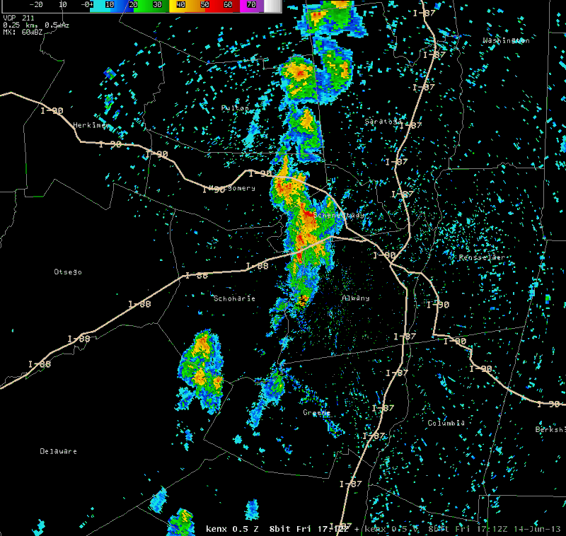
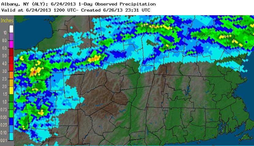
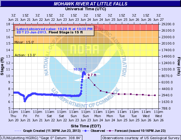
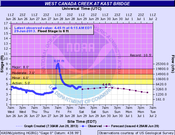
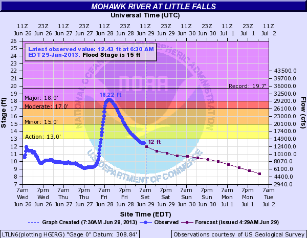
On June 23rd, slow-moving thunderstorms moved over the same areas (trained) of southern Herkimer County which were already saturated from previous rainfall events over the last several weeks. Flash flooding occurred with the towns of Middleville and Herkimer hardest hit with several road washouts, reports of debris in roadways, and homes being flooded. Little Falls also experienced flash flooding with roads being washed out. Homes in Kast Bridge were flooded as well as roads being closed. Multiple roads were also washed out in Fairfield. West Canada Creek at Kast Bridge and Mohawk River at Little Falls.
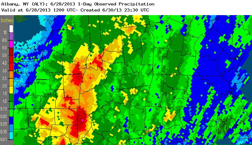
After several weeks of very wet weather, the ground across the region was already quite saturated due to recent flooding making the region susceptible to flooding. On June 28th, heavy rainfall occurred across the Mohawk Valley and western Adirondacks with rainfall fell at rates of nearly one inch per hour at times with a total rainfall of three to five inches. This led to significant flash flooding across both the Mohawk Valley and Adirondacks. Many roads were washed out and closed, including a portion of the New York State Thruway between exits 29 (Canajoharie) and 29A (Little Falls). In addition, urbanized areas along the Mohawk River experienced dangerous amounts of flooding. The entire town of Fort Plain was under water and many swift water rescues had to take place. The West Canada Creek at Kast Bridge and the Mohawk River at Little Falls both experienced major flooding.
Several rounds of thunderstorms moved across the area mainly along and north of Interstate 90. The storms resulted in torrential rainfall and flash flooding in portions of Herkimer, Fulton, Warren, Washington, and Rensselaer Counties. It was the second straight day of heavy rainfall for some of these areas. The village of Hoosick Falls was hit particularly hard by flash flooding, with many residences experiencing basement and first-floor flooding and several roads washed out as Woods Brook overwhelmed its flood protection system and coursed through the town. A state of emergency was declared for the village, where an estimated $300,000 in damage occurred. Across Rensselaer County, flooding resulted in an estimated $3.6 million in damage. Rainfall amounts up to 4 inches were recorded in Washington County where several roads were washed out. Neighboring Warren County estimated $1 million in flood damage. In Herkimer County, a mudslide closed a state highway, and people had to be evacuated from locations in the villages of Herkimer and Frankfort due to rising water. Several area rivers reached minor and moderate flood stage, including the Mettawee River at Granville and West Canada Creek at Kast Bridge which crested just below major flood stage.
Back to Past Weather Events Page

