Overview
|
Multiple supercell thunderstorms developed across northeast Iowa and west central and southwestern Wisconsin during the afternoon of Tuesday, April 14th, 2026. These thunderstorms produced a strong EF3 tornado near Union Center, Wisconsin in addition to multiple reports of hail up to 3.5" in diameter across the region. Up to baseball size wind-driven hail caused widespread damage to Westby, Cashton, and other locations in Vernon County, WI. |
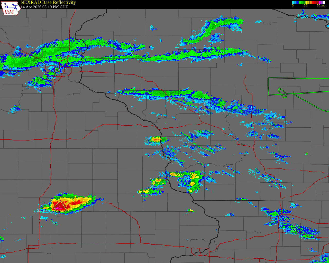 Radar loop with warnings issued during the April 14, 2026 severe storm event |
Tornadoes
Select a tornado from the table to zoom into the track and view more information. The default table view is limited to 8 tracks, but can be scrolled by a mouse wheel or dynamically expanded. Additionally, the table can fill the entire window by clicking the small circular expanding arrow icon at the very top right of the table and returned to its original size by clicking the button again. The side information panel that opens over the map can be closed using the "X" on the upper right corner of the pop-up. Zoom into the map and click damage points to see detailed information and pictures from the surveys.
|
NOTE: times shown below are local to your device's time zone. |

The Enhanced Fujita (EF) Scale classifies tornadoes into the following categories:
| EF0 Weak 65-85 mph |
EF1 Moderate 86-110 mph |
EF2 Significant 111-135 mph |
EF3 Severe 136-165 mph |
EF4 Extreme 166-200 mph |
EF5 Catastrophic 200+ mph |
 |
|||||
| Tornadoes that fail to impact any ratable damage indicators on the EF-Scale are rated EF-Unknown (EF-U) | |||||
Storm Reports
 |
| Map of storm reports received covering the April 14th, 2026 severe weather event. Click to zoom in. (Map by Iowa Environmental Mesonet; reports collected by NWS) |
Preliminary Local Storm Report...Summary
National Weather Service La Crosse WI
844 AM CDT Wed Apr 15 2026

..TIME...   ...EVENT...      ...CITY LOCATION...     ...LAT.LON...
..DATE...   ....MAG....      ..COUNTY LOCATION..ST.. ...SOURCE....
            ..REMARKS..

0520 PM     Funnel Cloud     2 WNW Strawberry Point  42.69N 91.57W
04/14/2026                   Clayton            IA   Public


0411 PM     Hail             Monona                  43.05N 91.39W
04/14/2026  E2.50 Inch       Clayton            IA   Public

            Time estimated via radar.

0425 PM     Hail             4 ENE Genoa             43.60N 91.15W
04/14/2026  M1.00 Inch       Vernon             WI   Trained Spotter


0425 PM     Hail             7 W Nashua              42.95N 92.67W
04/14/2026  M1.75 Inch       Floyd              IA   County Official


0430 PM     Hail             1 SSW Charles City      43.05N 92.68W
04/14/2026  E2.75 Inch       Floyd              IA   Public

            Golf ball to baseball.

0432 PM     Hail             1 E Charles City        43.06N 92.65W
04/14/2026  E0.75 Inch       Floyd              IA   Public

            Report from mPING: Dime (0.75 in.).

0438 PM     Hail             1 SW Charles City       43.06N 92.68W
04/14/2026  E1.00 Inch       Floyd              IA   Public

            Report from mPING: Quarter (1.00 in.).

0440 PM     Hail             1 E Charles City        43.07N 92.66W
04/14/2026  M3.25 Inch       Floyd              IA   Public


0440 PM     Hail             3 E Charles City        43.07N 92.61W
04/14/2026  M2.00 Inch       Floyd              IA   Public

            Image frrom County Emergency Management on
            NWS Chat.

0445 PM     Hail             Westby                  43.65N 90.86W
04/14/2026  M2.00 Inch       Vernon             WI   Public

            Photo provided via social media.

0445 PM     Hail             4 E Coon Valley         43.73N 90.94W
04/14/2026  E0.75 Inch       La Crosse          WI   Public

            Report from mPING: Dime (0.75 in.).

0446 PM     Hail             1 WNW Esofea            43.64N 90.98W
04/14/2026  E1.75 Inch       Vernon             WI   Public


0450 PM     Hail             3 ENE Floyd             43.14N 92.68W
04/14/2026  E2.50 Inch       Floyd              IA   Public


0451 PM     Hail             Westby                  43.65N 90.86W
04/14/2026  M2.75 Inch       Vernon             WI   Law Enforcement

            Windshields broken on patrol car.

0456 PM     Hail             Elma                    43.24N 92.44W
04/14/2026  M3.50 Inch       Howard             IA   Public


0457 PM     Hail             3 SW Cashton            43.71N 90.82W
04/14/2026  E2.75 Inch       Vernon             WI   Public


0505 PM     Hail             3 NE Mount Hope         43.00N 90.82W
04/14/2026  M1.00 Inch       Grant              WI   Public


0505 PM     Hail             1 WNW Alta Vista        43.20N 92.43W
04/14/2026  E1.75 Inch       Chickasaw          IA   Fire Dept/Rescue


0509 PM     Hail             Elma                    43.24N 92.44W
04/14/2026  E2.75 Inch       Howard             IA   Fire Dept/Rescue


0515 PM     Hail             Mount Hope              42.97N 90.86W
04/14/2026  E2.00 Inch       Grant              WI   Public

            Picture provided via social media.

0515 PM     Hail             Saratoga                43.37N 92.41W
04/14/2026  E2.75 Inch       Howard             IA   Public

            Time estimated via radar.

0531 PM     Hail             1 N Hillsboro           43.66N 90.34W
04/14/2026  E1.00 Inch       Vernon             WI   Public

            Report from mPING: Quarter (1.00 in.).

0534 PM     Hail             3 W Hillsboro           43.66N 90.39W
04/14/2026  M1.00 Inch       Vernon             WI   Fire Dept/Rescue


0534 PM     Hail             Patch Grove             42.94N 90.97W
04/14/2026  M1.00 Inch       Grant              WI   Trained Spotter


0536 PM     Hail             Patch Grove             42.94N 90.97W
04/14/2026  E0.50 Inch       Grant              WI   Public

            Report from mPING: Half-inch (0.50 in.).

0536 PM     Hail             Montfort                42.97N 90.43W
04/14/2026  E0.75 Inch       Grant              WI   Public

            Report from mPING: Dime (0.75 in.).

0537 PM     Hail             Coon Valley             43.70N 91.02W
04/14/2026  E1.25 Inch       Vernon             WI   Public


0538 PM     Hail             1 SSE Hillsboro         43.64N 90.33W
04/14/2026  M1.75 Inch       Vernon             WI   Public


0540 PM     Hail             1 WNW Harmony           43.56N 92.03W
04/14/2026  M1.50 Inch       Fillmore           MN   Trained Spotter


0553 PM     Hail             Harmony                 43.55N 92.01W
04/14/2026  E1.00 Inch       Fillmore           MN   Public

            Report from mPING: Quarter (1.00 in.).

0555 PM     Hail             6 ENE Wonewoc           43.70N 90.11W
04/14/2026  M1.00 Inch       Juneau             WI   Emergency Mngr


0600 PM     Hail             4 SSW Plainville        43.67N 89.83W
04/14/2026  M3.00 Inch       Juneau             WI   Trained Spotter


0606 PM     Hail             2 SW Esofea             43.61N 90.98W
04/14/2026  E0.50 Inch       Vernon             WI   Public

            Report from mPING: Half-inch (0.50 in.).

0606 PM     Hail             3 E Plainville          43.70N 89.76W
04/14/2026  E0.75 Inch       Adams              WI   Public

            Report from mPING: Dime (0.75 in.).

0610 PM     Hail             3 E Plainville          43.70N 89.76W
04/14/2026  E0.75 Inch       Adams              WI   Public

            Report from mPING: Dime (0.75 in.).

0617 PM     Hail             Millston                44.19N 90.64W
04/14/2026  M2.50 Inch       Jackson            WI   Public

            Photo provided via social media.

0625 PM     Hail             Bratsberg               43.74N 91.77W
04/14/2026  E1.25 Inch       Fillmore           MN   Public

            1 to 1 1/4 inch hail.

0904 PM     Hail             4 S Gillingham          43.37N 90.45W
04/14/2026  M1.00 Inch       Richland           WI   Public


0852 AM     Rain             3 SW Cummingsville      43.85N 92.30W
04/14/2026  E0.60 Inch       Olmsted            MN   Public

            .

0852 AM     Rain             3 SW Cummingsville      43.85N 92.30W
04/14/2026  E0.60 Inch       Olmsted            MN   Public


0705 AM     Rain             1 W Platteville         42.74N 90.49W
04/15/2026  M1.30 Inch       Grant              WI   Amateur Radio


0712 AM     Rain             1 S De Soto             43.41N 91.19W
04/15/2026  M0.15 Inch       Crawford           WI   Public


0525 PM     Tornado          5 E Mount Hope          42.97N 90.76W
04/14/2026                   Grant              WI   Trained Spotter


0537 PM     Tornado          2 WNW Union Center      43.69N 90.29W
04/14/2026                   Juneau             WI   Emergency Mngr

            Radar confirmed tornado with debris
            signature. House destroyed on Raese Rd
            northwest of Union Center. The tornado was
            reported to continue northeast crossing
            State Highway 80 before dissipating
            northeast of Union Center. Lots of tree and
            power pole damage along its path.

0654 PM     Tstm Wnd Gst     3 W Sinsinawa           42.52N 90.61W
04/14/2026  M70 MPH          Grant              WI   Emergency Mngr
Rain Reports
 |
| Map of radar-estimated rainfall on April 14th, 2026. Click to zoom. (NWS) |
Public Information Statement
National Weather Service La Crosse WI
1015 AM CDT Wed Apr 15 2026

...PRECIPITATION REPORTS FROM APRIL 14...

Location                     Amount    Time/Date       Lat/Lon

...Iowa...

...Allamakee County...
3 SE Waterville              0.53 in   0807 AM 04/15   43.17N/91.24W

...Clayton County...
Guttenberg 0.6 N             0.85 in   0700 AM 04/15   42.80N/91.10W
Elkader 6.8 WSW              0.83 in   0630 AM 04/15   42.81N/91.52W
McGregor 6.4 WNW             0.81 in   0647 AM 04/15   43.07N/91.29W
Guttenberg Dam 10            0.71 in   0600 AM 04/15   42.79N/91.10W
Mcgregor                     0.51 in   0843 AM 04/15   43.02N/91.19W

...Fayette County...
Oelwein 1 E                  0.88 in   0630 AM 04/15   42.68N/91.88W

...Mitchell County...
St.Ansgar                    0.61 in   0536 PM 04/14   43.38N/92.92W

...Minnesota...

...Dodge County...
Hayfield                     0.99 in   0537 PM 04/14   43.89N/92.85W
Kasson 5.7 SE                0.92 in   0900 AM 04/14   43.96N/92.68W

...Fillmore County...
Harmony 0.3 S                0.78 in   0700 AM 04/15   43.55N/92.01W
Lanesboro                    0.55 in   0530 PM 04/14   43.72N/91.98W
1 NNW Fillmore               0.52 in   0530 PM 04/14   43.76N/92.27W

...Mower County...
Austin                       1.49 in   0539 PM 04/14   43.65N/93.00W
Austin Municipal Airport     0.88 in   0535 PM 04/14   43.67N/92.92W
Dobbins Creek                0.80 in   0530 PM 04/14   43.68N/92.94W

...Olmsted County...
3 E Rochester                1.75 in   0953 AM 04/14   44.02N/92.42W
Byron 3.2 N                  1.53 in   0100 PM 04/14   44.08N/92.65W
Rochester 1.9 SSE            1.49 in   0530 PM 04/14   43.99N/92.47W
Rochester 5.9 E              1.27 in   1107 AM 04/14   44.00N/92.36W
Rochester-Beltline Bear Cree 1.16 in   0530 PM 04/14   44.01N/92.45W
Rochester                    1.10 in   0540 PM 04/14   44.09N/92.49W
Rochester                    1.07 in   0540 PM 04/14   44.09N/92.51W
Rochester 5.5 N              1.01 in   0915 AM 04/14   44.10N/92.47W
Rochester 3.0 NE             1.01 in   1100 AM 04/14   44.05N/92.44W
Mayo Helipad                 0.98 in   0535 PM 04/14   44.02N/92.48W
Rochester 5.7 N              0.94 in   0945 AM 04/14   44.10N/92.46W
3 ENE Rochester              0.90 in   0530 PM 04/14   44.03N/92.43W
Rochester International Airp 0.89 in   0541 PM 04/14   43.90N/92.50W
1 W Oronoco                  0.86 in   0530 PM 04/14   44.17N/92.55W
Rochester                    0.85 in   0530 PM 04/14   44.18N/92.41W
Byron                        0.77 in   0545 PM 04/14   44.03N/92.63W
3 SW Cummingsville           0.60 in   0852 AM 04/14   43.85N/92.30W
5 WSW Rochester              0.58 in   0500 PM 04/14   43.98N/92.56W
3 N Rochester                0.55 in   0515 PM 04/14   44.06N/92.47W

...Wabasha County...
Lake City                    2.68 in   0530 PM 04/14   44.44N/92.28W
Lake City                    2.43 in   0540 PM 04/14   44.44N/92.27W
1 N Kellogg                  1.29 in   0500 PM 04/14   44.32N/92.00W
3 ESE Mazeppa                0.51 in   0530 PM 04/14   44.26N/92.49W

...Winona County...
1 NW Winona                  1.80 in   1231 PM 04/14   44.05N/91.67W
1 WSW Elba                   1.23 in   0445 PM 04/14   44.09N/92.03W
1 ESE Winona                 1.17 in   0540 PM 04/14   44.04N/91.63W
Plainview                    1.13 in   0532 PM 04/14   44.05N/91.65W
Whitewater State Park        0.88 in   0445 PM 04/14   44.05N/92.05W
Dakota                       0.84 in   0515 PM 04/14   43.91N/91.36W
3 SW Elba                    0.77 in   0530 PM 04/14   44.06N/92.05W

...Wisconsin...

...Adams County...
Plainville                   0.74 in   0838 AM 04/15   43.72N/89.78W
Oxford 4.0 W                 0.63 in   0700 AM 04/15   43.79N/89.64W
Nekoosa 8.0 SSE              0.55 in   0800 AM 04/15   44.21N/89.85W

...Buffalo County...
Alma 0.7 SSE                 2.10 in   0500 PM 04/14   44.32N/91.92W
Mondovi                      1.33 in   0500 PM 04/14   44.56N/91.67W

...Clark County...
Neillsville 1W               2.27 in   0500 PM 04/14   44.56N/90.61W
NEILLSVILLE                  1.19 in   0535 PM 04/14   44.61N/90.65W
COLBY                        0.87 in   0536 PM 04/14   44.91N/90.32W

...Crawford County...
Steuben 4SE                  0.64 in   0700 AM 04/15   43.13N/90.84W
Gays Mills 0.4 SE            0.54 in   0700 AM 04/15   43.32N/90.85W
Gays Mills                   0.52 in   0700 AM 04/15   43.32N/90.85W
Eastman                      0.50 in   0212 PM 04/14   43.17N/91.02W

...Grant County...
Fennimore                    1.35 in   0844 AM 04/15   42.98N/90.66W
Dickeyville 0.1 SW           1.30 in   0700 AM 04/15   42.62N/90.59W
1 W Platteville              1.30 in   0705 AM 04/15   42.74N/90.49W
Platteville                  1.23 in   0835 AM 04/15   42.74N/90.46W
Muscoda 0.5 WSW              1.21 in   0733 AM 04/15   43.18N/90.44W
Bloomington 3.5 N            0.92 in   0703 AM 04/15   42.94N/90.92W
1 NE Platteville             0.91 in   0700 AM 04/15   42.75N/90.46W
Patch Grove 0.1 NNW          0.91 in   0700 AM 04/15   42.94N/90.97W
Cassville 7.8 ENE            0.88 in   0700 AM 04/15   42.75N/90.84W
Prairie Du Chien 9.9 SE      0.87 in   0700 AM 04/15   42.95N/90.99W
Lancaster                    0.81 in   0741 AM 04/15   42.83N/90.69W
Boscobel                     0.68 in   0803 AM 04/15   43.15N/90.68W
4 S Muscoda                  0.63 in   0630 AM 04/15   43.12N/90.45W
4.3 W Lancaster              0.62 in   0800 AM 04/15   42.83N/90.79W

...Jackson County...
1 E Black River Falls        0.54 in   0815 AM 04/15   44.30N/90.73W

...Juneau County...
1.0 E Mauston                2.02 in   0630 AM 04/15   43.79N/90.06W
3 ESE Lemonweir              0.91 in   0530 AM 04/15   43.77N/89.96W
New Lisbon                   0.55 in   0830 AM 04/15   43.87N/90.17W

...La Crosse County...
Burns                        0.99 in   0536 PM 04/14   43.91N/90.97W
Bangor                       0.92 in   0540 PM 04/14   43.89N/90.99W
La Crosse                    0.91 in   0530 PM 04/14   43.77N/91.22W

...Monroe County...
Tomah 7.5 SSW                0.66 in   0700 AM 04/15   43.90N/90.58W

...Taylor County...
Medford                      1.03 in   0530 PM 04/14   45.30N/90.30W

...Trempealeau County...
Trempealeau                  1.18 in   0536 PM 04/14   44.07N/91.51W
2 ENE Marshland              0.91 in   0540 PM 04/14   44.09N/91.51W

...Vernon County...
La Farge                     1.30 in   0830 AM 04/15   43.60N/90.63W
Westby 0.4 E                 0.79 in   0500 AM 04/15   43.65N/90.85W
Viroqua 9.3 S                0.70 in   0531 AM 04/15   43.42N/90.87W
1 SSE Cashton                0.65 in   0700 AM 04/15   43.72N/90.77W
Westby 5.8 NW                0.59 in   0700 AM 04/15   43.70N/90.95W

Observations are collected from a variety of sources with varying
equipment and exposures. We thank all volunteer weather observers
for their dedication. Not all data listed are considered official.
Photos & Video
Header
 |
 |
 |
 |
| 2 inch diameter hail in Westby, WI (Amy Jankowski) |
2.25 inch diameter hail in Mount Hope, WI (Hillary Cliff) |
3.25" diameter hail in Westby, WI (Fred Casper) |
About 2.75" hail in Millston, WI (Lynn Marie) |
 |
|||
| Tree uprooted in Union Center, WI (Jenni Marie) |
Caption (source) |
Caption (source) |
Caption (source) |
| Caption (source) |
Caption (source) |
Caption (source) |
Caption (source) |
Extra
 |
 |
 |
 |
| Severe risk message 2.5 days in advance | Message increasing the morning of the event | Outlook for the mid afternoon issued early afternoon 4/14 | Demonstrating severe storms developing at 4:53p |
 |
 |
 |
|
| Looking ahead to the 5-7 pm time frame | Targeted message about the storm that generating the Union Center, WI tornado | Covering storms departing during the 7 yo 9 pm time frame | Caption (source) |
 |
Media use of NWS Web News Stories is encouraged! Please acknowledge the NWS as the source of any news information accessed from this site. |
|


 Weather Story
 Weather Map
 Local Radar