
Numerous strong to severe storms are expected to develop from mid afternoon through early evening. Damaging winds will be the main threat, but large hail and tornadoes are also possible. Have multiple ways to receive warnings and stay weather aware if you have outdoor plans. Read More >
Overview
|
Freezing rain impacted many areas along and north of Interstate 90 in Minnesota and as far south as the Wisconsin River in western Wisconsin during the overnight and morning hours of April 2, 2026. South of Interstate 94, impacts were more targeted on trees and power lines on ridgetops while valleys were left with just rain. Colder temperatures through the day kept ice in place on these surfaces while increasing winds resulted in continued tree and powerline damage through the day. Icing amounts south of I-94 was generally in the 0.1 to 0.2 inch range, with amounts around 0.3 inches in central Wisconsin. |
 Image of Icing at the NWS Office in La Crosse |
Photos & Video
 |
 |
 |
 |
| Ice Accretion at the NWS Office in La Crosse (NWS La Crosse) | Ice Accretion at the NWS Office in La Crosse (NWS La Crosse) | Ice Accretion at the NWS Office in La Crosse (NWS La Crosse) | Ice Accretion at the NWS Office in La Crosse (NWS La Crosse) |
 |
 |
 |
 |
| Tree Damage in Monroe County (Monroe County EMA) |
Tree Damage in Cashton, WI (Laurie Geier) |
Tree Damage in Westby, WI (Chad Berger) |
Tree Damage in Tomah, WI (Marie Preuss) |
Ice Reports
Ice Accumulation Reports
..TIME...   ...EVENT...      ...CITY LOCATION...     ...LAT.LON...
..DATE...   ....MAG....      ..COUNTY LOCATION..ST.. ...SOURCE....
            ..REMARKS..

0700 AM     Freezing Rain    2 E La Crosse           43.82N 91.19W
04/02/2026  M0.15 Inch       La Crosse          WI   Official NWS Obs


0716 AM     Freezing Rain    2 N Dorchester          45.04N 90.34W
04/02/2026  M0.20 Inch       Taylor             WI   Broadcast Media

            .

0716 AM     Freezing Rain    2 N Dorchester          45.04N 90.34W
04/02/2026  M0.20 Inch       Taylor             WI   Broadcast Media


0745 AM     Freezing Rain    Westboro                45.35N 90.30W
04/02/2026  M0.20 Inch       Taylor             WI   Public

            Flat Ice Measurement.

0745 AM     Freezing Rain    Westboro                45.35N 90.30W
04/02/2026  M0.20 Inch       Taylor             WI   Public

            Flat Ice Measurement.

0800 AM     Freezing Rain    Witoka                  43.93N 91.62W
04/02/2026  M0.15 Inch       Winona             MN   Public


0800 AM     Freezing Rain    Witoka                  43.93N 91.62W
04/02/2026  M0.15 Inch       Winona             MN   Public

            .

0840 AM     Freezing Rain    3 ESE Stockton          44.01N 91.71W
04/02/2026  M0.15 Inch       Winona             MN   Trained Spotter

            Radial ice measured on trees.

1200 PM     Freezing Rain    2 N Dorchester          45.04N 90.34W
04/02/2026  M0.30 Inch       Taylor             WI   Broadcast Media

            0.4 of sleet as well. Quite a few tree limbs
            and branches broken off.
Ice Damage Reports
..TIME...   ...EVENT...      ...CITY LOCATION...     ...LAT.LON...
..DATE...   ....MAG....      ..COUNTY LOCATION..ST.. ...SOURCE....
            ..REMARKS..

0630 AM     Snow/Ice Dmg     1 S Viroqua             43.55N 90.88W
04/02/2026                   Vernon             WI   Public

            Downed trees from accumulating ice due to
            freezing rain.

0714 AM     Snow/Ice Dmg     De Soto                 43.43N 91.19W
04/02/2026                   Vernon             WI   Public

            Downed trees from accumulating ice on trees
            due to freezing rain.

0800 AM     Snow/Ice Dmg     1 NW Adams              43.96N 89.83W
04/02/2026                   Adams              WI   Public

            Ice on roads and trees. Power outage due to
            storm.

0800 AM     Snow/Ice Dmg     1 NW Adams              43.96N 89.83W
04/02/2026                   Adams              WI   Public

            Ice on roads and trees. Power outage due to
            storm.

0800 AM     Snow/Ice Dmg     Richland Center         43.34N 90.38W
04/02/2026                   Richland           WI   Law Enforcement

            Multiple reports of tree branches and trees
            down across the county due to freezing rain.

0810 AM     Snow/Ice Dmg     1 SE Viroqua            43.55N 90.87W
04/02/2026                   Vernon             WI   Law Enforcement

            Reports of tree branches and trees down
            across the county from the freezing rain.

0810 AM     Snow/Ice Dmg     1 SE Viroqua            43.55N 90.87W
04/02/2026                   Vernon             WI   Law Enforcement

            Reports of tree branches and trees down
            across the county from the freezing rain.

0904 AM     Snow/Ice Dmg     4 NW Norwalk            43.87N 90.69W
04/02/2026                   Monroe             WI   Law Enforcement

            Several reports of trees down along State
            Highway 71.

1150 AM     Snow/Ice Dmg     4 S Tomah               43.93N 90.50W
04/02/2026                   Monroe             WI   Public

            Large tree limbs broken in backyard.

1150 AM     Snow/Ice Dmg     Oakdale                 43.96N 90.38W
04/02/2026                   Monroe             WI   Public

            Large tree branches down in yard.

1200 PM     Snow/Ice Dmg     Merrillan               44.45N 90.84W
04/02/2026                   Jackson            WI   Public

            Large tree snapped at the top.

1215 PM     Snow/Ice Dmg     Westby                  43.65N 90.86W
04/02/2026                   Vernon             WI   Public

            Large tree limbs down on a house.

1215 PM     Snow/Ice Dmg     Cashton                 43.74N 90.78W
04/02/2026                   Monroe             WI   Public

            Large tree limbs down in backyard.
Messaging
 |
 |
 |
 |
| Outlook graphic issued on March 31, 2026 |
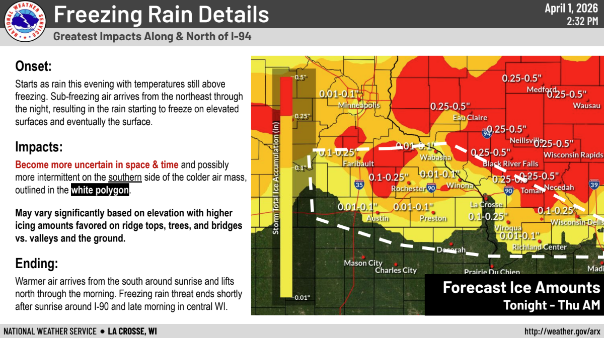
Weather Story issued the morning of April 1, 2026 | Partner briefing slide from the afternoon of April 1, 2026 | A graphic issued during the freezing rain on the morning of April 2, 2026 |
 |
Media use of NWS Web News Stories is encouraged! Please acknowledge the NWS as the source of any news information accessed from this site. |
|


 Weather Story
 Weather Map
 Local Radar