Overview
|
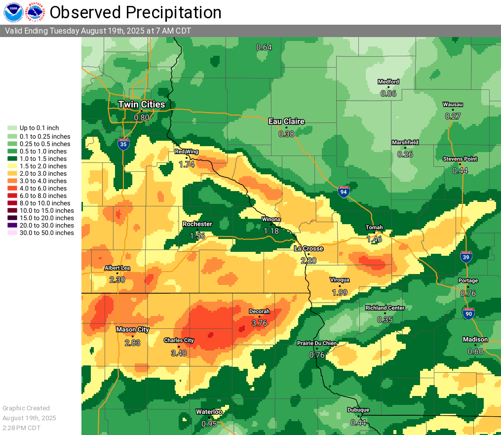
For multiple days, the region was in a heavy rainfall pattern that brought waves of showers and storms to the Upper Mississippi River Valley. Amazingly, Mother Nature hit different areas each day with heavy rain swaths, lessoning the impact somewhat. These swaths can be seen in the multi-day rainfall graphic to the right. The most significant flooding came on the last day (Monday, August 18) in the pattern from the very early morning into the afternoon. A band of 3 to 6 inches of rain fell from about Decorah to Charles City, Iowa. Many area rivers rose into minor flood stage with the worst flooding on the upper reaches of the Turkey river drainage and the Upper Iowa river. The cooperative observer in Decorah, IA measured 8.64" between 5 PM on August 17 and 5 PM August 18. This was their wettest August and wettest day. Previous record was 8.06" on August 23-24, 2016. They have been taking daily precipitation records since 1893. The greatest rainfall during this period was in Decorah, IA with a total of 12.54". |
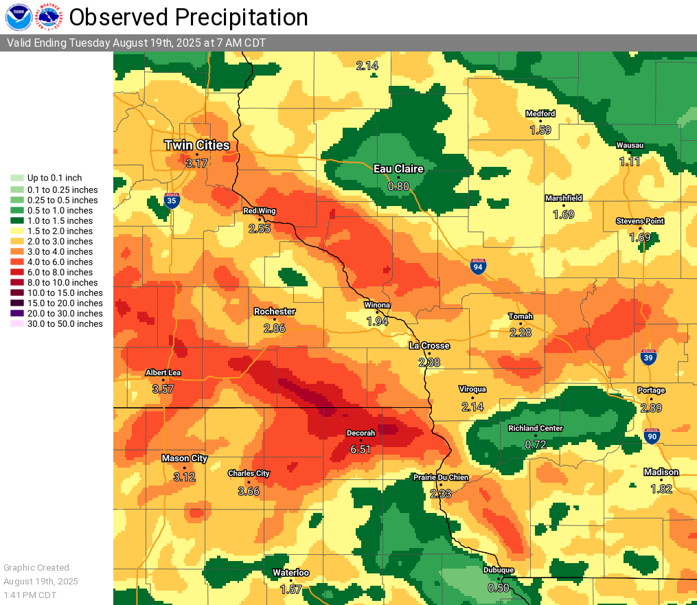 Precipitation Totals from 7am August 15 to 7 am August 19, 2025 |
|
Spring Valley, MN (cooperative observer) set daily rainfall records on 3 consecutive days. The following cooperative observing sites had one their 5 wettest days...
|
|
Flooding - Hydrographs
Cedar River Basin
 |
 |
 |
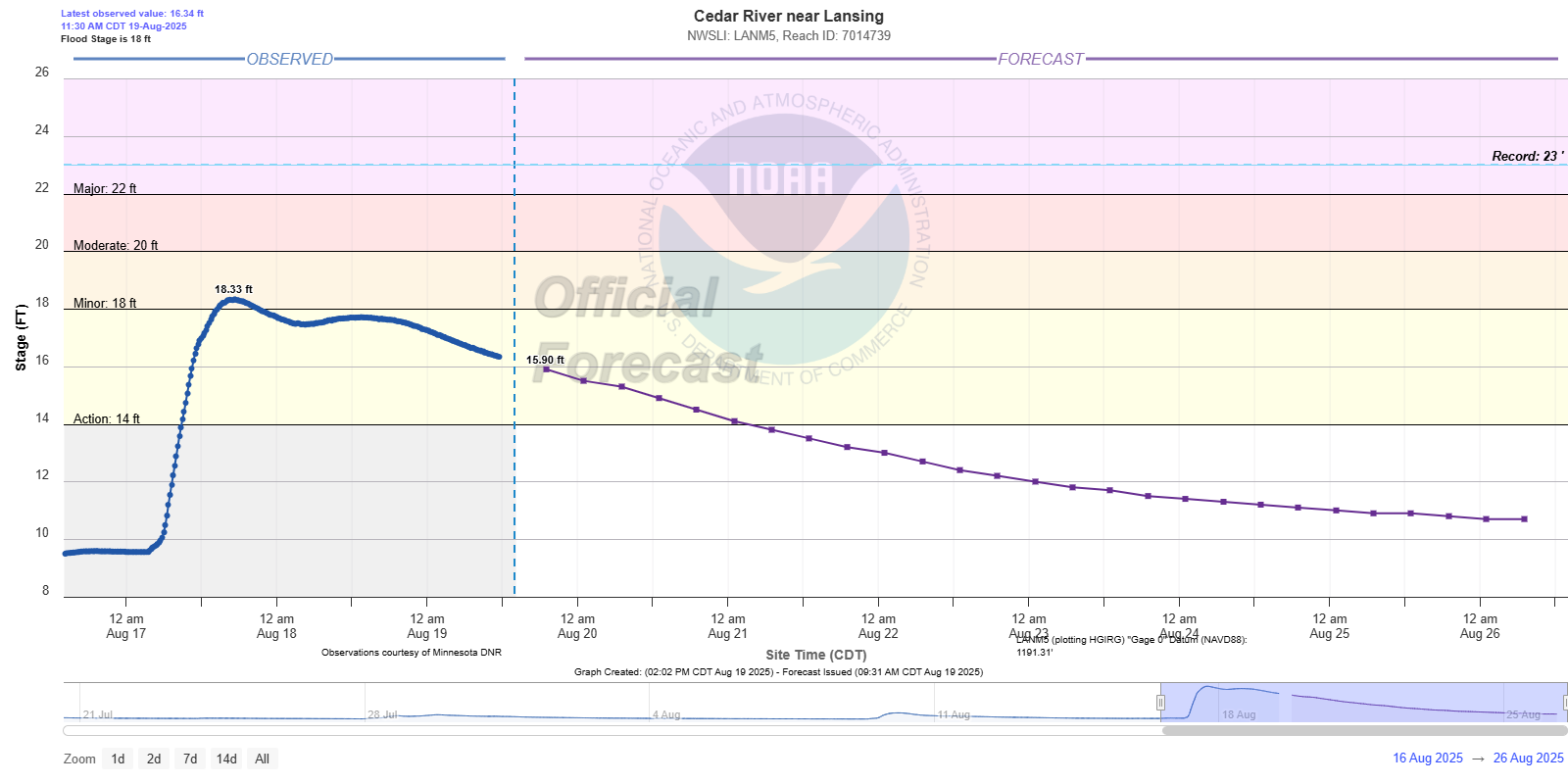
| Cedar River near Lansing, MN |
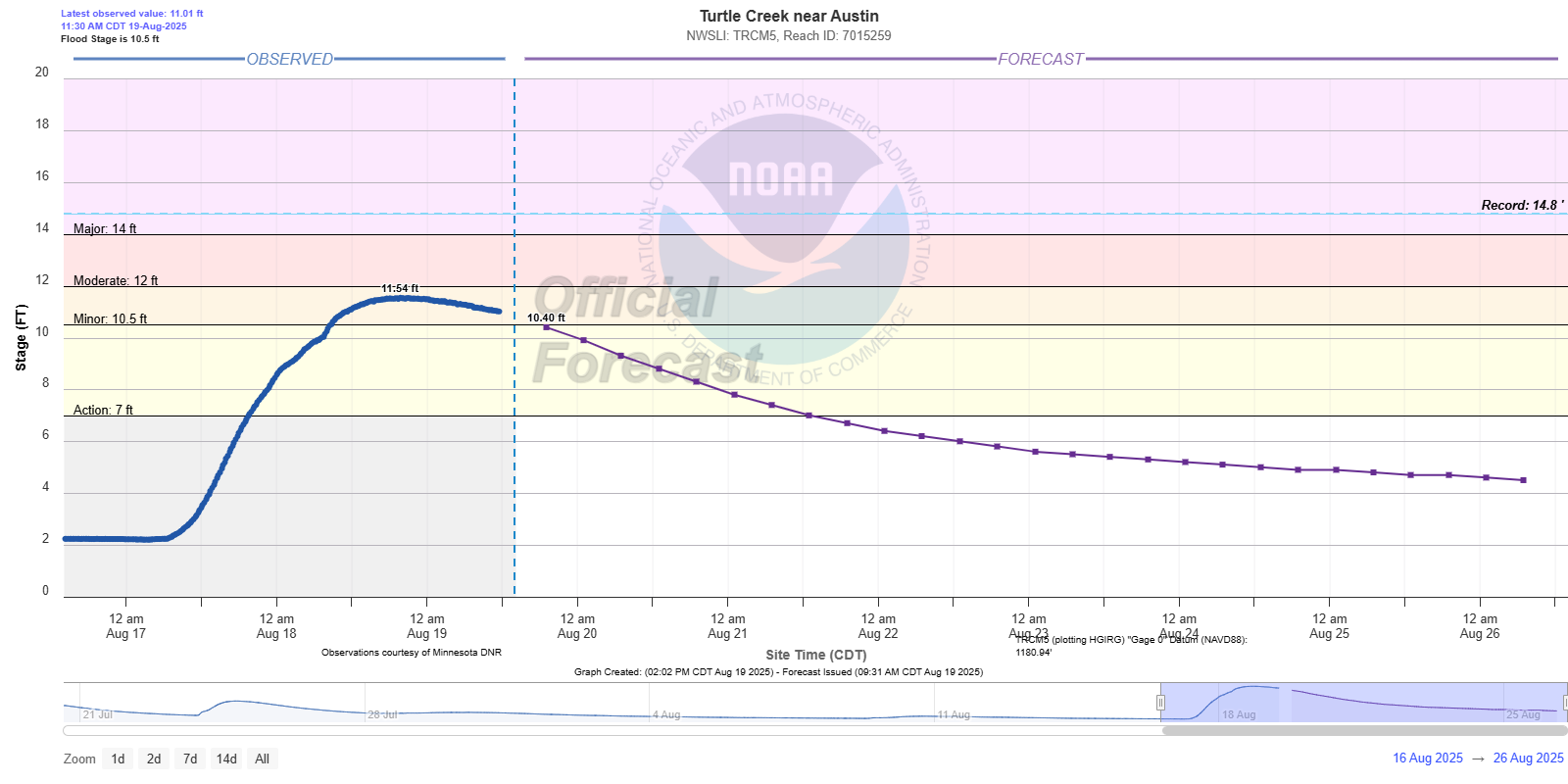
Turtle Creek near Austin, MN |
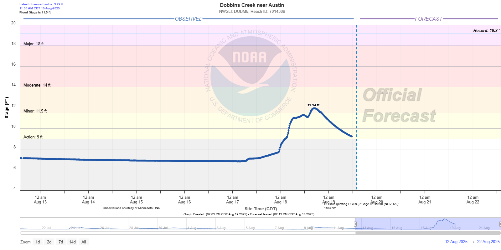
Dobbins Creek near Austin, MN |
 |
 |
 |
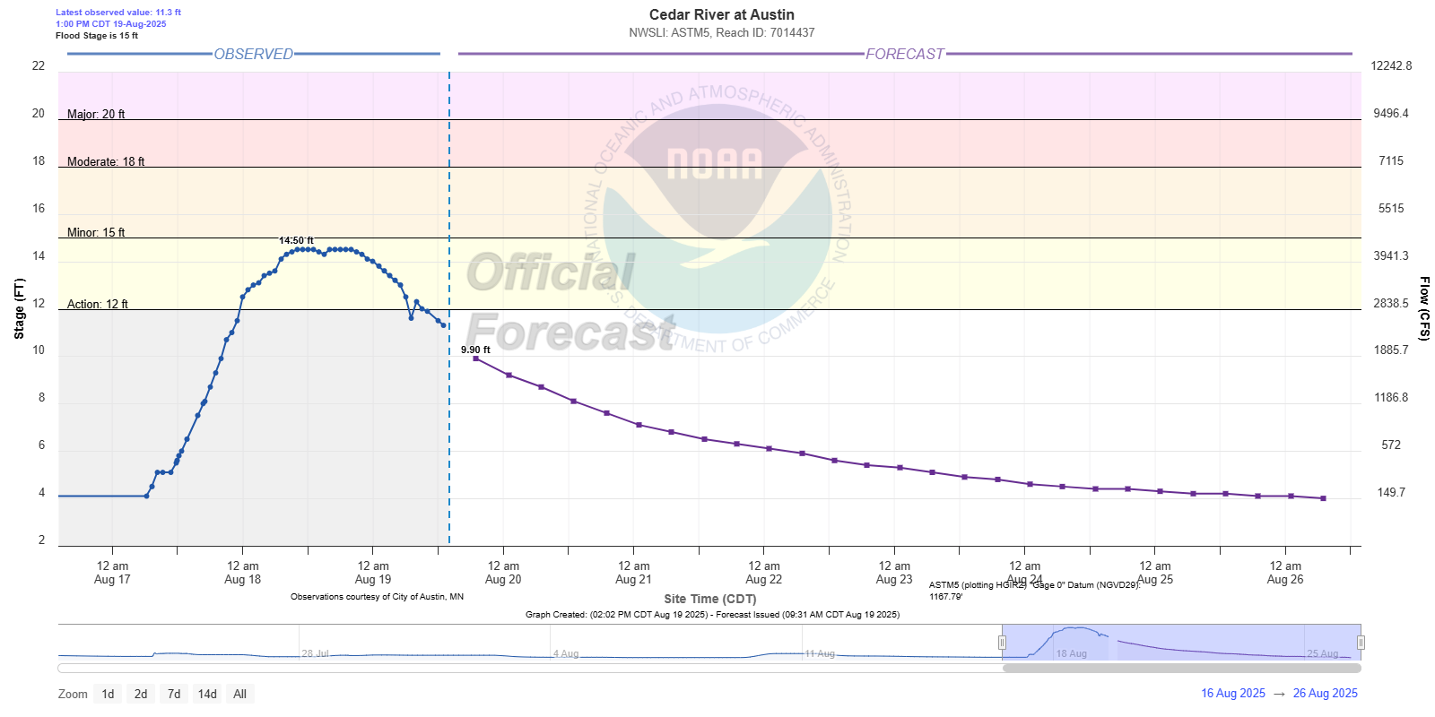
| Cedar River at Austin, MN |
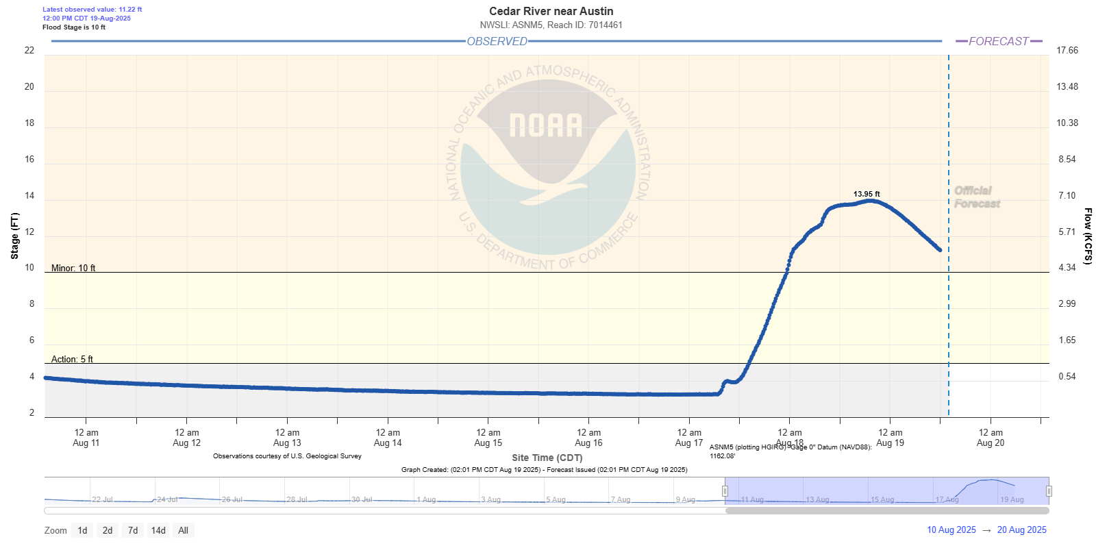
Cedar River near Austin, MN |
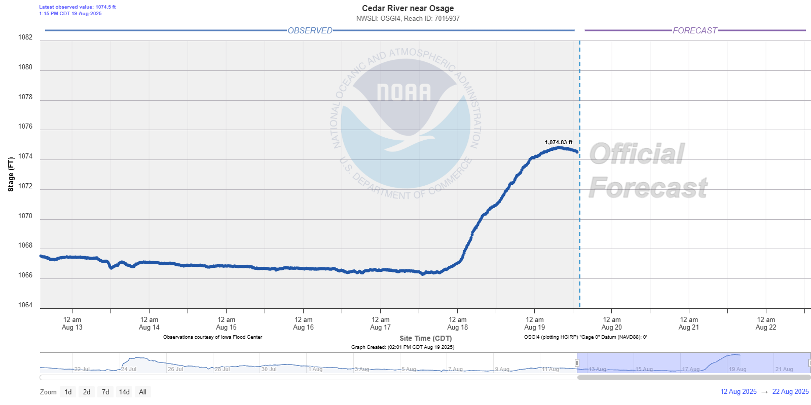
Cedar River near Osage, IA |
 |
 |
 |
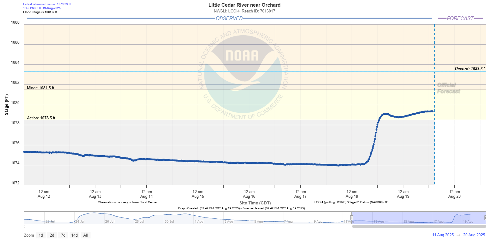
| Little Cedar River near Orchard, IA |
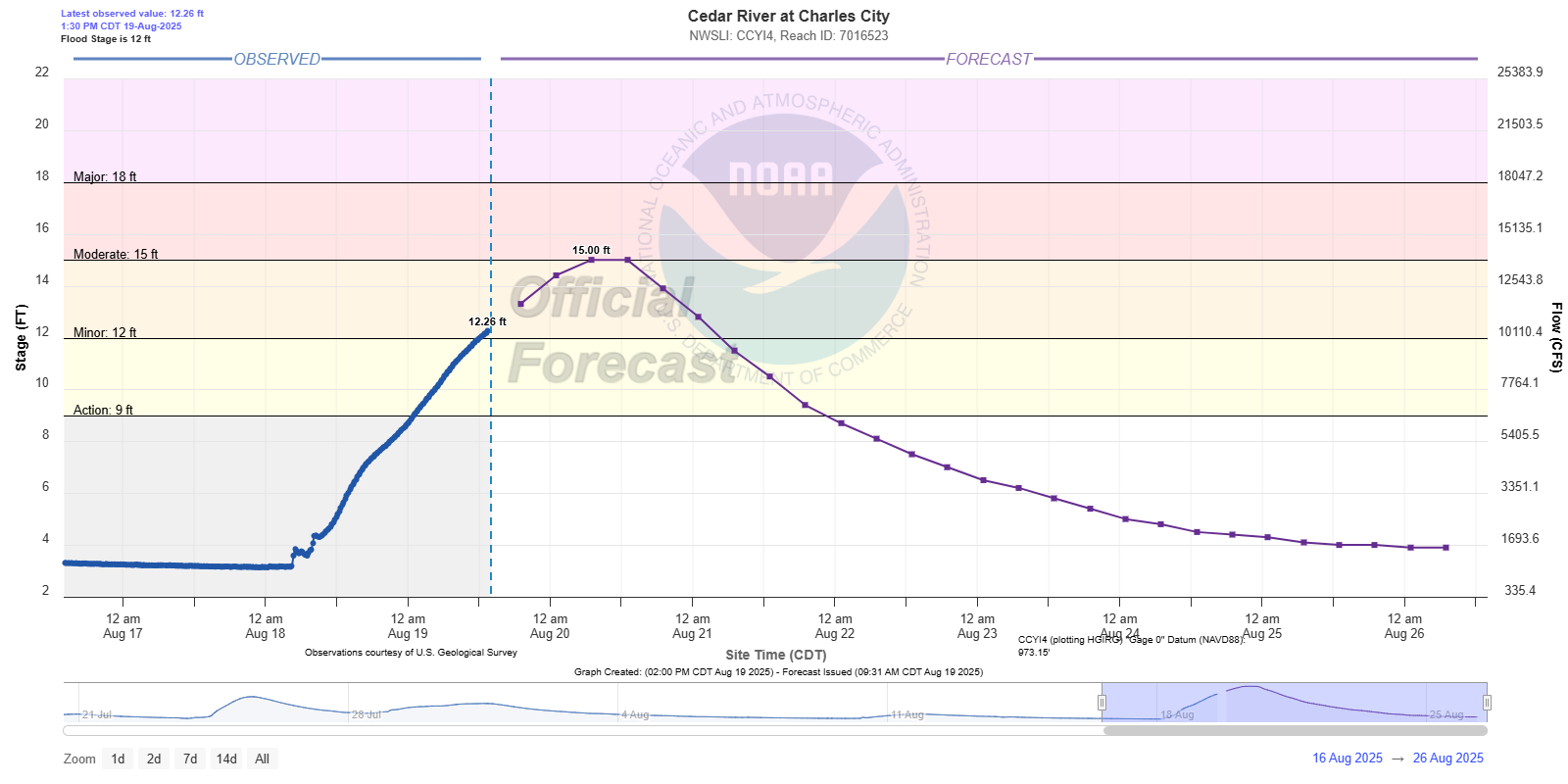
Cedar River at Charles City, IA |
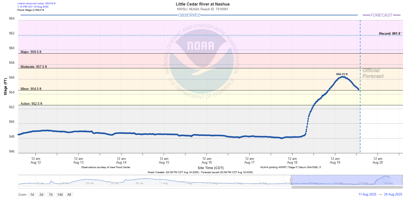
Little Cedar River at Nashua, IA |
Turkey River Basin
 |
 |
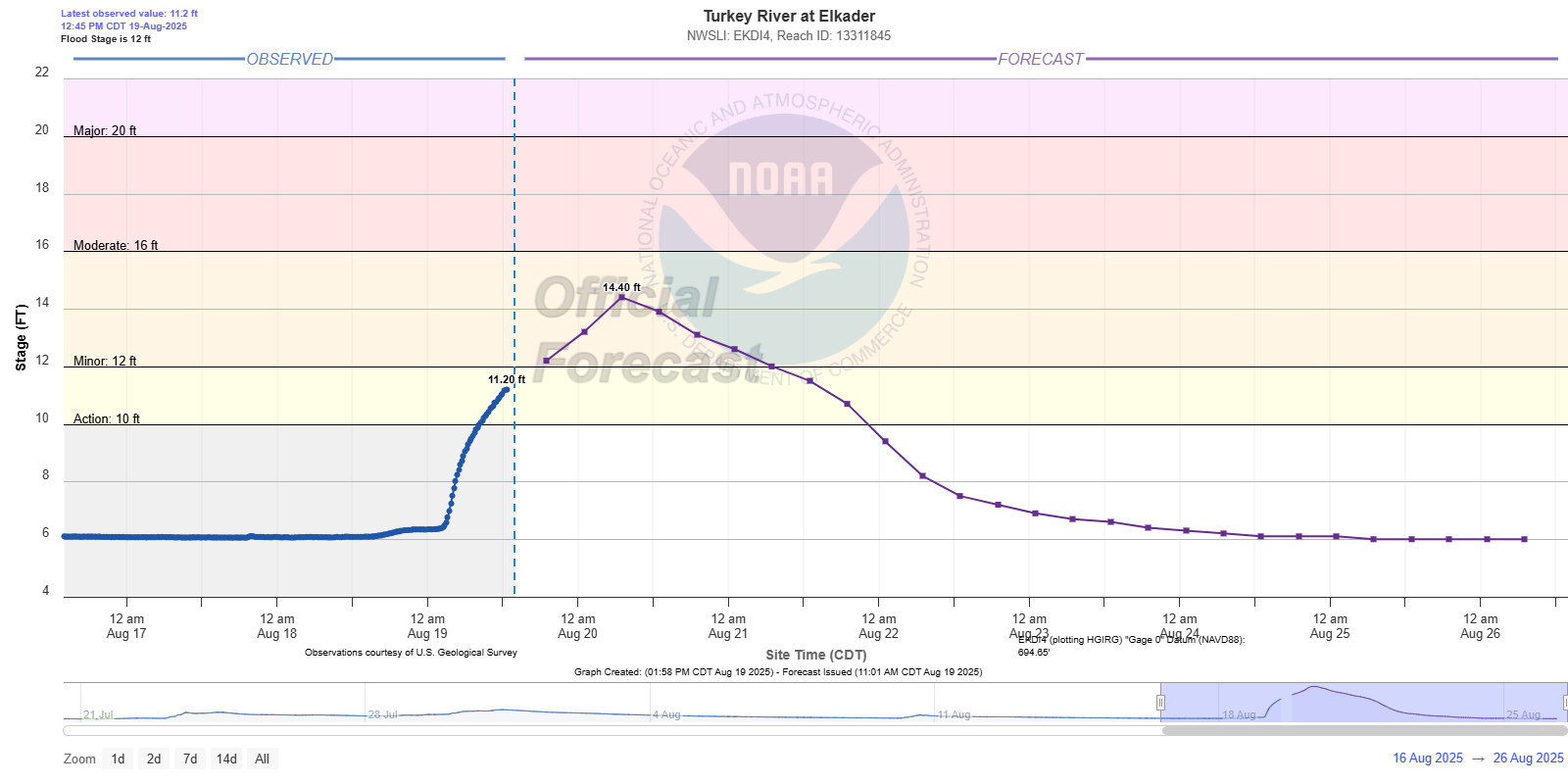 |
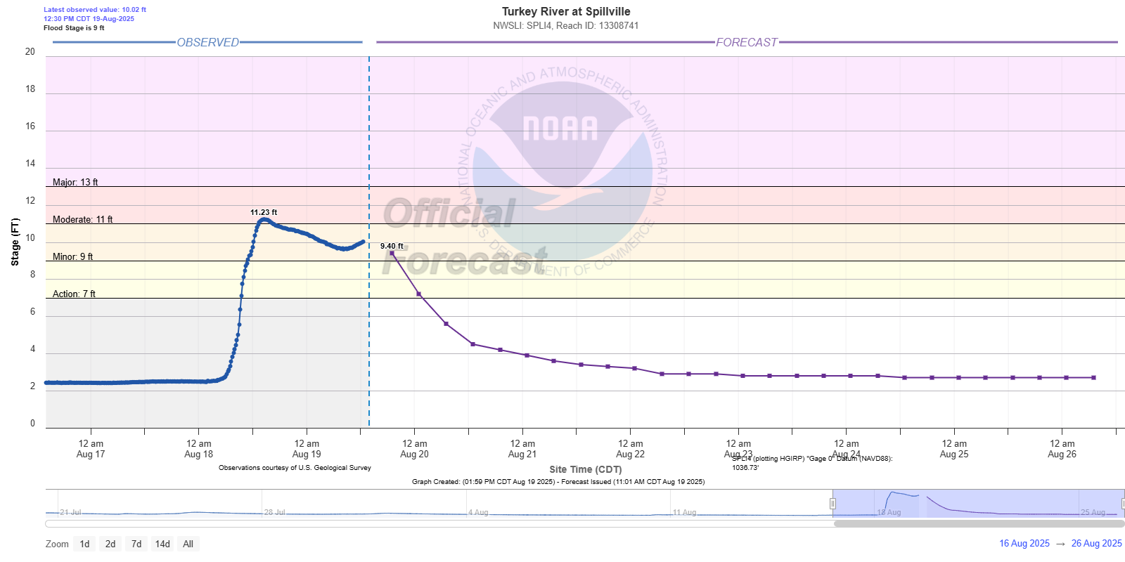
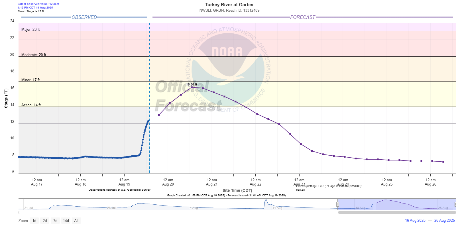
| Turkey River near Spillville, IA | Turkey River near Garber, IA | Turkey River near Elkader, IA |
Upper Iowa River Basin
 |
 |
 |
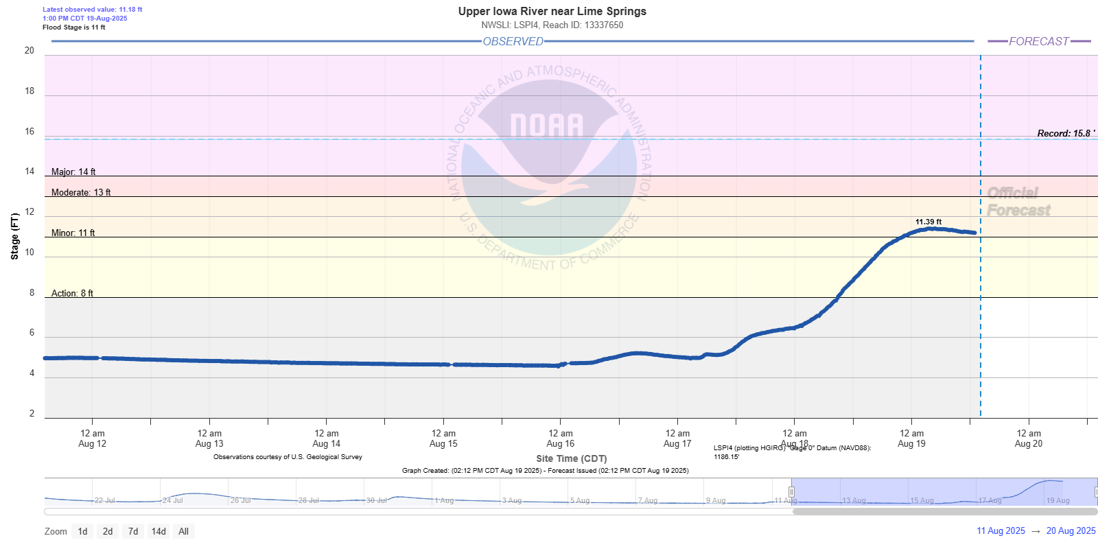
| Upper Iowa River near Lime Springs, IA |
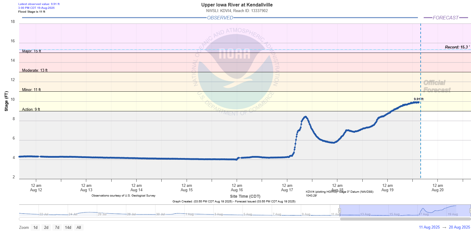
Upper Iowa River at Kendallville, IA |
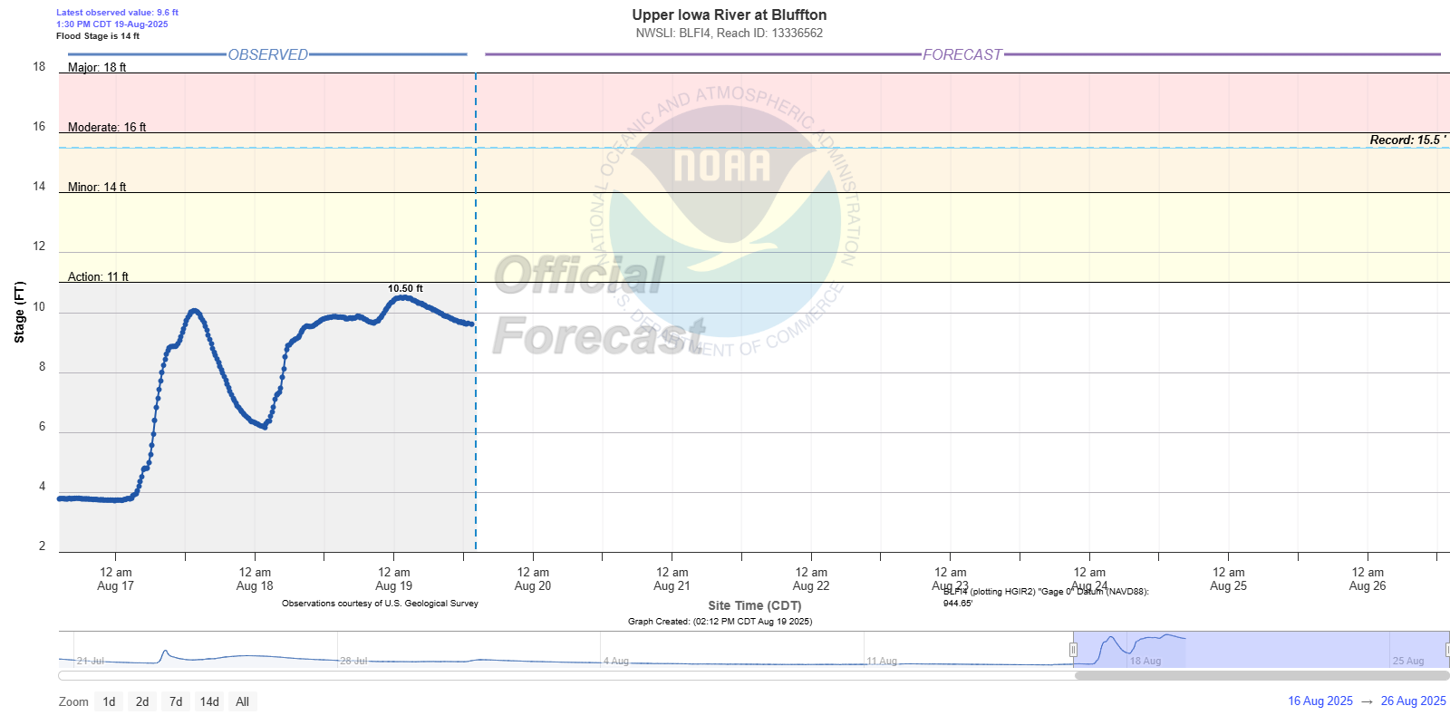
Upper Iowa River at Bluffton, IA |
 |
 |
 |
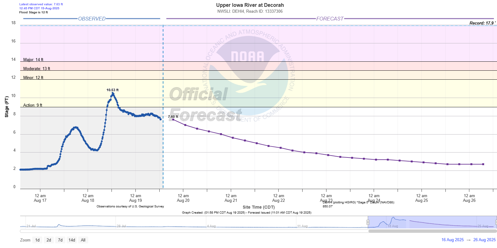
| Upper Iowa River at Decorah, IA |
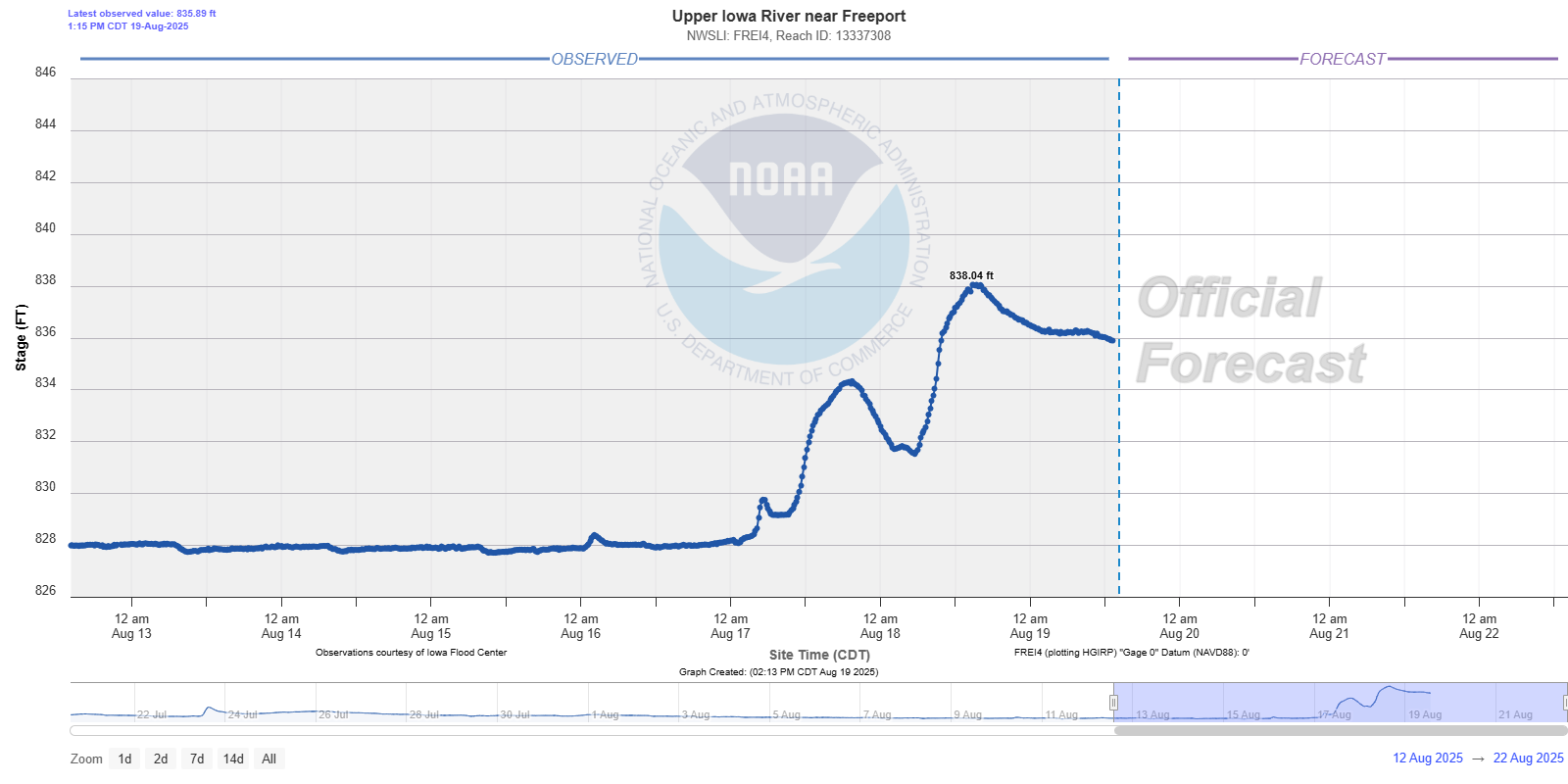
Upper Iowa River near Freeport, IA |
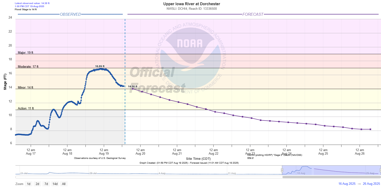
Upper Iowa River at Dorchester, IA |
Root River Basin
 near Pilot Mound.png) |
 above Rushford.png) |
 at Houston.png) |
| Root River near Pilot Mound, MN |
Root River near Rushford, MN |
Root River at Houston, MN |
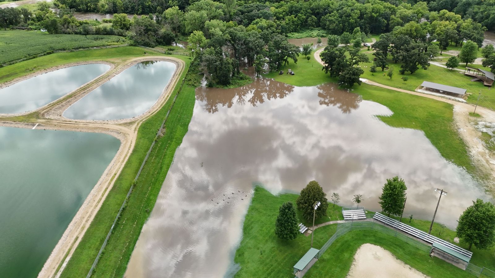
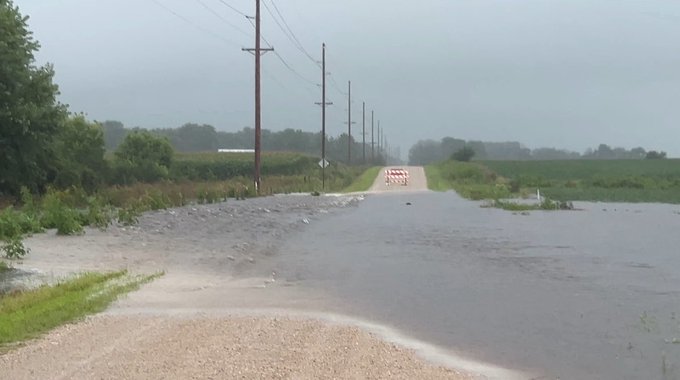
Flood Photos
 |
 |
 |
 |
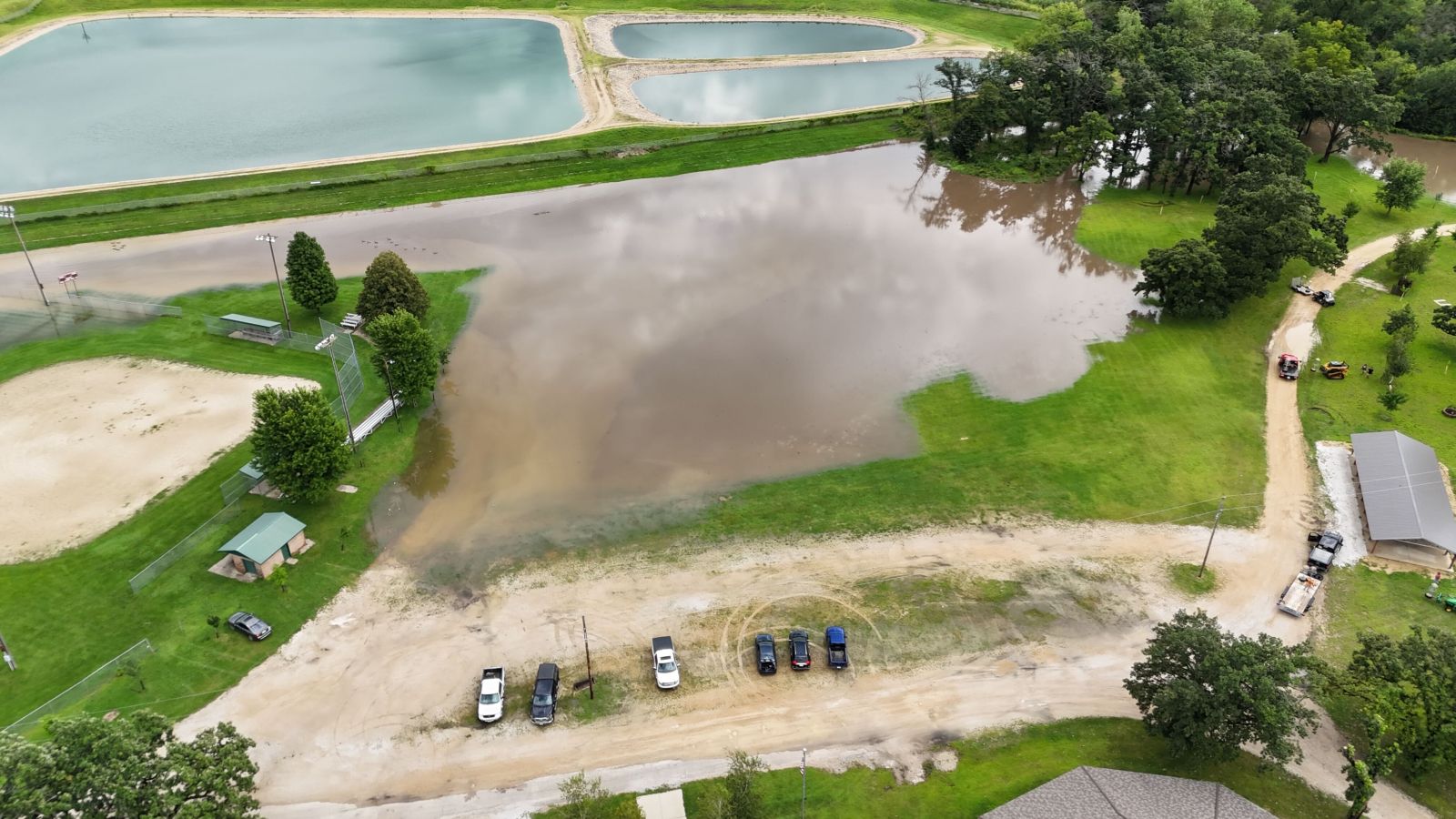
| Flooding near Spillville, IA | Flooding near Spillville, IA | Flooding near New Hampton, IA |
Rainfall Reports
|
 |
| Total Rainfall August 15-19 2025 (7am to 7am) |
2-day Rainfall Total August 17-19 2025 (7 am to 7am) |
Location                     Amount    Time/Date       Lat/Lon

...Iowa...

...Allamakee County...
3 S Dorchester               5.00 in   1200 PM 08/19   43.42N/91.51W
3 S Dorchester               4.90 in   0100 PM 08/19   43.42N/91.51W
Lansing 4.1 NW               3.98 in   0700 AM 08/19   43.40N/91.29W
3 SE Waterville              3.30 in   0107 PM 08/19   43.17N/91.24W
Monona 9.8 N                 3.01 in   0700 AM 08/19   43.19N/91.35W
Harpers Ferry 6.4 SSW        1.87 in   0700 AM 08/19   43.11N/91.20W

...Chickasaw County...
New Hampton                  3.96 in   0700 AM 08/19   43.06N/92.32W
New Hampton 0.4 SW           3.80 in   0700 AM 08/19   43.06N/92.32W
New Hampton                  3.61 in   0700 AM 08/19   43.06N/92.31W
Ionia 2W                     3.49 in   1245 PM 08/19   43.03N/92.50W
Fredericksburg 0.3 S         2.59 in   0800 AM 08/19   42.96N/92.20W

...Clayton County...
Monona 0.2 WNW               1.31 in   0630 AM 08/19   43.05N/91.39W
McGregor 6.4 WNW             1.24 in   0650 AM 08/19   43.07N/91.29W
Guttenberg 0.6 N             0.79 in   0800 AM 08/19   42.80N/91.10W
Elkader 6.8 WSW              0.78 in   0615 AM 08/19   42.81N/91.52W
Strawberry Point             0.74 in   0700 AM 08/19   42.69N/91.53W

...Fayette County...
Fayette                      2.15 in   0700 AM 08/19   42.88N/91.83W

...Floyd County...
Charles City 1.2 ESE         4.36 in   0701 AM 08/19   43.06N/92.65W
2 NE Dougherty               2.80 in   1120 AM 08/19   42.95N/93.01W
Nashua 2SW                   2.24 in   0700 AM 08/19   42.94N/92.57W
Nora Springs 2.4 SSE         2.10 in   0700 AM 08/19   43.11N/92.99W

...Howard County...
Riceville                    5.71 in   0115 PM 08/19   43.36N/92.48W
Lime Springs 1.5 N           5.42 in   0700 AM 08/19   43.47N/92.28W
Saratoga                     3.98 in   0115 PM 08/19   43.35N/92.42W

...Mitchell County...
Osage 0.6 ENE                2.59 in   0700 AM 08/19   43.29N/92.80W
Osage 4.7 E                  2.59 in   0700 AM 08/19   43.28N/92.72W
St.Ansgar                    2.40 in   0118 PM 08/19   43.38N/92.92W
St Ansgar                    2.26 in   0630 AM 08/19   43.38N/92.92W

...Winneshiek County...
Decorah Cooperative          12.54 in   1125 AM 08/19   43.30N/91.80W
7 ENE Decorah                9.52 in   0816 AM 08/19   43.34N/91.64W
Decorah 4.9SE                6.82 in   0700 AM 08/19   43.26N/91.70W
Decorah                      6.27 in   1125 AM 08/19   43.30N/91.79W

...Minnesota...

...Dodge County...
Pine Island 5.3 WSW          4.01 in   0700 AM 08/19   44.18N/92.75W
Hayfield 0.3 SSE             3.18 in   0630 AM 08/19   43.89N/92.85W
Hayfield                     2.60 in   0117 PM 08/19   43.89N/92.85W
Kasson 5.7 SE                1.68 in   0930 AM 08/19   43.96N/92.68W
Hayfield 0.7 SSE             1.59 in   0700 AM 08/19   43.88N/92.84W

...Fillmore County...
Harmony 0.3 S                7.67 in   0700 AM 08/19   43.55N/92.01W
Spring Valley                7.12 in   0700 AM 08/19   43.69N/92.39W
Spring Valley 0.9 NNW        6.75 in   0700 AM 08/19   43.70N/92.40W
Wykoff 3.1 NW                5.86 in   0700 AM 08/19   43.74N/92.31W
6 N Spring Valley            4.81 in   0700 AM 08/19   43.78N/92.39W
Lanesboro 0.2 SSW            4.59 in   0600 AM 08/19   43.72N/91.97W
Chatfield 9.0 ESE            4.57 in   0700 AM 08/19   43.79N/92.03W
Lanesboro                    4.17 in   1230 PM 08/19   43.72N/91.98W
1 NNW Fillmore               3.82 in   1230 PM 08/19   43.76N/92.27W
Chatfield 6.3 ESE            3.72 in   0700 AM 08/19   43.81N/92.08W
Chatfield 1.5 SE             3.33 in   0700 AM 08/19   43.83N/92.17W
Preston 2.7 NE               2.83 in   0700 AM 08/19   43.70N/92.05W
Rushford 0.9 NNW             2.44 in   0700 AM 08/19   43.83N/91.76W

...Houston County...
SPRING GROVE                 3.89 in   0120 PM 08/19   43.56N/91.64W
Eitzen 3.8 E                 3.53 in   0800 AM 08/19   43.50N/91.39W
Caledonia 7.7 SE             3.42 in   0800 AM 08/19   43.57N/91.38W
1 ENE Mound Prairie          2.68 in   0600 AM 08/19   43.79N/91.42W
Hokah 4 NW                   2.68 in   0700 AM 08/19   43.80N/91.43W
Hokah                        2.63 in   0115 PM 08/19   43.80N/91.43W
Houston 8.6 WSW              2.56 in   0706 AM 08/19   43.69N/91.72W
Houston 5.3 SW               2.48 in   0653 AM 08/19   43.71N/91.65W
Mound Prairie                2.45 in   1245 PM 08/19   43.78N/91.45W
Caledonia 5.3 NNE            2.17 in   0558 AM 08/19   43.71N/91.46W
Houston 2.3 NNW              1.47 in   0700 AM 08/19   43.79N/91.59W
Caledonia                    1.46 in   0600 AM 08/19   43.63N/91.50W
La Crescent 5.6 S            1.40 in   0805 AM 08/19   43.75N/91.29W

...Mower County...
Grand Meadow                 7.90 in   0530 AM 08/19   43.71N/92.56W
Ostrander 5.1 WNW            7.09 in   0700 AM 08/19   43.65N/92.52W
Waltham 2.0 SE               5.75 in   0800 AM 08/19   43.80N/92.85W
Waltham 2.9 SW               5.33 in   0800 AM 08/19   43.79N/92.91W
Austin 1.5 WSW               4.28 in   0700 AM 08/19   43.67N/93.00W
Lansing - Cedar River        4.21 in   1230 PM 08/19   43.75N/92.96W
Dobbins Creek                3.90 in   1230 PM 08/19   43.68N/92.94W
Austin 2.4 W                 3.70 in   0643 AM 08/19   43.67N/93.02W
Austin 3.4 WNW               3.68 in   0700 AM 08/19   43.70N/93.03W
Austin 1.9 ENE               3.34 in   0800 AM 08/19   43.68N/92.94W

...Olmsted County...
Rochester                    6.11 in   0115 PM 08/19   44.04N/92.44W
Stewartville 4.3 E           4.29 in   0600 AM 08/19   43.86N/92.40W
Rochester 1.5 WSW            3.90 in   0600 AM 08/19   44.00N/92.50W
Chatfield 1.7 NE             3.90 in   0800 AM 08/19   43.86N/92.17W
Chatfield 2.7 NNW            3.87 in   0800 AM 08/19   43.88N/92.22W
Byron 5.5 SE                 3.58 in   0730 AM 08/19   43.97N/92.58W
Rochester                    3.56 in   0120 PM 08/19   44.09N/92.51W
Rochester 4.2 N              3.50 in   0610 AM 08/19   44.08N/92.49W
Rochester AP 2NE             3.47 in   0700 AM 08/19   43.93N/92.48W
2 W High Forest              3.43 in   0700 AM 08/19   43.85N/92.59W
1 W Chester                  3.40 in   0630 AM 08/19   44.00N/92.38W
Rochester                    3.20 in   0120 PM 08/19   44.09N/92.49W
Rochester 4.7 N              3.12 in   0700 AM 08/19   44.08N/92.48W
Rochester 8.2 SE             3.11 in   0700 AM 08/19   43.94N/92.35W
Rochester 2.0 NNE            2.98 in   0700 AM 08/19   44.04N/92.47W
Rochester 3.9 ESE            2.98 in   0730 AM 08/19   43.99N/92.41W
2 NE Rochester               2.80 in   0600 AM 08/19   44.04N/92.44W
Rochester 3.9 NNW            2.78 in   0800 AM 08/19   44.07N/92.51W
Rochester 2.4 WNW            2.63 in   0800 AM 08/19   44.02N/92.53W
Rochester 3.1 SW             2.60 in   0700 AM 08/19   43.98N/92.52W
Rochester 4.1 ENE            2.57 in   0830 AM 08/19   44.04N/92.40W
3 ENE Rochester              2.57 in   1230 PM 08/19   44.03N/92.43W
Rochester 5.5 N              2.55 in   0915 AM 08/19   44.10N/92.47W
Rochester                    2.42 in   0115 PM 08/19   44.05N/92.40W
Rochester-Beltline Bear Cree 2.14 in   1230 PM 08/19   44.01N/92.45W
5 WSW Rochester              2.12 in   0100 PM 08/19   43.98N/92.56W
Byron                        2.11 in   1125 AM 08/19   44.03N/92.63W
Rochester International Airp 1.82 in   1254 PM 08/19   43.90N/92.50W
Rochester 0.2 SW             1.81 in   0700 AM 08/19   44.01N/92.48W
Elgin 2SSW                   1.80 in   0700 AM 08/19   44.10N/92.27W
Mayo Helipad                 1.64 in   1255 PM 08/19   44.02N/92.48W
ROCHESTER                    1.41 in   0119 PM 08/19   43.93N/92.47W
1 W Oronoco                  1.39 in   1230 PM 08/19   44.17N/92.55W
Rochester                    1.39 in   0115 PM 08/19   44.18N/92.41W
Rochester                    1.29 in   0120 PM 08/19   44.05N/92.53W
Rochester 5.6 S              1.09 in   0700 AM 08/19   43.93N/92.47W

...Wabasha County...
Elgin 0.4 WNW                3.45 in   0630 AM 08/19   44.13N/92.26W
Wabasha 6.2 WNW              3.02 in   0700 AM 08/19   44.39N/92.16W
Lake City 0.9 NNE            2.83 in   0700 AM 08/19   44.45N/92.27W
Lake City                    2.72 in   1120 AM 08/19   44.44N/92.27W
Lake City                    2.72 in   0115 PM 08/19   44.44N/92.28W
Lake City 0.7 SE             2.38 in   0800 AM 08/19   44.43N/92.27W
Lake City 0.9 E              1.93 in   0800 AM 08/19   44.44N/92.26W
Lake City 9.7 SW             1.48 in   0700 AM 08/19   44.34N/92.41W
Mazeppa 3.3 SSE              1.42 in   0800 AM 08/19   44.23N/92.51W
Zumbro Falls 3.5 SSW         1.34 in   0715 AM 08/19   44.24N/92.46W
1 N Kellogg                  1.32 in   0100 PM 08/19   44.32N/92.00W

...Winona County...
Minneiska 1.1 SW             3.52 in   0700 AM 08/19   44.18N/91.88W
4.2 N Rollingstone           2.45 in   0546 AM 08/19   44.16N/91.81W
Winona 6.9 ESE               2.26 in   0650 AM 08/19   44.00N/91.55W
La Crescent 4.0 NNW          2.26 in   0115 PM 08/19   43.88N/91.34W
Altura 0.7 NNE               2.13 in   0700 AM 08/19   44.07N/91.94W
La Crescent 4.0 NNW          2.12 in   0700 AM 08/19   43.88N/91.34W
3 SW Elba                    2.11 in   1230 PM 08/19   44.06N/92.05W
Winona Municipal Airport     2.06 in   0115 PM 08/19   44.07N/91.70W
Beaver                       2.04 in   1245 PM 08/19   44.15N/92.00W
1 E Nodine                   2.03 in   0700 AM 08/19   43.90N/91.41W
1 WSW Elba                   1.88 in   1245 PM 08/19   44.09N/92.03W
Plainview                    1.83 in   0120 PM 08/19   44.05N/91.65W
Winona 2.0 ESE               1.73 in   0700 AM 08/19   44.04N/91.63W
Winona 1.9 ESE               1.65 in   0722 AM 08/19   44.04N/91.63W
1 ESE Winona                 1.63 in   1120 AM 08/19   44.04N/91.63W
Whitewater State Park        1.20 in   1245 PM 08/19   44.05N/92.05W

...Wisconsin...

...Adams County...
Friendship 6.4 NNE           3.92 in   0700 AM 08/19   44.06N/89.79W
Nekoosa 8.0 SSE              3.78 in   0700 AM 08/19   44.21N/89.85W
Oxford 4.0 W                 3.59 in   0700 AM 08/19   43.79N/89.64W
Oxford 4.3 W                 3.51 in   0800 AM 08/19   43.79N/89.65W

...Buffalo County...
Mondovi 12.1 SSE             4.70 in   0634 AM 08/19   44.40N/91.60W
Independence 9.1 NW          3.87 in   0730 AM 08/19   44.46N/91.55W

...Clark County...
COLBY                        2.33 in   0118 PM 08/19   44.91N/90.32W
Greenwood 0.6 NNW            1.99 in   0700 AM 08/19   44.77N/90.60W
Thorp 0.5 NNE                1.83 in   0515 AM 08/19   44.97N/90.80W
Thorp 10.1 S                 1.82 in   0600 AM 08/19   44.81N/90.82W
4 NNW Sidney                 1.61 in   0700 AM 08/19   44.61N/90.65W

...Crawford County...
Eastman 2.4 NNE              3.26 in   0700 AM 08/19   43.20N/91.00W
Prairie Du Chien  Airport    2.37 in   0115 PM 08/19   43.02N/91.12W
Steuben                      1.07 in   1245 PM 08/19   43.18N/90.86W
2.8 E Harpers Ferry          1.05 in   0115 PM 08/19   43.21N/91.10W
Gays Mills 1.0 NE            0.72 in   0700 AM 08/19   43.33N/90.84W

...Grant County...
Lancaster                    4.83 in   1241 PM 08/19   42.83N/90.69W
Bloomington 3.5 N            2.99 in   0701 AM 08/19   42.94N/90.92W
1 NE Platteville             2.98 in   0700 AM 08/19   42.75N/90.46W
Stitzer 1.8 SE               2.66 in   0700 AM 08/19   42.91N/90.60W
4.3 W Lancaster              2.63 in   0800 AM 08/19   42.83N/90.79W
Dickeyville 0.1 SW           2.61 in   0655 AM 08/19   42.62N/90.59W
Prairie Du Chien 9.9 SE      2.21 in   0700 AM 08/19   42.95N/90.99W
Platteville Municipal Airpor 2.07 in   0115 PM 08/19   42.68N/90.43W
Patch Grove 0.1 NNW          1.84 in   0700 AM 08/19   42.94N/90.97W
4 S Muscoda                  1.71 in   0600 AM 08/19   43.12N/90.45W
Muscoda 0.5 WSW              1.63 in   0719 AM 08/19   43.18N/90.44W
Cassville 7.8 ENE            1.20 in   0700 AM 08/19   42.75N/90.84W
Boscobel Airport             1.03 in   0111 PM 08/19   43.15N/90.68W
Boscobel                     0.87 in   0103 PM 08/19   43.15N/90.68W

...Jackson County...
Mather 3NW                   2.50 in   0700 AM 08/19   44.17N/90.35W
Melrose 3.6 W                2.32 in   0645 AM 08/19   44.13N/91.07W
Black River Falls Area Airpo 2.16 in   0115 PM 08/19   44.25N/90.85W

...Juneau County...
New Lisbon                   5.85 in   0115 PM 08/19   43.87N/90.17W
1.0 E Mauston                3.57 in   0630 AM 08/19   43.79N/90.06W
Mauston Airport              3.31 in   1255 PM 08/19   43.83N/90.13W
Necedah                      2.21 in   1248 PM 08/19   44.03N/90.08W
Volk Field                   1.75 in   1255 PM 08/19   43.93N/90.27W
0.6 W Necedah                1.58 in   1248 PM 08/19   44.02N/90.08W
Mauston Airport              1.05 in   0115 PM 08/19   43.83N/90.13W

...La Crosse County...
West Salem 0.7 W             2.79 in   0700 AM 08/19   43.90N/91.10W
Bangor                       2.64 in   1120 AM 08/19   43.89N/90.99W
Onalaska 1.9 E               2.30 in   0700 AM 08/19   43.89N/91.18W
Onalaska                     2.29 in   0119 PM 08/19   43.89N/91.18W
Onalaska 0.6 SW              2.13 in   0800 AM 08/19   43.88N/91.23W
La Crosse                    2.11 in   0108 PM 08/19   43.82N/91.19W
Burns                        2.10 in   0115 PM 08/19   43.91N/90.97W
Coon Valley 4.5 NNW          1.99 in   0700 AM 08/19   43.76N/91.06W
La Crosse 4NNW               1.92 in   0730 AM 08/19   43.87N/91.27W
La Crosse Regional Airport   1.85 in   1253 PM 08/19   43.88N/91.25W
La Crosse 1.5 SSE            1.81 in   0700 AM 08/19   43.81N/91.22W
Holmen 1.7 SSE               1.81 in   0700 AM 08/19   43.93N/91.24W
La Crosse                    1.39 in   0115 PM 08/19   43.77N/91.22W

...Monroe County...
Cashton 3 NNW                2.97 in   0740 AM 08/19   43.79N/90.80W
Warrens 4.7 WSW              2.74 in   0700 AM 08/19   44.10N/90.59W

...Richland County...
Hillsboro 10.7 SW            0.91 in   0700 AM 08/19   43.55N/90.49W
Richland Center 3.9 WSW      0.63 in   0800 AM 08/19   43.31N/90.45W
Richland Center 4.0 N        0.41 in   0800 AM 08/19   43.40N/90.39W

...Taylor County...
Medford                      1.87 in   0115 PM 08/19   45.30N/90.30W
Medford 0.8 ENE              1.60 in   0700 AM 08/19   45.14N/90.33W
Westboro                     0.93 in   0115 PM 08/19   45.37N/90.31W

...Trempealeau County...
Courtland 0.3 SW             4.14 in   0700 AM 08/19   44.27N/91.35W
Blair (IFLOWS)               3.71 in   0339 AM 08/19   44.30N/91.23W
Trempealeau                  3.64 in   0117 PM 08/19   44.07N/91.51W
Ettrick 4.0 WNW              3.59 in   0800 AM 08/19   44.19N/91.34W
2 ENE Marshland              3.54 in   1120 AM 08/19   44.09N/91.51W
Galesville 1.0 NE            3.52 in   0600 AM 08/19   44.10N/91.34W
Trempealeau 7.6 NNW          3.24 in   0700 AM 08/19   44.11N/91.48W
Whitehall (IFLOWS)           2.67 in   0919 AM 08/19   44.37N/91.32W
Galesville 3.0 ENE           2.42 in   0745 AM 08/19   44.11N/91.30W

...Vernon County...
La Farge                     3.38 in   0115 PM 08/19   43.60N/90.63W
Viroqua 0.8 ESE              2.83 in   0700 AM 08/19   43.55N/90.87W
Genoa                        2.77 in   0113 PM 08/19   43.56N/91.22W
0.5 E Viroqua                2.39 in   0700 AM 08/19   43.56N/90.88W
La Farge 5.5 E               1.88 in   0700 AM 08/19   43.57N/90.53W
Stoddard 1.5 NE              1.49 in   0700 AM 08/19   43.67N/91.19W
Stoddard 4.7 NNE             1.47 in   0700 AM 08/19   43.72N/91.17W
Westby 5.8 NW                1.45 in   0700 AM 08/19   43.70N/90.95W

Observations are collected from a variety of sources with varying
equipment and exposures. We thank all volunteer weather observers
for their dedication. Not all data listed are considered official.

$$
Rainfall Records
ASOS 24-Hour Rainfall for August 17...

                         New                            Records
    Location            Record         Old Record        Began
    --------            ------         ----------       -------
Rochester, MN       1.17 inches    0.87 inches in 1940    1886

Cooperative Rainfall Records...

1) 24-Hour Rainfall Records for August 15-16...

                         New                            Records
    Location            Record         Old Record        Began
    --------            ------         ----------       -------
Mondovi, WI          2.85 inches   1.70 inches in 1954    1908
Rochester AP 2NE, MN 1.18 inches   0.88 inches in 2004    2000
Spring Valley, MN    1.95 inches   0.82 inches in 2009    1886
Wabasha, MN          1.19 inches   0.71 inches in 2004    1892

2) 24-Hour Rainfall Records for August 16-17...
                         New                            Records
    Location            Record         Old Record        Began
    --------            ------         ----------       -------
Decorah, IA          2.90 inches   1.59 inches in 1938    1893
Friendship, WI       1.63 inches   1.24 inches in 2000    1930
Grand Meadow, MN     6.30 inches   1.54 inches in 2000    1887
    3rd wettest day - only 8/13/1911 (6.41 inches) and
                      9/15/2004 (7.20 inches) were wetter
Lynxville Dam 9, WI  2.85 inches   2.33 inches in 2018    1936
Preston, MN          2.68 inches   1.78 inches in 1998    1952
Spring Valley, MN    1.59 inches   0.81 inches in 2017    1886

3) 24-Hour Rainfall Records for August 17-18...
                         New                            Records
    Location            Record         Old Record        Began
    --------            ------         ----------       -------
Alma Dam 4, WI       1.32 inches   1.26 inches in 1940    1936
Austin WWTF, MN      2.65 inches   2.09 inches in 2015    1937
Charles City, IA     3.60 inches   2.33 inches in 2005    1893
Decorah, IA          8.64 inches   1.02 inches in 1954    1893
     Wettest August and calendar day
Elma, IA             6.48 inches   1.08 inches in 2005    1907
     2nd wettest calendar - only 8/28/2021 (8.74 inches) was wetter
Ionia 2 W, IA        4.27 inches   4.18 inches in 2005    2002
     4th wettest - only 8/9/2021 (11.25 inches), 7/22/2017 (9.30 inches),
     and 9/22/2016 (6 inches) were wetter
Minnesota City, MN   2.32 inches   1.11 inches in 1954    1939
Nashua 2 SW, IA      0.88 inches   0.68 inches in 2019    2001
Preston, MN          2.35 inches   0.71 inches in 1954    1952
Spring Valley, MN    3.10 inches   0.74 inches in 2006    1886
Trempealeau Dam, WI  0.95 inches   0.90 inches in 2006    1936
Wabasha, MN          2.86 inches   0.70 inches in 2014    1892
Waukon 3 NNE, IA     2.65 inches   2.31 inches in 2005    1934
Winona Dam 5A, MN    1.71 inches   0.90 inches in 1954    1939

4) Wettest August Day...

                         New                                Records
    Location            Record         Old Record            Began
    --------            ------         ----------           -------
Decorah, IA          8.64 inches  8.06 inches on 8/24/2016    1893
                    on Aug 17-18

5) Wettest Calendar Day...

                         New                                Records
    Location            Record         Old Record            Began
    --------            ------         ----------           -------
Decorah, IA          8.64 inches   8.06 inches on 8/24/2016  1893
                    on Aug 17-18
 |
Media use of NWS Web News Stories is encouraged! Please acknowledge the NWS as the source of any news information accessed from this site. |
|


 Weather Story
 Weather Map
 Local Radar