Overview
|
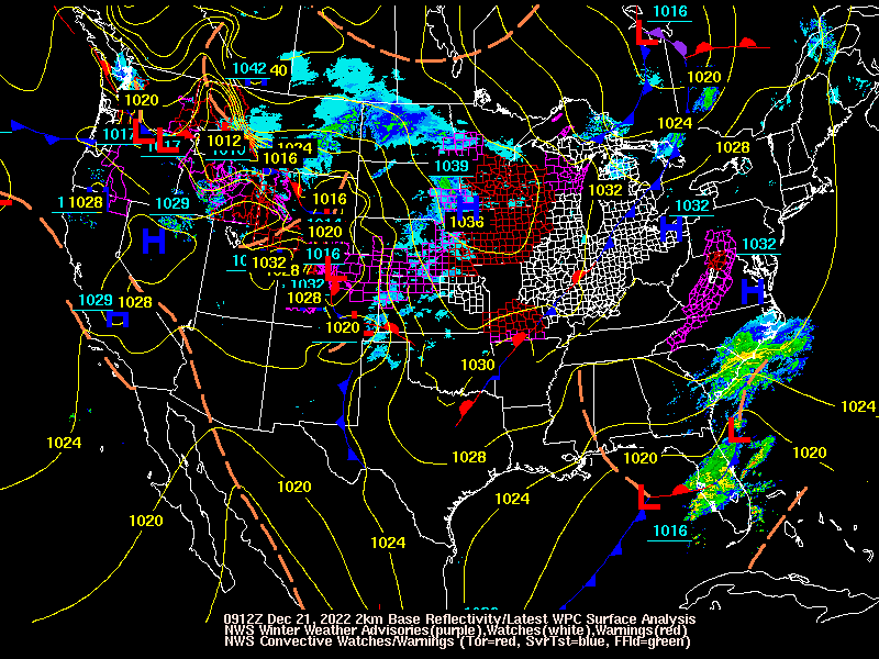
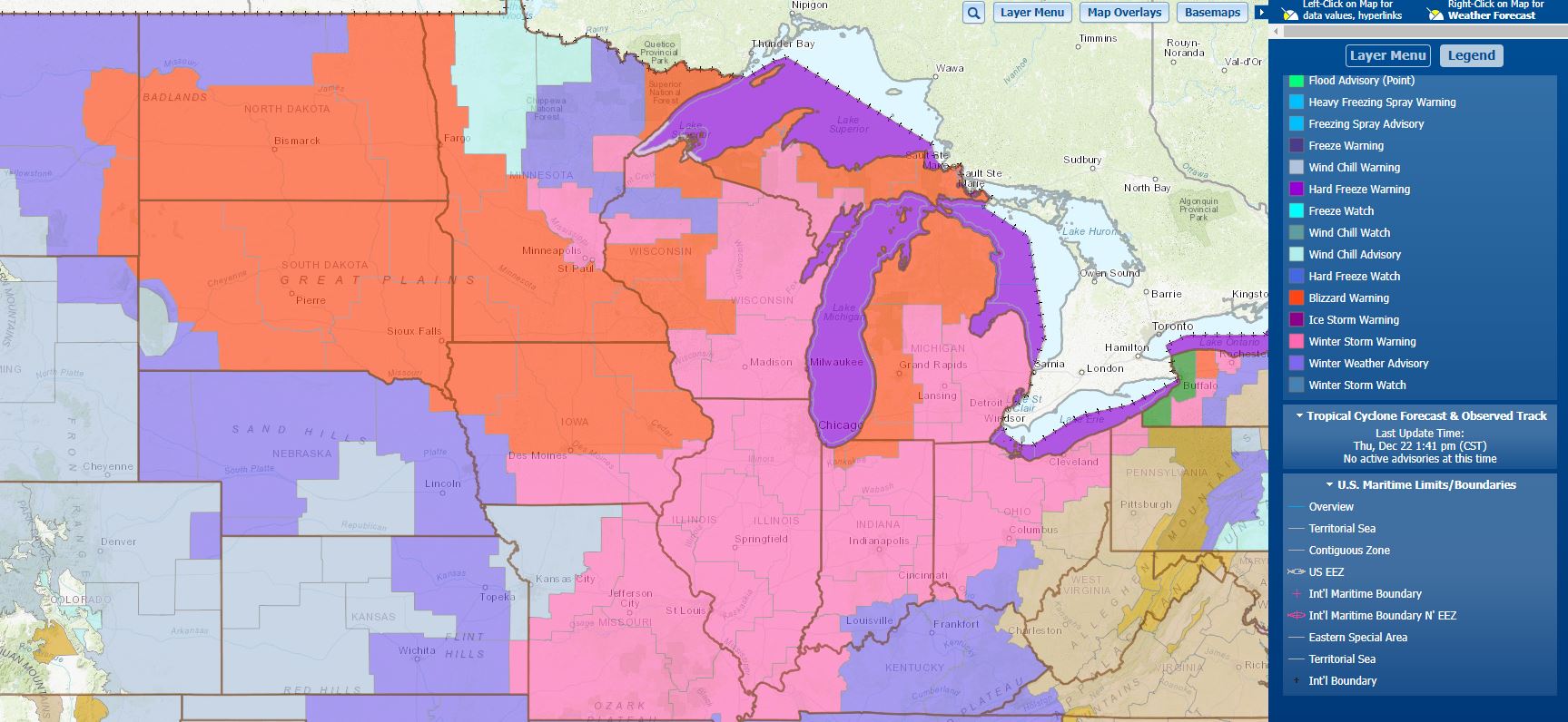
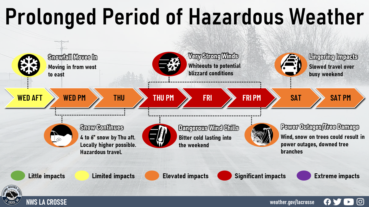
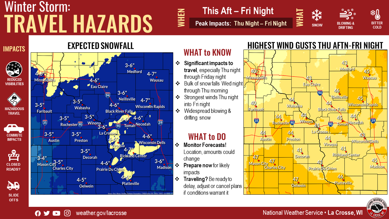
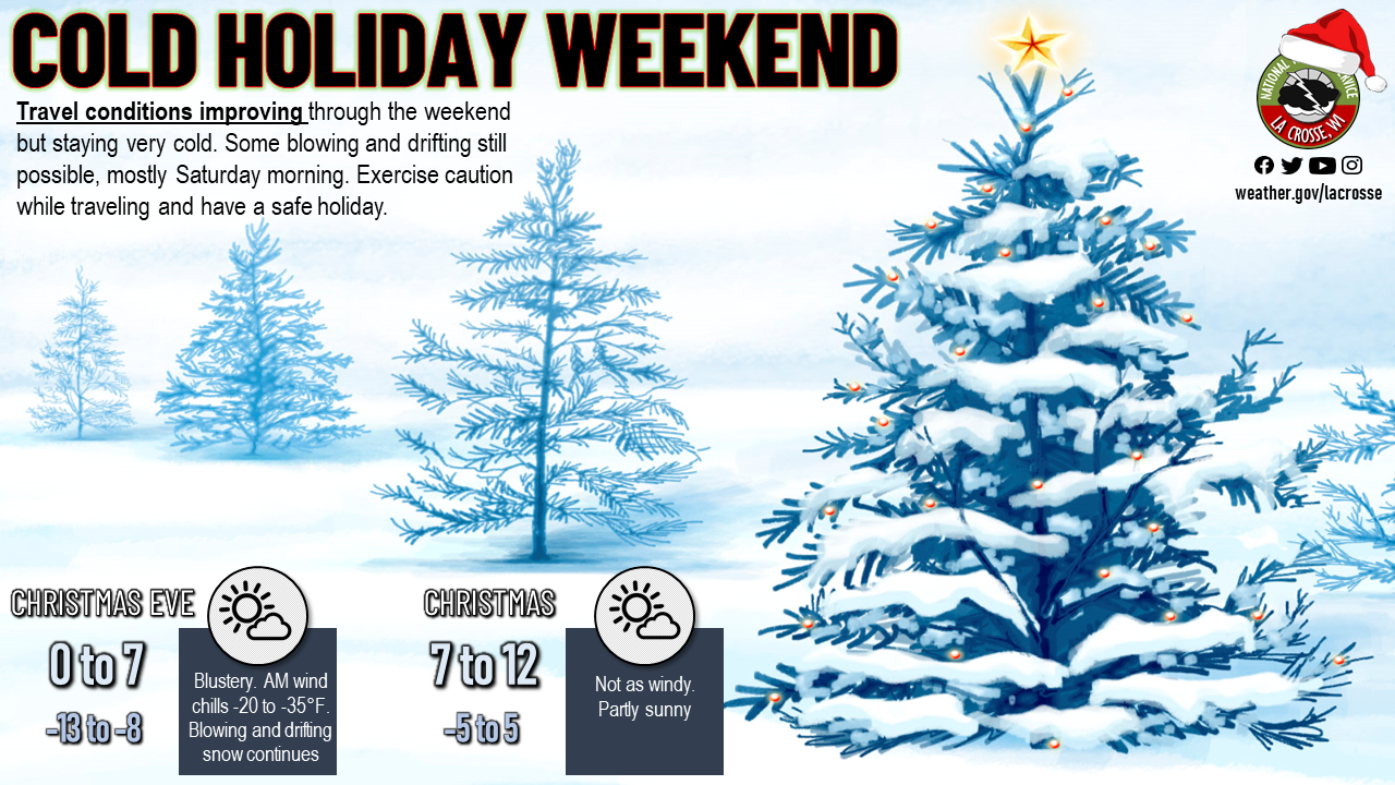
An unusually strong and slow moving storm system affected the Upper Mississippi Valley (and much of the U.S.!) from December 22-25 with snow, cold, strong winds and for some, blizzard conditions. The system first brought snowfall of 2-6 inches to the area Wednesday night into Thursday morning, followed by increasing winds. By Friday afternoon, blizzard conditions with whiteouts were occurring with wind gusts of 40 to 55 mph across much of southern Minnesota and Iowa, even into southwest Wisconsin. All of this combined with bitterly cold wind chills of -30 to -40F degrees to cause life threatening travel for stranded motorists. The cold persisted into Saturday (Christmas Eve), with the blowing and drifting snow slowly ramping down. But, the cold and brisk conditions continued into Christmas Day with wind chills in the -20 to -35F range. |
 Radar Loop of December 21 (3 pm) through 22nd (2 pm) 2022 |
Wind Gust Reports:
...HIGHEST WIND REPORTS FRIDAY AND FRIDAY NIGHT (DEC 23-24 2022)...

Location                     Speed     Time/Date       Lat/Lon

...Iowa...

...Chickasaw County...
New Hampton                  45 MPH    0230 PM 12/23   43.07N/92.46W

...Fayette County...
Oelwein Municipal Airport    47 MPH    0355 PM 12/23   42.68N/91.97W
Hawkeye                      44 MPH    0105 PM 12/23   42.96N/91.95W

...Floyd County...
Charles City Airport         49 MPH    1055 AM 12/23   43.07N/92.62W

...Howard County...
Saratoga                     45 MPH    1130 AM 12/23   43.35N/92.42W
Riceville                    40 MPH    0315 PM 12/23   43.36N/92.48W

...Winneshiek County...
Decorah Municipal Airport    41 MPH    0155 PM 12/23   43.27N/91.72W
Decorah                      40 MPH    0610 PM 12/23   43.25N/91.70W

...Minnesota...

...Dodge County...
U.s.14 - Byron - Mp 200      44 MPH    0335 PM 12/23   44.02N/92.71W
Dodge Center Airport         37 MPH    0415 AM 12/24   44.02N/92.82W

...Fillmore County...
U.s.63 - Le Roy - Mp 0.5     50 MPH    0125 PM 12/23   43.51N/92.37W
Preston Airport              39 MPH    1255 PM 12/23   43.68N/92.17W
T.h.52 - Canton - Mp 2       39 MPH    0925 PM 12/23   43.52N/91.89W

...Houston County...
Hokah                        35 MPH    0120 PM 12/23   43.80N/91.43W

...Mower County...
U.s.218 - Lyle - Mp 4        52 MPH    0115 PM 12/23   43.56N/92.95W
Austin Municipal Airport     46 MPH    0215 PM 12/23   43.67N/92.92W
I-90 - Dexter - Mp 195       45 MPH    1025 PM 12/23   43.73N/92.68W

...Olmsted County...
Rochester International Airp 48 MPH    1259 PM 12/23   43.90N/92.50W
U.s.63 - Stewartville - Mp 3 45 MPH    0650 PM 12/23   43.90N/92.48W
I-90 - Eyota - Mp 226        42 MPH    1240 AM 12/24   43.96N/92.21W
Mayo Helipad                 39 MPH    0135 PM 12/23   44.02N/92.48W
Byron                        38 MPH    1015 AM 12/23   44.04N/92.64W

...Wabasha County...
U.s.63 - Lake City - Mp 62.9 42 MPH    0645 PM 12/23   44.38N/92.37W
Lake City                    36 MPH    1143 AM 12/23   44.32N/92.44W

...Winona County...
I-90 - Ridgeway - Mp 261     40 MPH    1130 AM 12/23   43.91N/91.54W

...Wisconsin...

...Crawford County...
Prairie Du Chien  Airport    38 MPH    1255 PM 12/23   43.02N/91.12W

...Grant County...
Lancaster                    41 MPH    0241 PM 12/23   42.83N/90.69W
Boscobel Airport             40 MPH    0246 PM 12/23   43.15N/90.68W
Platteville Municipal Airpor 40 MPH    0315 PM 12/23   42.68N/90.43W

...Juneau County...
Necedah                      38 MPH    1248 PM 12/23   44.03N/90.08W

...La Crosse County...
La Crosse Regional Airport   40 MPH    0152 PM 12/23   43.88N/91.25W
Onalaska                     39 MPH    0346 AM 12/24   43.89N/91.18W
Snow/Ice
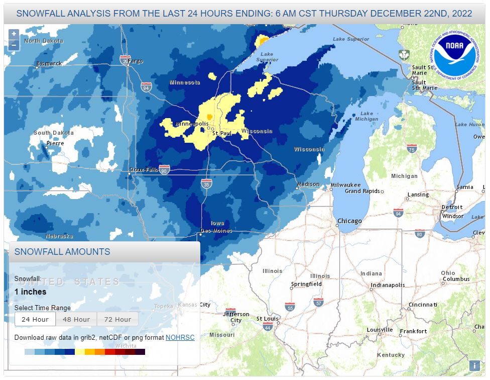 |
...STORM TOTAL SNOWFALL FROM DECEMBER 21-22 2022...
Location                     Amount    Time/Date       Lat/Lon

...Iowa...

...Allamakee County...
Monona 9.8 N                 2.5 in    0700 AM 12/22   43.19N/91.35W
Postville 5.5 NE             2.5 in    0700 AM 12/22   43.14N/91.49W

...Chickasaw County...
New Hampton                  3.0 in    0700 AM 12/22   43.06N/92.31W
New Hampton 0.4 SW           2.8 in    0700 AM 12/22   43.06N/92.32W
Fredericksburg 0.3 S         2.2 in    0800 AM 12/22   42.96N/92.20W

...Clayton County...
Guttenberg Dam 10            5.0 in    0800 AM 12/23   42.79N/91.10W
2 N Guttenberg               4.0 in    1230 PM 12/22   42.81N/91.10W
2 S Osterdock                3.5 in    1124 AM 12/22   42.70N/91.16W
Elkader 6SSW                 3.0 in    0700 AM 12/22   42.78N/91.45W
Elkader 6.8 WSW              2.9 in    0630 AM 12/22   42.81N/91.52W

...Fayette County...
Fayette                      3.8 in    0700 AM 12/23   42.88N/91.83W
Oelwein 1 E                  3.2 in    0630 AM 12/23   42.68N/91.88W

...Floyd County...
Nashua 2SW                   3.0 in    0700 AM 12/22   42.94N/92.57W
Nora Springs 2.4 SSE         2.0 in    0700 AM 12/22   43.11N/92.99W

...Mitchell County...
St Ansgar                    2.8 in    0630 AM 12/22   43.38N/92.92W
Osage                        2.0 in    0705 AM 12/22   43.28N/92.81W

...Winneshiek County...
6 N Frankville               4.0 in    0630 AM 12/22   43.28N/91.62W
Decorah 4.9SE                3.6 in    0700 AM 12/22   43.26N/91.70W
7 ENE Decorah                3.5 in    0814 AM 12/22   43.34N/91.64W
Calmar                       3.0 in    0700 AM 12/22   43.19N/91.86W

...Minnesota...

...Dodge County...
1 NE Kasson                  3.0 in    0723 AM 12/22   44.04N/92.74W
Kasson                       3.0 in    0725 AM 12/22   44.03N/92.75W
Mantorville 1.9 ESE          2.8 in    0700 AM 12/22   44.05N/92.72W
Hayfield 0.3 SSE             2.7 in    0400 AM 12/22   43.89N/92.85W

...Fillmore County...
Mabel                        2.8 in    0730 AM 12/22   43.52N/91.76W
Chatfield 9.0 ESE            2.7 in    0700 AM 12/22   43.79N/92.03W
Wykoff 3.1 NW                2.5 in    0700 AM 12/22   43.74N/92.31W
Spring Valley                2.4 in    0700 AM 12/22   43.69N/92.39W
Lanesboro 0.2 SSW            2.2 in    0600 AM 12/22   43.72N/91.97W

...Houston County...
3 WSW La Crescent            4.0 in    0828 AM 12/22   43.81N/91.37W
Caledonia                    3.7 in    0730 AM 12/22   43.63N/91.50W
3 ENE Mound Prairie          3.3 in    0613 AM 12/22   43.80N/91.41W
1 ENE Mound Prairie          3.3 in    0630 AM 12/22   43.79N/91.42W
Hokah 4 NW                   3.3 in    0700 AM 12/22   43.80N/91.43W

...Mower County...
Waltham 2.0 SE               2.5 in    0800 AM 12/22   43.80N/92.85W
Austin                       3.0 in    0128 AM 12/22   43.67N/92.97W
Austin 2.4 W                 2.1 in    0700 AM 12/22   43.67N/93.02W

...Olmsted County...
Dover                        4.0 in    0943 AM 12/22   43.97N/92.14W
Rochester 1.5 WSW            4.0 in    0600 AM 12/22   44.00N/92.50W
Elgin 2SSW                   4.0 in    0700 AM 12/22   44.10N/92.27W
2 S Predmore                 3.8 in    1027 AM 12/22   43.90N/92.34W
Stewartville 4.3 E           3.5 in    0600 AM 12/22   43.86N/92.40W
1 SSW Oronoco                3.4 in    1035 AM 12/22   44.15N/92.54W
Rochester AP 2NE             3.4 in    0700 AM 12/23   43.93N/92.48W
2 NNW Rochester              3.2 in    0700 AM 12/22   44.05N/92.49W
3 SE Rochester               3.1 in    0759 AM 12/22   43.98N/92.44W
2 NE Rochester               3.0 in    0530 AM 12/22   44.04N/92.44W
Rochester 4.7 N              4.0 in    0700 AM 12/23   44.08N/92.48W
Elba 4.7 SW                  2.8 in    0800 AM 12/22   44.04N/92.09W
2 NNE Rochester              2.7 in    0430 AM 12/22   44.04N/92.46W
Rochester 5.7 N              2.6 in    0730 AM 12/22   44.10N/92.46W
3 SE Douglas                 2.5 in    0830 AM 12/22   44.08N/92.53W
Chatfield                    2.5 in    0942 AM 12/22   43.85N/92.19W
Rochester 4.2 N              2.0 in    0600 AM 12/22   44.08N/92.49W

...Wabasha County...
Lake City                    5.0 in    0700 AM 12/23   44.44N/92.28W
Wabsha                       4.6 in    0730 AM 12/23   44.39N/92.06W
Theilman 1 SSW               4.6 in    0730 AM 12/22   44.28N/92.19W
3 W Theilman                 4.0 in    0606 AM 12/22   44.28N/92.24W
Zumbro Falls 3.5 SSW         3.7 in    0800 AM 12/22   44.24N/92.46W
Wabasha 6.2 WNW              3.5 in    0700 AM 12/22   44.39N/92.16W

...Winona County...
Winona Dam 5                 5.0 in.   0700 AM 12/23   44.09N/91.67W
Winona 2.0 ESE               3.6 in    0700 AM 12/22   44.04N/91.63W
2 NNW Wilson                 3.5 in    0902 AM 12/22   43.98N/91.71W
La Crescent 4.0 NNW          3.4 in    0700 AM 12/22   43.88N/91.34W
Winona 1.9 ESE               3.3 in    0752 AM 12/22   44.04N/91.63W
4.2 N Rollingstone           3.0 in    0800 AM 12/22   44.16N/91.81W

...Wisconsin...

...Adams County...
9 ENE Friendship             5.5 in    0953 AM 12/22   44.01N/89.66W
Nekoosa 8.0 SSE              3.0 in    0700 AM 12/22   44.21N/89.85W
0.6 W Friendship             2.2 in    0700 AM 12/22   43.98N/89.83W

...Buffalo County...
Mondovi                      5.7 in    0455 PM 12/22   44.56N/91.67W
Cochrane                     3.9 in    1000 AM 12/22   44.22N/91.84W
Mondovi 12.1 SSE             3.5 in    0630 AM 12/22   44.40N/91.60W

...Clark County...
Owen 1 ESE                   5.0 in    0700 AM 12/23   44.95N/90.55W
6 N Chili                    4.0 in    0947 AM 12/22   44.71N/90.34W

...Crawford County...
1 S De Soto                  4.6 in    0754 AM 12/23   43.41N/91.19W
Gays Mills 1.0 NE            3.0 in    0700 AM 12/23   43.33N/90.84W
Steuben 4SE                  3.0 in    0720 AM 12/23   43.13N/90.84W
2 N Prairie Du Chien         2.6 in    1209 PM 12/22   43.07N/91.14W

...Grant County...
2 SE Blue River              6.0 in    1100 AM 12/22   43.17N/90.55W
2 SE Blue River              5.5 in    1035 AM 12/22   43.17N/90.55W
Sinsinawa                    5.0 in    1100 AM 12/22   42.52N/90.54W
Beetown                      4.5 in    0450 PM 12/22   42.80N/90.89W
2 N Glen Haven               4.0 in    0900 AM 12/22   42.86N/91.07W
1 WNW Platteville            4.0 in    0415 PM 12/22   42.74N/90.49W
Cassville 7.8 ENE            3.5 in    0700 AM 12/22   42.75N/90.84W
Muscoda 0.5 WSW              3.4 in    0855 AM 12/22   43.18N/90.44W
4.3 W Lancaster              3.0 in    0800 AM 12/22   42.83N/90.79W

...Jackson County...
Melrose 3.6 W                4.5 in    0700 AM 12/22   44.13N/91.07W
9 E Pray                     4.0 in    0630 AM 12/22   44.35N/90.33W
5 E Black River Falls        3.5 in    0630 AM 12/22   44.30N/90.75W
Black River Falls            3.3 in    0830 AM 12/22   44.29N/90.85W

...Juneau County...
Mauston                      4.0 in    0829 AM 12/23   43.80N/90.08W
1.0 E Mauston                3.6 in    0800 AM 12/23   43.79N/90.06W
3 E Necedah                  3.0 in    1130 AM 12/22   44.03N/90.01W
Union Center                 3.0 in    0502 AM 12/22   43.68N/90.26W

...La Crosse County...
2 E La Crosse                3.7 in    0600 AM 12/23   43.82N/91.19W
Holmen 2 S                   3.5 in    0700 AM 12/23   43.93N/91.25W
Onalaska 1.9 E               3.5 in    0700 AM 12/23   43.89N/91.18W
French Island                3.3 in    0600 AM 12/23   43.86N/91.27W
La Crosse 4NNW               3.1 in    0730 AM 12/23   43.87N/91.27W
West Salem                   3.0 in    0700 AM 12/23   43.90N/91.09W
West Salem 0.7 W             3.0 in    0700 AM 12/23   43.90N/91.10W
Holmen                       3.0 in    0409 AM 12/23   43.96N/91.26W
4 NE New Amsterdam           3.0 in    0745 AM 12/23   44.03N/91.27W
Coon Valley 4.5 NNW          2.8 in    0700 AM 12/23   43.76N/91.06W

...Monroe County...
1 S Tomah                    4.4 in    0820 AM 12/23   43.98N/90.50W
Cashton 3 NNW                4.2 in    0746 AM 12/23   43.79N/90.80W
1 SSW Tomah                  4.0 in    0605 AM 12/22   43.97N/90.52W
3 NNE Tunnel City            3.5 in    0108 PM 12/22   44.04N/90.55W
Warrens                      3.0 in    0630 AM 12/22   44.13N/90.50W
2 NNW Tomah                  3.0 in    1219 PM 12/22   44.01N/90.51W
0.5 SW Sparta                3.0 in    0800 AM 12/22   43.94N/90.82W
Warrens 4.7 WSW              2.9 in    0700 AM 12/22   44.10N/90.59W

...Richland County...
Richland Center 4 N          3.0 in    0700 AM 12/22   43.40N/90.39W
Richland Center 4.0 N        3.0 in    0800 AM 12/22   43.40N/90.39W

...Taylor County...
Medford 0.8 ENE              4.4 in    0700 AM 12/22   45.14N/90.33W
2 N Dorchester               4.2 in    1001 AM 12/22   45.04N/90.34W
6 NNW Curtiss                4.0 in    0145 AM 12/22   45.04N/90.49W

...Trempealeau County...
Ettrick 4.0 WNW              4.5 in    0755 AM 12/22   44.19N/91.34W
Arcadia                      4.5 in    0854 AM 12/22   44.25N/91.49W
1 NNW Galesville             4.0 in    0900 AM 12/22   44.09N/91.36W
Trempealeau                  4.0 in    1100 AM 12/22   44.01N/91.44W
3 SSE Elk Creek              4.0 in    0430 AM 12/22   44.39N/91.38W
4 NW Stevenstown             3.4 in    0819 AM 12/22   44.07N/91.23W
Galesville                   3.0 in    0150 AM 12/22   44.08N/91.36W

...Vernon County...
La Farge                     4.5 in    0700 AM 12/23   43.57N/90.63W
Hillsboro 2 SW               3.8 in    0700 AM 12/22   43.63N/90.38W
La Farge                     3.5 in    0900 AM 12/22   43.58N/90.64W
Westby                       3.5 in    0930 AM 12/22   43.66N/90.86W
Stoddard 4.7 NNE             2.7 in    0700 AM 12/23   43.72N/91.17W
Viroqua                      2.5 in    0135 AM 12/23   43.56N/90.89W
2 NE Stoddard                2.4 in    0900 AM 12/23   43.68N/91.19W
0.5 E Viroqua                2.4 in    0700 AM 12/22   43.56N/90.88W
Stoddard 1.5 NE              2.4 in    0730 AM 12/22   43.67N/91.19W
Viroqua 0.8 ESE              2.2 in    0700 AM 12/23   43.55N/90.87W
Wind Chill Reports
Wind Chill Reports:
[Lowest as of Saturday Morning Dec 24]
[Lowest Saturday Night Through Sunday Dec 25]
Coldest Wind Chill Reports Through Friday Morning (Dec 23)
Location                     WC Temp.  Time/Date       Lat/Lon

...Iowa...

...Chickasaw County...
New Hampton                  -41 F     0340 AM 12/23   43.07N/92.46W
New Hampton                  -39 F     0529 AM 12/23   43.05N/92.30W
New Hampton                  -39 F     0445 AM 12/23   43.06N/92.32W

...Clayton County...
Monona                       -43 F     0644 AM 12/23   43.04N/91.39W
Mcgregor                     -33 F     0604 AM 12/23   43.02N/91.19W

...Fayette County...
Oelwein Municipal Airport    -42 F     0255 AM 12/23   42.68N/91.97W
Hawkeye                      -41 F     0725 PM 12/22   42.96N/91.95W

...Floyd County...
Charles City Airport         -41 F     0415 AM 12/23   43.07N/92.62W
2 NE Dougherty               -38 F     0600 AM 12/23   42.95N/93.01W
Charles City                 -36 F     0148 AM 12/23   43.05N/92.67W

...Howard County...
Saratoga                     -41 F     0130 AM 12/23   43.35N/92.42W
Saratoga                     -41 F     0625 AM 12/23   43.37N/92.47W
Riceville                    -37 F     0630 AM 12/23   43.36N/92.48W

...Mitchell County...
St.Ansgar                    -36 F     0645 AM 12/23   43.38N/92.92W
Stacyville                   -35 F     0640 AM 12/23   43.44N/92.78W

...Winneshiek County...
1 ENE Jackson Junction       -41 F     0735 PM 12/22   43.11N/92.04W
Decorah                      -40 F     1125 PM 12/22   43.30N/91.79W
Decorah                      -40 F     0615 AM 12/23   43.25N/91.70W
Decorah Municipal Airport    -36 F     0415 AM 12/23   43.27N/91.72W
Calmar                       -33 F     0110 AM 12/23   43.25N/91.82W

...Minnesota...

...Dodge County...
U.s.14 - Byron - Mp 200      -45 F     0415 AM 12/23   44.02N/92.71W
Dodge Center Airport         -43 F     0855 PM 12/22   44.02N/92.82W
Hayfield                     -31 F     0537 AM 12/23   43.89N/92.85W

...Fillmore County...
T.h.52 - Canton - Mp 2       -43 F     0850 PM 12/22   43.52N/91.89W
Preston Airport              -42 F     0335 AM 12/23   43.68N/92.17W
U.s.63 - Le Roy - Mp 0.5     -42 F     0640 AM 12/23   43.51N/92.37W
Lanesboro                    -35 F     0320 AM 12/23   43.65N/91.84W

...Houston County...
Hokah                        -30 F     0640 AM 12/23   43.80N/91.43W
Houston                      -28 F     1218 AM 12/23   43.77N/91.58W
T.h.44 - Hokah - Mp 60       -25 F     0640 AM 12/23   43.72N/91.44W

...Mower County...
I-90 - Dexter - Mp 195       -45 F     0525 AM 12/23   43.73N/92.68W
U.s.218 - Lyle - Mp 4        -42 F     0540 AM 12/23   43.56N/92.95W
Austin Municipal Airport     -39 F     0355 AM 12/23   43.67N/92.92W
Austin                       -37 F     0925 PM 12/22   43.65N/93.00W

...Olmsted County...
I-90 - Eyota - Mp 226        -47 F     0335 AM 12/23   43.96N/92.21W
U.s.63 - Stewartville - Mp 3 -46 F     0650 PM 12/22   43.90N/92.48W
Rochester International Airp -44 F     0204 AM 12/23   43.90N/92.50W
Byron                        -37 F     0515 AM 12/23   44.04N/92.64W
Mayo Helipad                 -36 F     0815 PM 12/22   44.02N/92.48W
Rochester                    -30 F     0650 AM 12/23   44.05N/92.45W
Rochester                    -29 F     0355 AM 12/23   44.09N/92.51W
Rochester                    -29 F     1115 PM 12/22   44.18N/92.41W
Rochester                    -26 F     0605 AM 12/23   44.09N/92.49W
Rochester                    -26 F     0320 AM 12/23   44.05N/92.53W
Rochester                    -25 F     0831 PM 12/22   44.04N/92.44W

...Wabasha County...
U.s.63 - Lake City - Mp 62.9 -43 F     0610 AM 12/23   44.38N/92.37W
Lake City                    -39 F     0803 PM 12/22   44.32N/92.44W
Lake City                    -27 F     0600 AM 12/23   44.44N/92.28W

...Winona County...
I-90 - Ridgeway - Mp 261     -45 F     0620 AM 12/23   43.91N/91.54W
1 ESE Winona                 -33 F     0635 AM 12/23   44.04N/91.63W
Winona Municipal Airport     -33 F     0415 AM 12/23   44.07N/91.70W
I-90 - La Crescent - Mp 276. -33 F     0620 AM 12/23   43.86N/91.30W
U.s.61 - Winona              -30 F     1135 PM 12/22   43.98N/91.43W
La Crescent 4.0 NNW          -25 F     0512 AM 12/23   43.88N/91.34W

...Wisconsin...

...Adams County...
Grand Marsh                  -38 F     0625 AM 12/23   43.89N/89.68W

...Crawford County...
Prairie Du Chien  Airport    -36 F     0655 PM 12/22   43.02N/91.12W

...Grant County...
Fennimore                    -39 F     0545 AM 12/23   42.98N/90.66W
Lancaster                    -39 F     0941 PM 12/22   42.83N/90.69W
Platteville Municipal Airpor -37 F     0235 AM 12/23   42.68N/90.43W
Boscobel                     -31 F     0603 AM 12/23   43.15N/90.68W
Platteville                  -31 F     0616 AM 12/23   42.74N/90.46W
Boscobel Airport             -31 F     1153 PM 12/22   43.15N/90.68W
Lancaster                    -31 F     0600 AM 12/23   42.83N/90.79W

...Jackson County...
Black River Falls Area Airpo -33 F     0535 AM 12/23   44.25N/90.85W
1 E Black River Falls        -32 F     0515 AM 12/23   44.30N/90.73W

...Juneau County...
Volk Field                   -41 F     0124 AM 12/23   43.92N/90.27W
Mauston Airport              -36 F     0615 AM 12/23   43.83N/90.13W
Necedah                      -35 F     0548 AM 12/23   44.03N/90.08W

...La Crosse County...
La Crosse Regional Airport   -36 F     0553 AM 12/23   43.88N/91.25W
Holmen                       -35 F     0530 AM 12/23   43.96N/91.23W
Onalaska                     -34 F     0646 AM 12/23   43.89N/91.18W
La Crosse                    -30 F     0208 AM 12/23   43.82N/91.19W
Burns                        -29 F     1213 AM 12/23   43.91N/90.97W
La Crosse                    -28 F     0215 AM 12/23   43.77N/91.22W
La Crosse                    -26 F     0138 AM 12/23   43.81N/91.25W

...Monroe County...
Millston                     -36 F     0415 AM 12/23   44.15N/90.69W
Tomah                        -34 F     0145 AM 12/23   43.99N/90.67W

...Richland County...
1 SSE Richland Center        -35 F     0609 AM 12/23   43.32N/90.38W
Soldiers Grove               -33 F     0405 AM 12/23   43.35N/90.60W

...Taylor County...
Westboro                     -30 F     0645 AM 12/23   45.37N/90.31W

...Trempealeau County...
Trempealeau                  -33 F     0637 AM 12/23   44.07N/91.51W

...Vernon County...
Viroqua Municipal Airport    -40 F     0135 AM 12/23   43.58N/90.90W
Hillsboro                    -37 F     0510 AM 12/23   43.68N/90.43W
La Farge                     -26 F     0630 AM 12/23   43.60N/90.63W

Observations are collected from a variety of sources with varying
equipment and exposures. We thank all volunteer weather observers
for their dedication. Not all data listed are considered official.
Coldest Wind Chill Reports: 24 hours Ending Saturday Morning (Dec 24)

Location                     WC Temp.  Time/Date       Lat/Lon

...Iowa...

...Chickasaw County...
New Hampton                  -40 F     0819 AM 12/23   43.05N/92.30W
New Hampton                  -39 F     0810 AM 12/23   43.06N/92.32W

...Clayton County...
Monona                       -44 F     0824 AM 12/23   43.04N/91.39W
Mcgregor                     -32 F     0809 AM 12/23   43.02N/91.19W

...Fayette County...
Hawkeye                      -39 F     0840 AM 12/23   42.96N/91.95W
Oelwein Municipal Airport    -39 F     0955 AM 12/23   42.68N/91.97W

...Floyd County...
Charles City Airport         -38 F     0855 AM 12/23   43.07N/92.62W
2 NE Dougherty               -37 F     0805 AM 12/23   42.95N/93.01W
Charles City                 -35 F     0749 AM 12/23   43.05N/92.67W

...Howard County...
Saratoga                     -41 F     0745 AM 12/23   43.37N/92.47W
Saratoga                     -40 F     0815 AM 12/23   43.35N/92.42W
Riceville                    -35 F     0745 AM 12/23   43.36N/92.48W

...Mitchell County...
St.Ansgar                    -35 F     0740 AM 12/23   43.38N/92.92W
Stacyville                   -31 F     0447 PM 12/23   43.44N/92.78W

...Winneshiek County...
1 ENE Jackson Junction       -40 F     0835 AM 12/23   43.11N/92.04W
Decorah                      -38 F     0940 AM 12/23   43.25N/91.70W
Decorah                      -37 F     0850 AM 12/23   43.30N/91.79W
Decorah Municipal Airport    -33 F     1115 AM 12/23   43.27N/91.72W
Calmar                       -26 F     0935 AM 12/23   43.25N/91.82W

...Minnesota...

...Dodge County...
U.s.14 - Byron - Mp 200      -44 F     0825 AM 12/23   44.02N/92.71W
Dodge Center Airport         -37 F     0915 AM 12/23   44.02N/92.82W
Hayfield                     -32 F     0757 AM 12/23   43.89N/92.85W

...Fillmore County...
T.h.52 - Canton - Mp 2       -44 F     0740 AM 12/23   43.52N/91.89W
Preston Airport              -43 F     0755 AM 12/23   43.68N/92.17W
U.s.63 - Le Roy - Mp 0.5     -42 F     0750 AM 12/23   43.51N/92.37W
Lanesboro                    -33 F     0945 AM 12/23   43.65N/91.84W

...Houston County...
Hokah                        -27 F     0920 AM 12/23   43.80N/91.43W
Houston                      -26 F     0849 AM 12/23   43.77N/91.58W
T.h.44 - Hokah - Mp 60       -25 F     0940 AM 12/23   43.72N/91.44W

...Mower County...
I-90 - Dexter - Mp 195       -43 F     0850 AM 12/23   43.73N/92.68W
U.s.218 - Lyle - Mp 4        -41 F     0755 AM 12/23   43.56N/92.95W
Austin Municipal Airport     -37 F     1057 AM 12/23   43.67N/92.92W
Austin                       -33 F     0747 AM 12/23   43.65N/93.00W

...Olmsted County...
I-90 - Eyota - Mp 226        -45 F     0830 AM 12/23   43.96N/92.21W
U.s.63 - Stewartville - Mp 3 -44 F     0900 AM 12/23   43.90N/92.48W
Rochester International Airp -43 F     0819 AM 12/23   43.90N/92.50W
Byron                        -36 F     0946 AM 12/23   44.04N/92.64W
Mayo Helipad                 -35 F     0815 AM 12/23   44.02N/92.48W
3 N Stewartville             -32 F     0700 AM 12/24   43.90N/92.48W
Rochester                    -30 F     0820 AM 12/23   44.05N/92.45W

...Wabasha County...
U.s.63 - Lake City - Mp 62.9 -42 F     0805 AM 12/23   44.38N/92.37W
Lake City                    -37 F     0903 AM 12/23   44.32N/92.44W

...Winona County...
I-90 - Ridgeway - Mp 261     -44 F     0905 AM 12/23   43.91N/91.54W
Winona Municipal Airport     -33 F     0815 AM 12/23   44.07N/91.70W
I-90 - La Crescent - Mp 276. -33 F     0930 AM 12/23   43.86N/91.30W
1 ESE Winona                 -31 F     0835 AM 12/23   44.04N/91.63W
U.s.61 - Winona              -29 F     0950 AM 12/23   43.98N/91.43W
La Crescent 4.0 NNW          -26 F     0932 AM 12/23   43.88N/91.34W

...Wisconsin...

...Adams County...
Grand Marsh                  -37 F     0840 AM 12/23   43.89N/89.68W

...Crawford County...
Prairie Du Chien  Airport    -30 F     0155 PM 12/23   43.02N/91.12W
De Soto                      -22 F     0901 AM 12/23   43.42N/91.19W

...Grant County...
Fennimore                    -38 F     0745 AM 12/23   42.98N/90.66W
Platteville Municipal Airpor -37 F     0815 AM 12/23   42.68N/90.43W
Lancaster                    -36 F     0841 AM 12/23   42.83N/90.69W
Platteville                  -33 F     0745 AM 12/23   42.74N/90.46W
Boscobel Airport             -29 F     0853 AM 12/23   43.15N/90.68W
Boscobel                     -28 F     0903 AM 12/23   43.15N/90.68W

...Jackson County...
Black River Falls Area Airpo -33 F     0915 AM 12/23   44.25N/90.85W
1 E Black River Falls        -30 F     0815 AM 12/23   44.30N/90.73W

...Juneau County...
Necedah                      -37 F     0748 AM 12/23   44.03N/90.08W
Mauston Airport              -36 F     0915 AM 12/23   43.83N/90.13W

...La Crosse County...
Holmen                       -36 F     0910 AM 12/23   43.96N/91.23W
La Crosse Regional Airport   -35 F     0753 AM 12/23   43.88N/91.25W
Onalaska                     -33 F     0836 AM 12/23   43.89N/91.18W
La Crosse                    -31 F     0708 AM 12/23   43.82N/91.19W
Burns                        -29 F     0758 AM 12/23   43.91N/90.97W
La Crosse                    -28 F     0945 AM 12/23   43.77N/91.22W

...Monroe County...
Millston                     -38 F     0815 AM 12/23   44.15N/90.69W
Tomah                        -34 F     1005 AM 12/23   43.99N/90.67W

...Richland County...
1 SSE Richland Center        -35 F     0944 AM 12/23   43.32N/90.38W
Soldiers Grove               -33 F     0800 AM 12/23   43.35N/90.60W

...Taylor County...
Westboro                     -32 F     0810 AM 12/23   45.37N/90.31W

...Trempealeau County...
Trempealeau                  -34 F     0738 AM 12/23   44.07N/91.51W

...Vernon County...
Viroqua Municipal Airport    -38 F     0835 AM 12/23   43.58N/90.90W
Hillsboro                    -35 F     0745 AM 12/23   43.68N/90.43W
La Farge                     -26 F     1045 AM 12/23   43.60N/90.63W
Coldest Wind Chill Reports: 24 hours Saturday Night Through Sunday (Dec 25)
Location                     WC Temp.  Time/Date       Lat/Lon

...Iowa...

...Chickasaw County...
New Hampton                  -24 F     0649 AM 12/25   43.05N/92.30W

...Clayton County...
Monona                       -27 F     0724 AM 12/25   43.04N/91.39W
Mcgregor                     -15 F     0829 AM 12/25   43.02N/91.19W

...Fayette County...
Hawkeye                      -23 F     0630 AM 12/25   42.96N/91.95W
Oelwein Municipal Airport    -23 F     0715 AM 12/25   42.68N/91.97W

...Floyd County...
Charles City Airport         -22 F     0635 AM 12/25   43.07N/92.62W
2 NE Dougherty               -21 F     0805 AM 12/25   42.95N/93.01W
Charles City                 -17 F     0649 AM 12/25   43.05N/92.67W

...Howard County...
Saratoga                     -27 F     0631 AM 12/25   43.35N/92.42W
Riceville                    -22 F     0616 AM 12/25   43.36N/92.48W

...Mitchell County...
Stacyville                   -20 F     0559 AM 12/25   43.44N/92.78W
St.Ansgar                    -20 F     0626 AM 12/25   43.38N/92.92W

...Winneshiek County...
1 ENE Jackson Junction       -23 F     0705 AM 12/25   43.11N/92.04W
Decorah Municipal Airport    -18 F     0655 AM 12/25   43.27N/91.72W

...Minnesota...

...Dodge County...
U.s.14 - Byron - Mp 200      -32 F     0600 AM 12/25   44.02N/92.71W
Dodge Center Airport         -28 F     0635 AM 12/25   44.02N/92.82W
Hayfield                     -15 F     0627 AM 12/25   43.89N/92.85W

...Fillmore County...
Preston Airport              -29 F     0655 AM 12/25   43.68N/92.17W
U.s.63 - Le Roy - Mp 0.5     -29 F     0705 AM 12/25   43.51N/92.37W
T.h.52 - Canton - Mp 2       -28 F     0735 AM 12/25   43.52N/91.89W

...Houston County...
Hokah                        -15 F     0620 AM 12/25   43.80N/91.43W
T.h.44 - Hokah - Mp 60       -14 F     0640 AM 12/25   43.72N/91.44W
Houston                      -11 F     0747 AM 12/25   43.77N/91.58W

...Mower County...
I-90 - Dexter - Mp 195       -32 F     0610 AM 12/25   43.73N/92.68W
U.s.218 - Lyle - Mp 4        -28 F     0600 AM 12/25   43.56N/92.95W
Austin Municipal Airport     -25 F     0717 AM 12/25   43.67N/92.92W
Austin                       -19 F     0816 AM 12/25   43.65N/93.00W

...Olmsted County...
U.s.63 - Stewartville - Mp 3 -32 F     0615 AM 12/25   43.90N/92.48W
I-90 - Eyota - Mp 226        -32 F     0640 AM 12/25   43.96N/92.21W
Rochester International Airp -29 F     0654 AM 12/25   43.90N/92.50W
Mayo Helipad                 -24 F     0635 AM 12/25   44.02N/92.48W
Byron                        -23 F     0645 AM 12/25   44.04N/92.64W

...Wabasha County...
U.s.63 - Lake City - Mp 62.9 -27 F     0610 AM 12/25   44.38N/92.37W
Lake City                    -27 F     0623 AM 12/25   44.32N/92.44W
Lake City                    -17 F     0600 AM 12/25   44.44N/92.28W
Plainview                    -10 F     0405 AM 12/25   44.17N/92.17W

...Winona County...
I-90 - Ridgeway - Mp 261     -33 F     0650 AM 12/25   43.91N/91.54W
1 ESE Winona                 -19 F     0730 AM 12/25   44.04N/91.63W
Winona Municipal Airport     -18 F     0715 AM 12/25   44.07N/91.70W
U.s.61 - Winona              -15 F     0630 AM 12/25   43.98N/91.43W
I-90 - La Crescent - Mp 276. -15 F     0645 AM 12/25   43.86N/91.30W
La Crescent 4.0 NNW          -11 F     0623 AM 12/25   43.88N/91.34W

...Wisconsin...

...Adams County...
Grand Marsh                  -22 F     0845 AM 12/25   43.89N/89.68W

...Crawford County...
Prairie Du Chien  Airport    -19 F     0635 AM 12/25   43.02N/91.12W
De Soto                       -9 F     0726 AM 12/25   43.42N/91.19W

...Grant County...
Lancaster                    -20 F     0641 AM 12/25   42.83N/90.69W
Fennimore                    -20 F     0720 AM 12/25   42.98N/90.66W
Platteville Municipal Airpor -20 F     0735 AM 12/25   42.68N/90.43W
Boscobel Airport             -12 F     0653 AM 12/25   43.15N/90.68W

...Jackson County...
Black River Falls Area Airpo -20 F     0635 AM 12/25   44.25N/90.85W
1 E Black River Falls        -18 F     0515 AM 12/25   44.30N/90.73W
North Bend                    47 F     0400 AM 12/25   44.10N/91.11W

...Juneau County...
Mauston Airport              -24 F     0715 AM 12/25   43.83N/90.13W
Necedah                      -21 F     0748 AM 12/25   44.03N/90.08W
New Lisbon                   -15 F     0845 AM 12/25   43.87N/90.17W

...La Crosse County...
Onalaska                     -21 F     0656 AM 12/25   43.89N/91.18W
La Crosse Regional Airport   -19 F     0653 AM 12/25   43.88N/91.25W
Burns                        -17 F     0739 AM 12/25   43.91N/90.97W

...Monroe County...
Millston                     -22 F     0845 AM 12/25   44.15N/90.69W
Tomah                        -18 F     0655 AM 12/25   43.99N/90.67W

...Richland County...
1 SSE Richland Center        -20 F     0719 AM 12/25   43.32N/90.38W
Soldiers Grove               -15 F     0720 AM 12/25   43.35N/90.60W

...Taylor County...
Medford                      -15 F     0715 AM 12/25   45.30N/90.30W
Westboro                     -14 F     0705 AM 12/25   45.37N/90.31W

...Trempealeau County...
Trempealeau                  -23 F     0656 AM 12/25   44.07N/91.51W

...Vernon County...
Viroqua Municipal Airport    -25 F     0555 AM 12/25   43.58N/90.90W
Hillsboro                    -22 F     0720 AM 12/25   43.68N/90.43W
La Farge                      -9 F     0831 AM 12/25   43.60N/90.63W
Photos & Video:
Header
 |
 |
 |
 |
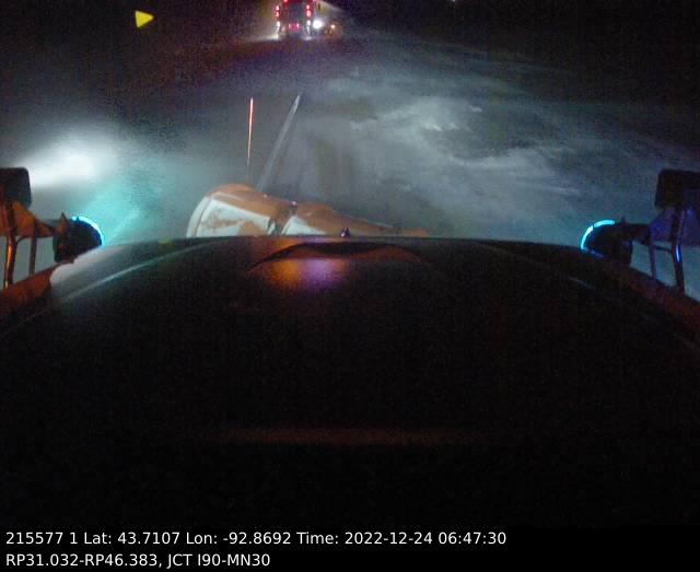
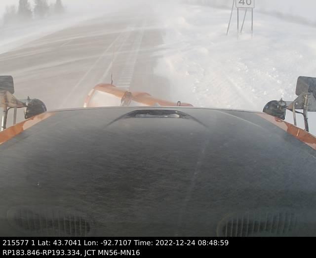
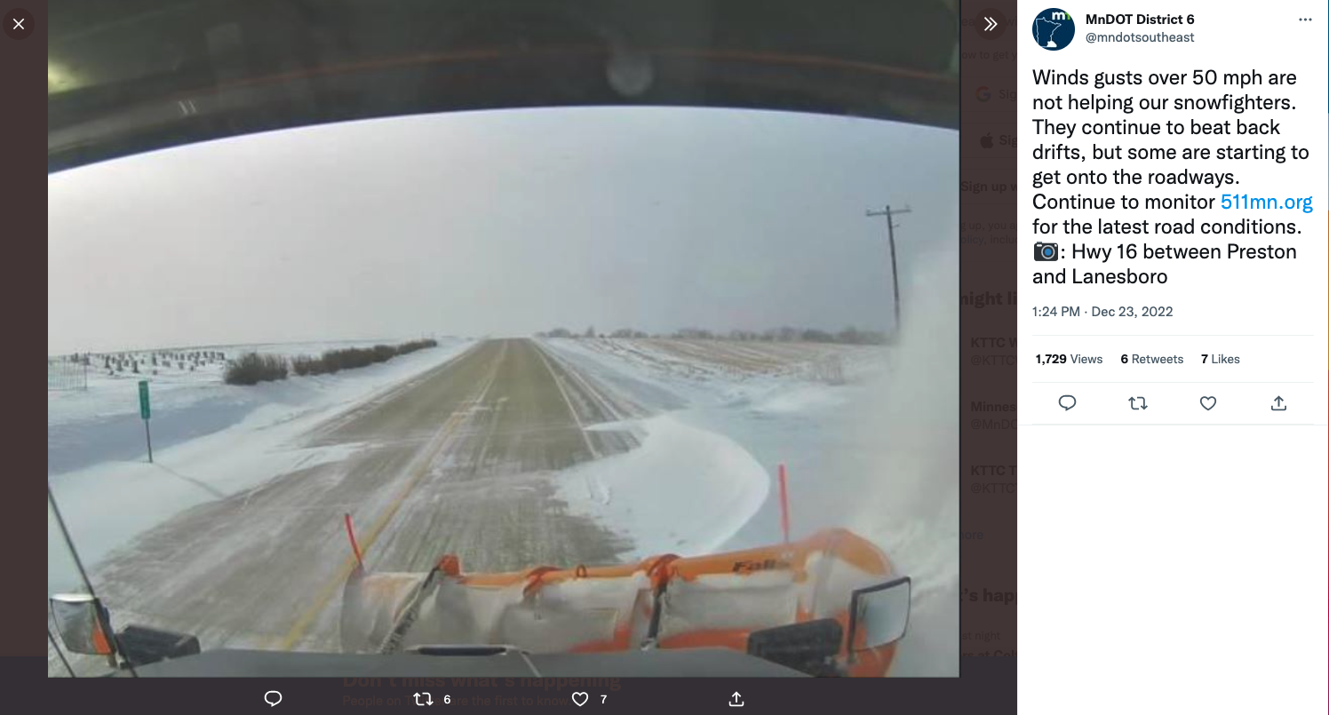
| MN DOT Plowcam Fri Evening Dec 23 |
MN DOT Plowcam Fri Evening Dec 23 |
IA DOT Plowcam Fri Afternoon Dec 23 |
IA DOT Plowcam Fri Afternoon Dec 23 |
 |
 |
.jfif) |
 |
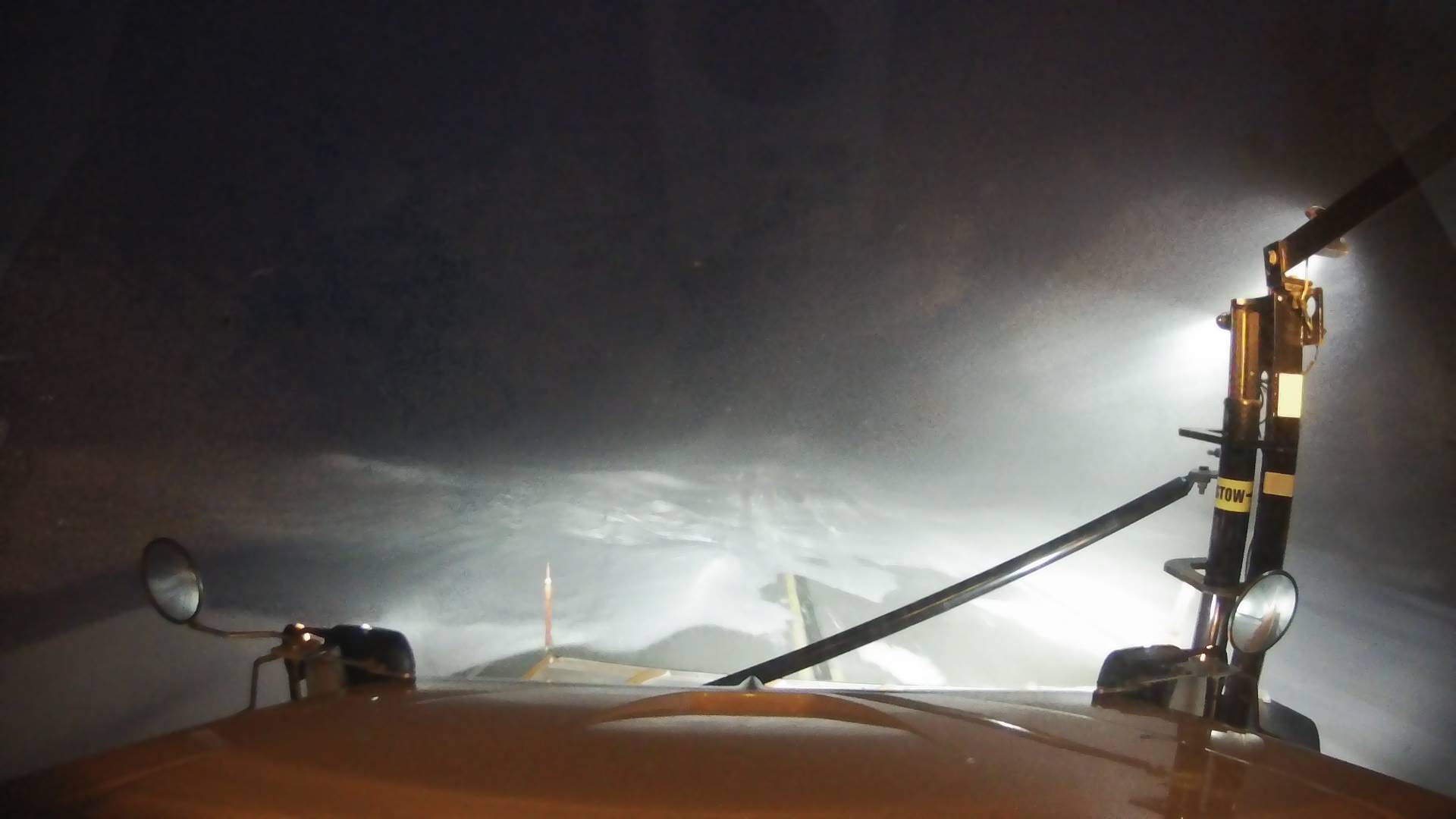
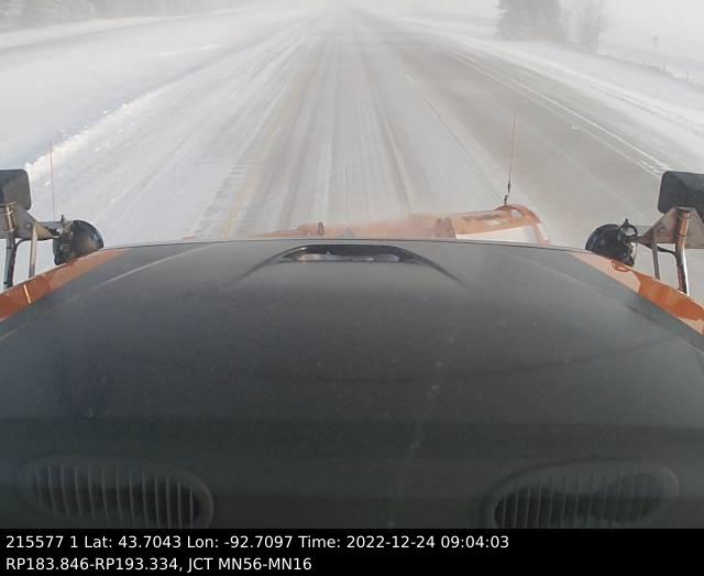
| MN DOT Plowcam Fri Afternoon Dec 23 |
MN DOT Plowcam Fri Afternoon Dec 23 |
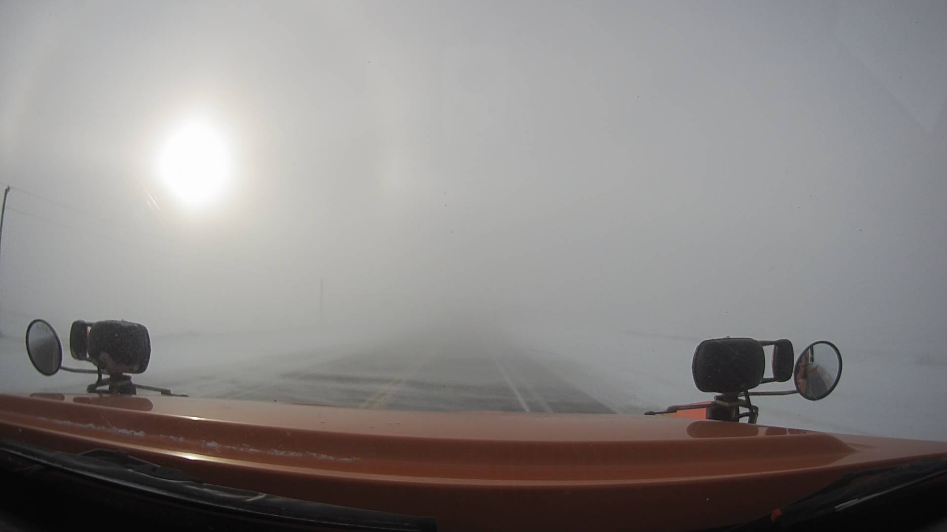
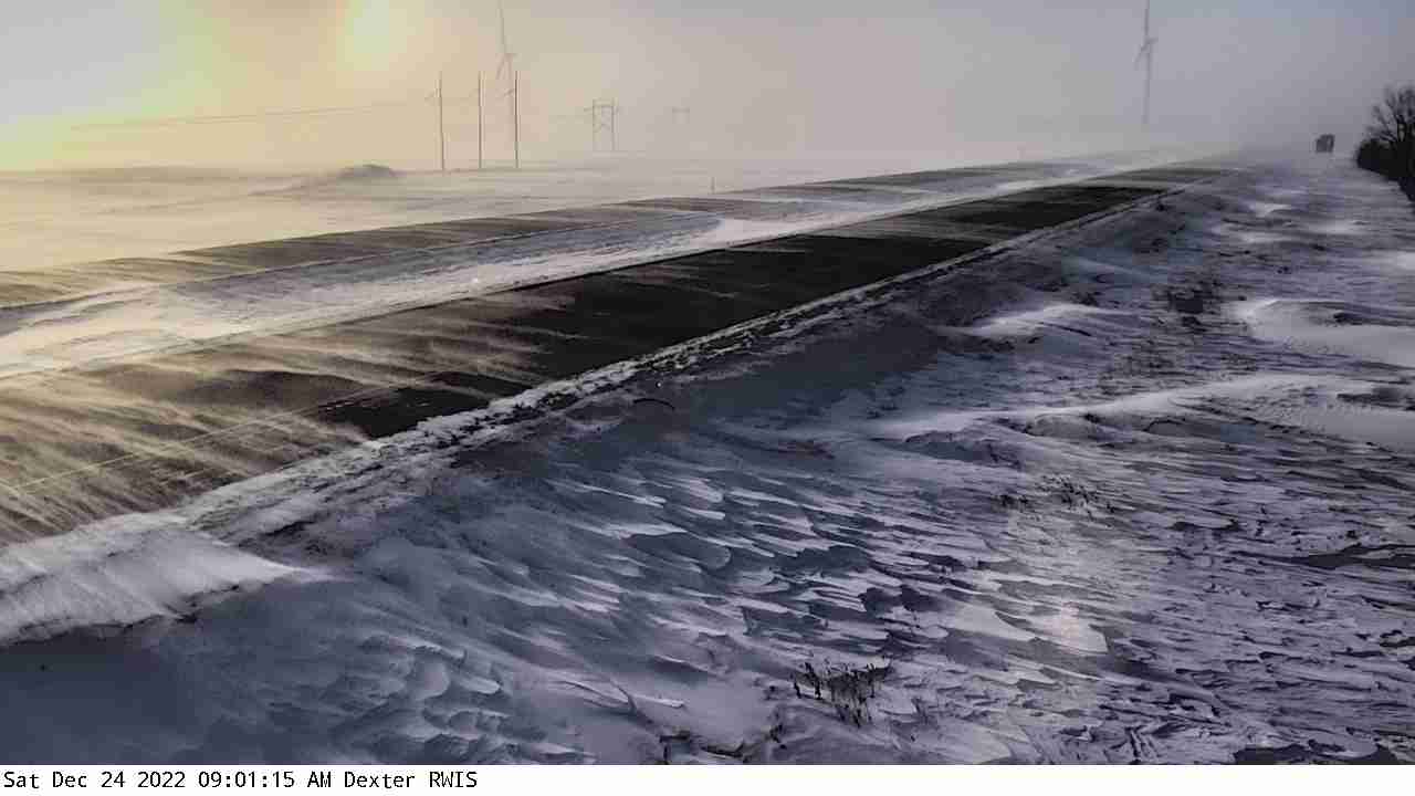
MN DOT RWIS Camera near Dexter, MN Sat morning Dec 24 |
MN DOT RWIS Camera near Dexter, MN Sat morning Dec 24 |
 |
 |
 |
 |
| MN DOT RWIS Camera near Dexter, MN Sat morning Dec 24 |
MN DOT Plowcam Fri Afternoon Dec 23 |
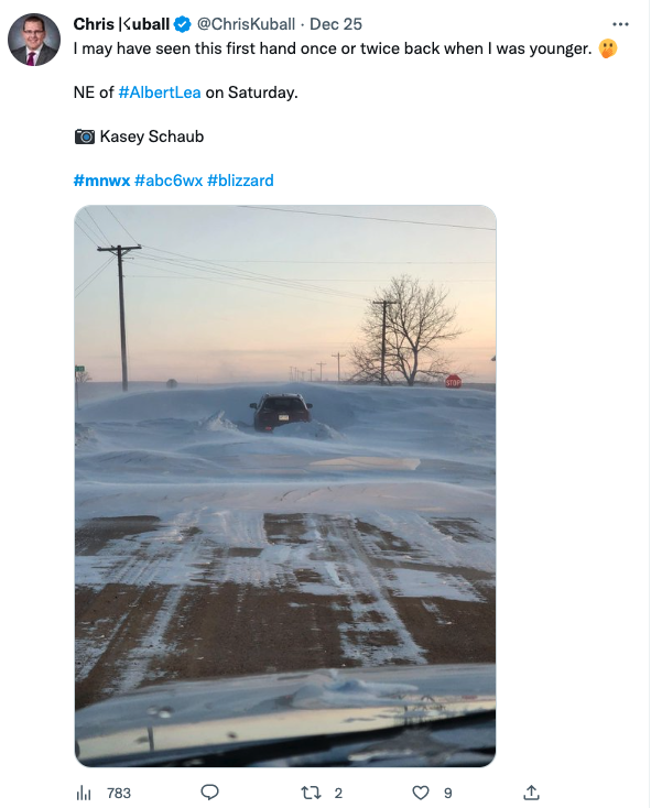
Image on Saturday Source: @ChrisKuball |
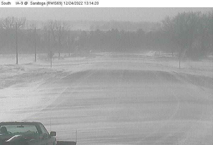
IA DOT RWIS Camera near Saratoga, IA Sat morning Dec 24 |
 |
|||
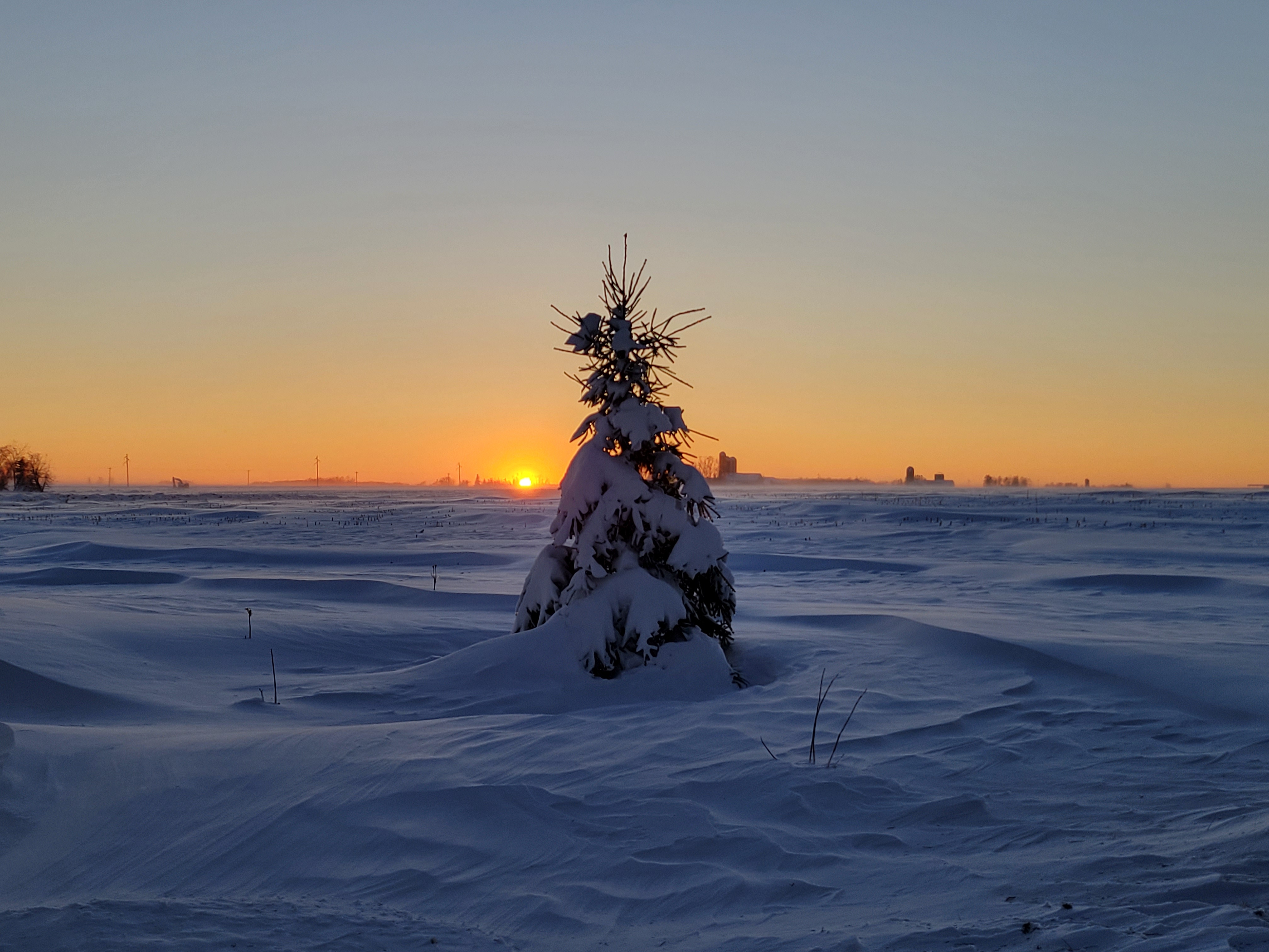
| Near Dorchester, WI (Tony Schumacher) |
Radar and Imagery:
|
 |
||
| Radar Loop of December 21 (3 pm) through 22nd (2 pm) | Snapshot loop of Mean Sea Level Pressure from Dec 21-25 2022 showing the deep low pressure developing in the Great Lakes |
Forecast
 |
 |
 |
| Local view of the forecasts as of Thu Dec 22 at 230 pm |
U.S View of the Forecasts as of Thu Dec 22 at 230 pm |
President Biden briefed by the NWS Director Ken Graham |
 |
 |
 |
| Forecast Graphic from Dec 21 2022 at 754 am |
Forecast Graphic from Dec 21 2022 at 752 am |
Forecast Graphic from Dec 21 2022 at 7 am |
 |
Media use of NWS Web News Stories is encouraged! Please acknowledge the NWS as the source of any news information accessed from this site. |
|


 Weather Story
 Weather Map
 Local Radar