
Strong to severe storms are expected to develop from mid afternoon through early evening. Damaging winds will be the main threat, but large hail and tornadoes are also possible. Have multiple ways to receive warnings and stay weather aware if you have outdoor plans. Read More >
Overview
|
A slow moving storm system brought a mix of rain, freezing rain, sleet, and finally snow to the area beginning Monday January 2 and lasting into Thursday January 5. The most impact occurred Monday night into Tuesday morning when freezing rain brought ice accumulations up to around 1/4 of an inch across southeast Minnesota into western Wisconsin. Temperatures warmed over most of the area for a change over to rain Tuesday, followed by colder air moving in Wednesday and Thursday with light snow accumulations up to about 3 inches. |
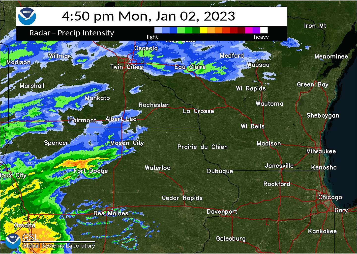 Initial period of the storm when a wintry mix and icing occurred Monday night and Tuesday Morning Jan 3 2023. |
Ice
PRELIMINARY LOCAL STORM REPORT...SUMMARY
NATIONAL WEATHER SERVICE LA CROSSE WI
349 PM CST SAT JAN 7 2023

..TIME...   ...EVENT...      ...CITY LOCATION...     ...LAT.LON...
..DATE...   ....MAG....      ..COUNTY LOCATION..ST.. ...SOURCE....
            ..REMARKS..

0857 AM     FREEZING RAIN    3 WNW STEVENSTOWN       44.06N 91.22W
01/03/2023  M0.30 INCH       TREMPEALEAU        WI   TRAINED SPOTTER

            WINTRY MIX OF SLEET, SNOW, AND FREEZING
            RAIN.

0857 AM     FREEZING RAIN    3 WNW STEVENSTOWN       44.06N 91.22W
01/03/2023  M0.30 INCH       TREMPEALEAU        WI   TRAINED SPOTTER

            WINTRY MIX OF SLEET, SNOW, AND FREEZING
            RAIN.

0812 AM     FREEZING RAIN    2 E LA CROSSE           43.82N 91.19W
01/03/2023  M0.08 INCH       LA CROSSE          WI   OFFICIAL NWS OBS


0900 AM     FREEZING RAIN    2 NNW WILSON            43.99N 91.71W
01/03/2023  M0.25 INCH       WINONA             MN   TRAINED SPOTTER

            WINTRY MIX OF ICE AND SLEET ON DRIVE. LESS
            ON TREES. RAINING NOW.

0900 AM     FREEZING RAIN    2 SSE DAKOTA            43.88N 91.34W
01/03/2023  M0.20 INCH       WINONA             MN   NWS EMPLOYEE

            ASYMMETRICAL ICE ACCUMULATION ON DOWEL,
            GREATER IN THE VERTICAL.

0900 AM     FREEZING RAIN    2 NNW WILSON            43.99N 91.71W
01/03/2023  M0.25 INCH       WINONA             MN   TRAINED SPOTTER

            WINTRY MIX OF ICE AND SLEET ON DRIVE. LESS
            ON TREES. RAINING NOW.

1200 PM     FREEZING RAIN    LEWISTON                43.98N 91.87W
01/03/2023  E0.20 INCH       WINONA             MN   PUBLIC

            PUBLIC REPORT VIA KAAL TV.

0832 AM     FREEZING RAIN    BYRON                   44.03N 92.64W
01/03/2023  M0.25 INCH       OLMSTED            MN   BROADCAST MEDIA


0945 AM     FREEZING RAIN    2 NNE ROCHESTER         44.04N 92.46W
01/03/2023  M0.19 INCH       OLMSTED            MN   TRAINED SPOTTER

            SEVEN MEASUREMENTS - SOME SLEET AND SNOW
            MIXED IN.

1200 PM     FREEZING RAIN    3 NNW ROCHESTER         44.05N 92.51W
01/03/2023  E0.25 INCH       OLMSTED            MN   PUBLIC

            PUBLIC REPORT VIA KAAL TV.

1204 PM     FREEZING RAIN    1 SSW ORONOCO           44.15N 92.54W
01/03/2023  E0.15 INCH       OLMSTED            MN   PUBLIC


0828 AM     FREEZING RAIN    3 WSW LA CRESCENT       43.81N 91.37W
01/03/2023  M0.05 INCH       HOUSTON            MN   BROADCAST MEDIA
Snow
...SNOWFALL TOTALS...

Location                     Amount    Time/Date       Lat/Lon

...Iowa...

...Allamakee County...
Postville 5.5 NE             1.5 in    0700 AM 01/05   43.14N/91.49W
Harpers Ferry 6.4 SSW        1.1 in    0700 AM 01/05   43.11N/91.20W

...Chickasaw County...
New Hampton 0.4 SW           0.7 in    0700 AM 01/05   43.06N/92.32W
Fredericksburg 0.3 S         0.5 in    0800 AM 01/05   42.96N/92.20W

...Clayton County...
Strawberry Point             1.2 in    0700 AM 01/05   42.69N/91.53W
McGregor 6.4 WNW             1.0 in    0716 AM 01/05   43.07N/91.29W
Elkader 6SSW                 0.7 in    0700 AM 01/05   42.78N/91.45W
Elkader 6.8 WSW              0.6 in    0600 AM 01/05   42.81N/91.52W

...Fayette County...
Oelwein 1 E                  0.8 in    0630 AM 01/05   42.68N/91.88W
Fayette                      0.8 in    0700 AM 01/05   42.88N/91.83W

...Floyd County...
Nora Springs 2.4 SSE         1.0 in    0700 AM 01/05   43.11N/92.99W

...Mitchell County...
Osage                        0.4 in    0800 AM 01/05   43.28N/92.81W
St Ansgar                    0.3 in    0630 AM 01/05   43.38N/92.92W
Osage                        0.2 in    0745 AM 01/04   43.28N/92.81W

...Winneshiek County...
7 ENE Decorah                1.0 in    0834 AM 01/05   43.34N/91.64W

...Minnesota...

...Dodge County...
Mantorville 1.9 ESE          2.4 in    0700 AM 01/04   44.05N/92.72W
Hayfield 0.3 SSE             1.2 in    0400 AM 01/04   43.89N/92.85W
Mantorville 1.9 ESE          1.0 in    0700 AM 01/05   44.05N/92.72W
Hayfield 0.3 SSE             0.9 in    0400 AM 01/05   43.89N/92.85W

...Fillmore County...
Wykoff 3.1 NW                1.8 in    0700 AM 01/05   43.74N/92.31W
Chatfield 9.0 ESE            1.2 in    0700 AM 01/05   43.79N/92.03W
Mabel                        1.0 in    0640 AM 01/05   43.52N/91.76W
Wykoff 3.1 NW                0.2 in    0700 AM 01/04   43.74N/92.31W

...Houston County...
1 ENE Mound Prairie          1.6 in    0700 AM 01/05   43.79N/91.42W
Hokah 4 NW                   1.6 in    0700 AM 01/05   43.80N/91.43W
3 WSW La Crescent            1.2 in    0441 AM 01/05   43.81N/91.37W
Caledonia                    1.0 in    0800 AM 01/05   43.63N/91.50W

...Mower County...
Grand Meadow                 1.0 in    0530 AM 01/05   43.71N/92.56W
Waltham 2.0 SE               1.0 in    0800 AM 01/05   43.80N/92.85W
Austin 2.4 W                 0.5 in    0710 AM 01/05   43.67N/93.02W
Austin 2.4 W                 0.3 in    0700 AM 01/04   43.67N/93.02W
Austin Waste Water Treatment 0.2 in    0700 AM 01/04   43.65N/92.97W

...Olmsted County...
Elgin 2SSW                   3.0 in    0700 AM 01/05   44.10N/92.27W
Oronoco 3.3 ESE              2.6 in    0700 AM 01/04   44.14N/92.48W
1 SSW Oronoco                2.5 in    1135 AM 01/04   44.15N/92.54W
Rochester 5.7 N              2.3 in    0740 AM 01/05   44.10N/92.46W
2 NE Rochester               2.0 in    0600 AM 01/04   44.04N/92.44W
Stewartville 4.3 E           2.0 in    0430 AM 01/05   43.86N/92.40W
2 NE Rochester               2.0 in    0600 AM 01/05   44.04N/92.44W
Rochester 5.7 N              1.5 in    0700 AM 01/04   44.10N/92.46W
Rochester 4.7 N              1.5 in    0700 AM 01/04   44.08N/92.48W
2 NNW Rochester              1.5 in    0800 AM 01/04   44.05N/92.49W
Oronoco 3.3 ESE              1.5 in    0700 AM 01/05   44.14N/92.48W
Rochester 4.7 N              1.3 in    0700 AM 01/05   44.08N/92.48W
2 NNE Rochester              1.2 in    0726 AM 01/04   44.04N/92.46W
Rochester 1.5 WSW            1.0 in    0600 AM 01/05   44.00N/92.50W
2 NNW Rochester              1.0 in    0600 AM 01/05   44.05N/92.49W
Rochester AP 2NE             0.9 in    0700 AM 01/04   43.93N/92.48W
Elba 4.7 SW                  0.9 in    1030 PM 01/04   44.04N/92.09W
Rochester AP 2NE             0.9 in    0700 AM 01/05   43.93N/92.48W
Elba 4.7 SW                  0.8 in    1159 PM 01/03   44.04N/92.09W
Stewartville 4.3 E           0.5 in    0430 AM 01/04   43.86N/92.40W
Rochester 4.2 N              0.5 in    0600 AM 01/05   44.08N/92.49W
Elgin 2SSW                   0.2 in    0700 AM 01/04   44.10N/92.27W

...Wabasha County...
Wabasha 6.2 WNW              3.4 in    0700 AM 01/04   44.39N/92.16W
Zumbro Falls 3.5 SSW         2.6 in    0735 AM 01/04   44.24N/92.46W
Theilman 1 SSW               2.4 in    0730 AM 01/04   44.28N/92.19W
Zumbro Falls 3.5 SSW         2.1 in    0846 AM 01/05   44.24N/92.46W
Wabasha 6.2 WNW              1.2 in    0700 AM 01/05   44.39N/92.16W

...Winona County...
2 NNW Wilson                 2.5 in    0835 AM 01/05   43.98N/91.71W
La Crescent 4.0 NNW          2.0 in    0700 AM 01/05   43.88N/91.34W
4.2 N Rollingstone           1.0 in    0800 AM 01/04   44.16N/91.81W
La Crescent 4.0 NNW          0.1 in    0700 AM 01/04   43.88N/91.34W

...Wisconsin...

...Adams County...
Arkdale                      2.0 in    0645 AM 01/05   44.03N/89.88W
9 ENE Friendship             2.0 in    0808 AM 01/05   44.01N/89.66W
0.6 W Friendship             1.4 in    0700 AM 01/05   43.98N/89.83W
Oxford 4.0 W                 1.3 in    0700 AM 01/05   43.79N/89.64W

...Buffalo County...
Mondovi 12.1 SSE             0.3 in    0645 AM 01/05   44.40N/91.60W

...Clark County...
Owen 1E                      0.5 in    0700 AM 01/04   44.95N/90.55W

...Crawford County...
Eastman                      1.2 in    0303 PM 01/05   43.17N/91.02W
Gays Mills 1.0 NE            1.0 in    0700 AM 01/05   43.33N/90.84W
Steuben 4SE                  0.9 in    0729 AM 01/05   43.13N/90.84W
0.6 NE Prairie Du Chien      0.8 in    0700 AM 01/05   43.05N/91.13W
Prairie Du Chien 1.4 N       0.7 in    0700 AM 01/05   43.06N/91.14W
1 S De Soto                  0.5 in    0626 AM 01/05   43.41N/91.19W

...Grant County...
4.3 W Lancaster              0.7 in    0800 AM 01/05   42.83N/90.79W
Cassville 7.8 ENE            0.3 in    0700 AM 01/05   42.75N/90.84W
4.3 W Lancaster              0.1 in    0800 AM 01/04   42.83N/90.79W

...Jackson County...
Melrose 3.6 W                2.9 in    0700 AM 01/05   44.13N/91.07W
Melrose 3.6 W                0.4 in    0700 AM 01/04   44.13N/91.07W

...Juneau County...
1.0 E Mauston                1.2 in    0800 AM 01/05   43.79N/90.06W

...La Crosse County...
La Crosse 4NNW               1.8 in    0730 AM 01/05   43.87N/91.27W
Onalaska 1.9 E               1.6 in    0700 AM 01/05   43.89N/91.18W
1 NNW Onalaska               1.5 in    0715 AM 01/05   43.90N/91.23W
2 E La Crosse                1.5 in    1025 AM 01/05   43.82N/91.19W
French Island                1.4 in    0600 AM 01/05   43.86N/91.27W
Coon Valley 4.5 NNW          1.3 in    0700 AM 01/05   43.76N/91.06W
West Salem 0.7 W             0.1 in    0700 AM 01/04   43.90N/91.10W
West Salem                   0.1 in    0700 AM 01/04   43.90N/91.09W
La Crosse 4NNW               0.1 in    0730 AM 01/04   43.87N/91.27W

...Monroe County...
Warrens 4.7 WSW              2.0 in    0700 AM 01/05   44.10N/90.59W
1 NNW Tomah                  1.5 in    0925 AM 01/05   44.01N/90.51W
Cashton 3 NNW                1.4 in    0733 AM 01/05   43.79N/90.80W
0.5 SW Sparta                1.0 in    0800 AM 01/05   43.94N/90.82W

...Richland County...
Richland Center 4 N          2.0 in    0700 AM 01/05   43.40N/90.39W

...Taylor County...
Medford 0.8 ENE              0.6 in    0700 AM 01/04   45.14N/90.33W
Medford 0.8 ENE              0.4 in    0700 AM 01/05   45.14N/90.33W

...Trempealeau County...
Ettrick 4.0 WNW              3.1 in    0838 AM 01/05   44.19N/91.34W
4 NW Stevenstown             2.5 in    0730 AM 01/05   44.07N/91.23W
Ettrick 4.0 WNW              0.8 in    0752 AM 01/04   44.19N/91.34W

...Vernon County...
Viroqua 0.8 ESE              1.5 in    0700 AM 01/05   43.55N/90.87W
Stoddard 4.7 NNE             1.3 in    0700 AM 01/05   43.72N/91.17W
Hillsboro 2 SW               1.2 in    0700 AM 01/05   43.63N/90.38W
Stoddard 1.5 NE              0.8 in    0730 AM 01/05   43.67N/91.19W

Observations are collected from a variety of sources with varying
equipment and exposures. We thank all volunteer weather observers
for their dedication. Not all data listed are considered official.

$$
Photos:
 |
 |
 |
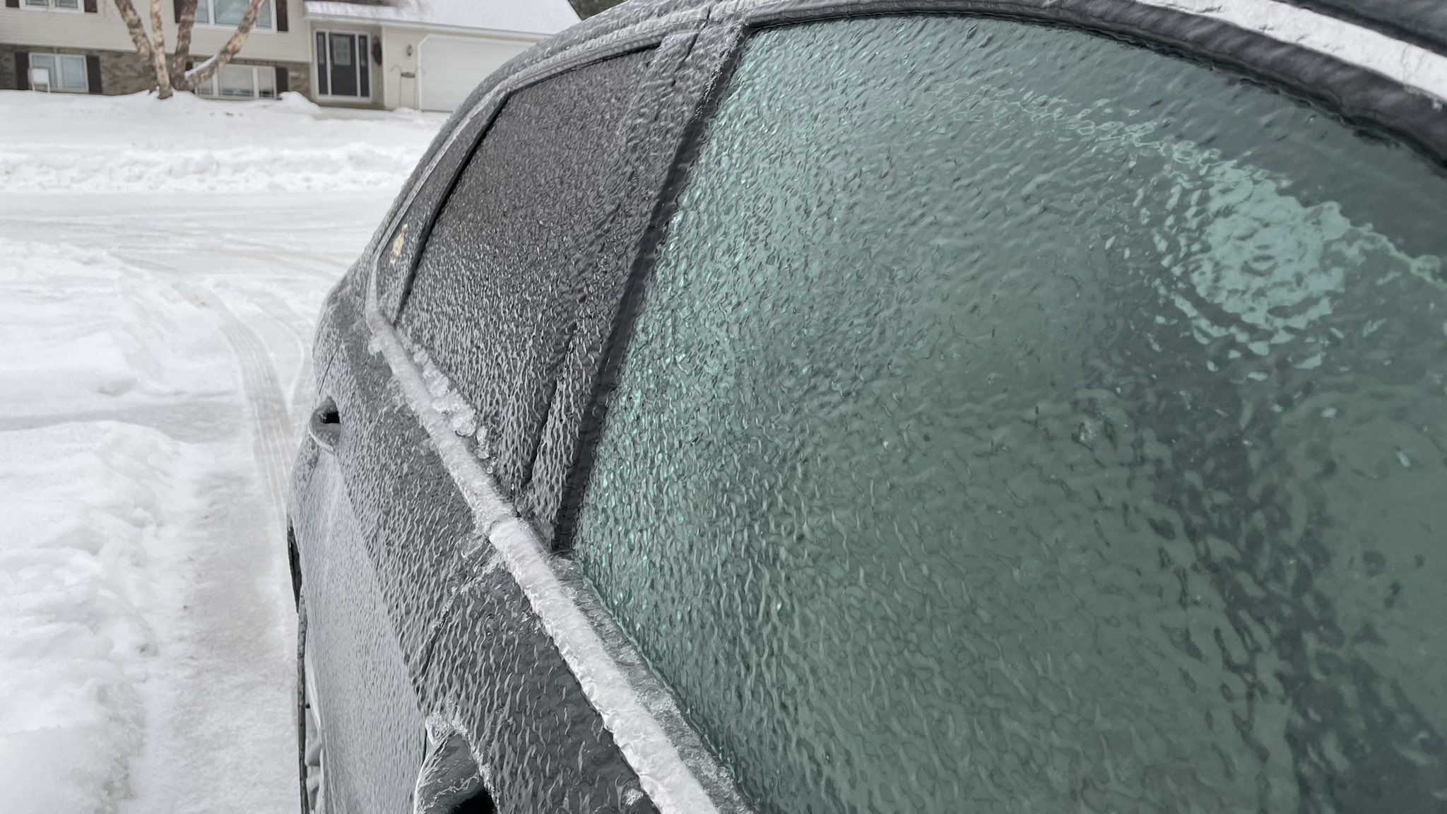 |
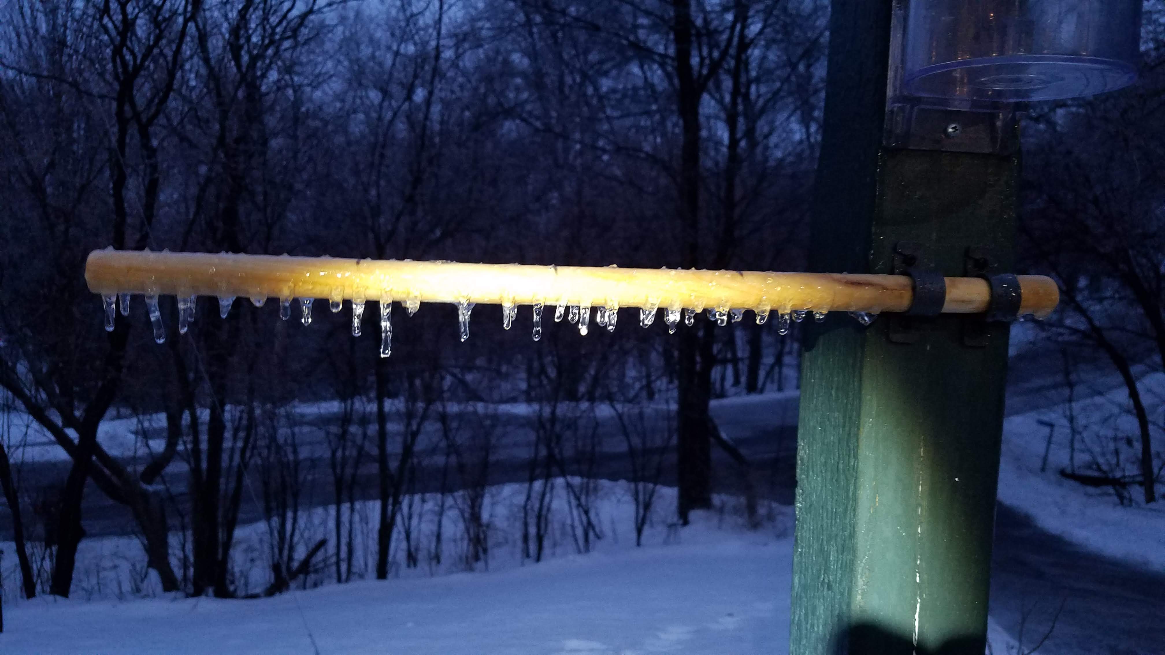
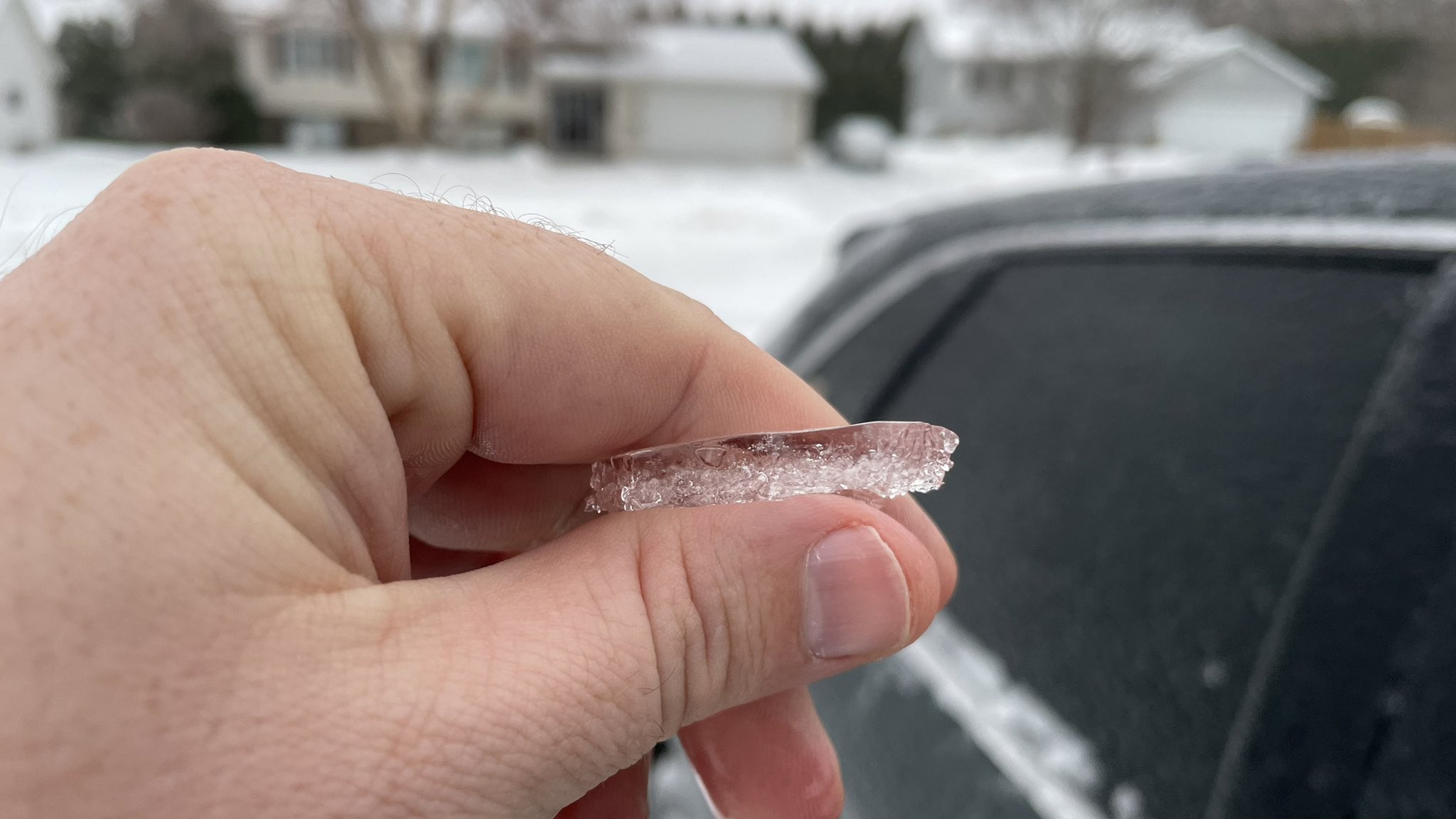
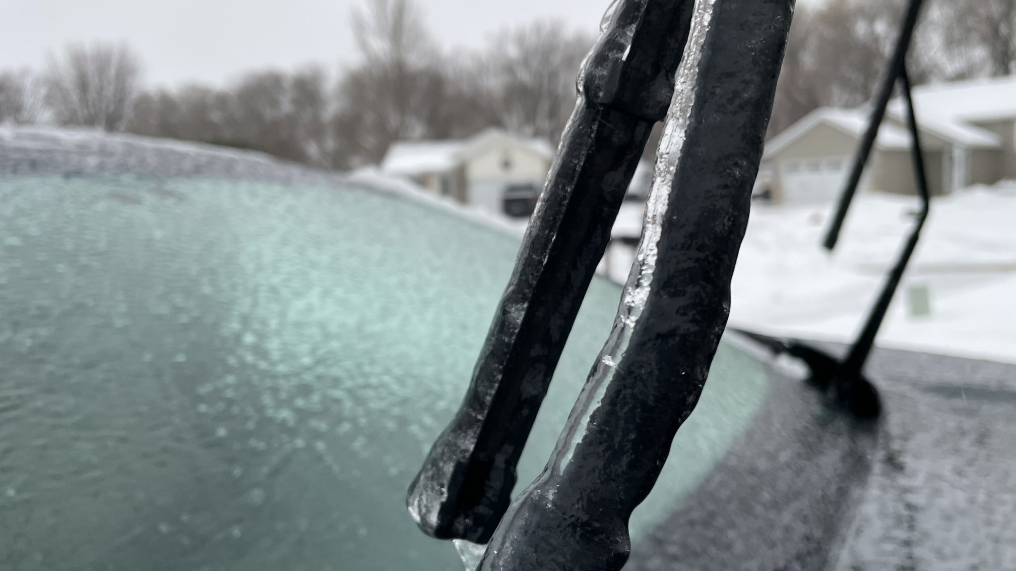
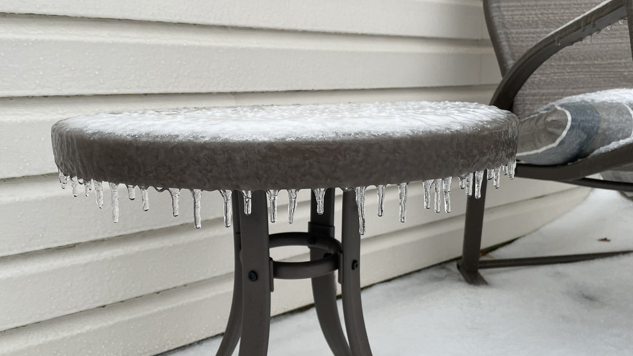
| Dakota, MN ice accumulation 7 am Tue Jan 3 2023 ​(NWS Andrea Skow) |
Dakota, MN ice accumulation 7 am Tue Jan 3 2023 ​(NWS Andrea Skow) |
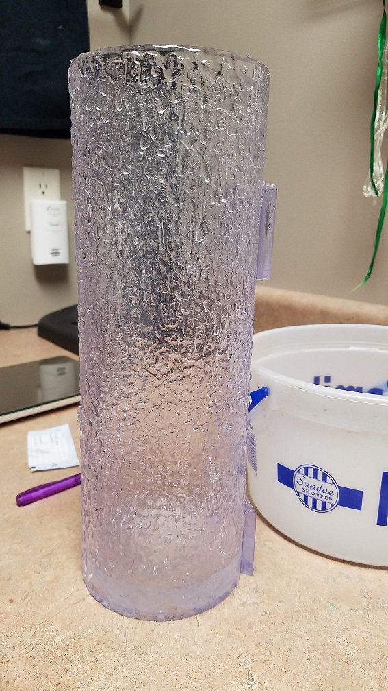
NWS La Crosse ice accumulation 915 am Tue Jan 3 2023 |
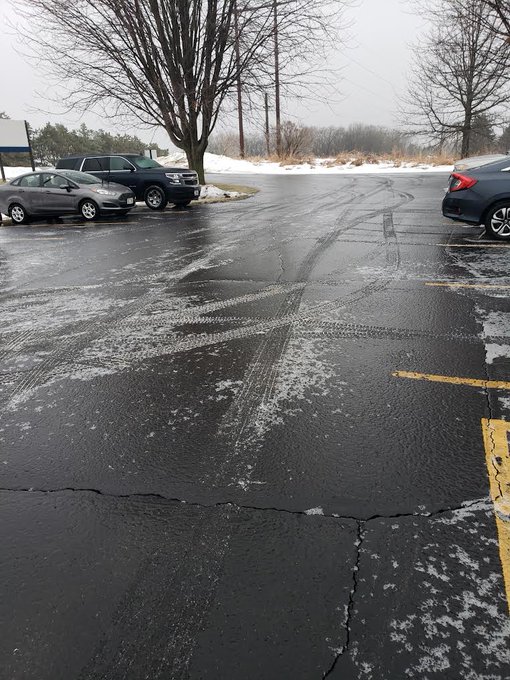
Rochester, MN ice accumulation 8 am Tue Jan 3 2023 (Twitter @ChrisKuball ABC 6 News) |
 |
 |
 |
|
| Rochester, MN ice Accumulation 8 am Tue Jan 3 2023 ​(Twitter @ChrisKuball ABC 6 News) |
Rochester, MN Ice Accumulation 8 am Tue Jan 3 2023 ​(Twitter @ChrisKuball ABC 6 News) |
Rochester, MN Ice Accumulation 8 am Tue Jan 3 2023 ​(Twitter @ChrisKuball ABC 6 News) |
 |
Media use of NWS Web News Stories is encouraged! Please acknowledge the NWS as the source of any news information accessed from this site. |
|


 Weather Story
 Weather Map
 Local Radar