Overview
|
Two rounds of strong to severe storms impacted the area on Wednesday, July 14th 2021. The first round was a line of strong thunderstorms that produced upwards of 40 to 50 mph winds and pockets of heavy rainfall. Severe weather was limited with this line. The line impacted most of the area. The second round sparked by mid to late afternoon, continuing into mid evening, highlighted by supercell storms producing tornadoes. Most of this activity was confined to portions of Iowa. Elsewhere, very heavy rain resulted in localized, mostly urban flooding. |
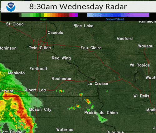
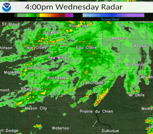 Radar loop 4 to 9 pm, July 14th 2021 |
Tornadoes:
|
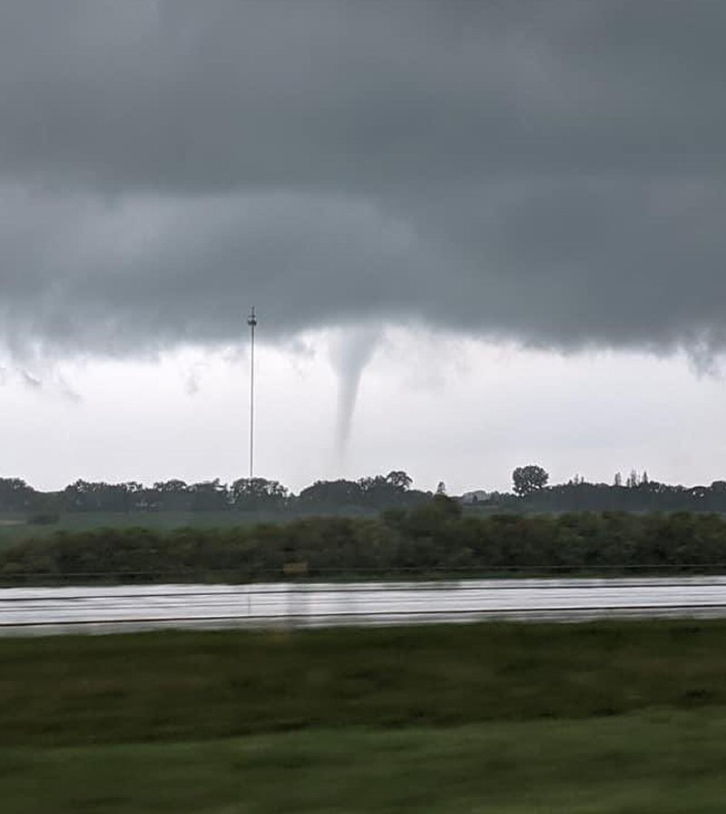
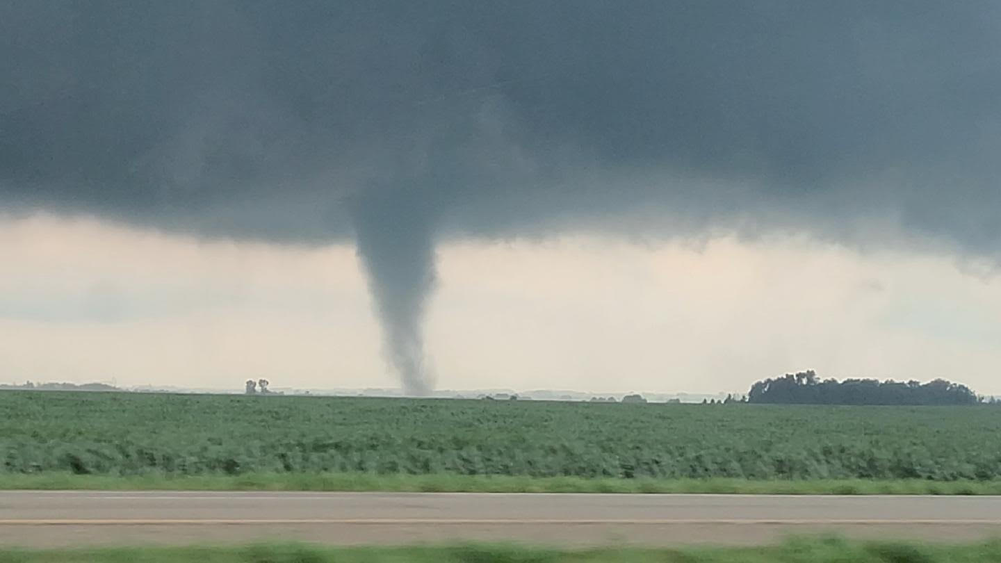
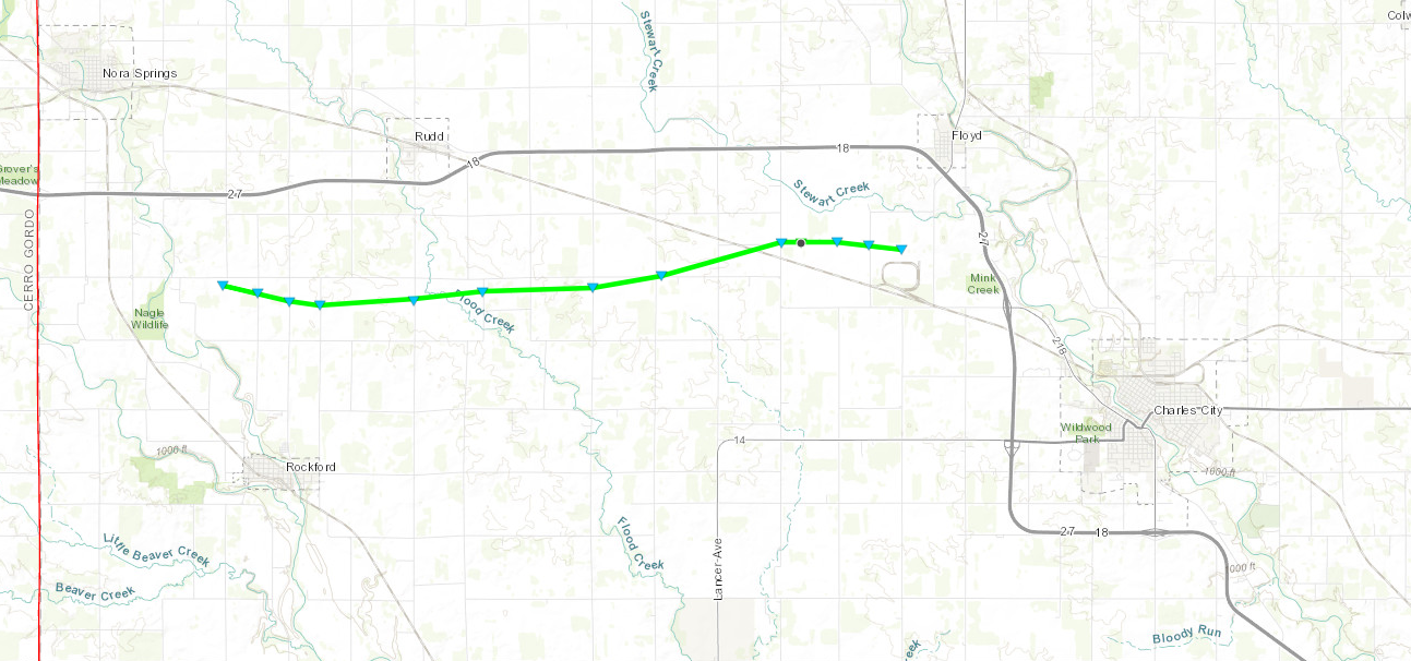
Tornado - ROCKFORD-RUDD, IOWA
|
||||||||||||||||
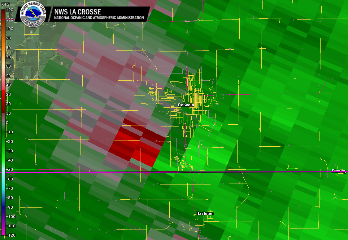
|
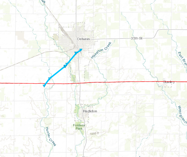
Tornado - OELWEIN, IOWA
|
||||||||||||||||
The Enhanced Fujita (EF) Scale classifies tornadoes into the following categories:
| EF0 Weak 65-85 mph |
EF1 Moderate 86-110 mph |
EF2 Significant 111-135 mph |
EF3 Severe 136-165 mph |
EF4 Extreme 166-200 mph |
EF5 Catastrophic 200+ mph |
 |
|||||
Wind
PUBLIC INFORMATION STATEMENT
NATIONAL WEATHER SERVICE LA CROSSE WI
808 AM CDT THU JUL 15 2021

...HIGHEST WIND REPORTS PAST 24 HOURS...

LOCATION                     SPEED     TIME/DATE       LAT/LON

...IOWA...

...CHICKASAW COUNTY...
2 N IONIA                    30 MPH    1000 AM 07/14   43.07N/92.46W

...FAYETTE COUNTY...
OELWEIN MUNICIPAL AIRPORT    37 MPH    1035 AM 07/14   42.68N/91.97W

...FLOYD COUNTY...
CHARLES CITY AIRPORT         44 MPH    0955 AM 07/14   43.07N/92.62W

...WINNESHIEK COUNTY...
5 NW FRANKVILLE              28 MPH    1100 AM 07/14   43.25N/91.70W
DECORAH MUNICIPAL AIRPORT    26 MPH    1055 AM 07/14   43.27N/91.72W

...MINNESOTA...

...OLMSTED COUNTY...
ROCHESTER INTERNATIONAL AIRP 36 MPH    1012 AM 07/14   43.90N/92.50W
3 N STEWARTVILLE             34 MPH    1020 AM 07/14   43.90N/92.48W
JCT CR 7 I-90 MILE POST 226  30 MPH    1035 AM 07/14   43.96N/92.21W

...WABASHA COUNTY...
WABASHA                      32 MPH    1118 AM 07/14   44.30N/92.00W
1 SSE KELLOGG                27 MPH    1105 AM 07/14   44.28N/91.99W

...WINONA COUNTY...
WINONA MUNICIPAL AIRPORT     29 MPH    1135 AM 07/14   44.07N/91.70W
1 E RIDGEWAY                 29 MPH    1135 AM 07/14   43.91N/91.54W

...WISCONSIN...

...CRAWFORD COUNTY...
PRAIRIE DU CHIEN  AIRPORT    25 MPH    0835 PM 07/14   43.02N/91.12W

...GRANT COUNTY...
LANCASTER                    37 MPH    1241 PM 07/14   42.83N/90.69W
BOSCOBEL AIRPORT             36 MPH    1210 PM 07/14   43.15N/90.68W
PLATTEVILLE                  35 MPH    0316 PM 07/14   42.74N/90.46W
PLATTEVILLE MUNICIPAL AIRPOR 33 MPH    1235 PM 07/14   42.68N/90.43W

...JUNEAU COUNTY...
MAUSTON AIRPORT              28 MPH    0115 PM 07/14   43.83N/90.13W
VOLK FIELD                   26 MPH    0114 PM 07/14   43.92N/90.27W

...LA CROSSE COUNTY...
LA CROSSE REGIONAL AIRPORT   30 MPH    1155 AM 07/14   43.88N/91.25W

...MONROE COUNTY...
SPARTA/FORT MCCOY AIRPORT    28 MPH    1235 PM 07/14   43.97N/90.73W

...TAYLOR COUNTY...
MEDFORD AIRPORT              35 MPH    0215 PM 07/14   45.10N/90.30W
WESTBORO                     32 MPH    0235 PM 07/14   45.37N/90.31W

...VERNON COUNTY...
VIROQUA MUNICIPAL AIRPORT    37 MPH    1215 PM 07/14   43.58N/90.90W

OBSERVATIONS ARE COLLECTED FROM A VARIETY OF SOURCES WITH VARYING
EQUIPMENT AND EXPOSURES. WE THANK ALL VOLUNTEER WEATHER OBSERVERS
FOR THEIR DEDICATION. NOT ALL DATA LISTED ARE CONSIDERED OFFICIAL.

$$
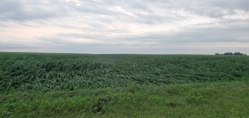
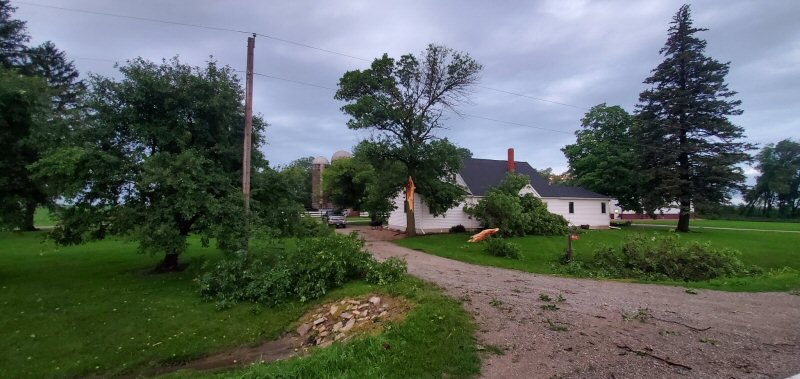
Photos:
 |
 |
 |
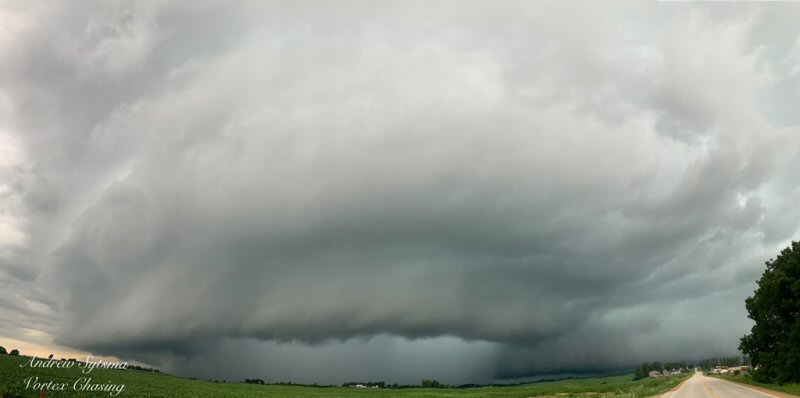 |
| Floyd County, IA (source: Aaron Jones) |
Rockford, IA (source: Shawn Cable) |
2 miles S of Rudd, IA (source: Shawn Cable) |
New Hampton, IA (source: Andrew Sytsma) |
 |
 |
 |
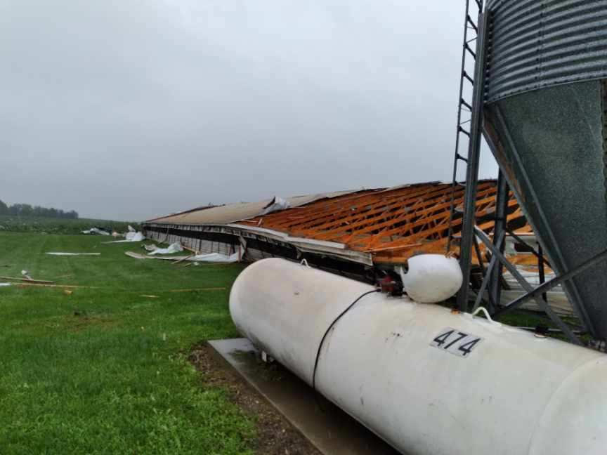 |
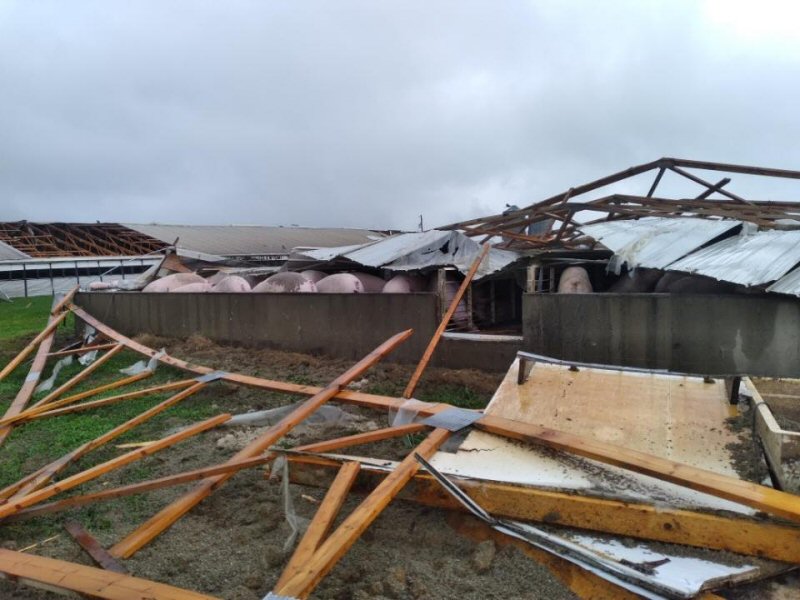
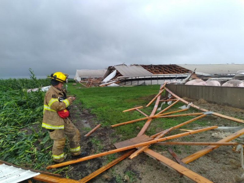
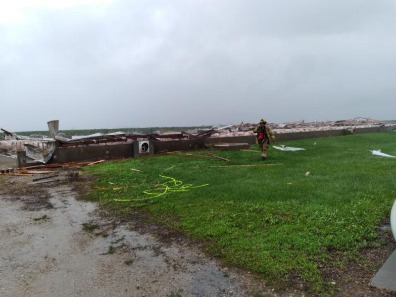
| Hog Farm 6m NW Charles City (source: City of Floyd F.D.) |
Hog Farm 6m NW Charles City (source: City of Floyd F.D) |
Hog Farm 6m NW Charles City (source: City of Floyd F.D) |
Hog Farm 6m NW Charles City (source: City of Floyd F.D) |
 |
|||
| Near Rudd (source: Jason Webster CCFD) |
Radar:
 |
|
 |
 |
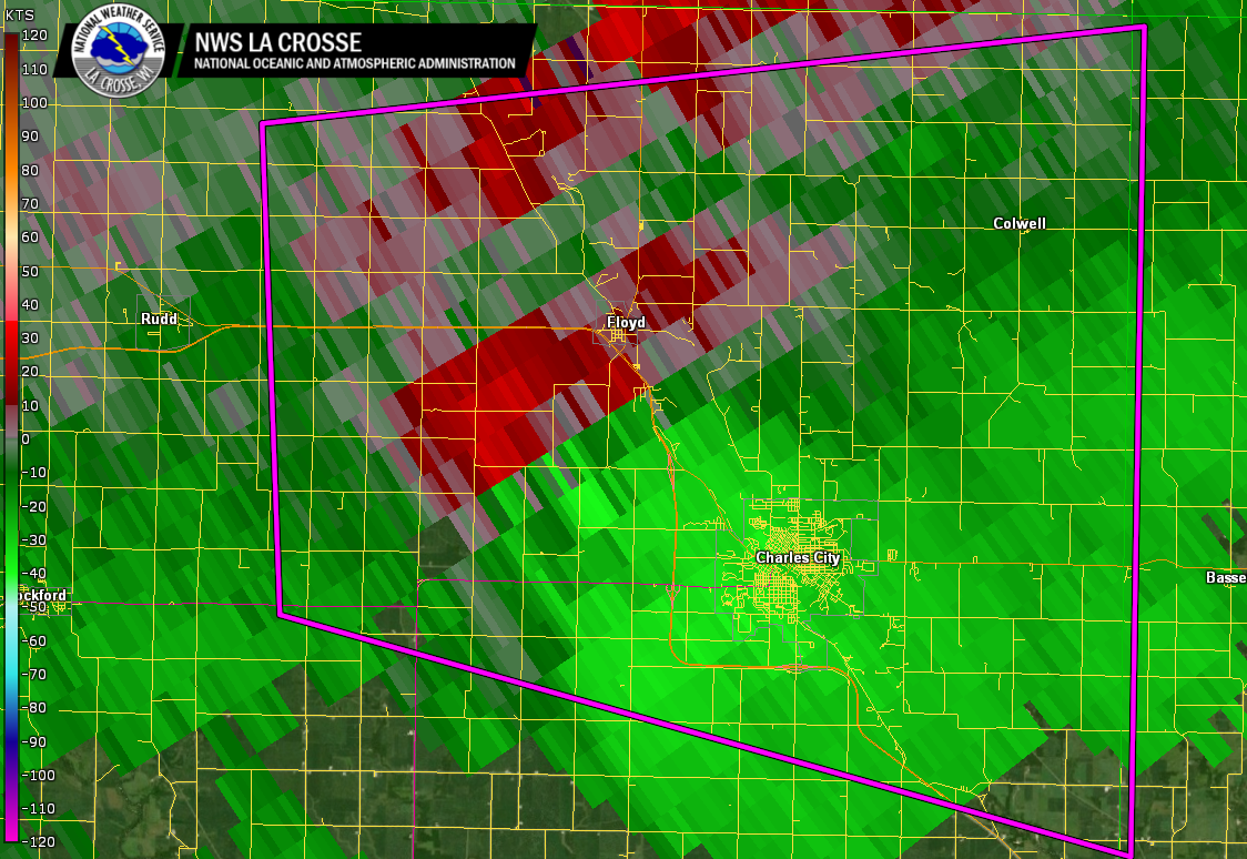
| 830 am to 1 pm radar loop | 4 to 9 pm radar loop | Tornadic circulation near Floyd, IA at end of tornado path | Tornadic circulation near Oelwein, IA |
Storm Reports
PRELIMINARY LOCAL STORM REPORT...SUMMARY
NATIONAL WEATHER SERVICE LA CROSSE WI
805 PM CDT WED JUL 14 2021

..TIME...   ...EVENT...      ...CITY LOCATION...     ...LAT.LON...
..DATE...   ....MAG....      ..COUNTY LOCATION..ST.. ...SOURCE....
            ..REMARKS..

0955 AM     TSTM WND GST     3 E CHARLES CITY        43.07N 92.62W
07/14/2021  M44 MPH          FLOYD              IA   AWOS

            AWOS STATION KCCY CHARLES CITY AIRPORT.

1035 AM     TSTM WND GST     3 W OELWEIN             42.68N 91.97W
07/14/2021  M37 MPH          FAYETTE            IA   AWOS

            AWOS STATION KOLZ OELWEIN MUNICIPAL AIRPORT.

1106 AM     TSTM WND GST     STRAWBERRY POINT        42.69N 91.54W
07/14/2021  E40 MPH          CLAYTON            IA   PUBLIC

            PEA-SIZED HAIL WITH TREES BENT FROM WIND
            GUSTS.

1123 AM     HEAVY RAIN       4 E ROCKFORD            43.05N 92.87W
07/14/2021  M1.30 INCH       FLOYD              IA   PUBLIC


1144 AM     HEAVY RAIN       COLWELL                 43.16N 92.59W
07/14/2021  M1.75 INCH       FLOYD              IA   TRAINED SPOTTER


1204 PM     TSTM WND GST     CASSVILLE               42.72N 90.99W
07/14/2021  U40 MPH          GRANT              WI   FIRE DEPT/RESCUE


1215 PM     TSTM WND GST     2 NNW VIROQUA           43.58N 90.90W
07/14/2021  M37 MPH          VERNON             WI   AWOS

            AWOS STATION KY51 VIROQUA MUNICIPAL AIRPORT.

1222 PM     TSTM WND GST     DICKEYVILLE             42.63N 90.59W
07/14/2021  E40 MPH          GRANT              WI   FIRE DEPT/RESCUE


1228 PM     TSTM WND GST     LIVINGSTON              42.90N 90.43W
07/14/2021  E55 MPH          GRANT              WI   FIRE DEPT/RESCUE


1241 PM     TSTM WND GST     2 SE LANCASTER          42.83N 90.69W
07/14/2021  M37 MPH          GRANT              WI   MESONET

            MESONET STATION LKRW3 LANCASTER.

1243 PM     TSTM WND GST     HAZEL GREEN             42.53N 90.44W
07/14/2021  E50 MPH          GRANT              WI   FIRE DEPT/RESCUE


1245 PM     TSTM WND GST     FORT MC COY             44.02N 90.68W
07/14/2021  E46 MPH          MONROE             WI   PUBLIC

            SMALL 3-4 INCH DIAMETER TREE UPROOTED.

0429 PM     HEAVY RAIN       EASTMAN                 43.17N 91.02W
07/14/2021  M0.72 INCH       CRAWFORD           WI   PUBLIC


0429 PM     HEAVY RAIN       SINSINAWA               42.52N 90.54W
07/14/2021  M0.62 INCH       GRANT              WI   TRAINED SPOTTER


0540 PM     TORNADO          2 S NORA SPRINGS        43.16N 93.01W
07/14/2021                   FLOYD              IA   TRAINED SPOTTER


0551 PM     TORNADO          1 ESE RUDD              43.12N 92.89W
07/14/2021                   FLOYD              IA   TRAINED SPOTTER


0556 PM     TORNADO          4 SW FLOYD              43.09N 92.80W
07/14/2021                   FLOYD              IA   FIRE DEPT/RESCUE


0603 PM     HAIL             1 W COLWELL             43.16N 92.61W
07/14/2021  M0.25 INCH       FLOYD              IA   TRAINED SPOTTER

            AND ALSO 40 MPH WIND GUSTS.

0608 PM     TSTM WND GST     FLOYD                   43.13N 92.74W
07/14/2021  E75 MPH          FLOYD              IA   FIRE DEPT/RESCUE

            REPORTED AT TRUCK STOP IN TOWN.

0623 PM     TSTM WND DMG     OELWEIN                 42.68N 91.91W
07/14/2021                   FAYETTE            IA   TRAINED SPOTTER

            REPORTS OF BUILDING DAMAGE AROUND TOWN.

0630 PM     HEAVY RAIN       2 NE MOUND PRAIRIE      43.80N 91.43W
07/14/2021  M2.48 INCH       HOUSTON            MN   CO-OP OBSERVER


0705 PM     HEAVY RAIN       1 S COLWELL             43.14N 92.59W
07/14/2021  E2.25 INCH       FLOYD              IA   TRAINED SPOTTER


0727 PM     HEAVY RAIN       FAYETTE                 42.84N 91.80W
07/14/2021  M1.65 INCH       FAYETTE            IA   AMATEUR RADIO


0758 PM     HEAVY RAIN       1 NNW ONALASKA          43.90N 91.23W
07/14/2021  M0.80 INCH       LA CROSSE          WI   PUBLIC
Rain Reports
Radar Rainfall Estimate
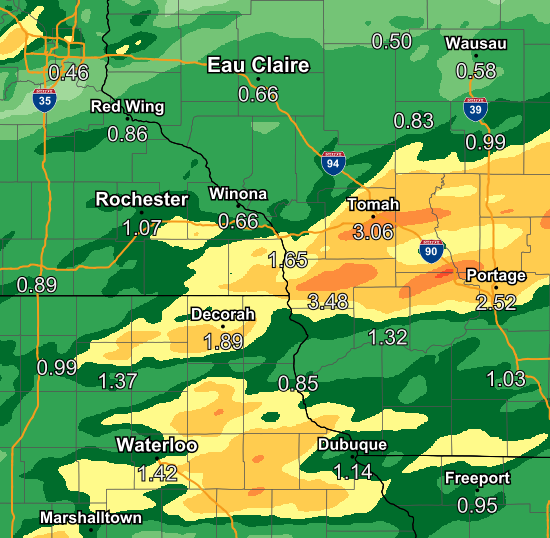
Public Information Statement
National Weather Service La Crosse WI
935 AM CDT Thu Jul 15 2021

...PRECIPITATION REPORTS LAST 24 HOURS...

Location                     Amount    Time/Date       Lat/Lon

...Iowa...

...Allamakee County...
3 S Dorchester               1.30 in   0900 AM 07/15   43.42N/91.51W
Waukon 0.8 S                 1.25 in   0650 AM 07/15   43.26N/91.47W
Lansing 4.1 NW               1.11 in   0700 AM 07/15   43.40N/91.29W
3 SE Waterville              1.08 in   0907 AM 07/15   43.17N/91.24W
Harpers Ferry 4.1 SW         0.85 in   0800 AM 07/15   43.16N/91.21W
Postville 5.5 NE             0.79 in   0700 AM 07/15   43.14N/91.49W
Harpers Ferry 6.4 SSW        0.75 in   0700 AM 07/15   43.11N/91.20W

...Chickasaw County...
New Hampton                  0.85 in   0700 AM 07/15   43.06N/92.32W
Ionia 2W                     0.83 in   0700 AM 07/15   43.03N/92.50W
New Hampton 0.4 SW           0.78 in   0700 AM 07/15   43.06N/92.32W

...Clayton County...
Strawberry Point             2.98 in   0700 AM 07/15   42.69N/91.53W
Elkader 6.8 WSW              2.41 in   0600 AM 07/15   42.81N/91.52W
Guttenberg Dam 10            1.90 in   0600 AM 07/15   42.79N/91.10W
Elkader 6SSW                 1.80 in   0700 AM 07/15   42.78N/91.45W
Garber                       1.77 in   0815 AM 07/15   42.74N/91.26W
Big Spring Fish Hatchery     1.43 in   0900 AM 07/15   42.91N/91.47W
1 WSW Marquette              0.51 in   0900 AM 07/15   43.04N/91.21W

...Fayette County...
Oelwein 0.3 E                2.52 in   0700 AM 07/15   42.68N/91.91W
Fayette                      1.65 in   0657 AM 07/15   42.88N/91.83W
Eldorado 1E - Turkey River   1.06 in   0700 AM 07/15   43.05N/91.81W
Waucoma 3.2 S                0.93 in   0700 AM 07/15   43.01N/92.03W
Eldorado 1E - Turkey River   0.92 in   0845 AM 07/15   43.05N/91.81W
Waucoma 1 WNW                0.50 in   0700 AM 07/15   43.06N/92.05W

...Floyd County...
Nora Springs 2.4 SSE         2.00 in   0700 AM 07/15   43.11N/92.99W
Charles City                 1.96 in   0700 AM 07/15   43.06N/92.67W
Nashua 2SW                   0.98 in   0600 AM 07/15   42.94N/92.57W

...Howard County...
Riceville                    1.56 in   0916 AM 07/15   43.36N/92.48W

...Mitchell County...
Osage 4.7 E                  1.77 in   0700 AM 07/15   43.28N/92.72W
Osage                        1.55 in   0700 AM 07/15   43.28N/92.81W
St Ansgar                    0.96 in   0630 AM 07/15   43.38N/92.92W

...Winneshiek County...
Decorah 4.9SE                2.59 in   0700 AM 07/15   43.26N/91.70W
Spillville                   2.49 in   0800 AM 07/15   43.21N/91.95W
Spillville                   2.31 in   0830 AM 07/15   43.21N/91.95W
7 ENE Decorah                1.96 in   0824 AM 07/15   43.34N/91.64W
Decorah                      1.66 in   0845 AM 07/15   43.30N/91.80W
Calmar                       1.62 in   0700 AM 07/15   43.19N/91.86W
1 ENE Bluffton               1.31 in   0845 AM 07/15   43.41N/91.90W
1 ENE Bluffton               1.28 in   0200 AM 07/15   43.41N/91.90W

...Minnesota...

...Dodge County...
Claremont 2.5 ESE            1.03 in   0800 AM 07/15   44.04N/92.95W
Mantorville 1.9 ESE          0.92 in   0700 AM 07/15   44.05N/92.72W
Hayfield                     0.84 in   0927 AM 07/15   43.89N/92.85W
Hayfield 0.3 SSE             0.79 in   0800 AM 07/15   43.89N/92.85W
Claremont 3.1 S              0.75 in   0700 AM 07/15   44.00N/92.99W
Hayfield 0.6 WNW             0.73 in   0700 AM 07/15   43.89N/92.86W

...Fillmore County...
Chatfield 9.0 ESE            1.53 in   0700 AM 07/15   43.79N/92.03W
Preston 3.2 NNE              1.43 in   0700 AM 07/15   43.71N/92.05W
Wykoff 3.1 NW                1.34 in   0700 AM 07/15   43.74N/92.31W
Mabel                        1.15 in   0630 AM 07/15   43.52N/91.76W
Spring Valley                0.89 in   0700 AM 07/15   43.69N/92.39W
1 NNW Fillmore               0.80 in   0830 AM 07/15   43.76N/92.27W
Lanesboro                    0.56 in   0830 AM 07/15   43.72N/91.98W

...Houston County...
1 ENE Mound Prairie          2.67 in   0700 AM 07/15   43.79N/91.42W
Mound Prairie                2.35 in   0600 AM 07/15   43.78N/91.45W
Mound Prairie                2.31 in   0845 AM 07/15   43.78N/91.45W
La Crescent 5.4 SW           2.27 in   0700 AM 07/15   43.78N/91.39W
Houston                      2.19 in   0929 AM 07/15   43.77N/91.58W
Houston 6.9 E                2.14 in   0845 AM 07/15   43.76N/91.43W
Caledonia 5.4 S              2.05 in   0800 AM 07/15   43.56N/91.51W
Caledonia                    1.93 in   0700 AM 07/15   43.63N/91.50W
La Crescent 1.0 WSW          1.87 in   0700 AM 07/15   43.83N/91.32W
La Crescent 0.7 N            1.79 in   0730 AM 07/15   43.84N/91.30W
Mabel 2.7 E                  1.34 in   0800 AM 07/15   43.51N/91.71W

...Mower County...
Ostrander 5.1 WNW            1.00 in   0700 AM 07/15   43.65N/92.52W
Austin 1.5 WSW               0.88 in   0700 AM 07/15   43.67N/93.00W
Austin 1.9 ENE               0.74 in   0800 AM 07/15   43.68N/92.94W
Austin 3 NW - Turtle Creek   0.53 in   0830 AM 07/15   43.65N/92.98W

...Olmsted County...
Elgin 2SSW                   1.43 in   0700 AM 07/15   44.10N/92.27W
Stewartville 4.3 E           1.36 in   0400 AM 07/15   43.86N/92.40W
Rochester                    1.27 in   0925 AM 07/15   44.04N/92.44W
Rochester 1.5 WSW            1.20 in   0700 AM 07/15   44.00N/92.50W
1 W Chester                  1.19 in   0612 AM 07/15   44.00N/92.38W
Byron 0.5 NNE                1.13 in   0800 AM 07/15   44.04N/92.64W
Rochester 5.8 ENE            1.00 in   0700 AM 07/15   44.06N/92.38W
Rochester 4.2 N              0.98 in   0600 AM 07/15   44.08N/92.49W
Rochester-Beltline Bear Cree 0.97 in   0830 AM 07/15   44.01N/92.45W
Rochester AP 2NE             0.96 in   0700 AM 07/15   43.93N/92.48W
Rochester 3.3 ENE            0.95 in   0800 AM 07/15   44.04N/92.42W
Rochester 4.7 N              0.93 in   0700 AM 07/15   44.08N/92.48W
2 NNW Rochester              0.93 in   0600 AM 07/15   44.05N/92.49W
Rochester International Airp 0.90 in   0925 AM 07/15   43.90N/92.50W
5 WSW Rochester              0.86 in   0900 AM 07/15   43.98N/92.56W
2 NE Rochester               0.84 in   0600 AM 07/15   44.04N/92.44W
Rochester 2.0 NNE            0.83 in   0700 AM 07/15   44.04N/92.47W
Rochester 4.7 ENE            0.81 in   0800 AM 07/15   44.04N/92.39W
Rochester 5.8 ENE            0.80 in   0700 AM 07/15   44.05N/92.37W
6 NNW Genoa                  0.79 in   0900 AM 07/15   44.19N/92.65W
3 ENE Rochester              0.79 in   0830 AM 07/15   44.03N/92.43W
Rochester-Cascade Creek      0.78 in   0830 AM 07/15   44.03N/92.47W
Byron                        0.68 in   0930 AM 07/15   44.04N/92.64W
1 W Oronoco                  0.67 in   0830 AM 07/15   44.17N/92.55W
Rochester                    0.66 in   0916 AM 07/15   44.18N/92.41W
3 W Rochester                0.60 in   0830 AM 07/15   44.02N/92.53W

...Wabasha County...
Wabasha                      1.56 in   0928 AM 07/15   44.30N/92.00W
Theilman 1 SSW               1.27 in   0730 AM 07/15   44.28N/92.19W
Plainview                    1.20 in   0918 AM 07/15   44.17N/92.17W
1 N Kellogg                  1.09 in   0900 AM 07/15   44.32N/92.00W
Plainview                    0.87 in   0929 AM 07/15   44.16N/92.17W
Zumbro Falls 3.5 SSW         0.84 in   0700 AM 07/15   44.24N/92.46W
0.9 N Wabasha                0.83 in   0700 AM 07/15   44.38N/92.05W
0.8 SW Lake City             0.79 in   0700 AM 07/15   44.44N/92.28W
Lake City 0.9 E              0.79 in   0800 AM 07/15   44.44N/92.26W
Mazeppa (IFLOWS)             0.67 in   0604 AM 07/15   44.27N/92.55W
3 ESE Mazeppa                0.61 in   0830 AM 07/15   44.26N/92.49W

...Winona County...
La Crescent 4.0 NNW          1.89 in   0700 AM 07/15   43.88N/91.34W
La Crescent Dam 7            1.79 in   0800 AM 07/15   43.87N/91.31W
Lewiston 0.2 NW              1.50 in   0700 AM 07/15   43.99N/91.87W
1 WSW Elba                   1.47 in   0845 AM 07/15   44.09N/92.03W
Altura 5w                    1.37 in   0700 AM 07/15   44.06N/92.04W
Whitewater State Park        1.37 in   0830 AM 07/15   44.05N/92.05W
Beaver                       1.09 in   0600 AM 07/15   44.15N/92.00W
Beaver                       1.05 in   0845 AM 07/15   44.15N/92.00W
3 SW Elba                    1.04 in   0830 AM 07/15   44.06N/92.05W
Stockton                     0.88 in   0620 AM 07/15   44.03N/91.77W
Winona 12.0 ESE              0.87 in   0700 AM 07/15   43.99N/91.44W
Stockton 1.2 W               0.86 in   0700 AM 07/15   44.03N/91.79W
Winona 1.3 SSW               0.81 in   0700 AM 07/15   44.03N/91.68W
Winona 5.1 WSW               0.75 in   0700 AM 07/15   44.03N/91.77W
Dakota                       0.70 in   0915 AM 07/15   43.91N/91.36W
1 ESE Winona                 0.67 in   0925 AM 07/15   44.04N/91.63W
Winona 2.0 ESE               0.61 in   0700 AM 07/15   44.04N/91.63W
4.2 N Rollingstone           0.61 in   0700 AM 07/15   44.16N/91.81W
Winona 1.9 ESE               0.60 in   0719 AM 07/15   44.04N/91.63W
Winona Dam 5A                0.54 in   0800 AM 07/15   44.09N/91.67W

...Wisconsin...

...Adams County...
Oxford 4.6 WNW               3.41 in   0600 AM 07/15   43.81N/89.65W
Friendship 6.4 N             3.25 in   0700 AM 07/15   44.06N/89.80W
0.6 W Friendship             3.07 in   0700 AM 07/15   43.98N/89.83W
Friendship 6.4 NNE           2.95 in   0700 AM 07/15   44.06N/89.79W
Oxford 4.3 W                 2.75 in   0800 AM 07/15   43.79N/89.65W
2.0 NW Strongs Prairie       2.69 in   0800 AM 07/15   44.08N/90.00W
Oxford 4.0 W                 2.48 in   0700 AM 07/15   43.79N/89.64W
Grand Marsh 1.0 W            1.66 in   0700 AM 07/15   43.89N/89.73W

...Buffalo County...
Alma Dam 4                   0.82 in   0800 AM 07/15   44.33N/91.92W
Mondovi 12.1 SSE             0.70 in   0629 AM 07/15   44.40N/91.60W

...Clark County...
Owen 1E                      1.02 in   0700 AM 07/15   44.95N/90.55W

...Crawford County...
Gays Mills 1.0 NE            1.20 in   0700 AM 07/15   43.33N/90.84W
De Soto                      0.98 in   0916 AM 07/15   43.42N/91.19W
2.8 E Harpers Ferry          0.97 in   0800 AM 07/15   43.21N/91.10W
Eastman 2.4 NNE              0.88 in   0700 AM 07/15   43.20N/91.00W
0.6 NE Prairie Du Chien      0.81 in   0700 AM 07/15   43.05N/91.13W
Prairie Du Chien 1.4 N       0.78 in   0700 AM 07/15   43.06N/91.14W
Prairie Du Chien  Airport    0.73 in   0915 AM 07/15   43.02N/91.12W
Steuben                      0.70 in   0845 AM 07/15   43.18N/90.86W

...Grant County...
Platteville 0.3 NE           2.36 in   0700 AM 07/15   42.74N/90.47W
Cassville 7.8 ENE            2.02 in   0700 AM 07/15   42.75N/90.84W
4.3 W Lancaster              1.93 in   0800 AM 07/15   42.83N/90.79W
Lancaster                    1.70 in   0741 AM 07/15   42.83N/90.69W
Patch Grove 0.1 NNW          1.33 in   0700 AM 07/15   42.94N/90.97W
Bloomington 3.5 N            1.19 in   0655 AM 07/15   42.94N/90.92W
Platteville Municipal Airpor 1.16 in   0915 AM 07/15   42.68N/90.43W
Boscobel                     0.87 in   0903 AM 07/15   43.15N/90.68W
Boscobel Airport             0.80 in   0919 AM 07/15   43.15N/90.68W

...Jackson County...
Mather 3NW                   2.54 in   0700 AM 07/15   44.17N/90.35W
Black River Falls            1.33 in   0830 AM 07/15   44.29N/90.85W
Black River Falls 1.7 NNE    1.06 in   0700 AM 07/15   44.32N/90.83W
1 E Black River Falls        0.93 in   0915 AM 07/15   44.30N/90.73W
Melrose 3.6 W                0.87 in   0700 AM 07/15   44.13N/91.07W
Black River Falls Area Airpo 0.83 in   0915 AM 07/15   44.25N/90.85W

...Juneau County...
Necedah 5.0 ESE              3.27 in   0700 AM 07/15   43.99N/89.99W
Necedah                      2.66 in   0848 AM 07/15   44.03N/90.08W
Volk Field                   2.60 in   0919 AM 07/15   43.92N/90.27W
New Lisbon                   2.18 in   0903 AM 07/15   43.87N/90.17W
0.6 W Necedah                1.50 in   0848 AM 07/15   44.02N/90.08W
3 ESE Lemonweir              1.43 in   0530 AM 07/15   43.77N/89.96W
Mauston                      1.21 in   0927 AM 07/15   43.80N/90.07W

...La Crosse County...
Coon Valley 4.5 NNW          2.34 in   0700 AM 07/15   43.76N/91.06W
La Crosse Regional Airport   2.11 in   0853 AM 07/15   43.88N/91.25W
La Crosse                    2.03 in   0908 AM 07/15   43.82N/91.19W
Onalaska 0.6 SW              2.02 in   0700 AM 07/15   43.88N/91.23W
La Crosse 5.4 SE             1.85 in   0800 AM 07/15   43.77N/91.17W
La Crosse 4.4 SSE            1.80 in   0700 AM 07/15   43.77N/91.21W
La Crosse 4NNW               1.73 in   0730 AM 07/15   43.87N/91.27W
Mindoro 6.6 E                1.03 in   0800 AM 07/15   44.04N/90.97W

...Monroe County...
Tomah Ranger Station 2       3.34 in   0800 AM 07/15   43.97N/90.47W
Cashton 3 NNW                2.36 in   0738 AM 07/15   43.79N/90.80W
Warrens 4.7 WSW              2.33 in   0700 AM 07/15   44.10N/90.59W
Wilton 4.2 E                 1.83 in   0700 AM 07/15   43.81N/90.44W
0.5 SW Sparta                1.75 in   0800 AM 07/15   43.94N/90.82W
Sparta/Fort McCoy Airport    1.71 in   0915 AM 07/15   43.97N/90.73W

...Richland County...
Richland Center 4 N          1.76 in   0700 AM 07/15   43.40N/90.39W
Richland Center 4.0 N        1.76 in   0800 AM 07/15   43.40N/90.39W

...Taylor County...
Sheldon 8.1 ENE              0.95 in   0700 AM 07/15   45.36N/90.80W
Medford                      0.91 in   0917 AM 07/15   45.30N/90.30W
Westboro                     0.76 in   0925 AM 07/15   45.37N/90.31W
Medford 0.8 ENE              0.63 in   0700 AM 07/15   45.14N/90.33W
3 NE Lublin                  0.62 in   0914 AM 07/15   45.11N/90.69W

...Trempealeau County...
1 NW Trempealeau             1.20 in   0630 AM 07/15   44.03N/91.46W
Trempealeau Dam 6            1.05 in   0800 AM 07/15   44.00N/91.44W
Galesville 4.7 E             1.04 in   0755 AM 07/15   44.08N/91.26W
Galesville 1.0 NE            0.85 in   0600 AM 07/15   44.10N/91.34W
Trempealeau 7.6 NNW          0.72 in   0700 AM 07/15   44.11N/91.48W
Trempealeau                  0.66 in   0928 AM 07/15   44.07N/91.51W
Ettrick 4.0 WNW              0.65 in   0645 AM 07/15   44.19N/91.34W
Osseo 0.4 E                  0.55 in   0600 AM 07/15   44.58N/91.21W

...Vernon County...
Viroqua 0.8 ESE              3.50 in   0700 AM 07/15   43.55N/90.87W
0.5 E Viroqua                3.46 in   0700 AM 07/15   43.56N/90.88W
Genoa Dam 8                  3.31 in   0600 AM 07/15   43.57N/91.23W
La Farge                     3.12 in   0916 AM 07/15   43.60N/90.63W
Hillsboro 2 SW               2.63 in   0700 AM 07/15   43.63N/90.38W
Viroqua Municipal Airport    2.45 in   0915 AM 07/15   43.58N/90.90W
Hillsboro 0.5 WSW            2.37 in   0700 AM 07/15   43.65N/90.35W
La Farge                     2.14 in   0700 AM 07/15   43.57N/90.63W
Stoddard 4.7 NNE             2.05 in   0700 AM 07/15   43.72N/91.17W
Ontario                      1.28 in   0845 AM 07/15   43.72N/90.59W

Observations are collected from a variety of sources with varying
equipment and exposures. We thank all volunteer weather observers
for their dedication. Not all data listed are considered official.

$$

EAD
 |
Media use of NWS Web News Stories is encouraged! Please acknowledge the NWS as the source of any news information accessed from this site. |
|


 Weather Story
 Weather Map
 Local Radar