Overview
|
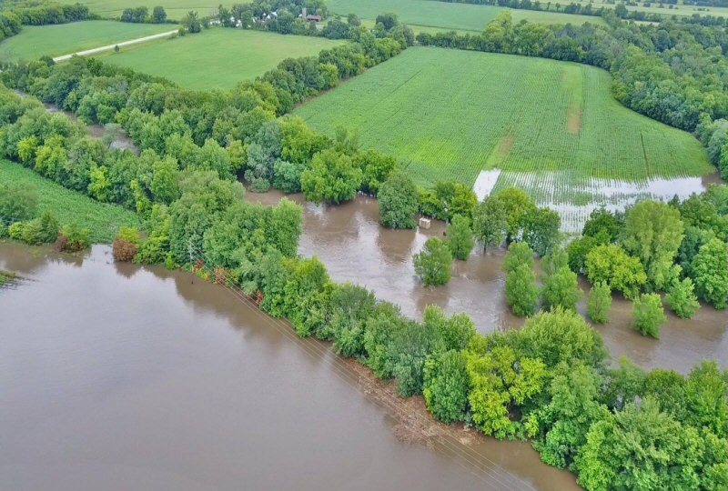
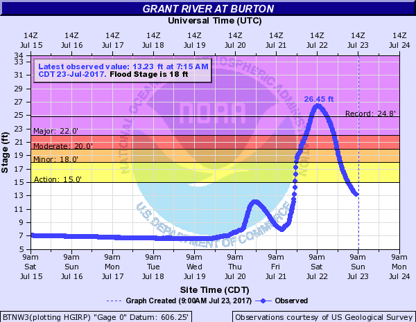
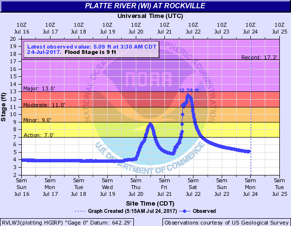
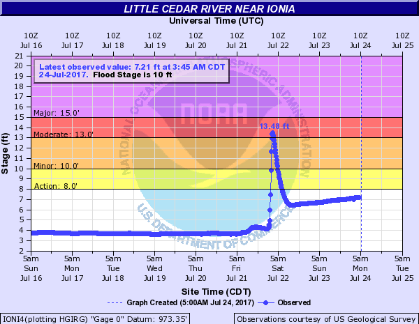
Two rounds of thunderstorms with very heavy rainfall impacted portions of northeast Iowa and southwest Wisconsin Friday, July 21 into the early morning hours of Saturday, July 22. Rainfall amounts across Floyd, Chickasaw, Fayette, and Clayton Counties in northeast Iowa and Grant County in far southwest Wisconsin ranged from 5 to 10 inches. This resulted in significant impacts, including flash flooding, river flooding, rock and mudslides, as well as numerous road washouts. Major flooding occurred along the Turkey, Volga, Little Wapsipinicon, and Grant Rivers, resulting in some evacuations for impacted communities. |
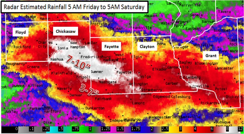 Radar estimated precipitation from 5 AM July 21 through 5 AM July 22, 2017 |
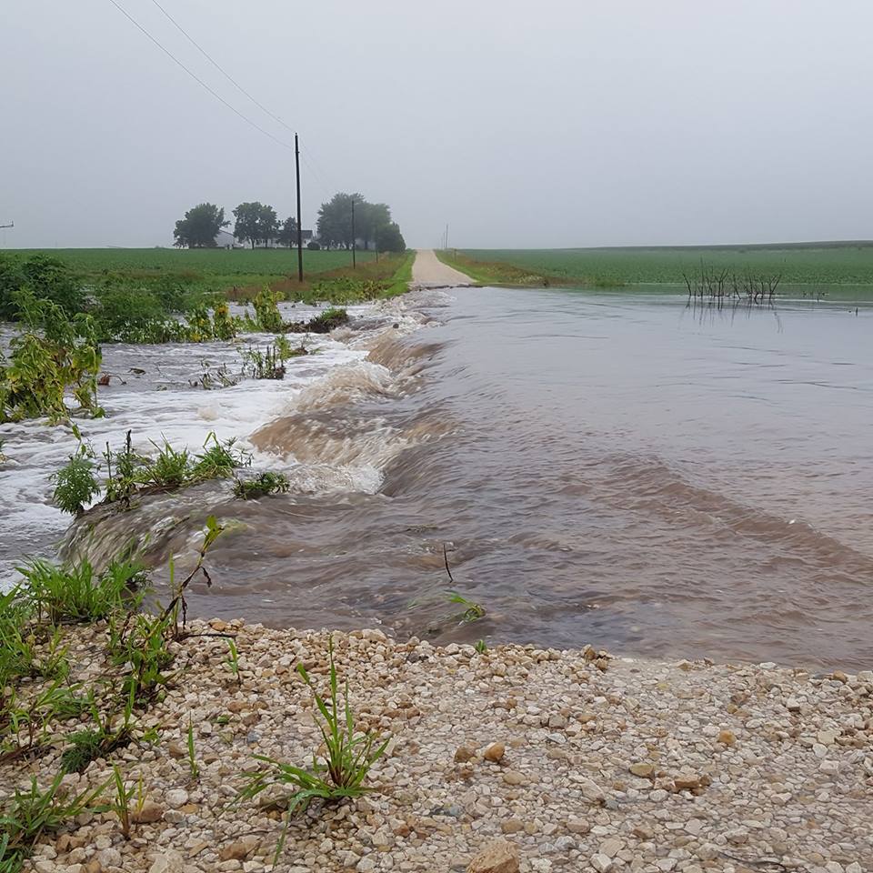
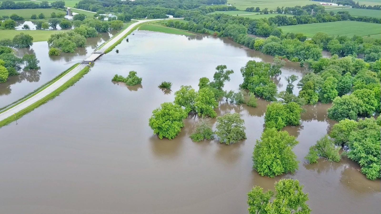
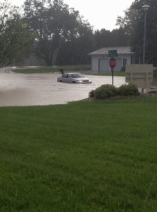
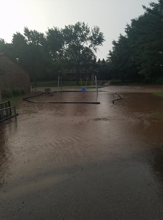
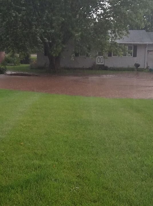
Photos:
 |
 |
 |
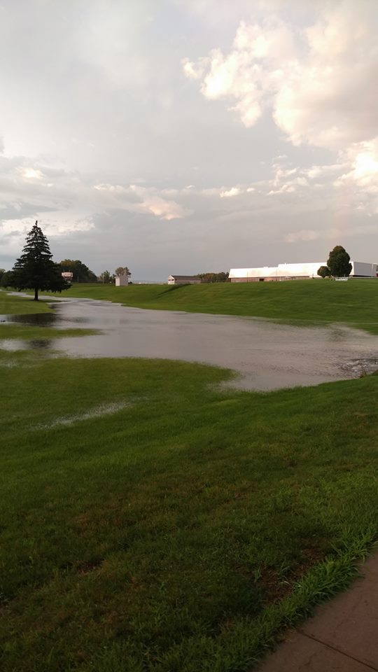 |
| Southern Floyd County (Photo by June Fitzner) |
Twin Bridges Park Fayette County (Photo by Ryan Langreck) |
Platteville, WI (Photo by Kiley Harris) |
Platteville, WI near High School (Photo by Will LeSuer) |
 |
 |
 |
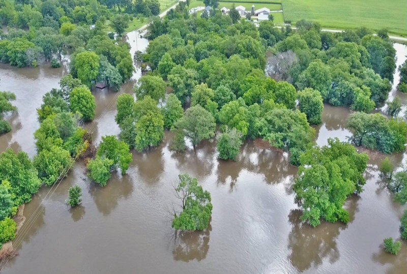 |
| Platteville, WI (Photo by Kiley Harris) |
Platteville, WI (Photo by Kiley Harris) |
Twin Bridges Park in Fayette County, IA (Photo by Ryan Langreck) |
Twin Bridges Park in Fayette County, IA (Photo by Ryan Langreck) |
Radar:
 |
 |
||
| July 21 Morning Radar | July 21 Evening Radar | Caption | Caption |
Storm Reports
PRELIMINARY LOCAL STORM REPORT
NATIONAL WEATHER SERVICE LA CROSSE WI
247 PM CDT SAT JUL 22 2017

..TIME...   ...EVENT...      ...CITY LOCATION...     ...LAT.LON...
..DATE...   ....MAG....      ..COUNTY LOCATION..ST.. ...SOURCE....
            ..REMARKS..

0328 AM     HEAVY RAIN       FREDERICKSBURG          42.97N 92.20W
07/22/2017  E10.00 INCH      CHICKASAW          IA   PUBLIC

            REPORT RELAYED BY BROADCAST MEDIA.

0645 AM     HEAVY RAIN       2 SSE BASSETT           43.03N 92.50W
07/22/2017  M8.39 INCH       CHICKASAW          IA   CO-OP OBSERVER

            CO-OP OBSERVER STATION IONI4, IONIA 2W.

1000 AM     HEAVY RAIN       NEW HAMPTON             43.06N 92.32W
07/22/2017  M8.35 INCH       CHICKASAW          IA   PUBLIC

            TOTAL SINCE 6 AM FRIDAY.

0700 AM     HEAVY RAIN       1 NW FAYETTE            42.85N 91.82W
07/22/2017  M7.67 INCH       FAYETTE            IA   CO-OP OBSERVER

            CO-OP OBSERVER STATION FYTI4, FAYETTE.

0621 AM     HEAVY RAIN       2 NNW FAYETTE           42.87N 91.82W
07/22/2017  M7.50 INCH       FAYETTE            IA   AMATEUR RADIO

            STORM TOTAL.

0230 AM     HEAVY RAIN       GUTTENBERG              42.79N 91.10W
07/22/2017  M7.44 INCH       CLAYTON            IA   PUBLIC


0900 AM     HEAVY RAIN       3 NW BURTON             42.75N 90.85W
07/22/2017  M7.20 INCH       GRANT              WI   PUBLIC

            STORM TOTAL.

0700 AM     HEAVY RAIN       NEW HAMPTON             43.06N 92.32W
07/22/2017  M7.00 INCH       CHICKASAW          IA   PUBLIC

            STORM TOTAL.

0700 AM     HEAVY RAIN       1 SSE CHARLES CITY      43.06N 92.67W
07/22/2017  M6.63 INCH       FLOYD              IA   CO-OP OBSERVER

            CO-OP OBSERVER STATION CIYI4, CHARLES CITY.

0737 AM     HEAVY RAIN       1 S NEW HAMPTON         43.05N 92.31W
07/22/2017  M6.35 INCH       CHICKASAW          IA   CO-OP OBSERVER


0600 AM     HEAVY RAIN       1 ESE GUTTENBERG        42.78N 91.10W
07/22/2017  M6.23 INCH       CLAYTON            IA   CO-OP OBSERVER

            CO-OP OBSERVER STATION GTTI4, GUTTENBERG DAM
            10.

0730 AM     HEAVY RAIN       CHARLES CITY            43.06N 92.67W
07/22/2017  M6.01 INCH       FLOYD              IA   MESONET

            MESONET STATION CCYI4, CHARLES CITY-CEDAR
            RIVER.

0700 AM     HEAVY RAIN       NEW HAMPTON             43.06N 92.32W
07/22/2017  M5.99 INCH       CHICKASAW          IA   COCORAHS

            COCORAHS STATION IA-CW-2, NEW HAMPTON.

0735 AM     HEAVY RAIN       FAYETTE                 42.84N 91.80W
07/22/2017  M5.63 INCH       FAYETTE            IA   MESONET

            MESONET STATION E2110, FAYETTE-CWOP.

0700 AM     HEAVY RAIN       NEW HAMPTON             43.06N 92.32W
07/22/2017  M5.58 INCH       CHICKASAW          IA   COCORAHS

            COCORAHS STATION IA-CW-3, NEW HAMPTON.

0724 AM     HEAVY RAIN       1 N NASHUA              42.97N 92.54W
07/22/2017  M5.44 INCH       CHICKASAW          IA   PUBLIC


0600 AM     HEAVY RAIN       2 WSW NASHUA            42.94N 92.57W
07/22/2017  M5.23 INCH       FLOYD              IA   CO-OP OBSERVER

            CO-OP OBSERVER STATION NHUI4, NASHUA 2SW.

0600 AM     HEAVY RAIN       1 ENE VOLGA             42.81N 91.52W
07/22/2017  M5.15 INCH       CLAYTON            IA   CO-OP OBSERVER

            CO-OP OBSERVER STATION VOLI4, VOLGA 1NE.

0655 AM     HEAVY RAIN       3 E CHARLES CITY        43.07N 92.61W
07/22/2017  M5.01 INCH       FLOYD              IA   AWOS

            AWOS STATION CCY, CHARLES CITY AIRPORT.

0900 PM     HEAVY RAIN       2 NNW FAYETTE           42.87N 91.82W
07/21/2017  M4.50 INCH       FAYETTE            IA   PUBLIC


0715 AM     HEAVY RAIN       GARBER                  42.74N 91.26W
07/22/2017  M4.38 INCH       CLAYTON            IA   MESONET

            MESONET STATION GRBI4, GARBER.

0740 AM     HEAVY RAIN       EDGEWOOD                42.64N 91.40W
07/22/2017  M4.36 INCH       CLAYTON            IA   TRAINED SPOTTER


0853 AM     HEAVY RAIN       1 W OELWEIN             42.68N 91.93W
07/22/2017  M4.06 INCH       FAYETTE            IA   TRAINED SPOTTER

            STORM TOTAL.

0645 AM     HEAVY RAIN       LITTLEPORT              42.75N 91.37W
07/22/2017  M3.99 INCH       CLAYTON            IA   MESONET

            MESONET STATION VLPI4, LITTLEPORT.

0225 AM     HEAVY RAIN       3 E CHARLES CITY        43.07N 92.61W
07/22/2017  M3.84 INCH       FLOYD              IA   PUBLIC


0700 AM     HEAVY RAIN       2 S AUSTIN              43.64N 92.97W
07/22/2017  M3.76 INCH       MOWER              MN   MESONET

            MESONET STATION ASNM5, AUSTIN 3S.

1000 AM     HEAVY RAIN       LANCASTER               42.85N 90.71W
07/22/2017  M3.62 INCH       GRANT              WI   PUBLIC

            STORM TOTAL.

0915 PM     HEAVY RAIN       AUSTIN                  43.68N 92.97W
07/21/2017  M3.62 INCH       MOWER              MN   PUBLIC

            RAIN TOTAL FROM 7 AM TO 9 PM.

0738 AM     HEAVY RAIN       1 W PLATTEVILLE         42.74N 90.49W
07/22/2017  M3.60 INCH       GRANT              WI   TRAINED SPOTTER


0700 AM     HEAVY RAIN       PLATTEVILLE             42.74N 90.47W
07/22/2017  M3.27 INCH       GRANT              WI   COCORAHS

            COCORAHS STATION WI-GT-2, PLATTEVILLE.

0654 AM     HEAVY RAIN       2 ESE AUSTIN            43.66N 92.93W
07/22/2017  M3.26 INCH       MOWER              MN   AWOS

            AWOS STATION AUM, AUSTIN MUNICIPAL AIRPORT.

0645 AM     HEAVY RAIN       1 E ELDORADO            43.05N 91.81W
07/22/2017  M3.15 INCH       FAYETTE            IA   MESONET

            MESONET STATION EDRI4, ELDORADO.

0730 AM     HEAVY RAIN       1 ESE AUSTIN            43.67N 92.95W
07/22/2017  M3.09 INCH       MOWER              MN   CO-OP OBSERVER

            CO-OP OBSERVER STATION DOBM5, AUSTIN
            2NE-DOBBINS CREEK.

1146 PM     HEAVY RAIN       GLEN HAVEN              42.83N 91.07W
07/21/2017  E3.00 INCH       GRANT              WI   LAW ENFORCEMENT

            3 INCHES OF RAIN IN 1.5 HOURS.

0700 AM     HEAVY RAIN       4 WSW SAINT OLAF        42.91N 91.47W
07/22/2017  M2.83 INCH       CLAYTON            IA   MESONET

            MESONET STATION BSHI4, ELKADER 5NW.

0630 AM     HEAVY RAIN       2 SSW AUSTIN            43.65N 92.98W
07/22/2017  M2.67 INCH       MOWER              MN   CO-OP OBSERVER

            CO-OP OBSERVER STATION TRCM5, AUSTIN 3 NW -
            TURTLE CREEK.

0655 AM     HEAVY RAIN       3 W OELWEIN             42.68N 91.97W
07/22/2017  M2.63 INCH       FAYETTE            IA   AWOS

            AWOS STATION OLZ, OELWEIN MUNICIPAL AIRPORT.

0655 AM     HEAVY RAIN       2 SSE PRAIRIE DU CHIEN  43.02N 91.12W
07/22/2017  M2.45 INCH       CRAWFORD           WI   AWOS

            AWOS STATION PDC, PRAIRIE DU CHIEN AIRPORT.

0645 AM     HEAVY RAIN       2 W OSAGE               43.28N 92.85W
07/22/2017  M2.43 INCH       MITCHELL           IA   CO-OP OBSERVER

            CO-OP OBSERVER STATION OSGI4, OSAGE.

0645 AM     HEAVY RAIN       3 SSE ROCKFORD          43.01N 92.93W
07/22/2017  M2.40 INCH       FLOYD              IA   MESONET

            MESONET STATION RKFI4, ROCKFORD-SHELL ROCK
            RVR.

0219 AM     HEAVY RAIN       3 W OELWEIN             42.68N 91.98W
07/22/2017  M2.13 INCH       FAYETTE            IA   PUBLIC


0655 AM     HEAVY RAIN       4 SSE PLATTEVILLE       42.69N 90.44W
07/22/2017  M2.11 INCH       GRANT              WI   AWOS

            AWOS STATION PVB, PLATTEVILLE MUNICIPAL
            AIRPORT.

0700 AM     HEAVY RAIN       1 SW MONONA             43.04N 91.40W
07/22/2017  M2.08 INCH       CLAYTON            IA   CO-OP OBSERVER

            CO-OP OBSERVER STATION MNOI4, MONONA WWTP.

0615 AM     HEAVY RAIN       2 NE CRESCO             43.39N 92.09W
07/22/2017  M1.68 INCH       HOWARD             IA   CO-OP OBSERVER

            CO-OP OBSERVER STATION CRCI4, CRESCO 1NE.

0733 AM     HEAVY RAIN       4 NE RICEVILLE          43.40N 92.50W
07/22/2017  M1.35 INCH       HOWARD             IA   MESONET

            MESONET STATION E4652, 3 NE RICEVILLE.

0700 AM     HEAVY RAIN       1 WSW HILLSBORO         43.65N 90.35W
07/22/2017  M1.26 INCH       VERNON             WI   CO-OP OBSERVER

            CO-OP OBSERVER STATION HBOW3, HILLSBORO WSW.

0516 PM     HAIL             3 NE CASSVILLE          42.75N 90.96W
07/21/2017  E1.25 INCH       GRANT              WI   PUBLIC


0630 AM     HEAVY RAIN       SAINT ANSGAR            43.38N 92.92W
07/22/2017  M1.24 INCH       MITCHELL           IA   CO-OP OBSERVER

            CO-OP OBSERVER STATION SANI4, ST ANSGAR.

0703 AM     HEAVY RAIN       1 ENE BOSCOBEL          43.15N 90.68W
07/22/2017  M1.24 INCH       GRANT              WI   MESONET

            MESONET STATION BBLW3, 1 ENE BOSCOBEL.

0700 AM     HEAVY RAIN       READSTOWN               43.45N 90.76W
07/22/2017  M1.11 INCH       VERNON             WI   MESONET

            MESONET STATION REAW3, READSTOWN.

0645 AM     HEAVY RAIN       5 SW WAUKON JCT         43.11N 91.26W
07/22/2017  M1.06 INCH       ALLAMAKEE          IA   MESONET

            MESONET STATION YRII4, 4 ENE WATSON.

0700 AM     HEAVY RAIN       1 NNW SPRING VALLEY     43.69N 92.39W
07/22/2017  M1.04 INCH       FILLMORE           MN   CO-OP OBSERVER

            CO-OP OBSERVER STATION SPGM5, SPRING VALLEY.

0651 AM     HEAVY RAIN       2 NE BOSCOBEL           43.16N 90.67W
07/22/2017  M1.03 INCH       GRANT              WI   ASOS

            ASOS STATION OVS, BOSCOBEL AIRPORT.

0517 PM     HAIL             2 E CASSVILLE           42.72N 90.95W
07/21/2017  E0.75 INCH       GRANT              WI   FIRE DEPT/RESCUE


1138 PM     HAIL             WEST UNION              42.96N 91.81W
07/21/2017  E0.75 INCH       FAYETTE            IA   PUBLIC


1135 PM     FLASH FLOOD      GUTTENBERG              42.79N 91.10W
07/21/2017                   CLAYTON            IA   LAW ENFORCEMENT

            NUMEROUS ROAD CLOSURES DUE TO INUNDATION,
            ROCK SLIDES AND MUD SLIDES.

0922 PM     FLASH FLOOD      1 E ELKADER             42.86N 91.38W
07/21/2017                   CLAYTON            IA   LAW ENFORCEMENT

            GRAPE ROAD WASHED OUT.

1148 PM     FLASH FLOOD      PLATTEVILLE             42.74N 90.48W
07/21/2017                   GRANT              WI   LAW ENFORCEMENT

            NUMEROUS STREETS FLOODED, MANY HOUSES
            SURROUNDED BY WATER AND BASEMENTS FLOODED.

0127 AM     FLASH FLOOD      CASSVILLE               42.72N 90.99W
07/22/2017                   GRANT              WI   PUBLIC

            GRANT COUNTY EMERGENCY MANAGEMENT REPORTS 3
            CARS SWEPT AWAY BY FLOODWATERS IN CASSVILLE.

0151 AM     FLASH FLOOD      1 E FREDERICKSBURG      42.97N 92.17W
07/22/2017                   CHICKASAW          IA   LAW ENFORCEMENT

            WATER WAS REPORTED OVER HIGHWAY 18.
            SANDBAGGING WAS ONGOING IN NEW HAMPTON.

0300 AM     FLASH FLOOD      5 SW BASSETT            43.02N 92.59W
07/22/2017                   FLOYD              IA   PUBLIC

            PARTIAL WASHOUT OF RAILROAD CROSSING NEAR
            THE INTERSECTION OF WALNUT AVENUE AND 230TH
            STREET.

1243 AM     FLASH FLOOD      1 WNW GUTTENBERG        42.80N 91.13W
07/22/2017                   CLAYTON            IA   EMERGENCY MNGR

            3 RESIDENTIAL RESCUES UNDERWAY. ONE ON SOUTH
            CEDAR CREEK NEAR COUNTY RD. C7X AND OTHERS
            ON MINERS CREEK RD.

0300 AM     FLASH FLOOD      5 NW NASHUA             43.01N 92.60W
07/22/2017                   FLOYD              IA   PUBLIC

            PARTIAL WASHOUT OF A ROAD NEAR THE
            INTERSECTION OF 240TH STREET AND VISTA LANE.

0306 AM     FLASH FLOOD      GUTTENBERG              42.79N 91.11W
07/22/2017                   CLAYTON            IA   EMERGENCY MNGR

            MULTIPLE ROADS CLOSED ACROSS THE COUNTY DUE
            TO FLOODING. MAJOR FLOODING IN SPOTS.
            HARDEST HIT AREA IS FROM GARBER TO
            GUTTENBERG.

1255 AM     FLASH FLOOD      CASSVILLE               42.72N 90.99W
07/22/2017                   GRANT              WI   LAW ENFORCEMENT

            PARTS OF HIGHWAY 81 BETWEEN BEETOWN AND
            CASSVILLE HAVE BEEN WASHED OUT. ALSO,
            CURRENTLY 5 PEOPLE TRAPPED DUE TO HIGH WATER
            IN RESIDENCES NEAR CASSVILLE.

0750 PM     FLASH FLOOD      GLEN HAVEN              42.83N 91.07W
07/21/2017                   GRANT              WI   EMERGENCY MNGR

            NUMEROUS ROAD CLOSURES THROUGHOUT THE COUNTY
            DUE TO FLOODING.
Rain Reports
Public Information Statement
National Weather Service La Crosse WI
319 PM CDT Sat Jul 22 2017

...Rainfall Reports...

Location                     Amount    Time/Date       Lat/Lon

...Iowa...

...Allamakee County...
4 ENE Watson                 0.71 in   0245 PM 07/22   43.11N/91.26W

...Chickasaw County...
New Hampton                  8.35 in   1000 AM 07/22   43.05N/92.33W
Ionia 2W                     6.62 in   0245 PM 07/22   43.03N/92.50W
New Hampton                  5.99 in   0700 AM 07/22   43.06N/92.32W
Fredericksburg               4.82 in   0700 AM 07/22

...Clayton County...
Guttenberg Dam 10            6.23 in   0800 AM 07/22   42.78N/91.10W
Volga 1NE                    5.15 in   0600 AM 07/22   42.81N/91.52W
Garber                       3.15 in   0215 PM 07/22   42.74N/91.26W
Littleport                   2.98 in   0245 PM 07/22   42.75N/91.37W
Monona WWTP                  2.08 in   0700 AM 07/22   43.04N/91.40W
Elkader 5NW                  1.71 in   0300 PM 07/22   42.91N/91.47W
Marquette                    1.63 in   0800 AM 07/22   43.05N/91.18W
Marquette-Bloody Run Creek   0.38 in   0300 PM 07/22   43.04N/91.21W

...Fayette County...
Fayette                      7.67 in   0700 AM 07/22   42.85N/91.82W
1 ENE Alpha                  4.91 in   0900 AM 07/22   43.01N/92.03W
Waucoma 1WNW                 4.27 in   0700 AM 07/22   43.06N/92.05W
Oelwein                      4.06 in   0700 AM 07/22   42.68N/91.93W
Fayette-CWOP                 3.06 in   0305 PM 07/22   42.84N/91.80W
Oelwein Municipal Airport    2.63 in   0655 AM 07/22   42.68N/91.97W
Eldorado                     1.36 in   0245 PM 07/22   43.05N/91.81W

...Floyd County...
Charles City                 6.63 in   0700 AM 07/22   43.06N/92.67W
Charles City-Cedar River     5.29 in   0230 PM 07/22   43.06N/92.67W
Nashua 2sw                   5.23 in   0600 AM 07/22   42.94N/92.57W
Charles City Airport         5.01 in   0655 AM 07/22   43.07N/92.61W
Rockford-Shell Rock Rvr      1.58 in   0245 PM 07/22   43.01N/92.93W
Nora Springs 2.4 SSE         0.83 in   0700 AM 07/22   43.11N/92.99W

...Howard County...
Cresco 1NE                   1.68 in   0615 AM 07/22   43.39N/92.09W

...Mitchell County...
St Ansgar                    1.24 in   0630 AM 07/22   43.38N/92.92W
Osage                        0.09 in   0245 PM 07/22   43.28N/92.85W

...Winneshiek County...
Calmar NE                    2.21 in   0700 AM 07/22   43.19N/91.86W
Decorah Municipal Airport    0.58 in   0655 AM 07/22   43.28N/91.74W
5 ESE Decorah                0.58 in   0700 AM 07/22   43.26N/91.70W
7 ENE Decorah                0.52 in   0835 AM 07/22   43.34N/91.64W

...Minnesota...

...Dodge County...
Hayfield                     0.47 in   0830 AM 07/22   43.89N/92.85W
2 E Claremont                0.44 in   0800 AM 07/22   44.04N/92.95W
2 NE Kasson                  0.25 in   0700 AM 07/22   44.05N/92.72W
Wasioja Alert Gage           0.12 in   0902 AM 07/22   44.07N/92.82W

...Fillmore County...
Spring Valley 3sw            1.20 in   0700 AM 07/22   43.66N/92.41W
Spring Valley                1.04 in   0700 AM 07/22   43.69N/92.39W
Spring Valley 3E             0.97 in   0700 AM 07/22   43.68N/92.33W
1 W Fillmore                 0.57 in   0700 AM 07/22   43.74N/92.31W
Lanesboro 2NE                0.54 in   0700 AM 07/22   43.73N/91.94W
Preston                      0.54 in   0700 AM 07/22   43.66N/92.08W
1 SSE Pilot Mound            0.53 in   0700 AM 07/22   43.79N/92.03W
Preston                      0.52 in   0800 AM 07/22   43.67N/92.07W
Mabel                        0.51 in   0700 AM 07/22   43.52N/91.76W
Preston Airport              0.38 in   0652 AM 07/22   43.68N/92.18W

...Houston County...
Caledonia                    0.59 in   0700 AM 07/22   43.63N/91.50W
Hokah WWTP                   0.55 in   0700 AM 07/22   43.76N/91.35W
Houston                      0.05 in   0245 PM 07/22   43.77N/91.57W

...Mower County...
Austin Municipal Airport     3.26 in   0654 AM 07/22   43.66N/92.93W
1 ENE Austin                 0.25 in   0900 AM 07/22   43.68N/92.94W

...Olmsted County...
Elgin 2ssw                   0.42 in   0700 AM 07/22   44.10N/92.27W
2 W High Forest              0.41 in   0700 AM 07/22   43.85N/92.59W
Rochester Ap 2ne             0.41 in   0700 AM 07/22   43.93N/92.48W
2 NNW Rochester              0.40 in   0700 AM 07/22   44.05N/92.49W
2 NE Rochester               0.36 in   0600 AM 07/22   44.04N/92.44W
4 NNW Rochester              0.36 in   0700 AM 07/22   44.07N/92.49W
4 ESE Douglas                0.36 in   0700 AM 07/22   44.08N/92.48W
2 N Rock Dell                0.35 in   0800 AM 07/22   43.96N/92.63W
Rochester International Airp 0.34 in   0654 AM 07/22   43.91N/92.50W
Mayo Helipad                 0.30 in   0652 AM 07/22   44.02N/92.48W
Byron 4 North                0.28 in   0700 AM 07/22   44.09N/92.64W
5 E Douglas                  0.20 in   0730 AM 07/22   44.10N/92.47W
2 NE Rochester               0.05 in   1200 PM 07/22   44.04N/92.45W

...Wabasha County...
3 SW Zumbro Falls            0.48 in   0700 AM 07/22   44.24N/92.46W
Theilman 1SSW                0.44 in   0830 AM 07/22   44.28N/92.19W
1 SSE Lake City              0.22 in   0800 AM 07/22   44.43N/92.27W
Wabasha                      0.15 in   0700 AM 07/22   44.38N/92.05W
Lake City                    0.12 in   0800 AM 07/22   44.44N/92.28W
Kellogg-Zumbro River         0.06 in   0300 PM 07/22   44.32N/92.00W

...Winona County...
La Crescent Dam 7            0.60 in   0800 AM 07/22   43.87N/91.31W
Lewiston                     0.52 in   0700 AM 07/22   43.99N/91.87W
Altura 5w                    0.48 in   0700 AM 07/22   44.06N/92.04W
2 NNW Pickwick               0.48 in   0700 AM 07/22   44.02N/91.61W
Stockton                     0.43 in   0700 AM 07/22   44.03N/91.77W
Minnesota City Dam 5         0.38 in   0800 AM 07/22   44.16N/91.81W
1 ESE Minnesota City         0.33 in   0700 AM 07/22   44.08N/91.73W
Winona Dam 5A                0.31 in   0800 AM 07/22   44.09N/91.67W
Dakota                       0.10 in   0215 PM 07/22   43.91N/91.36W

...Wisconsin...

...Adams County...
Castle Rock                  0.30 in   0700 AM 07/22   43.87N/89.95W
Friendship                   0.18 in   0700 AM 07/22   43.98N/89.83W
Petenwell Lake               0.13 in   0600 AM 07/22   44.08N/90.00W

...Buffalo County...
Alma Dam 4                   0.32 in   0800 AM 07/22   44.33N/91.92W

...Crawford County...
Prairie Du Chien  Airport    2.45 in   0655 AM 07/22   43.02N/91.12W
1 WNW Mount Zion             1.04 in   0700 AM 07/22   43.26N/90.76W
Lynxville Dam 9              0.85 in   0600 AM 07/22   43.21N/91.10W
De Soto 1SE                  0.85 in   0700 AM 07/22   43.42N/91.19W
Steuben                      0.36 in   0245 PM 07/22   43.18N/90.86W
De Soto                      0.10 in   0256 PM 07/22   43.42N/91.19W

...Grant County...
Beetown 4SE                  7.20 in   0900 AM 07/22   42.75N/90.86W
Sinsinawa                    4.36 in   0700 AM 07/22   42.52N/90.54W
Lancaster                    3.62 in   1000 AM 07/22
Platteville                  3.27 in   0700 AM 07/22   42.74N/90.47W
Platteville Municipal Airpor 2.11 in   0655 AM 07/22   42.69N/90.44W
Boscobel Airport             1.03 in   0651 AM 07/22   43.16N/90.67W
1 ENE Boscobel               0.88 in   0303 PM 07/22   43.15N/90.68W
Muscoda                      0.74 in   0245 PM 07/22   43.20N/90.44W

...Jackson County...
Black River Falls Area Airpo 0.15 in   0655 AM 07/22   44.25N/90.86W
Black River Falls Sewage     0.15 in   0830 AM 07/22   44.29N/90.85W
Black River Falls-black Rive 0.09 in   0715 AM 07/22   44.28N/90.87W
Mather 3nw                   0.07 in   0700 AM 07/22   44.17N/90.35W

...Juneau County...
Union Center                 0.83 in   0830 AM 07/22   43.68N/90.26W
2 WNW Wisconsin Dells        0.50 in   0310 PM 07/22   43.65N/89.82W
Mauston                      0.45 in   0307 PM 07/22   43.80N/90.07W
New Lisbon 4ene              0.26 in   0700 AM 07/22   43.91N/90.07W
2 W Dellwood                 0.25 in   0700 AM 07/22   43.99N/89.99W
Volk Field                   0.20 in   0658 AM 07/22   43.94N/90.25W
Necedah                      0.08 in   0248 PM 07/22   44.03N/90.08W
2 N Cloverdale               0.07 in   0310 PM 07/22   44.06N/90.17W

...La Crosse County...
La Crosse 4NNW               0.58 in   0730 AM 07/22   43.87N/91.27W
Holmen 2s                    0.57 in   0700 AM 07/22   43.93N/91.25W
La Crosse Regional Airport   0.56 in   0653 AM 07/22   43.88N/91.26W
La Crosse Weather Office     0.55 in   0600 AM 07/22   43.82N/91.19W
West Salem 2W                0.50 in   0700 AM 07/22   43.90N/91.12W
3 W Saint Joseph             0.26 in   0305 PM 07/22   43.78N/91.10W

...Monroe County...
Sparta                       0.36 in   0800 AM 07/22   43.94N/90.82W
Sparta/Fort McCoy Airport    0.31 in   0655 AM 07/22   43.96N/90.74W
Fort Mccoy- Stillwell Creek  0.26 in   0715 AM 07/22   44.00N/90.68W
Cataract                     0.20 in   0700 AM 07/22   44.08N/90.85W
Four Corners                 0.19 in   0700 AM 07/22   44.09N/90.91W
Warrens 4WSW                 0.18 in   0700 AM 07/22   44.10N/90.59W
2 E Cataract                 0.05 in   0308 PM 07/22   44.09N/90.79W

...Richland County...
Richland Center 4N           0.79 in   0600 AM 07/22   43.40N/90.39W

...Trempealeau County...
Trempealeau Dam 6            0.44 in   0800 AM 07/22   44.00N/91.44W
1 NW Trempealeau             0.44 in   0700 AM 07/22   44.03N/91.46W
1 NE Galesville              0.36 in   0700 AM 07/22   44.10N/91.34W
Ettrick 4WNW                 0.36 in   0615 AM 07/22   44.19N/91.34W
Osseo                        0.05 in   0700 AM 07/22   44.58N/91.22W

...Vernon County...
Hillsboro 2sw                2.55 in   0700 AM 07/22   43.63N/90.38W
Hillsboro WSW                1.26 in   0700 AM 07/22   43.65N/90.35W
Westby 3ENE                  0.99 in   0700 AM 07/22   43.67N/90.81W
La Farge                     0.80 in   0715 AM 07/22   43.57N/90.64W
Coon Valley                  0.69 in   0700 AM 07/22   43.70N/91.01W
Genoa Dam 8                  0.66 in   0800 AM 07/22   43.57N/91.23W
Viroqua                      0.65 in   0700 AM 07/22   43.56N/90.88W
Viroqua 0.8 ESE              0.64 in   0700 AM 07/22   43.55N/90.87W
Stoddard                     0.60 in   0700 AM 07/22   43.66N/91.22W
Viroqua Municipal Airport    0.59 in   0655 AM 07/22   43.58N/90.90W
3 WNW Viola                  0.58 in   0800 AM 07/22   43.53N/90.74W
Readstown                    0.52 in   0300 PM 07/22   43.45N/90.76W

Observations are collected from a variety of sources with varying
equipment and exposures. We thank all volunteer weather observers
for their dedication. Not all data listed are considered official.
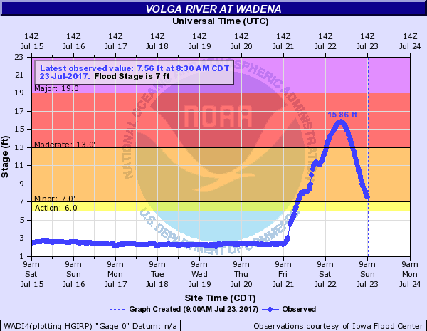
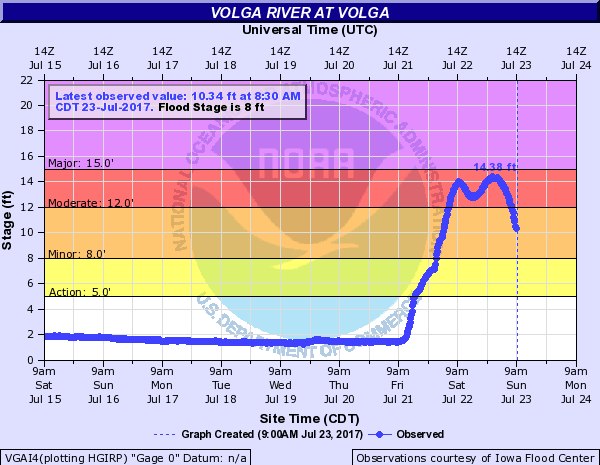
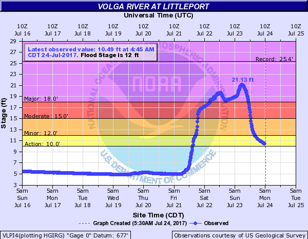
Hydrographs:
Grant River (WI): |
Platte River (WI): |
Little Cedar River (IA): |
Turkey River (IA): |
 |
 |
 |
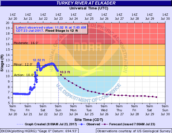 |
| Burton, WI | at Rockville, WI | Near Ionia, IA | Elkader, IA |
Volga River (IA): |
|||
 |
 |
 |
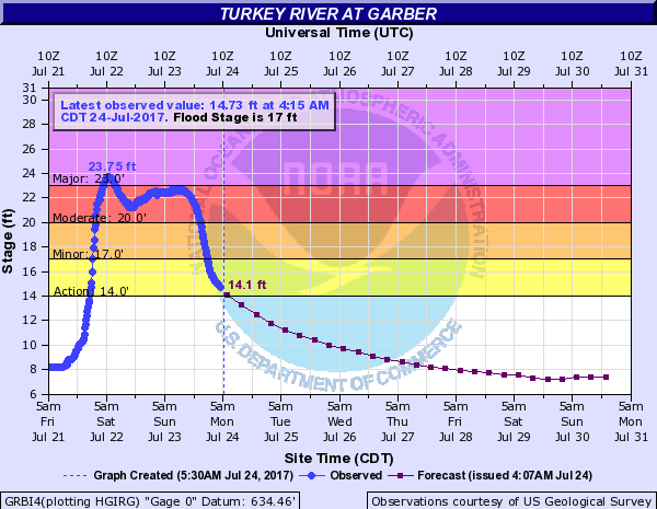 |
| Wadena, IA | Volga, IA | Littleport, IA | Garber, IA |
 |
Media use of NWS Web News Stories is encouraged! Please acknowledge the NWS as the source of any news information accessed from this site. |
|


 Weather Story
 Weather Map
 Local Radar