Overview
|
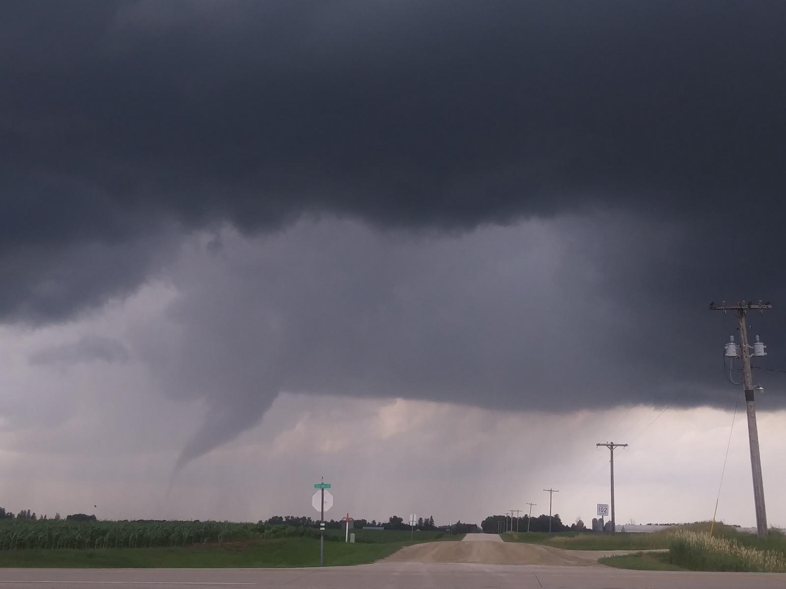
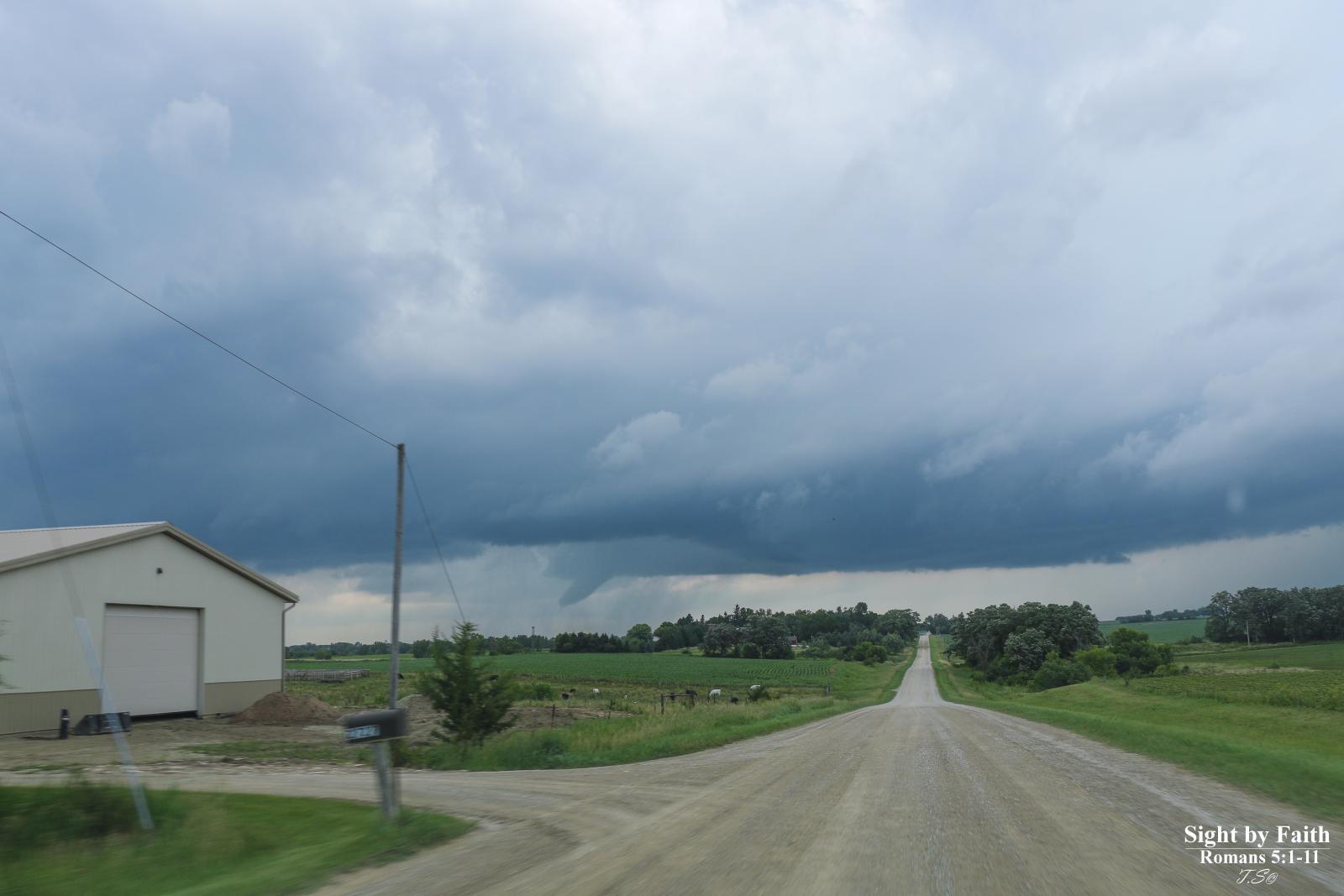
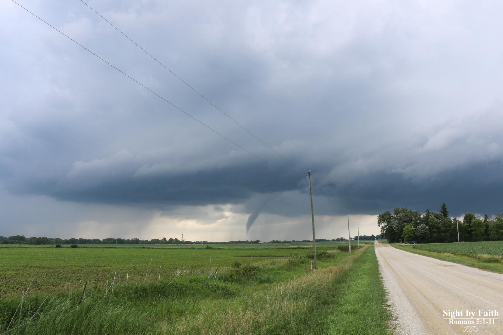
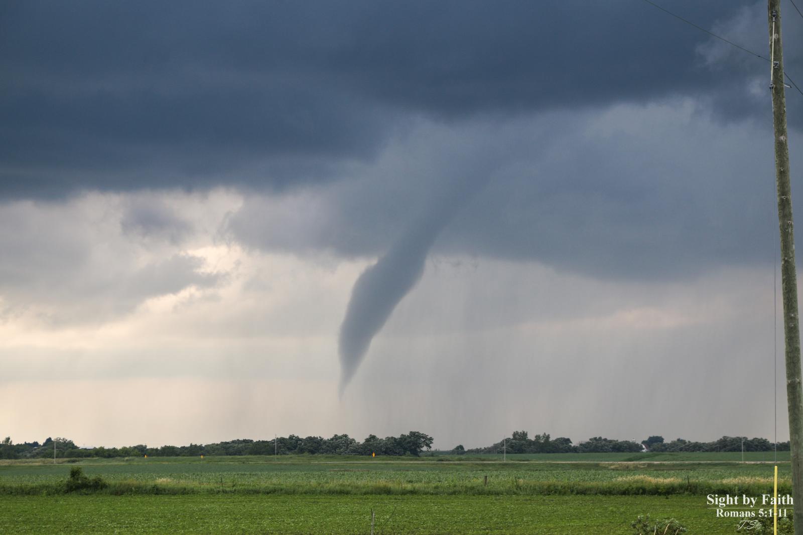
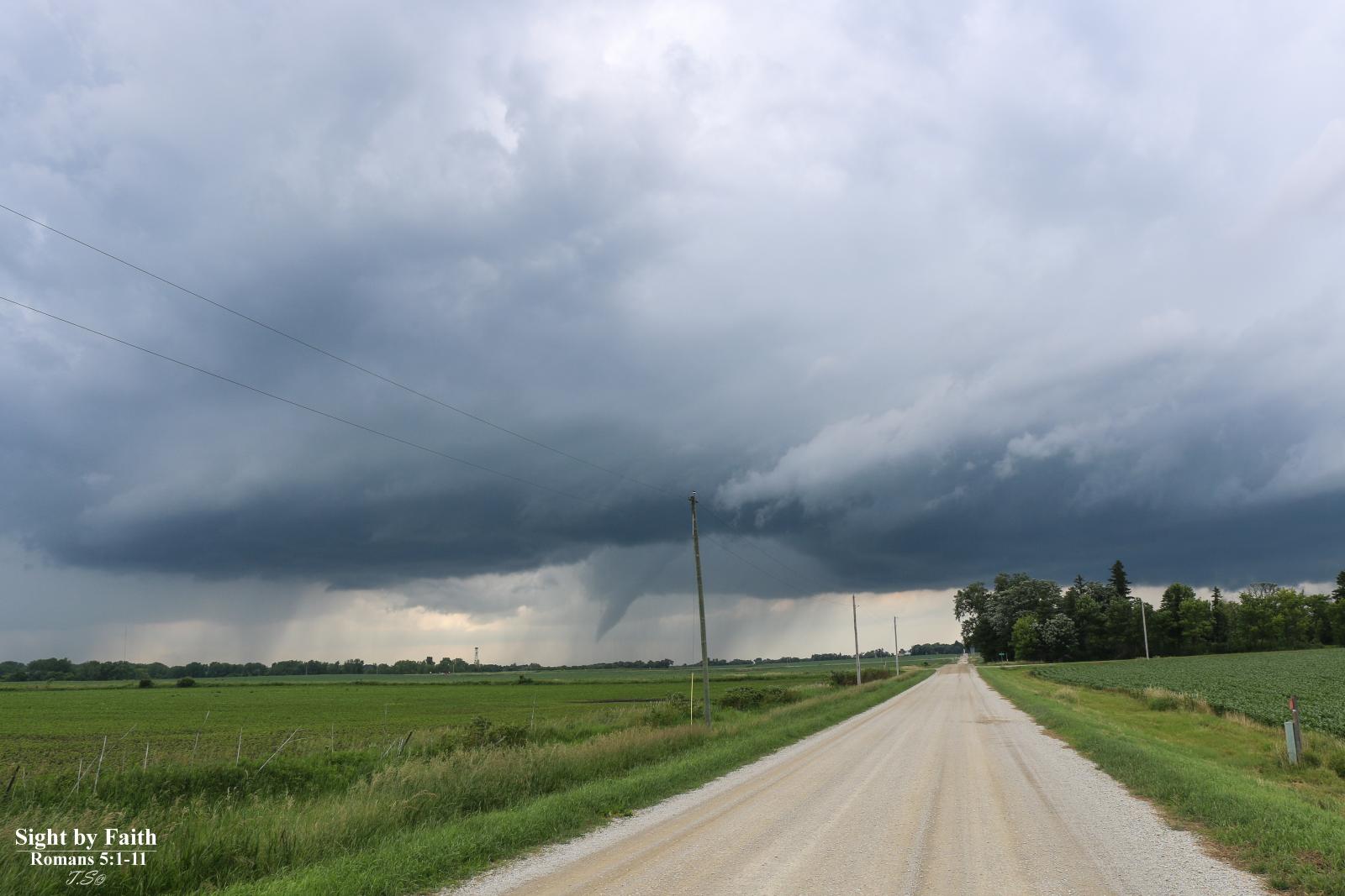
Several clusters of thunderstorms erupted during the afternoon hours of Wednesday, June 28, 2017 producing heavy rain, pockets of wind damage, funnel clouds, and two very brief tornadoes. Storms across northeast Iowa and southwest Wisconsin produced rainfall of 2 to 3 inches and wind gusts in the 50-80 mph range. This not only led to river and flash flooding and pockets of wind damage. |
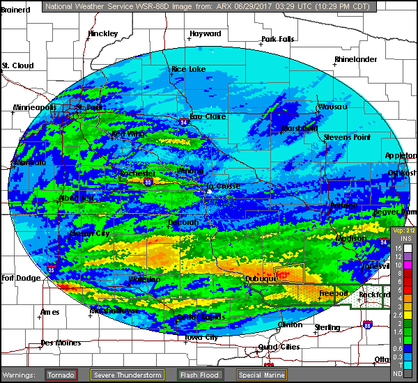
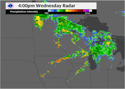 Radar loop between 4pm and 10pm on June 28th |
Tornadoes:
|
Tornado - Viola, Minnesota
Track Map .png)  |
||||||||||||||||
|
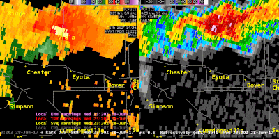
Tornado - Chester, Minnesota
Track Map 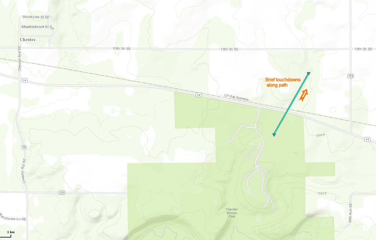 |
||||||||||||||||
The Enhanced Fujita (EF) Scale classifies tornadoes into the following categories:
| EF0 Weak 65-85 mph |
EF1 Moderate 86-110 mph |
EF2 Significant 111-135 mph |
EF3 Severe 136-165 mph |
EF4 Extreme 166-200 mph |
EF5 Catastrophic 200+ mph |
 |
|||||
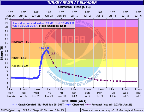
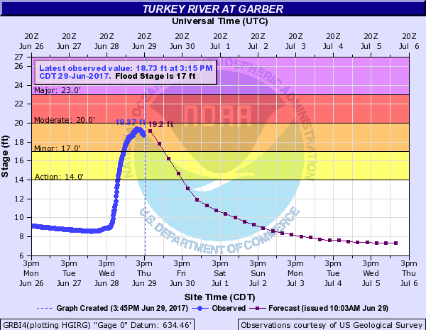
Flooding
Hydrographs will be updated as crests occur.
 |
 |
 |
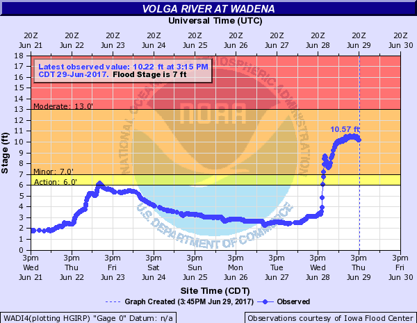 |
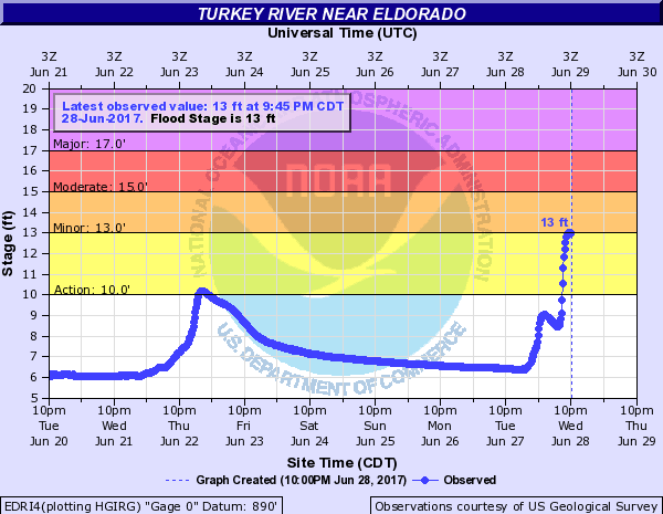
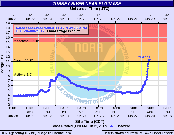
| Turkey River at Eldorado, IA | Turkey River at Elgin 6SE | Turkey River at Elkader, IA | Volga River at Wadena, IA |
 |
|||
| Turkey River at Garber, IA |
Photos:
 |
 |
 |
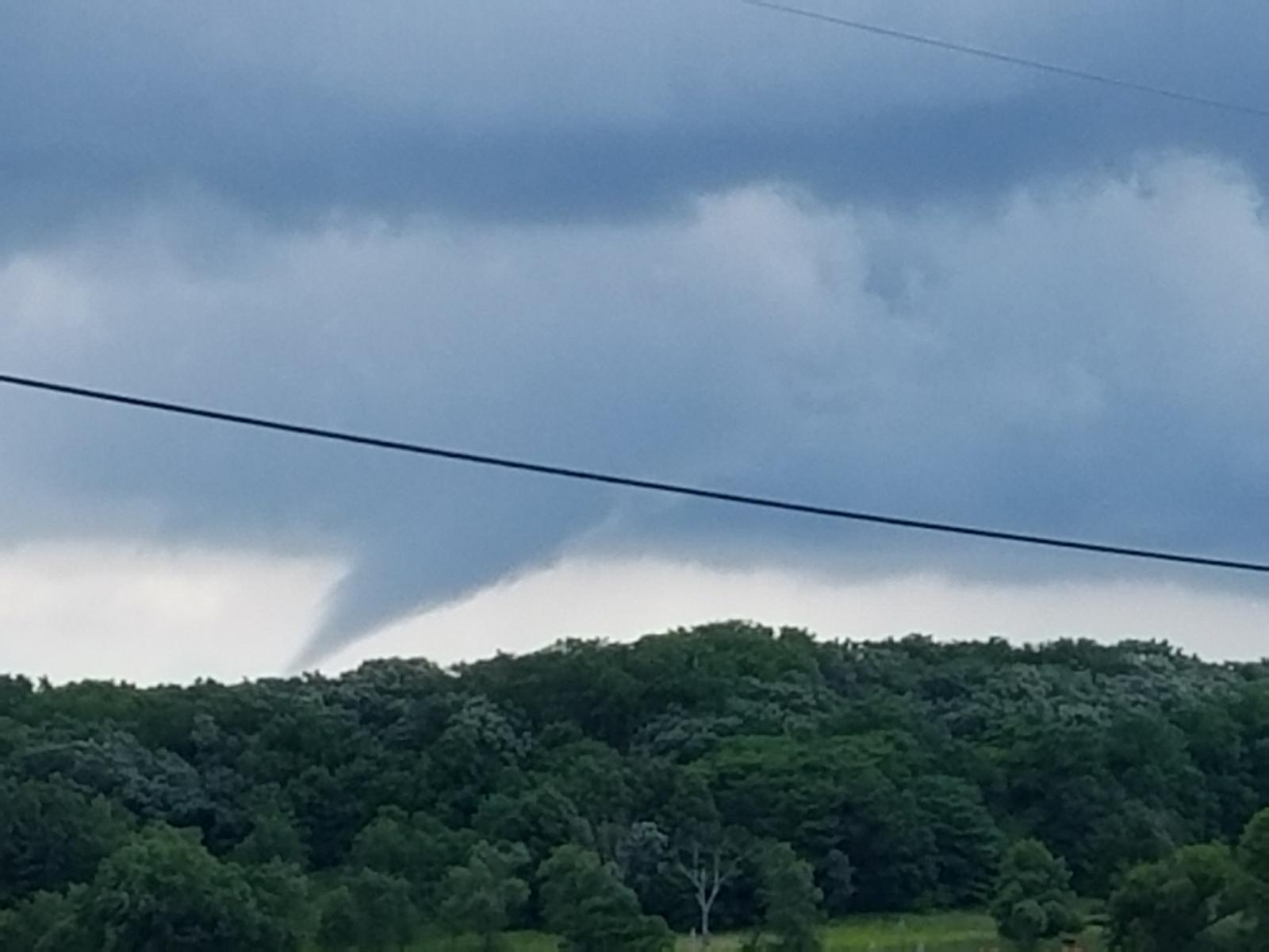 |
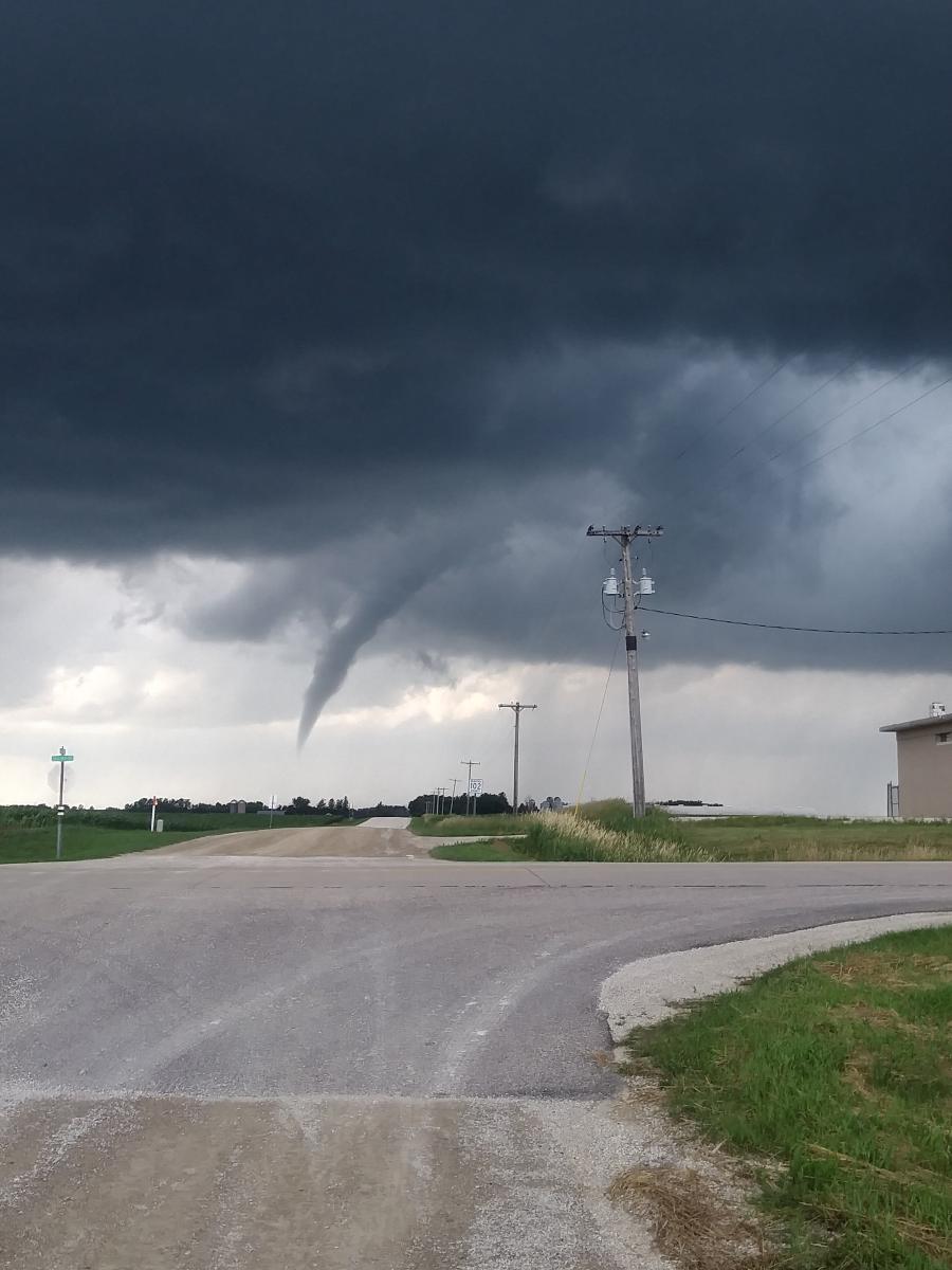
| Funnel cloud or brief tornado near Viola, MN (Photo by Jordan Manderfield) |
Funnel cloud or brief tornado near Viola, MN (Photo by Jordan Manderfield) |
Funnel cloud or brief tornado near Viola, MN (Photo by Jordan Manderfield) |
Funnel cloud or brief tornado near Viola, MN (Photo by Bob Wiles) |
 |
 |
 |
 |
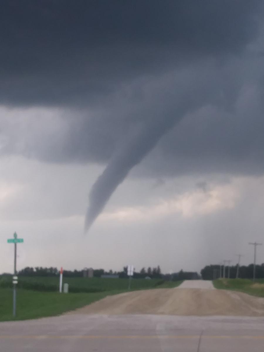
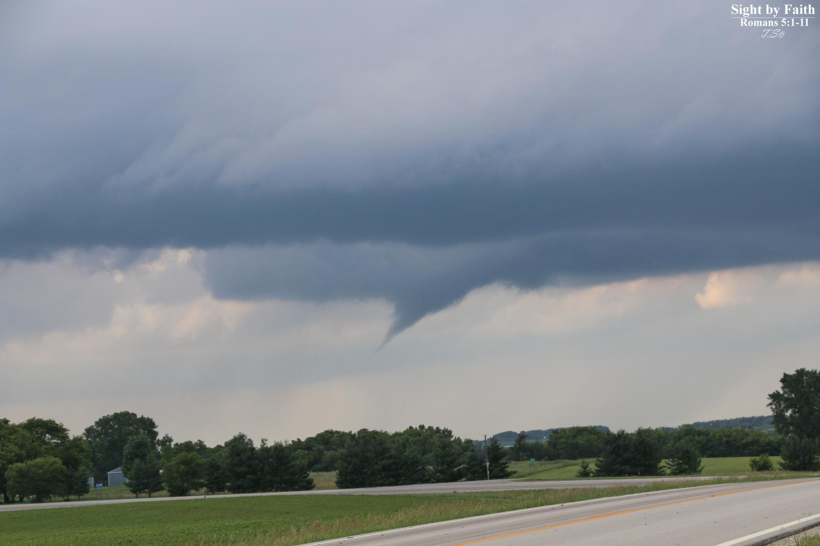
| Funnel cloud or brief tornado north of Dover, MN (Photo by Tanner Schaaf) |
Funnel cloud or brief tornado north of Dover, MN (Photo by Tanner Schaaf) |
Funnel cloud or brief tornado north of Dover, MN (Photo by Tanner Schaaf) |
Funnel cloud or brief tornado north of Dover, MN (Photo by Tanner Schaaf) |
 |
 |
 |
|
| Funnel cloud or brief tornado north of Dover, MN (Photo by Tanner Schaaf) |
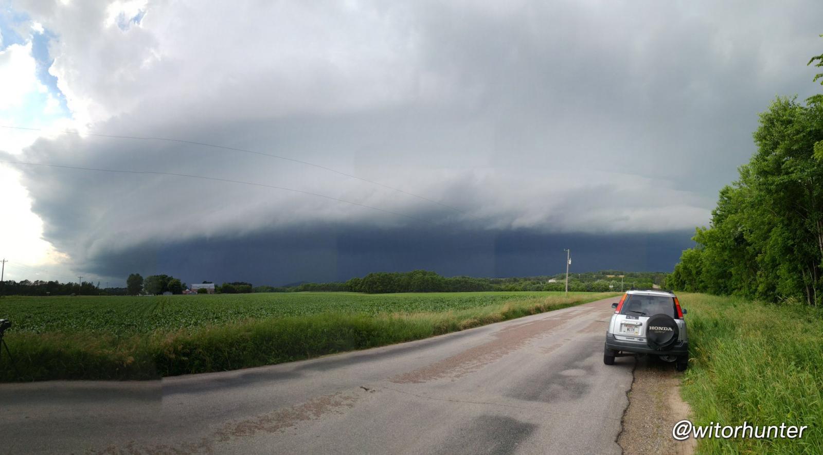
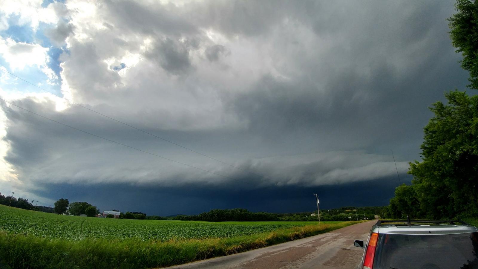
Shelf cloud approaching Lookout, WI (Buffalo Co.) (Photo by Hunter Anderson) |
Shelf cloud approaching Lookout, WI (Buffalo Co.) (Photo by Hunter Anderson) |
 |
 |
 |
 |
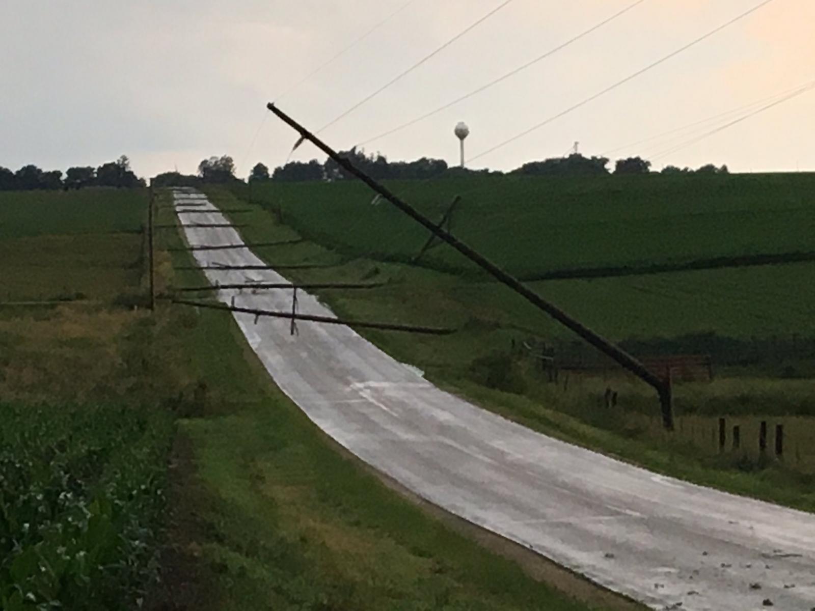
| Power lines blown down near Livingston, WI (Photo used with permission by Chris Gothner) |
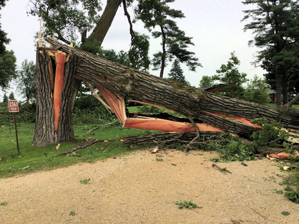
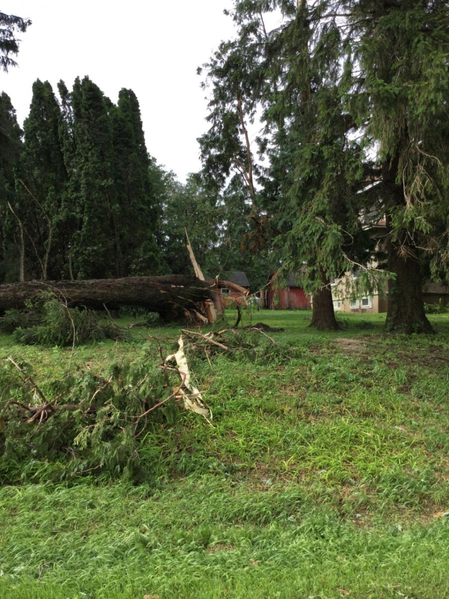
Damage near Livingston, WI | Damage near Livingston, WI | Damage near Livingston, WI |
 |
 |
 |
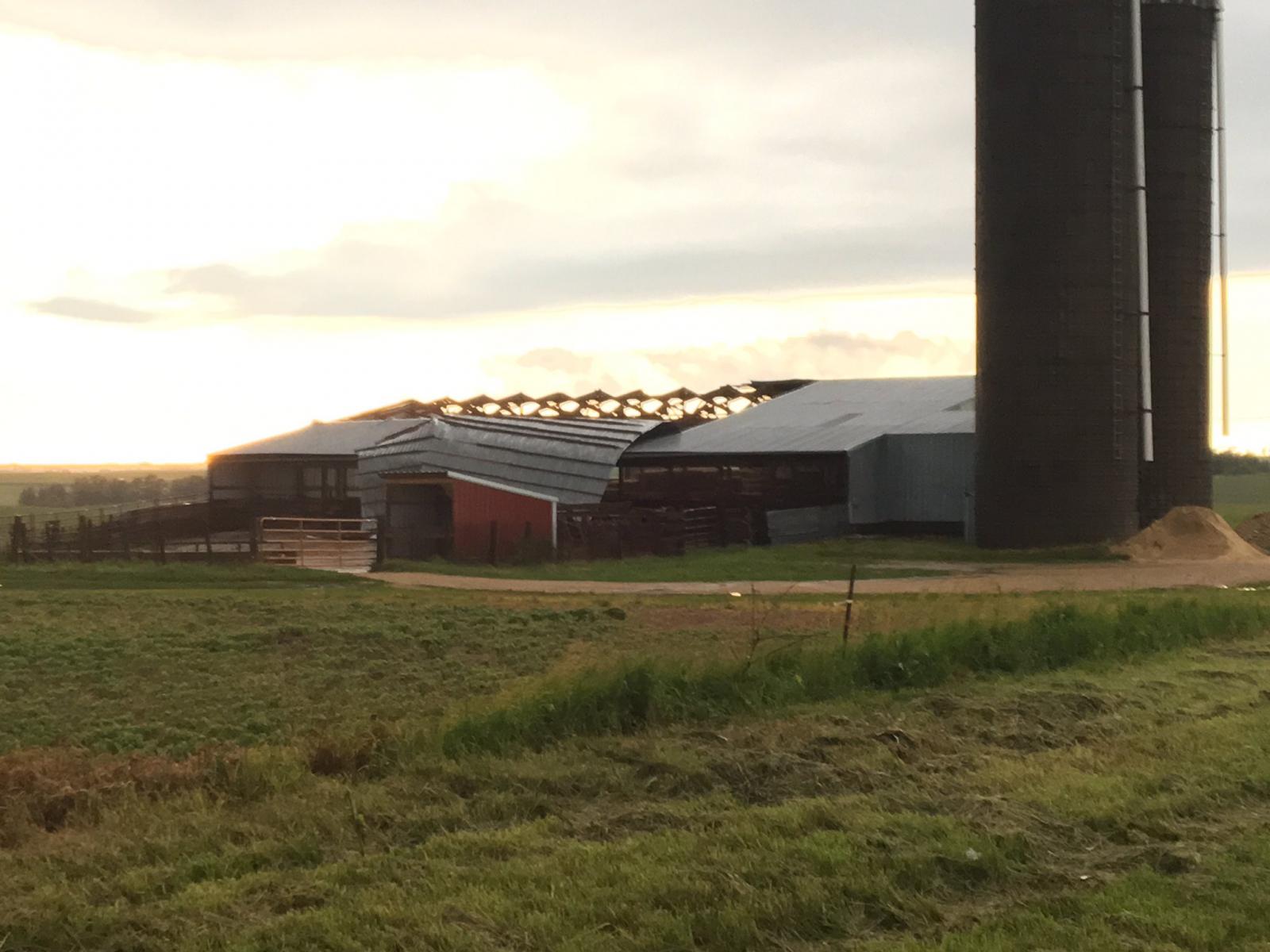 |
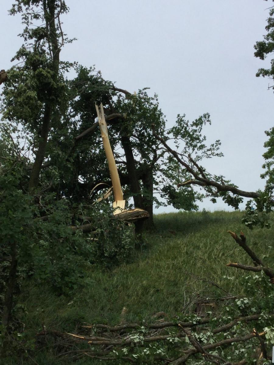
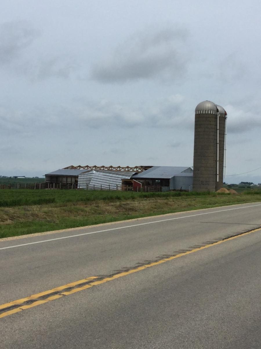
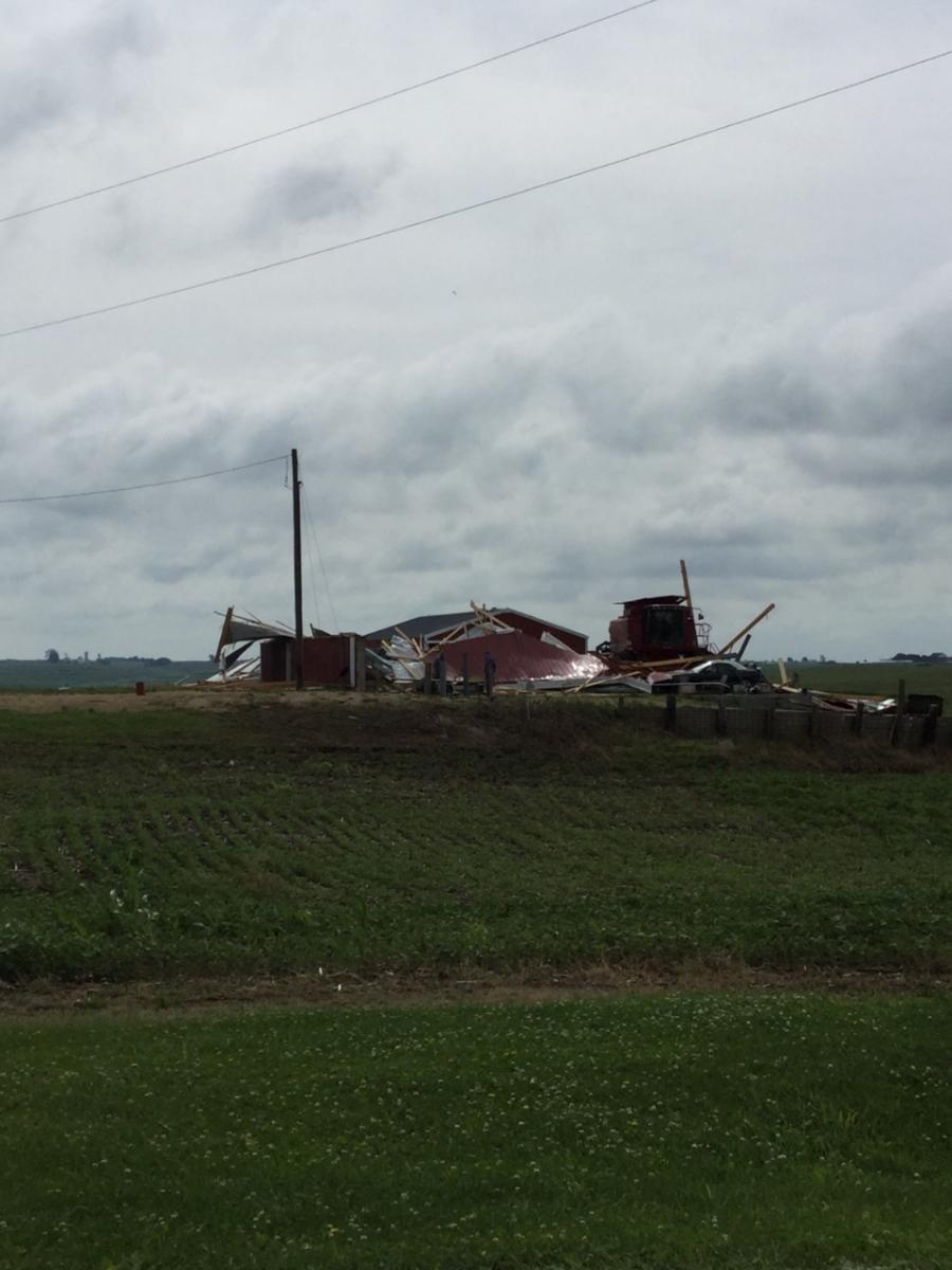
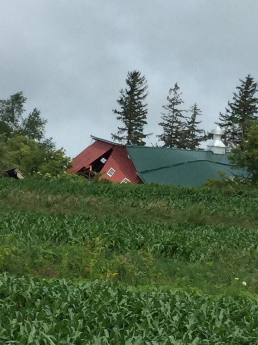
| Damage near Farmersburg, IA | Damage near Farmersburg, IA | Damage near Farmersburg, IA | Barn damage in Grant County, WI (Photo used with permission by Chris Gothner) |
Radar:
 |
 |
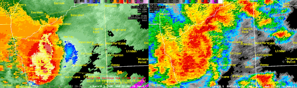 |
| Radar rainfall estimations radar - ending 1030 p.m. June 28th | Storm-relative Velocity (left) and Reflectivity loop (right) for the Viola, MN tornado time | Storm-relative Velocity (left) and Reflectivity loop (right) for the Grant Co. WI 70-90 mph winds. |
Storm Reports
PRELIMINARY LOCAL STORM REPORT...SUMMARY
NATIONAL WEATHER SERVICE LA CROSSE WI
955 PM CDT WED JUN 28 2017

..TIME...   ...EVENT...      ...CITY LOCATION...     ...LAT.LON...
..DATE...   ....MAG....      ..COUNTY LOCATION..ST.. ...SOURCE....
            ..REMARKS..

0320 PM     HAIL             MARBLE ROCK             42.96N 92.87W
06/28/2017  M0.75 INCH       FLOYD              IA   FIRE DEPT/RESCUE


0343 PM     HAIL             NEW HAMPTON             43.06N 92.31W
06/28/2017  E0.25 INCH       CHICKASAW          IA   PUBLIC


0345 PM     HAIL             NEW HAMPTON             43.06N 92.31W
06/28/2017  M0.75 INCH       CHICKASAW          IA   EMERGENCY MNGR


0359 PM     HAIL             3 NNE BOYD              43.06N 92.24W
06/28/2017  E0.75 INCH       CHICKASAW          IA   PUBLIC

            NEAR 205TH AND HIGHWAY 18.


0403 PM     TSTM WND DMG     CALMAR                  43.18N 91.86W
06/28/2017                   WINNESHIEK         IA   PUBLIC

            TREE SNAPPED. RELAYED VIA BROADCAST MEDIA.
            TIME ESTIMATED FROM RADAR.


0453 PM     TSTM WND DMG     2 NNW FARMERSBURG       42.98N 91.39W
06/28/2017                   CLAYTON            IA   EMERGENCY MNGR

            NUMEROUS TREES DOWN AT INTERSECTION OF 165TH
            STREET AND FALCON AVE. TIME ESTIMATED FROM
            RADAR.


0505 PM     TSTM WND GST     1 E FARMERSBURG         42.96N 91.35W
06/28/2017  M60 MPH          CLAYTON            IA   EMERGENCY MNGR

            PEA SIZE HAIL ALSO.


0520 PM     HEAVY RAIN       3 SSE STEUBEN           43.13N 90.84W
06/28/2017  M2.00 INCH       CRAWFORD           WI   CO-OP OBSERVER


0523 PM     TSTM WND DMG     4 SSE GIARD             42.96N 91.25W
06/28/2017                   CLAYTON            IA   EMERGENCY MNGR

            POWER LINES DOWN. 20-24 INCH TREE DOWN.


0537 PM     TSTM WND GST     CASSVILLE               42.72N 90.99W
06/28/2017  E60 MPH          GRANT              WI   FIRE DEPT/RESCUE

            REPORT RELAYED BY THE EMERGENCY MANAGER.


0545 PM     TSTM WND GST     1 N LANCASTER           42.86N 90.71W
06/28/2017  M58 MPH          GRANT              WI   TRAINED SPOTTER


0554 PM     TSTM WND GST     3 NE LANCASTER          42.88N 90.67W
06/28/2017  M63 MPH          GRANT              WI   TRAINED SPOTTER

            ON COUNTY RD A.


0600 PM     TSTM WND DMG     1 W LIVINGSTON          42.90N 90.45W
06/28/2017                   GRANT              WI   PUBLIC

            ROOF BLOWN OFF BARN. VIA SOCIAL MEDIA. TIME
            ESTIMATED FROM RADAR.


0602 PM     TSTM WND DMG     LIVINGSTON              42.90N 90.43W
06/28/2017                   GRANT              WI   PUBLIC

            NUMEROUS POWER POLES DOWN ON COUNTY ROAD E.
            TIME ESTIMATED FROM RADAR.

0602 PM     TSTM WND DMG     2 N LIVINGSTON          42.93N 90.43W
06/28/2017                   GRANT              WI   PUBLIC

            DAMAGE TO FARM OUTBUILDINGS. RELAYED VIA
            BROADCAST MEDIA/SOCIAL MEDIA. TIME ESTIMATED
            FROM RADAR.

0603 PM     TSTM WND GST     3 NW LIVINGSTON         42.93N 90.47W
06/28/2017  M78 MPH          GRANT              WI   FIRE DEPT/RESCUE


0603 PM     TSTM WND GST     MONTFORT                42.97N 90.43W
06/28/2017  E80 MPH          GRANT              WI   FIRE DEPT/RESCUE


0621 PM     HEAVY RAIN       WEST UNION              42.96N 91.81W
06/28/2017  M4.75 INCH       FAYETTE            IA   PUBLIC

            RELAYED VIA SOCIAL MEDIA.


0625 PM     TORNADO          2 NNE DOVER             44.00N 92.12W
06/28/2017                   OLMSTED            MN   LAW ENFORCEMENT

            BRIEF TOUCHDOWN REPORTED FROM ST CHARLES
            LOOKING NORTHWEST.

0709 PM     TORNADO          CHESTER                 44.00N 92.31W
06/28/2017                   OLMSTED            MN   PUBLIC

            POSSIBLE BRIEF TOUCHDOWN WITH TREE DAMAGE.

0717 PM     FLASH FLOOD      3 S RANDALIA            42.82N 91.88W
06/28/2017                   FAYETTE            IA   PUBLIC

            LITTLE VOLGA RIVER FLOWING OVER 130TH ST.

0717 PM     FLASH FLOOD      3 N MAYNARD             42.82N 91.88W
06/28/2017                   FAYETTE            IA   PUBLIC

            LITTLE VOLGA RIVER FLOWING OVER 130TH ST.

0745 PM     TSTM WND DMG     4 SSE ROCHESTER         43.96N 92.46W
06/28/2017                   OLMSTED            MN   PUBLIC

            POWER POLE SNAPPED. RELAYED VIA BROADCAST
            MEDIA. TIME ESTIMATED FROM RADAR.

0910 PM     HEAVY RAIN       PLATTEVILLE             42.74N 90.48W
06/28/2017  M2.70 INCH       GRANT              WI   AMATEUR RADIO
Rain Reports
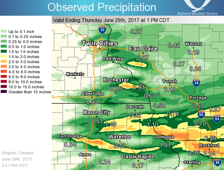
(Click to enlarge map)
Public Information Statement
National Weather Service La Crosse WI
834 AM CDT Thu Jun 29 2017

...Rainfall Reports...

Location                     Amount    Time/Date       Lat/Lon

...Iowa...

...Allamakee County...
3 WNW Elon                   2.20 in   0828 AM 06/29   43.27N/91.38W
4 ENE Watson                 1.10 in   0745 AM 06/29   43.11N/91.26W
3 S Dorchester               0.49 in   0800 AM 06/29   43.42N/91.51W

...Chickasaw County...
New Hampton                  2.30 in   0700 AM 06/29   43.06N/92.31W
New Hampton                  2.14 in   0700 AM 06/29   43.06N/92.32W
Ionia 2W                     2.01 in   0745 AM 06/29   43.03N/92.50W
Fredericksburg               1.64 in   0827 AM 06/29   42.97N/92.20W

...Clayton County...
Guttenberg Dam 10            2.75 in   0600 AM 06/29   42.78N/91.10W
Garber                       2.72 in   0715 AM 06/29   42.74N/91.26W
Littleport                   2.20 in   0745 AM 06/29   42.75N/91.37W
Volga 1NE                    2.06 in   0600 AM 06/29   42.81N/91.52W
Elkader 5NW                  1.78 in   0800 AM 06/29   42.91N/91.47W
Edgewood                     1.50 in   0530 AM 06/29   42.65N/91.40W
Monona WWTP                  1.46 in   0700 AM 06/29   43.04N/91.40W
Marquette-Bloody Run Creek   0.33 in   0800 AM 06/29   43.04N/91.21W
Elkader Turkey River         0.04 in   0745 AM 06/29   42.84N/91.40W

...Fayette County...
Fayette                      2.16 in   0700 AM 06/29   42.85N/91.82W
Fayette-CWOP                 1.82 in   0816 AM 06/29   42.84N/91.80W
1 ENE Alpha                  1.43 in   0700 AM 06/29   43.01N/92.03W
Eldorado                     1.13 in   0745 AM 06/29   43.05N/91.81W
Waucoma 1WNW                 1.13 in   0700 AM 06/29   43.06N/92.05W
Oelwein Municipal Airport    0.03 in   0655 AM 06/29   42.68N/91.97W

...Floyd County...
Charles City-Cedar River     1.65 in   0730 AM 06/29   43.06N/92.67W
Charles City                 1.41 in   0700 AM 06/29   43.06N/92.67W
Charles City Airport         1.33 in   0655 AM 06/29   43.07N/92.61W
Nashua 2sw                   1.28 in   0700 AM 06/29   42.94N/92.57W
Rockford-Shell Rock Rvr      0.90 in   0745 AM 06/29   43.01N/92.93W
Nora Springs 2.4 SSE         0.55 in   0700 AM 06/29   43.11N/92.99W

...Howard County...
Elma                         0.68 in   0700 AM 06/29   43.24N/92.44W
3 NE Riceville               0.53 in   0812 AM 06/29   43.40N/92.50W
Cresco 1NE                   0.51 in   0700 AM 06/29   43.39N/92.09W

...Mitchell County...
St Ansgar                    0.62 in   0630 AM 06/29   43.38N/92.92W
Saint Ansgar                 0.50 in   0815 AM 06/29   43.38N/92.92W
Osage                        0.40 in   0700 AM 06/29   43.28N/92.81W
Osage                        0.36 in   0745 AM 06/29   43.28N/92.85W

...Winneshiek County...
Decorah Municipal Airport    0.30 in   0655 AM 06/29   43.28N/91.74W

...Minnesota...

...Dodge County...
Hayfield                     0.82 in   0630 AM 06/29   43.89N/92.85W
2 NE Kasson                  0.24 in   0600 AM 06/29   44.05N/92.72W
2 E Claremont                0.09 in   0800 AM 06/29   44.04N/92.95W

...Fillmore County...
Lanesboro-Root River         1.53 in   0730 AM 06/29   43.72N/91.98W
1 SSE Pilot Mound            1.49 in   0700 AM 06/29   43.79N/92.03W
Lanesboro 2NE                1.32 in   0730 AM 06/29   43.73N/91.94W
Pilot Mound-Root River       1.14 in   0800 AM 06/29   43.78N/92.03W
Spring Valley                0.80 in   0700 AM 06/29   43.69N/92.39W
Preston Airport              0.76 in   0652 AM 06/29   43.68N/92.18W
Fillmore                     0.73 in   0730 AM 06/29   43.76N/92.27W
1 W Fillmore                 0.70 in   0700 AM 06/29   43.74N/92.31W
Mabel                        0.45 in   0630 AM 06/29   43.52N/91.76W

...Houston County...
Caledonia                    1.28 in   0700 AM 06/29   43.63N/91.50W
Mound Prairie                1.22 in   0745 AM 06/29   43.78N/91.45W
Houston                      0.05 in   0745 AM 06/29   43.77N/91.57W
4 SSE Mound Prairie          0.01 in   0815 AM 06/29   43.72N/91.44W

...Mower County...
Ostrander 5.1 WNW            0.88 in   0700 AM 06/29   43.65N/92.52W
Austin 3 NW - Turtle Creek   0.45 in   0730 AM 06/29   43.65N/92.98W
Austin 3S                    0.43 in   0800 AM 06/29   43.64N/92.97W
Grand Meadow                 0.40 in   0500 AM 06/29   43.71N/92.56W
Austin Municipal Airport     0.30 in   0655 AM 06/29   43.66N/92.93W
Austin 2NE-Dobbins Creek     0.23 in   0730 AM 06/29   43.67N/92.95W

...Olmsted County...
Dover                        2.90 in   0800 AM 06/29   43.97N/92.12W
Eyota 2NE                    2.38 in   0730 AM 06/29   44.01N/92.20W
Elgin 5SE                    2.10 in   0730 AM 06/29   44.01N/92.11W
Elgin 2ssw                   1.80 in   0700 AM 06/29   44.10N/92.27W
4 WSW Rochester              1.46 in   0800 AM 06/29   43.98N/92.56W
1 W Chester                  1.30 in   0623 AM 06/29   44.00N/92.38W
2 NE Rochester               0.86 in   0600 AM 06/29   44.04N/92.44W
2 ENE Rochester              0.78 in   0730 AM 06/29   44.03N/92.43W
Rochester-Beltline Bear Cree 0.78 in   0730 AM 06/29   44.01N/92.45W
Rochester-Cascade Creek      0.72 in   0730 AM 06/29   44.03N/92.47W
Mayo Helipad                 0.66 in   0652 AM 06/29   44.02N/92.48W
2 NNW Rochester              0.63 in   0700 AM 06/29   44.05N/92.49W
2 NE Rochester               0.62 in   0825 AM 06/29   44.04N/92.45W
Rochester                    0.61 in   0819 AM 06/29   44.01N/92.49W
2 W High Forest              0.59 in   0500 AM 06/29   43.85N/92.59W
Rochester 3W                 0.52 in   0730 AM 06/29   44.02N/92.53W
Rochester Ap 2ne             0.52 in   0700 AM 06/29   43.93N/92.48W
2 NE Rochester               0.52 in   0825 AM 06/29   44.04N/92.44W
Oronoco                      0.38 in   0730 AM 06/29   44.16N/92.54W
Rochester-Beltline           0.36 in   0730 AM 06/29   44.01N/92.47W
Byron                        0.34 in   0812 AM 06/29   44.04N/92.64W
Rochester International Airp 0.31 in   0654 AM 06/29   43.91N/92.50W
Oronoco 1W                   0.28 in   0730 AM 06/29   44.17N/92.55W
Byron                        0.25 in   0821 AM 06/29   44.03N/92.66W
4 ESE Douglas                0.18 in   0822 AM 06/29   44.09N/92.49W
3 ESE Douglas                0.16 in   0820 AM 06/29   44.09N/92.51W
Byron 4 North                0.14 in   0700 AM 06/29   44.09N/92.64W
2 SE Douglas                 0.11 in   0817 AM 06/29   44.08N/92.55W
Pine Island 1S               0.10 in   0800 AM 06/29   44.19N/92.65W
3 SW Hammond                 0.08 in   0810 AM 06/29   44.18N/92.41W
2 SE Eyota                   0.01 in   0815 AM 06/29   43.96N/92.21W

...Wabasha County...
Plainview                    0.75 in   0824 AM 06/29   44.17N/92.17W
Wabasha                      0.26 in   0700 AM 06/29   44.38N/92.05W
Mazeppa 3ESE                 0.18 in   0730 AM 06/29   44.26N/92.49W
Kellogg-Zumbro River         0.13 in   0800 AM 06/29   44.32N/92.00W
Theilman 1SSW                0.11 in   0800 AM 06/29   44.28N/92.19W
2 NNW Zumbro Falls           0.08 in   0816 AM 06/29   44.32N/92.44W
Lake City                    0.08 in   0625 AM 06/29   44.44N/92.28W

...Winona County...
3 ESE Stockton               2.85 in   0826 AM 06/29   44.01N/91.71W
Lewiston                     2.38 in   0700 AM 06/29   43.99N/91.87W
Minnesota City Dam 5         1.90 in   0700 AM 06/29   44.16N/91.81W
Whitewater State Park Group  1.75 in   0730 AM 06/29   44.06N/92.05W
Stockton                     1.70 in   0713 AM 06/29   44.03N/91.77W
Altura 5w                    1.58 in   0700 AM 06/29   44.06N/92.04W
Elba                         1.47 in   0745 AM 06/29   44.09N/92.03W
Whitewater State Park        1.45 in   0730 AM 06/29   44.05N/92.05W
Dakota                       1.42 in   0815 AM 06/29   43.91N/91.36W
2 NNW Pickwick               1.22 in   0700 AM 06/29   44.02N/91.61W
La Crescent Dam 7            1.14 in   0600 AM 06/29   43.87N/91.31W
Beaver-White Water River     1.01 in   0745 AM 06/29   44.15N/92.00W
1 ESE Minnesota City         0.55 in   0700 AM 06/29   44.08N/91.73W
Winona Municipal Airport     0.53 in   0653 AM 06/29   44.08N/91.71W
1 E Ridgeway                 0.01 in   0815 AM 06/29   43.91N/91.54W

...Wisconsin...

...Buffalo County...
5 NE Montana                 0.92 in   0700 AM 06/29   44.40N/91.60W
Alma Dam 4                   0.32 in   0600 AM 06/29   44.33N/91.92W

...Clark County...
Colby 6SW                    1.00 in   0918 PM 06/28   44.87N/90.42W
Neillsville 1W               0.75 in   0700 AM 06/29   44.56N/90.61W

...Crawford County...
Steuben                      2.26 in   0745 AM 06/29   43.18N/90.86W
Steuben 4SE                  2.22 in   0600 AM 06/29   43.13N/90.84W
Lynxville Dam 9              1.87 in   0600 AM 06/29   43.21N/91.10W
Prairie Du Chien  Airport    1.42 in   0655 AM 06/29   43.02N/91.12W
1 WNW Mount Zion             1.30 in   0700 AM 06/29   43.26N/90.76W
Prairie Du Chien             1.26 in   0700 AM 06/29   43.05N/91.13W
De Soto 1SE                  0.56 in   0700 AM 06/29   43.42N/91.19W
De Soto                      0.48 in   0821 AM 06/29   43.42N/91.19W

...Grant County...
Cuba City                    3.23 in   0800 AM 06/29   42.60N/90.43W
Platteville                  2.42 in   0700 AM 06/29   42.74N/90.47W
Lancaster                    2.29 in   0726 AM 06/29   42.85N/90.71W
Boscobel Airport             1.95 in   0653 AM 06/29   43.16N/90.67W
Muscoda                      1.94 in   0745 AM 06/29   43.20N/90.44W
Lancaster 4wsw               1.83 in   0800 AM 06/29   42.83N/90.79W
1 ENE Boscobel               1.37 in   0803 AM 06/29   43.15N/90.68W
Platteville Municipal Airpor 1.10 in   0655 AM 06/29   42.69N/90.44W

...Jackson County...
Black River Falls Sewage     0.70 in   0830 AM 06/29   44.29N/90.85W
Black River Falls Area Airpo 0.37 in   0655 AM 06/29   44.25N/90.86W
1 E Black River Falls        0.33 in   0815 AM 06/29   44.30N/90.83W

...Juneau County...
Mauston                      0.86 in   0822 AM 06/29   43.80N/90.07W
2 W Dellwood                 0.64 in   0630 AM 06/29   43.99N/89.99W
2 WNW Wisconsin Dells        0.52 in   0820 AM 06/29   43.65N/89.82W
Necedah                      0.52 in   0748 AM 06/29   44.03N/90.08W
Necedah 5 WNW                0.39 in   1200 AM 06/29   44.06N/90.17W
2 N Cloverdale               0.39 in   0810 AM 06/29   44.06N/90.17W

...La Crosse County...
3 W Saint Joseph             1.48 in   0815 AM 06/29   43.78N/91.10W
La Crosse Weather Office     1.35 in   0600 AM 06/29   43.82N/91.19W
Onalaska 2N                  1.31 in   0700 AM 06/29   43.91N/91.23W
West Salem 2W                1.00 in   0700 AM 06/29   43.90N/91.12W
La Crosse Regional Airport   0.97 in   0653 AM 06/29   43.88N/91.26W
1 SW West Salem              0.66 in   0700 AM 06/29   43.88N/91.10W

...Monroe County...
Sparta                       1.10 in   0800 AM 06/29   43.94N/90.82W
3 WNW Kendall                1.05 in   0700 AM 06/29   43.81N/90.44W
Kendall 1 North              0.97 in   0400 AM 06/29   43.81N/90.37W
Cashton 3NNW                 0.92 in   0757 AM 06/29   43.79N/90.80W
Sparta/Fort McCoy Airport    0.49 in   0655 AM 06/29   43.96N/90.74W
Warrens 4WSW                 0.39 in   0700 AM 06/29   44.10N/90.59W
Cataract                     0.34 in   0700 AM 06/29   44.08N/90.85W
Four Corners                 0.29 in   0700 AM 06/29   44.09N/90.91W
2 E Cataract                 0.26 in   0823 AM 06/29   44.09N/90.79W

...Richland County...
Richland Center 4N           0.67 in   0700 AM 06/29   43.40N/90.39W

...Taylor County...
Medford                      0.49 in   0800 AM 06/29   45.13N/90.34W
3 NE Lublin                  0.36 in   0814 AM 06/29   45.11N/90.69W
Medford Airport              0.30 in   0655 AM 06/29   45.10N/90.30W
Westboro 4E                  0.28 in   0700 AM 06/29   45.35N/90.22W
Chelsea                      0.26 in   0820 AM 06/29   45.30N/90.30W

...Trempealeau County...
1 NE Galesville              1.23 in   0600 AM 06/29   44.10N/91.34W
Trempealeau Dam 6            1.05 in   0600 AM 06/29   44.00N/91.44W
Osseo                        0.82 in   0700 AM 06/29   44.58N/91.22W
Ettrick 4WNW                 0.71 in   0648 AM 06/29   44.19N/91.34W
1 NW Trempealeau             0.48 in   0630 AM 06/29   44.03N/91.46W

...Vernon County...
Stoddard                     1.69 in   0700 AM 06/29   43.66N/91.22W
Viroqua                      1.20 in   0700 AM 06/29   43.56N/90.90W
Westby 3ENE                  1.12 in   0700 AM 06/29   43.67N/90.81W
Viroqua Municipal Airport    1.10 in   0655 AM 06/29   43.58N/90.90W
Viroqua 0.8 ESE              1.10 in   0700 AM 06/29   43.55N/90.87W
Viroqua                      1.06 in   0700 AM 06/29   43.56N/90.88W
Genoa Dam 8                  1.05 in   0600 AM 06/29   43.57N/91.23W
Hillsboro 2sw                0.88 in   0700 AM 06/29   43.63N/90.38W
La Farge                     0.88 in   0700 AM 06/29   43.57N/90.64W
3 WNW Viola                  0.72 in   0800 AM 06/29   43.53N/90.74W
Hillsboro WSW                0.71 in   0700 AM 06/29   43.65N/90.35W
Ontario                      0.70 in   0700 AM 06/29   43.72N/90.59W
Readstown                    0.69 in   0800 AM 06/29   43.45N/90.76W

Observations are collected from a variety of sources with varying
equipment and exposures. We thank all volunteer weather observers
for their dedication. Not all data listed are considered official.

$$
 |
Media use of NWS Web News Stories is encouraged! Please acknowledge the NWS as the source of any news information accessed from this site. |
|


 Weather Story
 Weather Map
 Local Radar