Overview
|
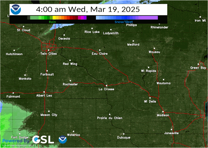
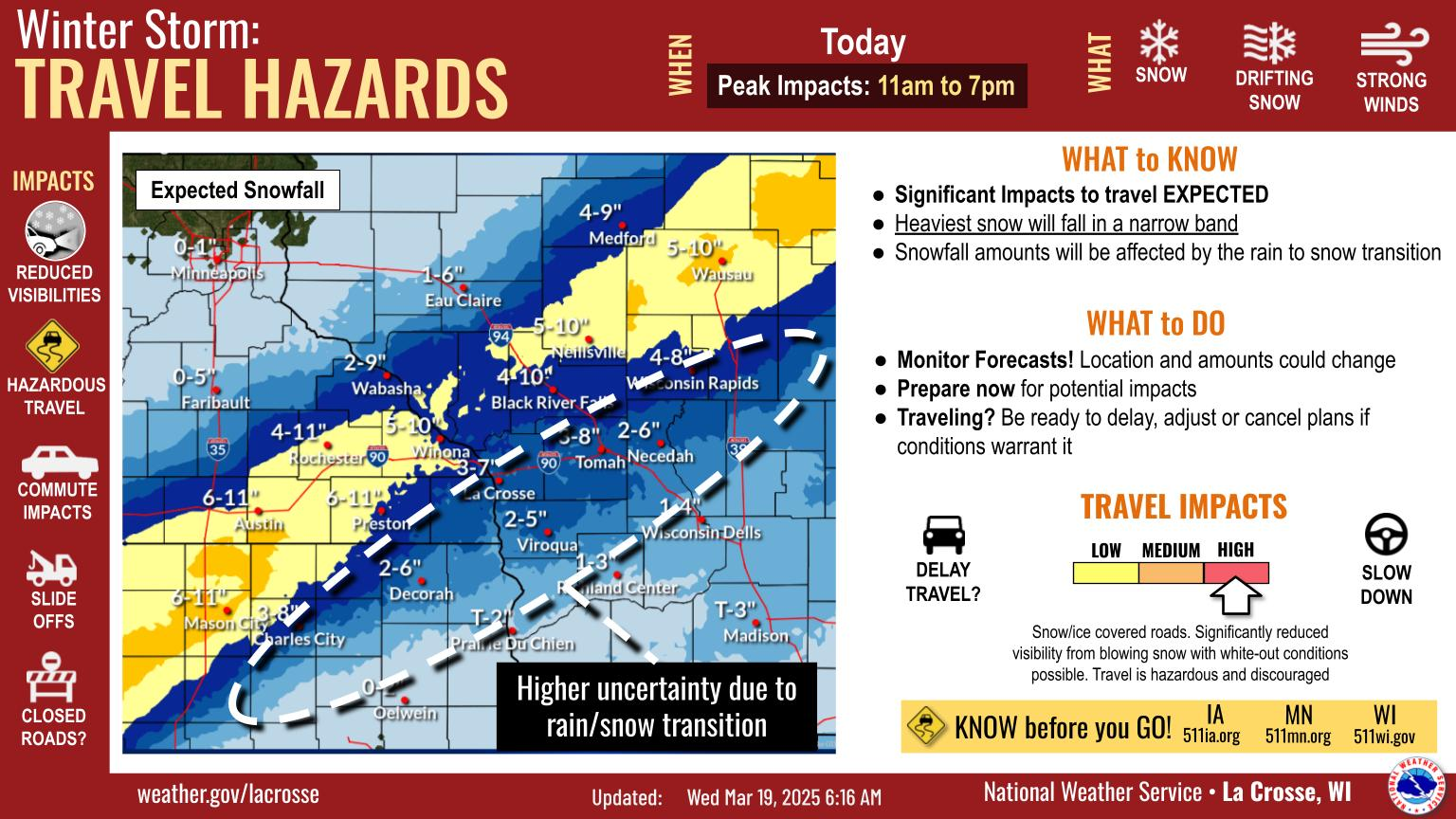
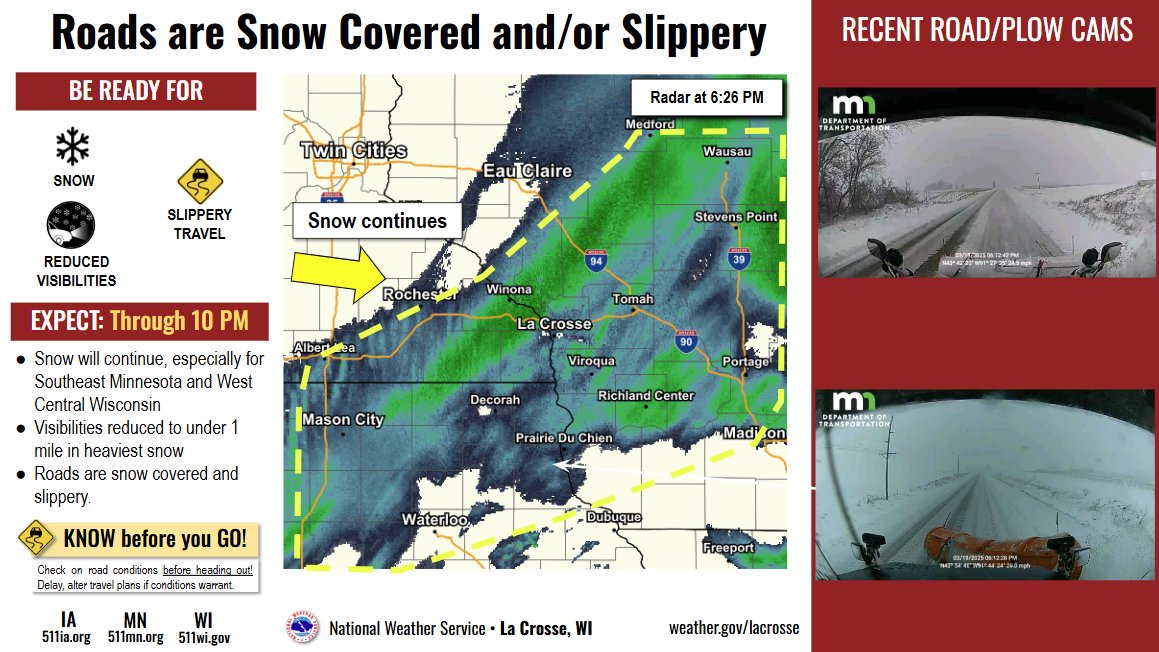
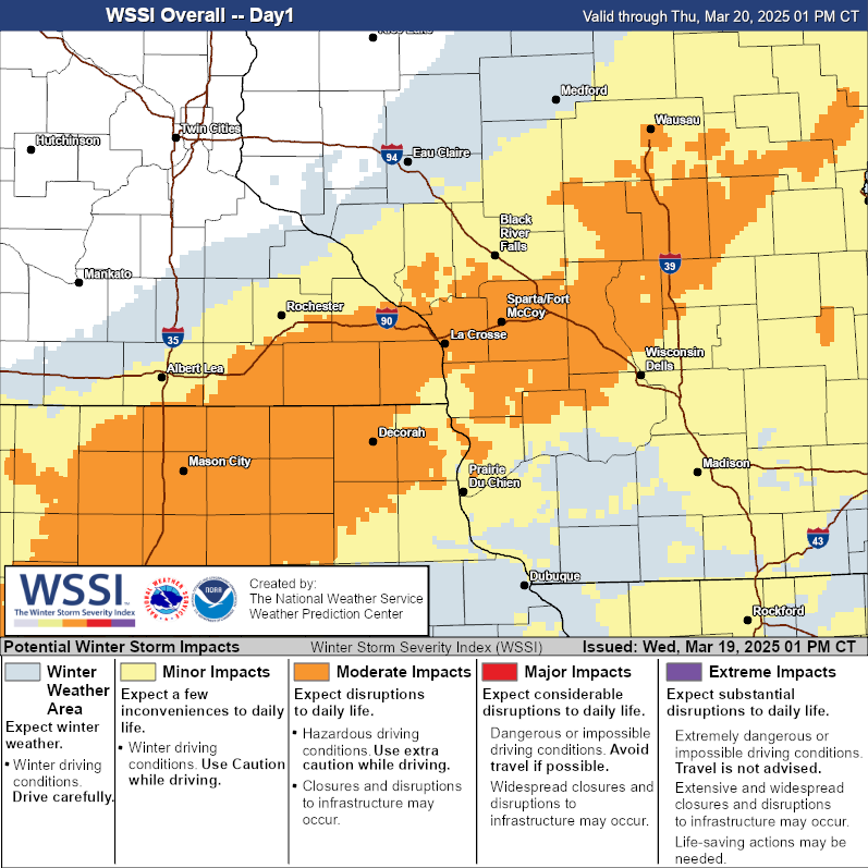
A strong spring low pressure system brought a narrow band of heavy, wet snow from north central Iowa and south central Minnesota northeast to central Wisconsin. Strong winds as high as 59 mph also occurred, with whiteout conditions occuring at times west of the Mississippi River. Snowfall totals generally ranged from 2 to 10 inches. |
 Event Radar |
Wind:
...HIGHEST WIND REPORTS FROM WEDNESDAY MARCH 19TH EVENT...

Location                     Speed     Time/Date       Lat/Lon
3 ESE Decorah                59 MPH    0355 PM 03/19   43.28N/91.73W
Decorah Municipal Airport    59 MPH    0355 PM 03/19   43.27N/91.72W
Lancaster                    54 MPH    0241 PM 03/19   42.83N/90.69W
Preston Airport              53 MPH    0215 PM 03/19   43.68N/92.17W
Saratoga                     51 MPH    1110 AM 03/19   43.37N/92.47W
U.s.218 - Lyle - Mp 4        51 MPH    1020 AM 03/19   43.56N/92.95W
U.s.14 - Byron - Mp 200      50 MPH    1100 AM 03/19   44.02N/92.71W
Charles City Airport         48 MPH    1035 AM 03/19   43.07N/92.62W
Rochester International Airp 47 MPH    0851 AM 03/19   43.90N/92.50W
Oelwein Municipal Airport    47 MPH    0355 PM 03/19   42.68N/91.97W
Greene                       47 MPH    0430 PM 03/19   42.93N/92.81W
Riceville                    46 MPH    1100 AM 03/19   43.36N/92.48W
New Hampton                  45 MPH    0430 PM 03/19   43.07N/92.46W
U.s.63 - Lake City - Mp 62.9 45 MPH    0335 PM 03/19   44.38N/92.37W
U.s.63 - Le Roy - Mp 0.5     44 MPH    1145 AM 03/19   43.51N/92.37W
New Hampton                  42 MPH    0857 AM 03/19   43.05N/92.30W
Platteville Municipal Airpor 41 MPH    0915 PM 03/19   42.68N/90.43W
Hawkeye                      41 MPH    1035 AM 03/19   42.96N/91.95W
T.h.52 - Canton - Mp 2       40 MPH    1025 AM 03/19   43.52N/91.89W
I-90 - Dexter - Mp 195       40 MPH    1105 AM 03/19   43.73N/92.68W
Saratoga                     40 MPH    0845 AM 03/19   43.35N/92.42W
U.s.63 - Stewartville - Mp 3 39 MPH    1200 PM 03/19   43.90N/92.48W
I-90 Eb At Ush 53 Nb         38 MPH    0131 PM 03/19   43.86N/91.24W
I-90 - Ridgeway - Mp 261     38 MPH    1130 AM 03/19   43.91N/91.54W
Viroqua Municipal Airport    38 MPH    1135 AM 03/19   43.58N/90.90W
La Crosse Regional Airport   38 MPH    0350 PM 03/19   43.88N/91.25W
I-90 - Eyota - Mp 226        37 MPH    1150 AM 03/19   43.96N/92.21W
Soldiers Grove               36 MPH    0515 PM 03/19   43.38N/90.90W
Decorah                      36 MPH    0535 PM 03/19   43.25N/91.70W
Volk Field                   36 MPH    0547 PM 03/19   43.93N/90.27W
Austin Municipal Airport     36 MPH    0735 AM 03/19   43.67N/92.92W
Platteville                  36 MPH    0335 PM 03/19   42.74N/90.46W
Dodge Center Airport         35 MPH    0235 PM 03/19   44.02N/92.82W
Boscobel Airport             35 MPH    1121 PM 03/19   43.15N/90.68W
Mayo Helipad                 35 MPH    0848 AM 03/19   44.02N/92.48W
Hayfield                     35 MPH    0817 AM 03/19   43.89N/92.85W
Nora Springs                 35 MPH    0915 AM 03/19   43.20N/93.02W
Osage                        35 MPH    0955 AM 03/19   43.26N/92.89W
Lyle                         35 MPH    0715 AM 03/19   43.51N/92.94W
Montana                      33 MPH    1230 PM 03/19   44.40N/91.56W
I-90 - La Crescent - Mp 276. 33 MPH    0820 AM 03/19   43.86N/91.30W
U.s.63 - Lake City - Mp 62.9 33 MPH    1240 PM 03/19   44.38N/92.37W
Medford                      33 MPH    0315 PM 03/19   45.30N/90.30W
Steuben                      33 MPH    0535 PM 03/19   43.21N/91.00W
Lancaster                    32 MPH    0720 PM 03/19   42.83N/90.79W
Greenwood                    32 MPH    1230 PM 03/19   44.72N/90.60W
La Crosse                    32 MPH    1208 PM 03/19   43.82N/91.19W
Medford Airport              32 MPH    0415 PM 03/19   45.10N/90.30W
Warrens                      31 MPH    0110 PM 03/19   44.12N/90.41W
Prairie Du Chien  Airport    31 MPH    1035 AM 03/19   43.02N/91.12W
Onalaska                     31 MPH    1214 PM 03/19   43.89N/91.18W
Rudd                         31 MPH    0935 AM 03/19   43.18N/92.83W
Calmar                       31 MPH    1055 AM 03/19   43.25N/91.82W
Boscobel                     31 MPH    0103 PM 03/19   43.15N/90.68W
U.s.61 - Kellogg - Mp 53     30 MPH    1255 PM 03/19   44.28N/91.99W
Necedah                      29 MPH    0148 PM 03/19   44.03N/90.08W
T.h.44 - Hokah - Mp 60       29 MPH    0650 PM 03/19   43.72N/91.44W
AUSTIN                       29 MPH    0733 AM 03/19   43.65N/93.00W
Westboro                     29 MPH    0500 PM 03/19   45.37N/90.31W
Rochester                    29 MPH    1130 AM 03/19   44.18N/92.41W
1 E Black River Falls        29 MPH    0115 PM 03/19   44.30N/90.73W
Richland Center              28 MPH    0655 PM 03/19   43.37N/90.38W
Osseo                        28 MPH    0145 PM 03/19   44.59N/91.27W
Us18 Wb At Mississippi River 28 MPH    0940 PM 03/19   43.05N/91.15W
Crawford Co. Sth 27 Sb 0.25  28 MPH    0609 PM 03/19   43.31N/90.94W
Rochester                    28 MPH    0616 AM 03/19   44.04N/92.44W
Austin                       28 MPH    0210 PM 03/19   43.56N/93.02W
3 NE Lublin                  28 MPH    0114 PM 03/19   45.11N/90.69W
Rochester                    28 MPH    1110 AM 03/19   44.09N/92.51W
Black River Falls            27 MPH    0150 PM 03/19   44.19N/90.74W
ROCHESTER                    27 MPH    1122 AM 03/19   43.93N/92.47W
La Farge                     27 MPH    0100 PM 03/19   43.60N/90.63W
Lake City                    27 MPH    0630 PM 03/19   44.44N/92.28W
Byron                        27 MPH    0330 PM 03/19   44.03N/92.63W
2 NE Dougherty               27 MPH    0840 AM 03/19   42.95N/93.01W
Sparta/Fort McCoy Airport    26 MPH    0642 PM 03/19   43.97N/90.73W
St.Ansgar                    26 MPH    0955 AM 03/19   43.38N/92.92W
Saint Ansgar                 25 MPH    0205 PM 03/19   43.39N/92.98W
Cutler                       24 MPH    0125 PM 03/19   44.03N/90.26W
New Hampton                  24 MPH    0900 AM 03/19   43.06N/92.32W
Monona                       24 MPH    0639 PM 03/19   43.04N/91.39W
Winona Municipal Airport     24 MPH    0215 PM 03/19   44.07N/91.70W
Stacyville                   24 MPH    0747 AM 03/19   43.44N/92.78W
Hokah                        24 MPH    0200 PM 03/19   43.80N/91.43W
Trempealeau                  24 MPH    0834 AM 03/19   44.07N/91.51W
Osage                        24 MPH    0355 PM 03/19   43.25N/92.91W
La Farge                     23 MPH    1215 PM 03/19   43.60N/90.63W
Black River Falls Area Airpo 23 MPH    1235 PM 03/19   44.25N/90.85W
Lawler                       23 MPH    1105 AM 03/19   43.18N/92.18W
COLBY                        23 MPH    1234 PM 03/19   44.91N/90.32W
Mauston Airport              22 MPH    0835 AM 03/19   43.83N/90.13W
Gilman                       22 MPH    0955 PM 03/19   45.17N/90.82W
NEILLSVILLE                  21 MPH    0149 PM 03/19   44.61N/90.65W
STETSONVILLE                 21 MPH    0409 PM 03/19   45.04N/90.34W
Rochester                    21 MPH    0840 AM 03/19   44.05N/92.53W
Rochester                    21 MPH    0125 PM 03/19   44.09N/92.49W
1 ENE Jackson Junction       20 MPH    1200 PM 03/19   43.11N/92.04W
New Lisbon                   20 MPH    0945 AM 03/19   43.87N/90.17W
Fennimore                    20 MPH    0650 PM 03/19   42.98N/90.66W
Fort Atkinson                20 MPH    1115 AM 03/19   43.10N/91.50W
Austin                       20 MPH    0915 AM 03/19   43.63N/93.02W
Rochester                    20 MPH    0855 AM 03/19   44.07N/92.53W
Decorah                      20 MPH    1145 AM 03/19   43.30N/91.79W
Burns                        20 MPH    0107 PM 03/19   43.91N/90.97W
U.s.61 - Winona              19 MPH    0830 AM 03/19   43.98N/91.43W
Osage                        19 MPH    0935 AM 03/19   43.31N/92.84W
Altura                       19 MPH    0735 AM 03/19   44.20N/92.00W
2 ENE Marshland              19 MPH    0635 PM 03/19   44.09N/91.51W
Holmen                       18 MPH    0845 AM 03/19   43.96N/91.23W
Tomah                        18 MPH    0805 AM 03/19   43.99N/90.67W
Soldiers Grove               18 MPH    0115 PM 03/19   43.35N/90.60W
Uscrn Site Near Necedah 5wnw 17 MPH    1000 AM 03/19   44.06N/90.17W
Millston                     17 MPH    0135 PM 03/19   44.15N/90.69W
Monroe Co. I-94 Wb At Us 12  16 MPH    1230 PM 03/19   44.02N/90.50W
Mondovi                      16 MPH    0925 AM 03/19   44.48N/91.80W
La Crosse                    16 MPH    0545 PM 03/19   43.77N/91.22W
2 ENE Marshland              16 MPH    0240 PM 03/19   44.09N/91.51W
3 SE Waterville              15 MPH    1007 PM 03/19   43.17N/91.24W
Grand Marsh                  15 MPH    0145 PM 03/19   43.89N/89.68W
Bangor                       15 MPH    0830 AM 03/19   43.89N/90.99W
Rochester                    14 MPH    1140 AM 03/19   44.05N/92.40W
Charles City                 13 MPH    0952 AM 03/19   43.05N/92.67W
La Crescent 4.0 NNW          13 MPH    0645 AM 03/19   43.88N/91.34W
Plainview                    13 MPH    0135 PM 03/19   44.05N/91.65W
I-94 Eb 0.7 Mi Southeast Of  12 MPH    0129 PM 03/19   44.34N/90.91W
Lake City                    12 MPH    1155 AM 03/19   44.44N/92.27W
Mcgregor                     10 MPH    0844 AM 03/19   43.02N/91.19W

Observations are collected from a variety of sources with varying
equipment and exposures. We thank all volunteer weather observers
for their dedication. Not all data listed are considered official.
|
 Maximum Observed Wind Gusts |
Snow
...SNOWFALL REPORTS...

Location                     Amount    Time/Date       Lat/Lon

...Iowa...

...Allamakee County...
Waukon                       3.0 in    0545 PM 03/19   43.27N/91.48W
Monona 9.8 N                 3.0 in    0700 AM 03/20   43.19N/91.35W
Postville 5.5 NE             2.5 in    0700 AM 03/20   43.14N/91.49W

...Chickasaw County...
New Hampton                  2.0 in    0700 AM 03/20   43.06N/92.32W
New Hampton 0.4 SW           2.0 in    0700 AM 03/20   43.06N/92.32W
New Hampton                  2.0 in    0700 AM 03/20   43.06N/92.31W

...Clayton County...
Monona 0.2 WNW               3.3 in    0630 AM 03/20   43.05N/91.39W
Elkader 6.8 WSW              0.5 in    0630 AM 03/20   42.81N/91.52W

...Fayette County...
Oelwein 1 E                  1.2 in    0630 AM 03/20   42.68N/91.88W
3 N Fayette                  1.0 in    0444 PM 03/19   42.88N/91.83W
Fayette                      1.0 in    0700 AM 03/20   42.88N/91.83W
Waucoma 1 WNW                1.0 in    0700 AM 03/20   43.06N/92.05W

...Floyd County...
Marble Rock                  6.0 in    0700 PM 03/19   42.96N/92.87W
5 SSW Floyd                  6.0 in    0941 PM 03/19   43.07N/92.77W

...Howard County...
5 NE Mcintire                7.0 in    0903 PM 03/19   43.48N/92.51W

...Mitchell County...
St Ansgar                    4.6 in    0630 AM 03/20   43.38N/92.92W
Osage                        4.0 in    0705 AM 03/20   43.28N/92.81W
2 NNE Carpenter              2.5 in    0116 PM 03/19   43.44N/93.00W

...Winneshiek County...
7 ENE Decorah                2.5 in    0844 AM 03/20   43.34N/91.64W
8 NE Decorah                 2.0 in    0907 PM 03/19   43.39N/91.68W
Decorah                      1.0 in    0350 PM 03/19   43.30N/91.80W
Decorah                      1.0 in    0400 PM 03/19   43.30N/91.80W

...Minnesota...

...Dodge County...
Hayfield 0.3 SSE             3.7 in    0630 AM 03/20   43.89N/92.85W
Kasson 5.7 SE                3.5 in    0900 AM 03/20   43.96N/92.68W
Mantorville 1.9 ESE          3.0 in    0700 AM 03/20   44.05N/92.72W
Pine Island 5.3 WSW          1.0 in    0700 AM 03/20   44.18N/92.75W
Mantorville                  0.8 in    1256 PM 03/19   44.07N/92.76W

...Fillmore County...
Peterson                     9.1 in    0700 AM 03/20   43.79N/91.83W
Spring Valley                9.0 in    0818 PM 03/19   43.69N/92.39W
Chatfield                    8.5 in    0806 PM 03/19   43.84N/92.19W
2 WSW Fillmore               7.6 in    0700 PM 03/19   43.74N/92.31W
Wykoff 3.1 NW                7.6 in    0700 AM 03/20   43.74N/92.31W
Mabel                        7.0 in    0939 PM 03/19   43.52N/91.77W
3 W Fountain                 6.7 in    0847 PM 03/19   43.74N/92.19W
Chatfield 9.0 ESE            6.5 in    0700 AM 03/20   43.79N/92.03W
Lanesboro 0.2 SSW            5.2 in    0600 AM 03/20   43.72N/91.97W
3 WNW Spring Valley          2.0 in    0123 PM 03/19   43.71N/92.45W

...Houston County...
Caledonia                    10.0 in   0937 PM 03/19   43.63N/91.50W
1 ENE Mound Prairie          7.3 in    0615 AM 03/20   43.79N/91.42W
Hokah 4 NW                   7.3 in    0700 AM 03/20   43.80N/91.43W
1 W La Crescent              7.0 in    0756 PM 03/19   43.83N/91.33W
Spring Grove                 7.0 in    0700 AM 03/20   43.56N/91.64W
La Crescent                  6.8 in    1107 PM 03/19   43.83N/91.31W
Caledonia                    6.8 in    0600 AM 03/20   43.63N/91.50W
2 ENE Money Creek            4.5 in    0820 PM 03/19   43.83N/91.57W
Brownsville                  2.0 in    1253 PM 03/19   43.70N/91.28W

...Mower County...
Grand Meadow                 7.5 in    0530 AM 03/20   43.71N/92.56W
4 WSW Austin                 7.0 in    0509 PM 03/19   43.64N/93.05W
Austin                       7.0 in    0940 PM 03/19   43.67N/92.97W
2 SW Austin                  6.8 in    0649 PM 03/19   43.66N/93.00W
Waltham 2.0 SE               6.0 in    0800 AM 03/20   43.80N/92.85W
Austin 2.4 W                 5.4 in    0700 AM 03/20   43.67N/93.02W
3 WNW Lansing                5.0 in    0942 PM 03/19   43.76N/93.02W

...Olmsted County...
Chatfield 2.7 NNW            7.0 in    0800 AM 03/20   43.88N/92.22W
1 N Rochester                6.3 in    0836 PM 03/19   44.02N/92.48W
2 ESE Chester                6.0 in    0536 PM 03/19   44.00N/92.31W
2 NE Rochester AP            5.6 in    0100 AM 03/20   43.93N/92.47W
Rochester                    5.5 in    0458 PM 03/19   44.02N/92.48W
Rochester 3.9 ESE            5.5 in    0700 AM 03/20   43.99N/92.41W
5 SW Elba                    5.2 in    1027 PM 03/19   44.05N/92.09W
Elba 4.7 SW                  5.2 in    1100 PM 03/19   44.04N/92.09W
Rochester 1.5 WSW            5.0 in    0600 AM 03/20   44.00N/92.50W
Stewartville                 4.0 in    0638 PM 03/19   43.86N/92.49W
2 NE Rochester               3.5 in    0600 AM 03/20   44.04N/92.44W
2 NNW Rochester              3.5 in    0700 AM 03/20   44.05N/92.49W
Byron 5.5 SE                 2.9 in    0730 AM 03/20   43.97N/92.58W
4 N Rochester                2.1 in    0930 AM 03/20   44.07N/92.48W
1 NNW Rochester              2.0 in    0137 PM 03/19   44.03N/92.48W
Byron 0.4 SSE                1.8 in    0702 AM 03/20   44.03N/92.64W
Rochester 4.2 N              1.7 in    0615 AM 03/20   44.08N/92.49W
1 SSW Chester                1.5 in    0108 PM 03/19   43.99N/92.35W
1 ESE Rochester              1.0 in    1216 PM 03/19   44.01N/92.45W

...Wabasha County...
4 NNE Plainview              2.0 in    0849 PM 03/19   44.22N/92.14W
Theilman 1 SSW               1.2 in    0730 AM 03/20   44.28N/92.19W
Wabasha 6.2 WNW              0.7 in    0700 AM 03/20   44.39N/92.16W
Zumbro Falls 3.5 SSW         0.4 in    0715 AM 03/20   44.24N/92.46W

...Winona County...
3 S Ridgeway                 8.0 in    0903 PM 03/19   43.86N/91.57W
2 SSE Dakota                 7.8 in    0928 PM 03/19   43.88N/91.34W
La Crescent 4.0 NNW          6.8 in    0700 AM 03/20   43.88N/91.34W
2 SSW Winona                 6.5 in    0752 PM 03/19   44.02N/91.68W
Winona 6.9 ESE               6.5 in    0700 AM 03/20   44.00N/91.55W
Minnesota City               6.2 in    0902 PM 03/19   44.09N/91.75W
2 WNW Pickwick               5.5 in    1118 PM 03/19   43.99N/91.63W
Lewiston                     5.0 in    0635 PM 03/19   43.98N/91.86W
Saint Charles                5.0 in    0932 PM 03/19   43.97N/92.06W
Winona 2.0 ESE               4.2 in    0700 AM 03/20   44.04N/91.63W
Winona 1.9 ESE               3.7 in    0755 AM 03/20   44.04N/91.63W
4.2 N Rollingstone           3.0 in    0713 AM 03/20   44.16N/91.81W

...Wisconsin...

...Adams County...
Nekoosa 8.0 SSE              6.0 in    0700 AM 03/20   44.21N/89.85W
3 ENE White Creek            4.0 in    0600 AM 03/20   43.84N/89.79W
0.6 W Friendship             3.6 in    0700 AM 03/20   43.98N/89.83W
Strongs Prairie              3.4 in    0813 AM 03/20   44.06N/89.98W
Grand Marsh                  3.0 in    0818 PM 03/19   43.89N/89.71W
Oxford 4.0 W                 2.0 in    0700 AM 03/20   43.79N/89.64W

...Buffalo County...
Mondovi 12.1 SSE             3.0 in    0635 AM 03/20   44.40N/91.60W
Buffalo                      1.0 in    1047 PM 03/19   44.23N/91.86W
Mondovi                      0.3 in    0500 PM 03/19   44.56N/91.67W

...Clark County...
Neillsville                  10.0 in   0910 PM 03/19   44.56N/90.59W
3 E Neillsville              9.0 in    0804 PM 03/19   44.56N/90.53W
1 NNE Christie               7.0 in    0700 AM 03/20   44.66N/90.59W
Colby 5.9 WSW                6.5 in    0700 PM 03/19   44.87N/90.42W
3 SSE Christie               5.5 in    0758 PM 03/19   44.61N/90.58W
Thorp 10.1 S                 3.0 in    0600 AM 03/20   44.81N/90.82W
Dorchester                   2.9 in    0651 PM 03/19   45.00N/90.33W
Chili                        1.5 in    0237 PM 03/19   44.63N/90.36W
Owen 1E                      1.5 in    0600 AM 03/20   44.95N/90.55W
Thorp 0.5 NNE                0.4 in    0545 AM 03/20   44.97N/90.80W

...Crawford County...
1 S De Soto                  3.5 in    0620 AM 03/20   43.41N/91.19W
Gays Mills 1.0 NE            2.0 in    0700 AM 03/20   43.33N/90.84W
Steuben 4SE                  2.0 in    0800 AM 03/20   43.13N/90.84W
0.6 NE Prairie Du Chien      1.0 in    0700 AM 03/20   43.05N/91.13W
1 NNW Eastman                0.5 in    0242 PM 03/19   43.17N/91.02W

...Grant County...
Patch Grove 0.1 NNW          1.5 in    0700 AM 03/20   42.94N/90.97W
Blue River                   1.0 in    0630 AM 03/20   43.19N/90.57W
4 S Muscoda                  0.7 in    0700 AM 03/20   43.12N/90.45W
Cassville 7.8 ENE             T in     0700 AM 03/20   42.75N/90.84W
Muscoda 0.5 WSW               T in     0848 AM 03/20   43.18N/90.44W

...Jackson County...
4 NNW Irving                 9.0 in    0815 PM 03/19   44.25N/90.92W
Irving                       8.0 in    0903 PM 03/19   44.19N/90.90W
Melrose                      8.0 in    0927 PM 03/19   44.14N/91.00W
Melrose 3.6 W                8.0 in    0700 AM 03/20   44.13N/91.07W
Black River Falls            7.5 in    0918 PM 03/19   44.30N/90.85W

...Juneau County...
3 ENE Sprague                7.0 in    0800 PM 03/19   44.17N/90.07W
Union Center                 6.5 in    0452 AM 03/20   43.68N/90.26W
1 N New Lisbon               5.0 in    0534 PM 03/19   43.90N/90.16W
1.0 E Mauston                4.1 in    0630 AM 03/20   43.79N/90.06W

...La Crosse County...
2 E La Crosse                8.5 in    0100 AM 03/20   43.82N/91.19W
4 NE New Amsterdam           8.3 in    0732 PM 03/19   44.03N/91.27W
2 N Holmen                   8.0 in    1059 PM 03/19   43.99N/91.26W
Barre Mills                  7.5 in    0600 PM 03/19   43.84N/91.12W
2 E Onalaska                 7.5 in    0758 PM 03/19   43.89N/91.18W
Holmen                       7.5 in    0843 PM 03/19   43.96N/91.26W
Onalaska 1.9 E               7.5 in    0700 AM 03/20   43.89N/91.18W
1 WSW West Salem             6.8 in    0913 PM 03/19   43.90N/91.10W
La Crosse 1.5 SSE            5.0 in    0700 AM 03/20   43.81N/91.22W
1 WSW La Crosse              4.6 in    0525 PM 03/19   43.82N/91.25W
1 WNW French Island          4.1 in    0100 AM 03/20   43.87N/91.27W
2 NE Stevenstown             4.0 in    0431 PM 03/19   44.06N/91.15W
La Crosse 4NNW               3.9 in    0730 AM 03/20   43.87N/91.27W
Onalaska 0.5 WSW             3.5 in    0700 AM 03/20   43.89N/91.23W
Coon Valley 4.5 NNW          2.3 in    0700 AM 03/20   43.76N/91.06W
2 ENE New Amsterdam          2.0 in    1137 AM 03/19   44.00N/91.28W
4 WNW West Salem             1.5 in    1201 PM 03/19   43.93N/91.16W
Onalaska                     1.0 in    1252 PM 03/19   43.89N/91.22W

...Monroe County...
Warrens                      9.5 in    0823 PM 03/19   44.13N/90.50W
Cashton 3 NNW                8.2 in    0718 AM 03/20   43.79N/90.80W
Warrens 4.7 WSW              8.1 in    0700 AM 03/20   44.10N/90.59W
2 NNW Tomah                  8.0 in    0746 PM 03/19   44.01N/90.52W
Cataract                     8.0 in    0755 PM 03/19   44.09N/90.84W
2 SSW Valley Junction        7.0 in    0801 PM 03/19   44.03N/90.43W
Sparta                       7.0 in    0945 PM 03/19   43.94N/90.81W
3 NNE Tunnel City            6.0 in    0453 AM 03/20   44.04N/90.55W
1 S Tomah                    1.0 in    1253 PM 03/19   43.98N/90.51W

...Richland County...
Richland Center 4.0 N        2.5 in    0800 AM 03/20   43.40N/90.39W

...Taylor County...
Medford 0.8 ENE              1.4 in    0700 AM 03/20   45.14N/90.33W

...Trempealeau County...
Ettrick 4.0 WNW              8.2 in    0646 AM 03/20   44.19N/91.34W
1 N Galesville               8.0 in    0733 PM 03/19   44.10N/91.36W
Dodge                        5.0 in    0923 PM 03/19   44.13N/91.55W
Galesville                   2.0 in    1215 PM 03/19   44.08N/91.36W
1 SSW Osseo                  1.5 in    0439 PM 03/19   44.57N/91.23W
Trempealeau                  1.3 in    1217 PM 03/19   44.01N/91.44W

...Vernon County...
Westby 5.8 NW                6.3 in    0700 AM 03/20   43.70N/90.95W
Stoddard                     6.0 in    0108 AM 03/20   43.66N/91.22W
1 NW Westby                  5.5 in    0816 PM 03/19   43.67N/90.87W
Stoddard 1.5 NE              5.2 in    0700 AM 03/20   43.67N/91.19W
1 SSE Cashton                3.8 in    0700 AM 03/20   43.72N/90.77W
La Farge                     2.5 in    0903 PM 03/19   43.58N/90.64W
Viroqua 0.8 ESE              2.0 in    0700 AM 03/20   43.55N/90.87W

Observations are collected from a variety of sources with varying
equipment and exposures. We thank all volunteer weather observers
for their dedication. Not all data listed are considered official.
|
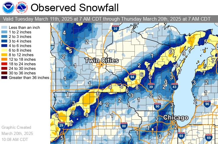 Observed Snowfall Analysis |
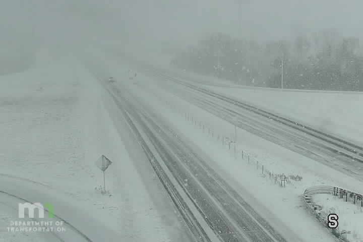
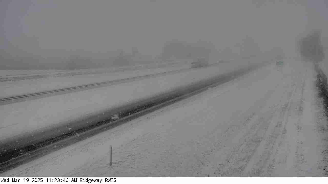
Photos/GIFs:
 |
 |
 |
 |
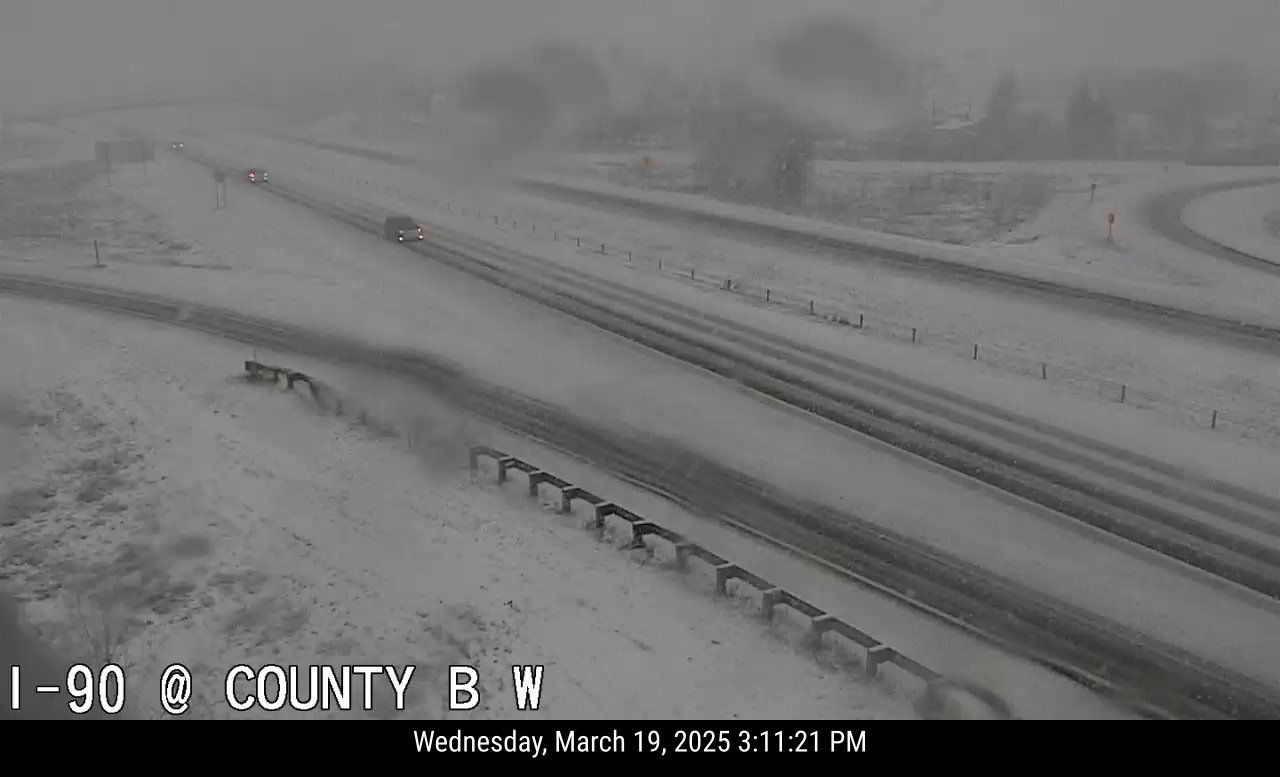
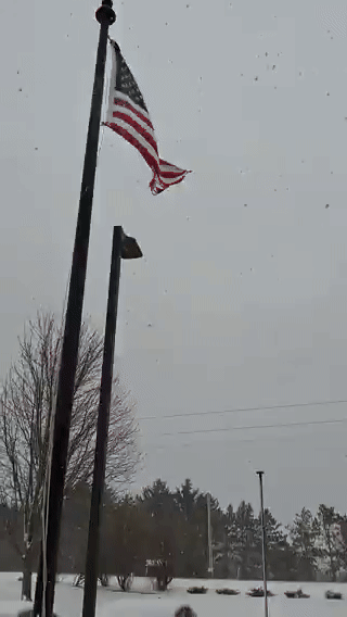
| Courtesy of MnDOT | Courtesy of Iowa DOT | Courtesy of WisDOT | Snowfall at NWS La Crosse |
 |
 |
| "Dirty Rain" at NWS La Crosse | Multiple Precipitation Types at NWS La Crosse |
Service
 |
 |
 |
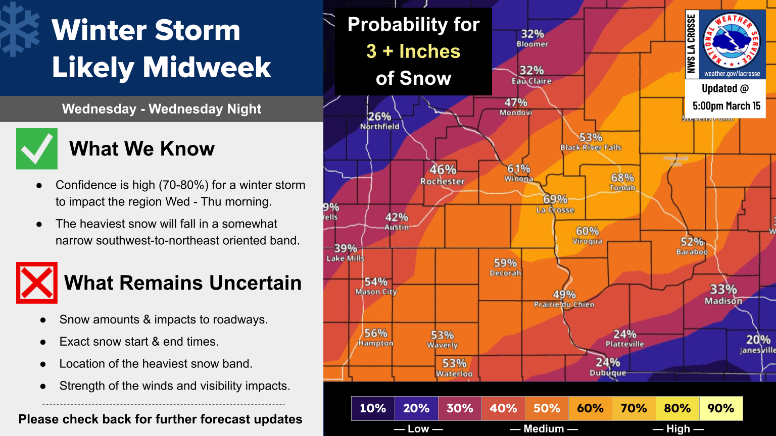
| Snowfall Probabilities - Issued March 15, 2025 | Expected Snowfall and Hazards - Issued March 19, 2025 | Forecast Update/Current Conditions - Issued During Event |
Impacts / Additional Observations
 |
 |
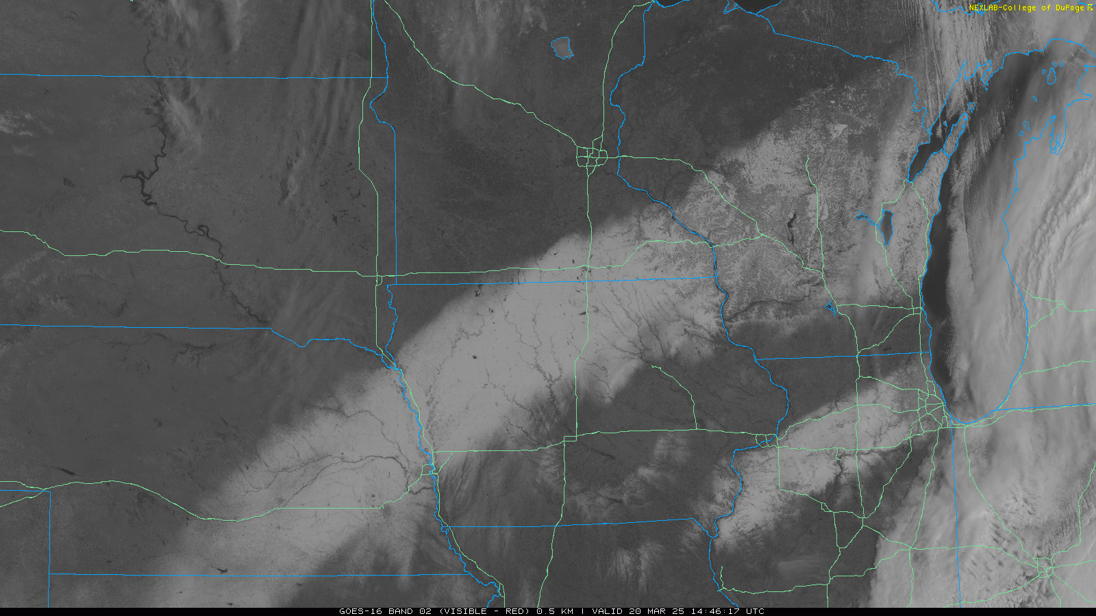 |
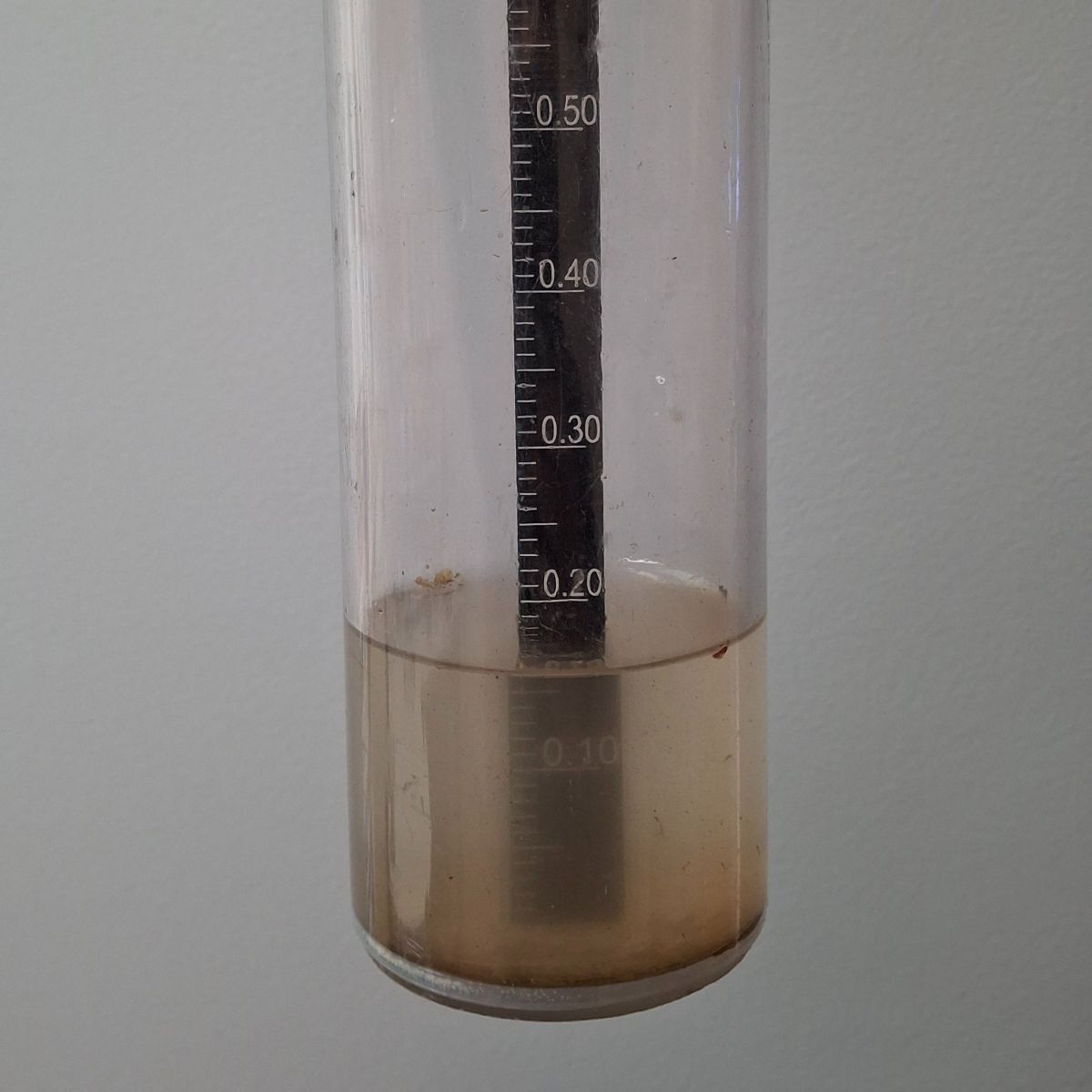
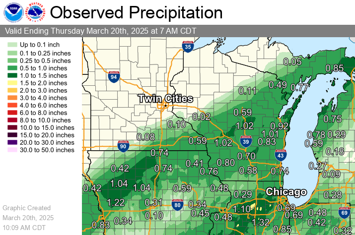
| Winter Storm Severity Index - March 19, 2025 | Observed Liquid Precipitation | March 20, 2025 Visible Satellite Image - Courtesy of College of DuPage |
 |
Media use of NWS Web News Stories is encouraged! Please acknowledge the NWS as the source of any news information accessed from this site. |
|


 Weather Story
 Weather Map
 Local Radar