Overview
|
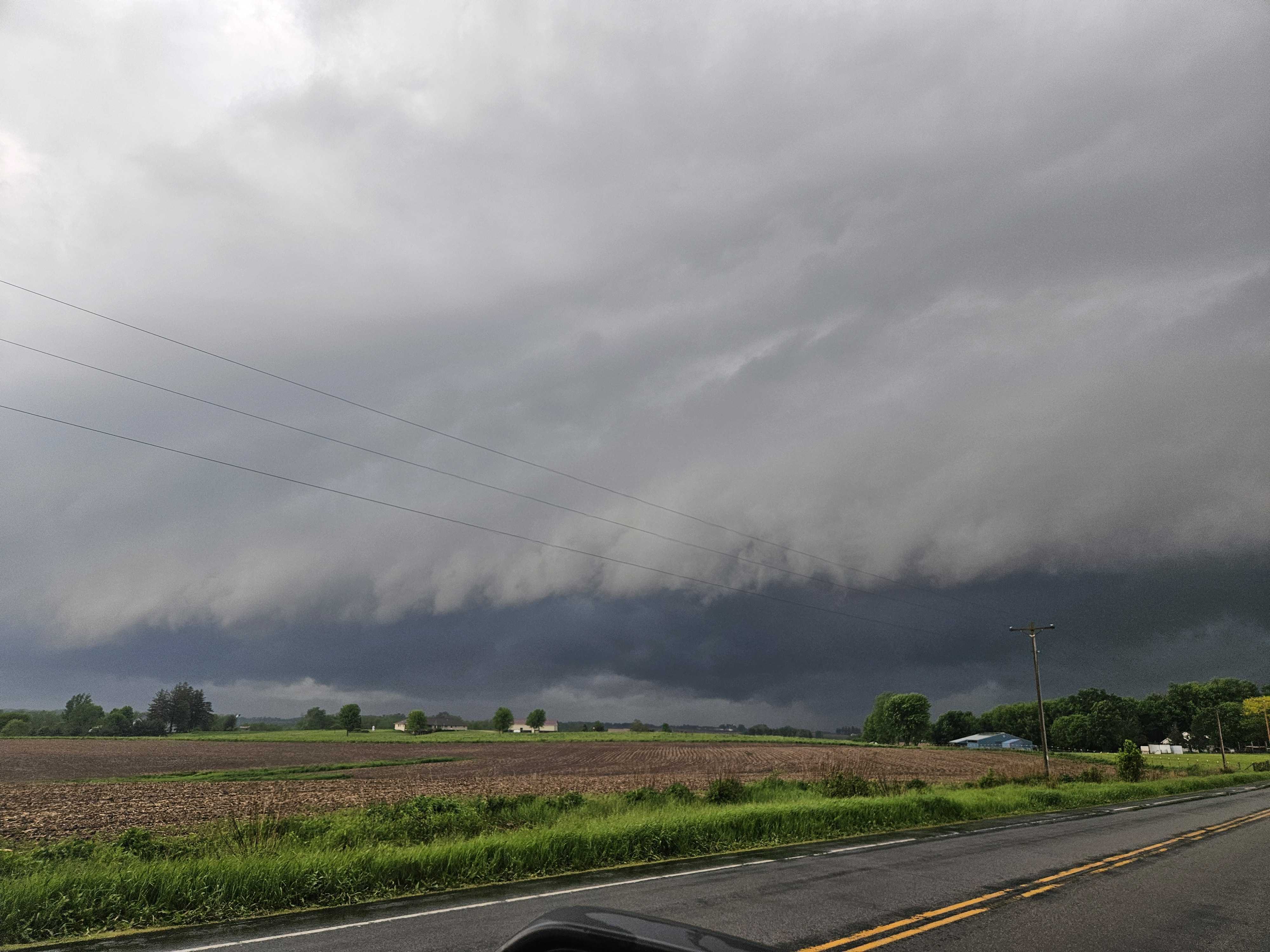
Multiple rounds of storms moved through the Upper Mississippi River Valley on Tuesday, May 21st. During the morning hours, non-severe storms produced heavy rainfall and frequent lightning. By early afternoon there was a lull in precipitation that helped the atmosphere recover and reenergize ahead of a fast-moving line of severe storms moving across Iowa.
|
 Radar Reflectivity Loop (4-10pm CDT) |
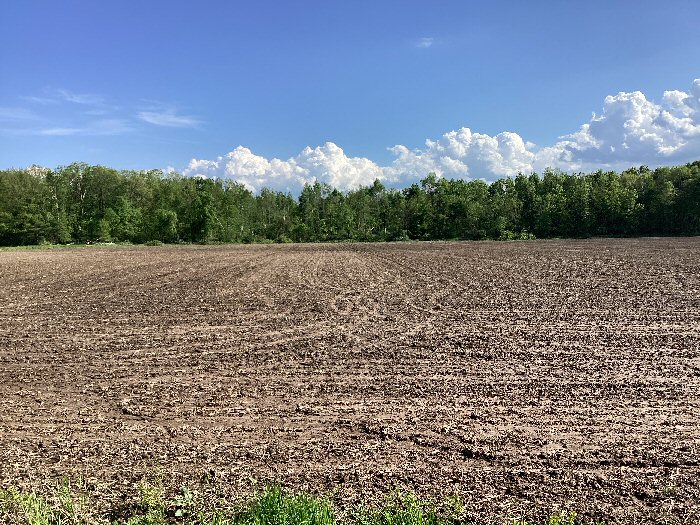
Tornadoes:
|
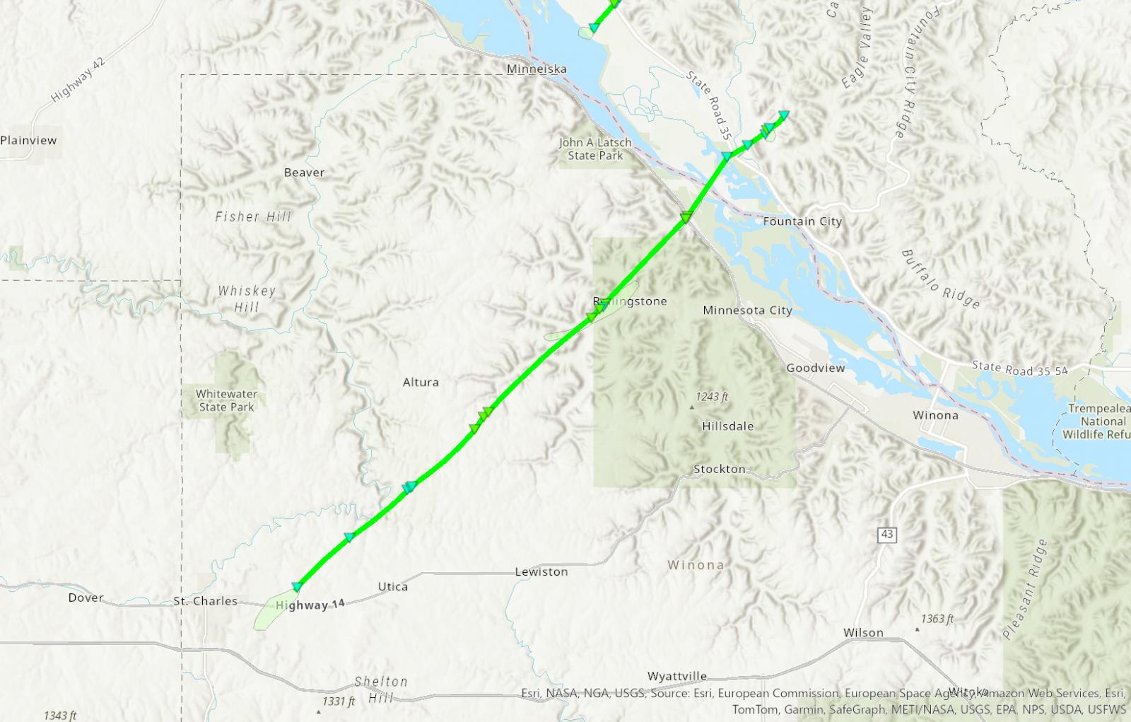
Tornado - Winona Co / Rollingstone
|
||||||||||||||||
|
||||||||||||||||
|
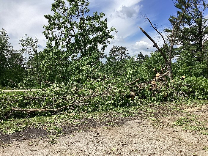
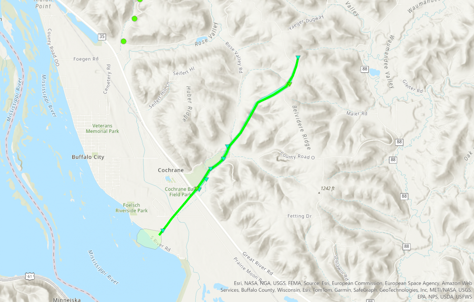
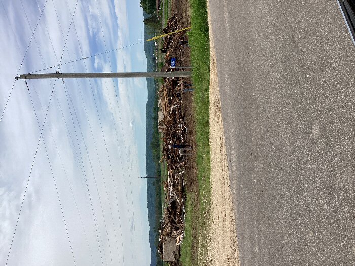
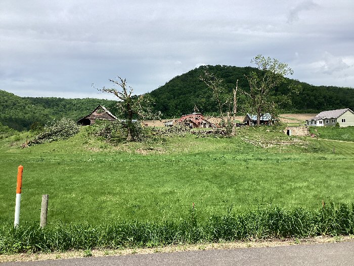
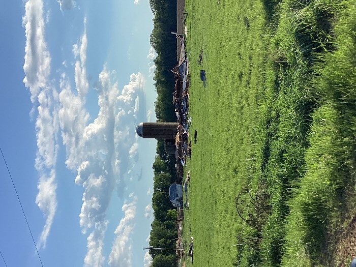
Tornado - Cochrane
|
||||||||||||||||
|
||||||||||||||||
|
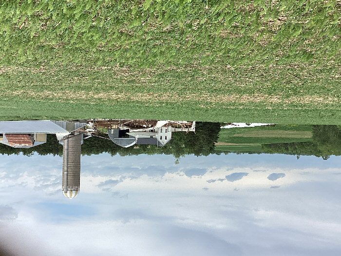
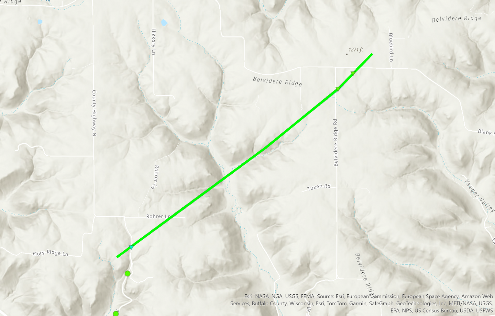
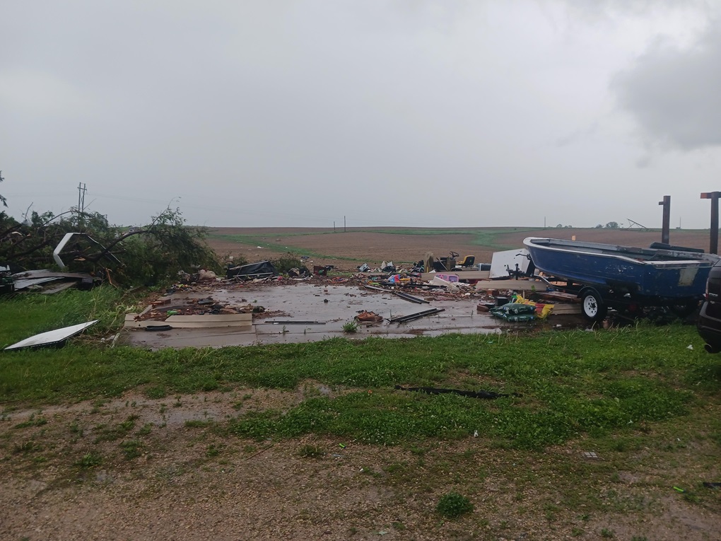
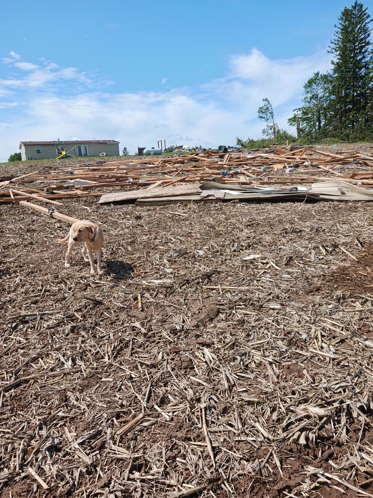
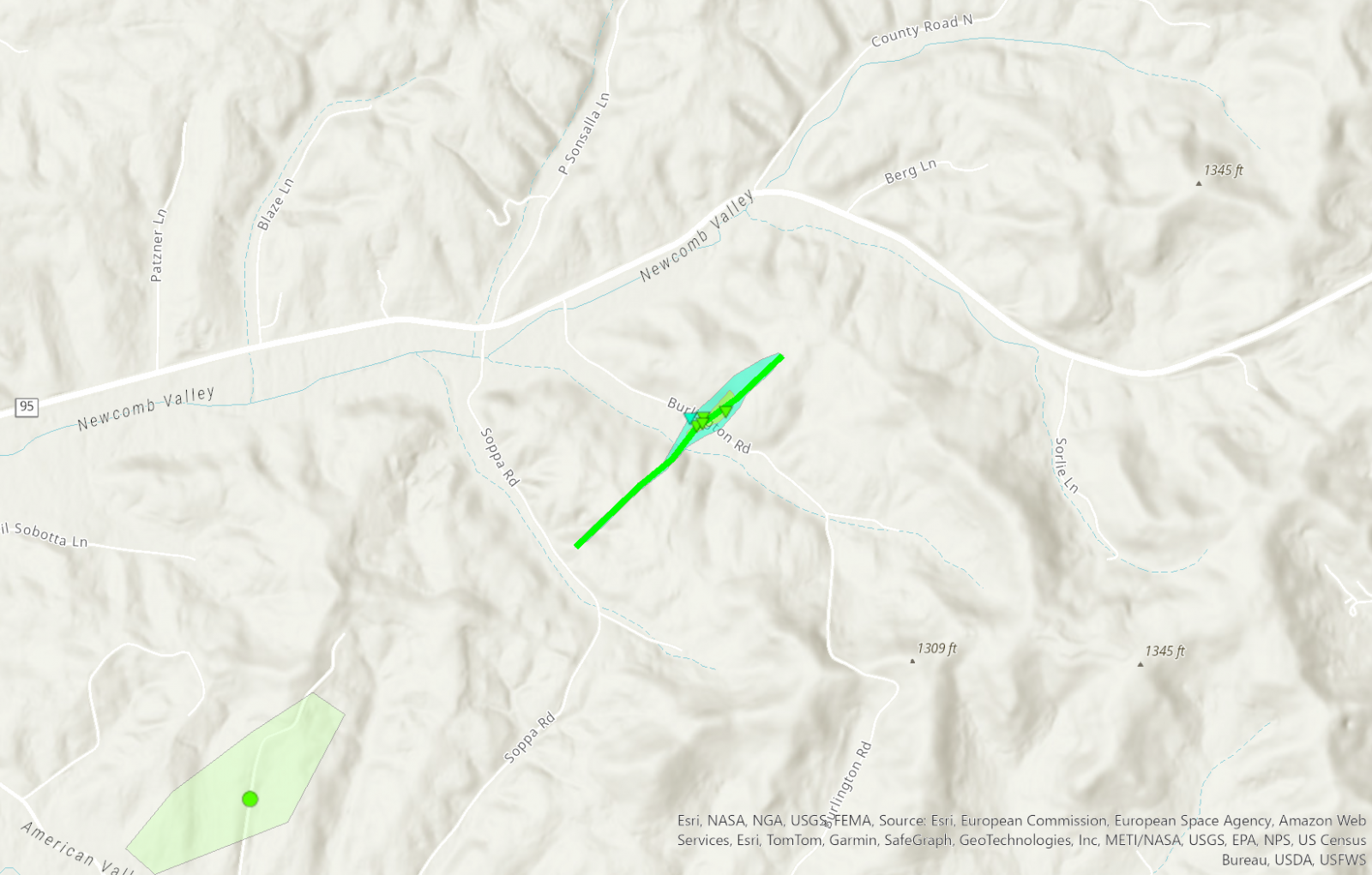
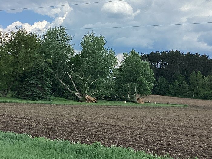
Tornado - Belvidere Ridge
|
||||||||||||||||
|
||||||||||||||||
|
Tornado - 5 mi E Arcadia
|
||||||||||||||||
|
||||||||||||||||
|
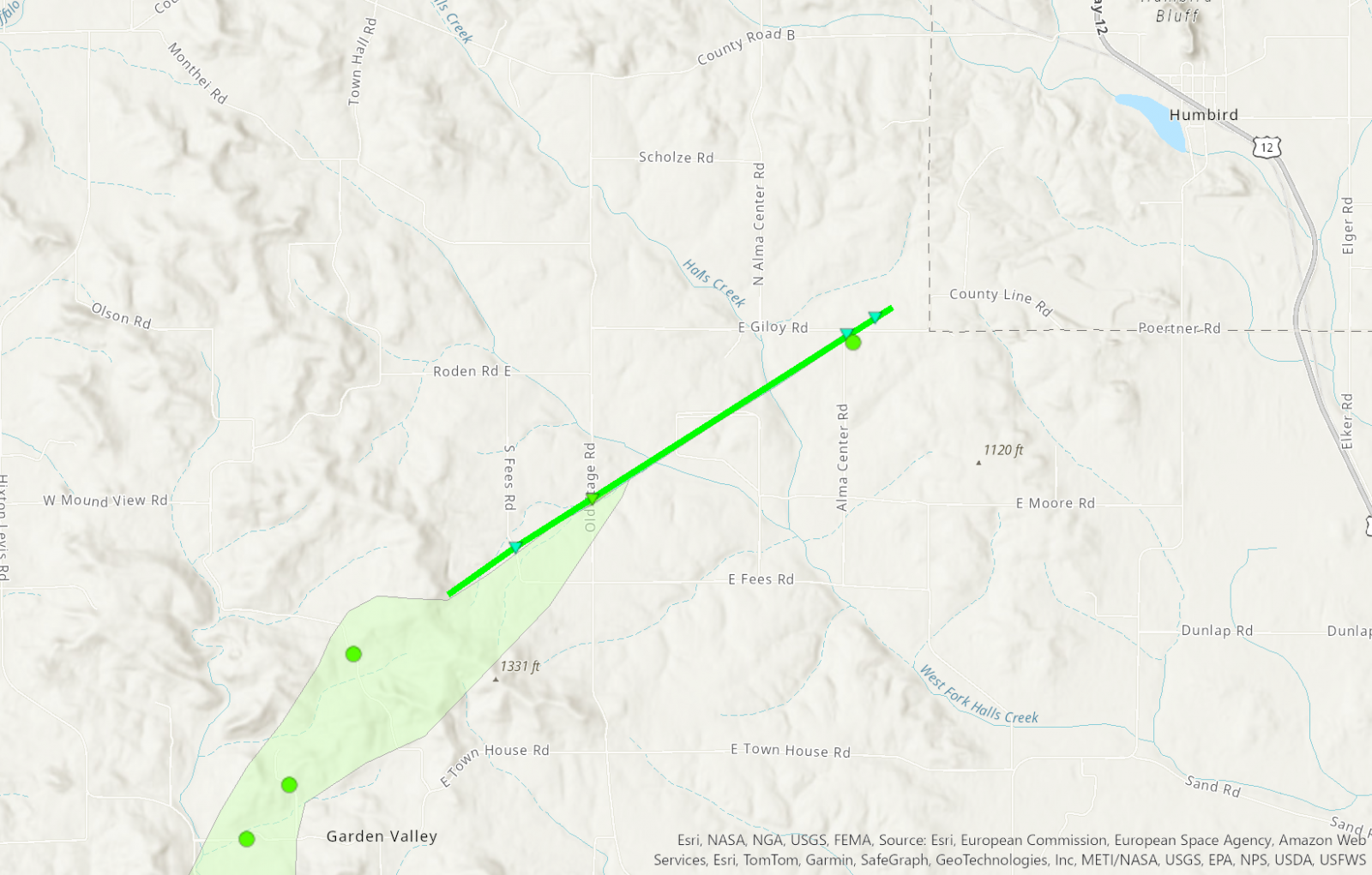
Tornado - NW of Alma Center
|
||||||||||||||||
|
||||||||||||||||
|
Tornado - NW of Neillsville
|
||||||||||||||||
|
||||||||||||||||
|
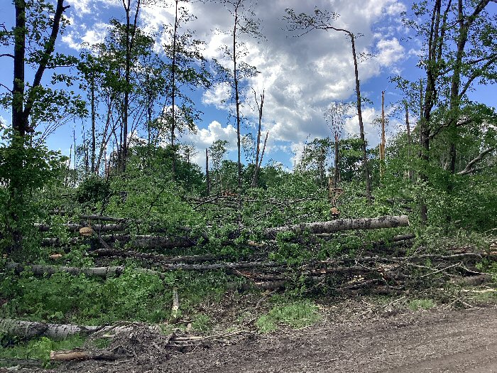
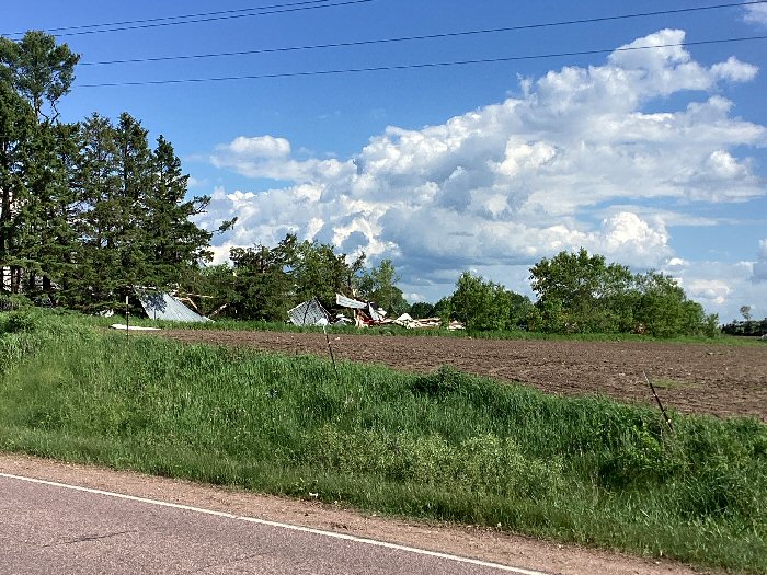
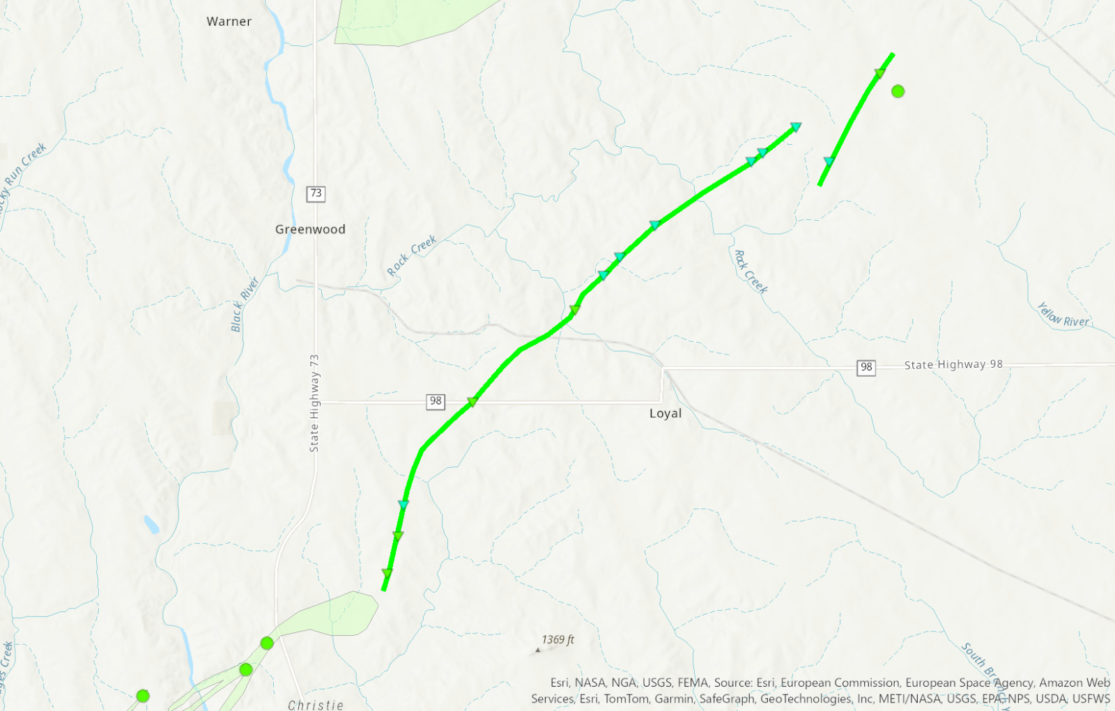
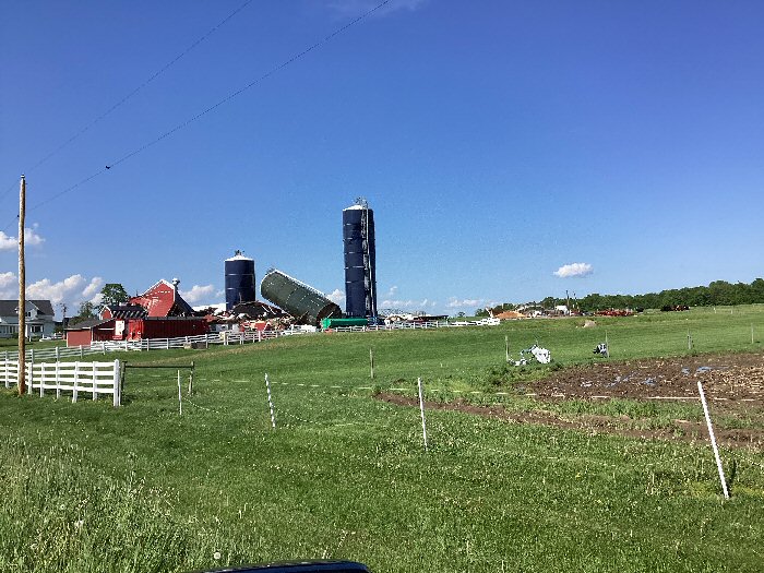
Tornado - NW of Loyal
|
||||||||||||||||
|
||||||||||||||||
|
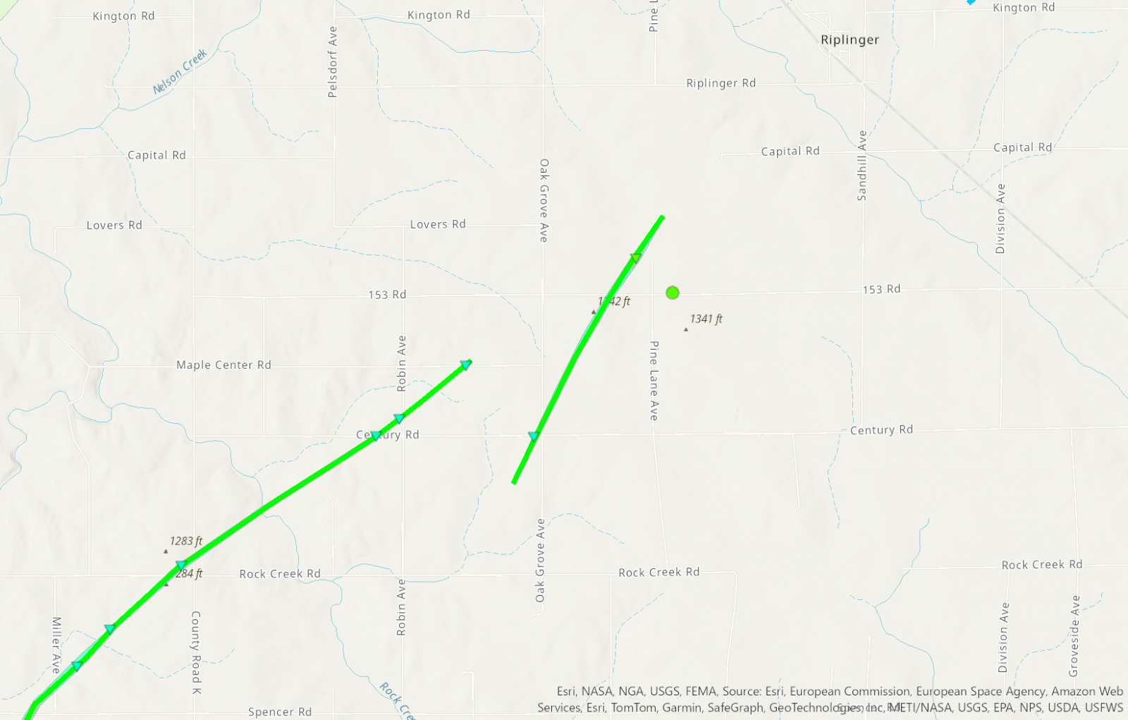
Tornado - SW of Atwood
|
||||||||||||||||
|
||||||||||||||||
|
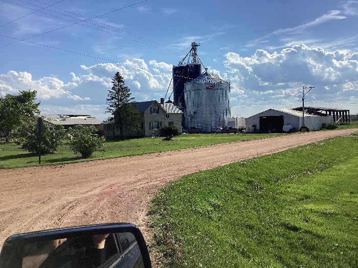
Tornado - SW of Riplinger
|
||||||||||||||||
|
||||||||||||||||
|
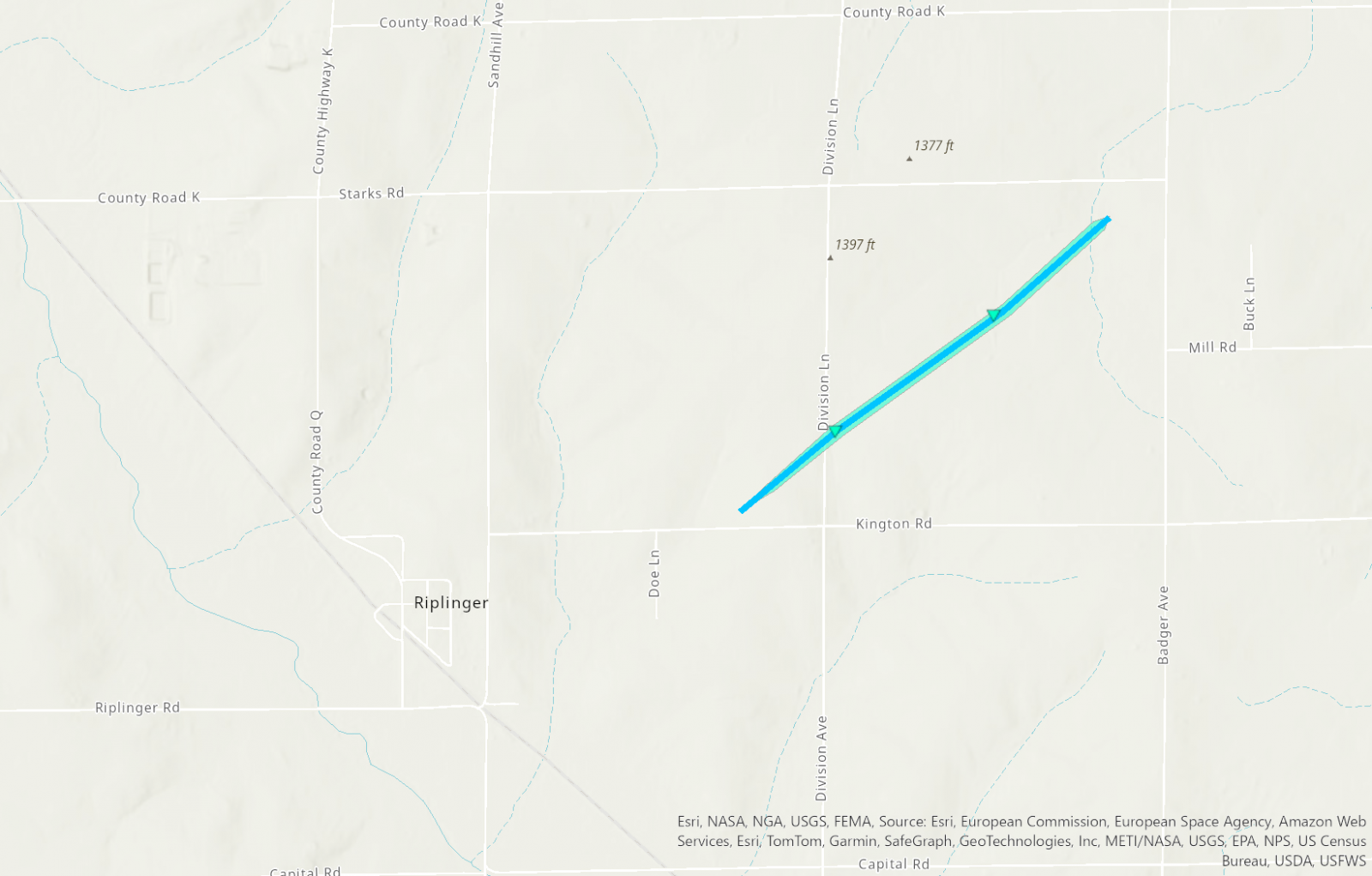
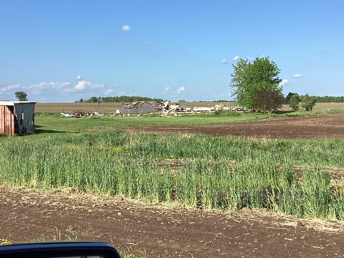
Tornado - NE of Riplinger
|
||||||||||||||||
|
||||||||||||||||
|
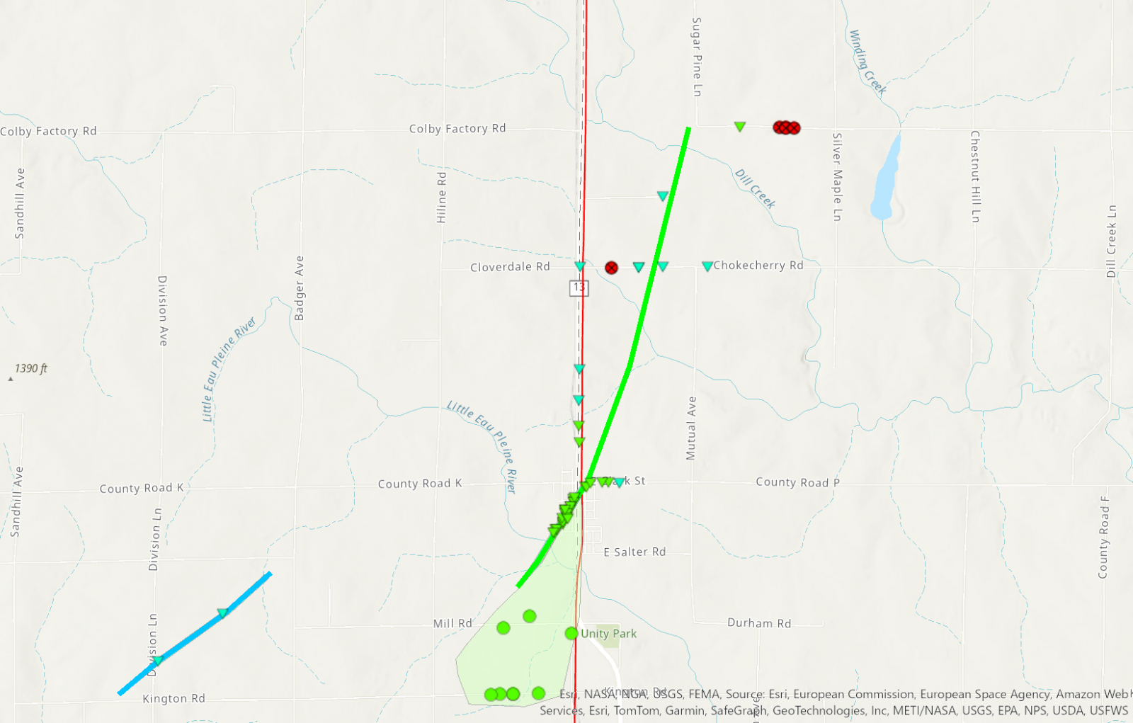
Tornado - Unity
|
||||||||||||||||
|
||||||||||||||||
| EF0 Weak 65-85 mph |
EF1 Moderate 86-110 mph |
EF2 Significant 111-135 mph |
EF3 Severe 136-165 mph |
EF4 Extreme 166-200 mph |
EF5 Catastrophic 200+ mph |
 |
|||||
Wind & Hail:
Wind
Public Information Statement
National Weather Service La Crosse WI
1111 AM CDT Wed May 22 2024

...HIGHEST OBSERVED WIND REPORTS MAY 21 2024...

Location                     Speed     Time/Date

I-90 Eb At Ush 53 Nb         65 MPH    0651 PM 05/21
New Hampton                  64 MPH    0605 PM 05/21
La Crosse Regional Airport   63 MPH    0641 PM 05/21
T.h.52 - Canton - Mp 2       63 MPH    0615 PM 05/21
U.s.218 - Lyle - Mp 4        60 MPH    0530 PM 05/21
Rochester International Airp 59 MPH    0546 PM 05/21
U.s.14 - Byron - Mp 200      59 MPH    0540 PM 05/21
Lancaster                    57 MPH    0841 PM 05/21
I-90 - Eyota - Mp 226        57 MPH    0600 PM 05/21
U.s.63 - Le Roy - Mp 0.5     57 MPH    0555 PM 05/21
Greenwood                    56 MPH    0725 PM 05/21
Saratoga                     54 MPH    0535 PM 05/21
Lancaster                    54 MPH    0805 PM 05/21
Mayo Helipad                 53 MPH    0555 PM 05/21
I-90 - Dexter - Mp 195       53 MPH    0535 PM 05/21
Platteville Municipal Airpor 52 MPH    0655 PM 05/21
Sparta/Fort McCoy Airport    51 MPH    0717 PM 05/21
Volk Field                   51 MPH    0746 PM 05/21
I-90 - Ridgeway - Mp 261     50 MPH    0635 PM 05/21
U.s.63 - Stewartville - Mp 3 50 MPH    0550 PM 05/21
Charles City Airport         49 MPH    0555 PM 05/21
Decorah                      48 MPH    0635 PM 05/21
Onalaska                     47 MPH    0656 PM 05/21
Greene                       46 MPH    0515 PM 05/21
Westboro                     46 MPH    0815 PM 05/21
Preston Airport              46 MPH    0555 PM 05/21
Saratoga                     45 MPH    0545 PM 05/21
Oelwein Municipal Airport    45 MPH    0655 PM 05/21
Winona Municipal Airport     45 MPH    0615 PM 05/21
Prairie Du Chien  Airport    45 MPH    0735 PM 05/21
3 NE Lublin                  44 MPH    0814 PM 05/21
Necedah                      44 MPH    0848 PM 05/21
Decorah Municipal Airport    41 MPH    0635 PM 05/21
Boscobel                     40 MPH    0603 PM 05/21
Mauston Airport              40 MPH    0815 PM 05/21
Boscobel Airport             40 MPH    0600 PM 05/21
Dodge Center Airport         40 MPH    0535 PM 05/21
Lyle                         39 MPH    0510 PM 05/21
Rochester                    39 MPH    1215 PM 05/21
Black River Falls            39 MPH    0710 PM 05/21
Hawkeye                      37 MPH    1205 AM 05/22
U.s.63 - Lake City - Mp 62.9 37 MPH    1155 AM 05/21
U.s.61 - Winona              37 MPH    0650 PM 05/21
1 E Black River Falls        36 MPH    0715 PM 05/21
Steuben                      36 MPH    0725 PM 05/21
Austin Municipal Airport     36 MPH    0115 AM 05/22
Crawford Co. Sth 27 Sb 0.25  36 MPH    0720 PM 05/21
Hayfield                     35 MPH    0527 PM 05/21
Monona                       35 MPH    0659 PM 05/21
Uscrn Site Near Necedah 5wnw 35 MPH    0800 PM 05/21
Platteville                  34 MPH    0855 PM 05/21
Saint Ansgar                 33 MPH    1125 AM 05/21
Black River Falls Area Airpo 33 MPH    0715 PM 05/21
Austin                       32 MPH    1125 AM 05/21
Riceville                    32 MPH    0615 PM 05/21
2 NE Dougherty               31 MPH    0535 PM 05/21
T.h.44 - Hokah - Mp 60       31 MPH    0645 PM 05/21
Hail
..TIME...   ...EVENT...      ...CITY LOCATION...     ...LAT.LON...
..DATE...   ....MAG....      ..COUNTY LOCATION..ST.. ...SOURCE....
            ..REMARKS..

0357 PM     Hail             Dickeyville             42.63N 90.59W
05/21/2024  M1.00 Inch       Grant              WI   Emergency Mngr


0400 PM     Hail             Dickeyville             42.63N 90.59W
05/21/2024  M1.75 Inch       Grant              WI   Law Enforcement


0404 PM     Hail             Platteville             42.74N 90.48W
05/21/2024  M0.50 Inch       Grant              WI   Fire Dept/Rescue


0411 PM     Hail             Platteville             42.74N 90.48W
05/21/2024  E0.70 Inch       Grant              WI   Public


0413 PM     Hail             2 NNW Platteville       42.76N 90.50W
05/21/2024  M0.50 Inch       Grant              WI   Public
0529 PM     Hail             5 ESE Douglas           44.09N 92.48W
05/21/2024  M0.25 Inch       Olmsted            MN   Cocorahs
0531 PM     Hail             3 NNE Rochester         44.05N 92.45W
05/21/2024  M0.75 Inch       Olmsted            MN   Public
0539 PM     Hail             3 SSW Zumbro Falls      44.24N 92.45W
05/21/2024  M0.25 Inch       Wabasha            MN   Cocorahs
0614 PM     Hail             Platteville             42.74N 90.48W
05/21/2024  E1.50 Inch       Grant              WI   Broadcast Media
0618 PM     Hail             1 NW Platteville        42.74N 90.49W
05/21/2024  M1.00 Inch       Grant              WI   Public
0636 PM     Hail             1 NW Platteville        42.74N 90.49W
05/21/2024  E1.00 Inch       Grant              WI   Public

            Report from mPING: Quarter (1.00 in.).
0744 PM     Hail             2 SSE Patch Grove       42.91N 90.96W
05/21/2024  M0.70 Inch       Grant              WI   Public
0803 PM     Hail             3 NW Burton             42.75N 90.84W
05/21/2024  E0.75 Inch       Grant              WI   Public
Rain Reports
Public Information Statement
National Weather Service La Crosse WI
442 AM CDT Wed May 22 2024

...24 HOUR RAIN REPORTS...

Location                     Amount    Time/Date       Lat/Lon

...Iowa...

...Allamakee County...
3 S Dorchester               1.86 in   0400 AM 05/22   43.42N/91.51W

...Chickasaw County...
Ionia 2W                     2.65 in   0345 AM 05/22   43.03N/92.50W
New Hampton                  2.42 in   0427 AM 05/22   43.05N/92.30W

...Clayton County...
Mcgregor                     2.73 in   0434 AM 05/22   43.02N/91.19W
1 WSW Marquette              1.88 in   0400 AM 05/22   43.04N/91.21W
Littleport                   1.88 in   0345 AM 05/22   42.75N/91.37W
Monona                       1.74 in   0434 AM 05/22   43.04N/91.39W
Big Spring Fish Hatchery     0.96 in   0400 AM 05/22   42.91N/91.47W

...Floyd County...
Charles City                 3.69 in   0606 PM 05/21   43.05N/92.67W
2 NE Dougherty               1.73 in   0430 AM 05/22   42.95N/93.01W

...Howard County...
Saratoga                     1.96 in   0415 AM 05/22   43.35N/92.42W
Riceville                    1.44 in   0430 AM 05/22   43.36N/92.48W

...Mitchell County...
Stacyville                   0.52 in   0426 AM 05/22   43.44N/92.78W

...Winneshiek County...
Decorah                      2.07 in   0700 PM 05/21   43.30N/91.80W
Decorah                      1.51 in   0434 AM 05/22   43.30N/91.79W
Decorah Municipal Airport    1.37 in   0415 AM 05/22   43.27N/91.72W
1 ENE Jackson Junction       1.17 in   0435 AM 05/22   43.11N/92.04W

...Minnesota...

...Dodge County...
Hayfield                     0.95 in   0427 AM 05/22   43.89N/92.85W

...Fillmore County...
Lanesboro                    1.21 in   0430 AM 05/22   43.72N/91.98W
1 NNW Fillmore               0.60 in   0430 AM 05/22   43.76N/92.27W

...Houston County...
Mound Prairie                1.87 in   1100 PM 05/21   43.78N/91.45W
Hokah                        1.37 in   0430 AM 05/22   43.80N/91.43W

...Mower County...
AUSTIN                       1.08 in   0428 AM 05/22   43.65N/93.00W
Austin 3 NW - Turtle Creek   0.76 in   0330 AM 05/22   43.65N/92.98W
Dobbins Creek                0.72 in   0330 AM 05/22   43.68N/92.94W
Lansing - Cedar River        0.71 in   0330 AM 05/22   43.75N/92.96W

...Olmsted County...
Rochester                    2.55 in   0415 AM 05/22   44.04N/92.44W
6 NNW Genoa                  1.09 in   0400 AM 05/22   44.19N/92.65W
Rochester                    1.07 in   0430 AM 05/22   44.09N/92.51W
3 W Rochester                0.89 in   0330 AM 05/22   44.02N/92.53W
Elba 4.7 SW                  0.82 in   0900 PM 05/21   44.04N/92.09W
Rochester-Cascade Creek      0.69 in   0330 AM 05/22   44.03N/92.47W
Eyota 2NE                    0.69 in   0330 AM 05/22   44.02N/92.20W
3 ENE Rochester              0.68 in   0330 AM 05/22   44.03N/92.43W
Chatfield 1.7 NE             0.65 in   0800 PM 05/21   43.86N/92.17W
Byron                        0.64 in   0430 AM 05/22   44.04N/92.64W
1 W Oronoco                  0.64 in   0430 AM 05/22   44.17N/92.55W
Mayo Helipad                 0.58 in   0415 AM 05/22   44.02N/92.48W
Rochester International Airp 0.55 in   0354 AM 05/22   43.90N/92.50W
Stewartville 4.3 E           0.51 in   0430 AM 05/22   43.86N/92.40W
Rochester-Beltline Bear Cree 0.51 in   0330 AM 05/22   44.01N/92.45W
5 WSW Rochester              0.47 in   0400 AM 05/22   43.98N/92.56W
Rochester                    0.44 in   0425 AM 05/22   44.05N/92.45W
Byron                        0.43 in   0434 AM 05/22   44.03N/92.63W
Rochester 1.9 SSE            0.41 in   0530 PM 05/21   43.99N/92.47W
Rochester                    0.28 in   0545 PM 05/21   44.18N/92.41W

...Wabasha County...
Lake City                    1.50 in   0430 AM 05/22   44.44N/92.28W
3 ESE Mazeppa                0.76 in   0430 AM 05/22   44.26N/92.49W
1 N Kellogg                  0.31 in   0400 AM 05/22   44.32N/92.00W

...Winona County...
Plainview                    0.84 in   0415 AM 05/22   44.05N/91.65W
Whitewater State Park        0.70 in   0330 AM 05/22   44.05N/92.05W
1 WSW Elba                   0.68 in   0345 AM 05/22   44.09N/92.03W
Beaver                       0.62 in   0345 AM 05/22   44.15N/92.00W
La Crescent 4.0 NNW          0.40 in   0425 AM 05/22   43.88N/91.34W
1 ESE Winona                 0.37 in   0430 AM 05/22   44.04N/91.63W
3 NE Nodine                  0.34 in   0330 AM 05/22   43.94N/91.41W
3 SW Elba                    0.18 in   0330 AM 05/22   44.06N/92.05W

...Wisconsin...

...Buffalo County...
Mondovi                      0.48 in   0700 PM 05/21   44.56N/91.67W

...Clark County...
COLBY                        1.23 in   0426 AM 05/22   44.91N/90.32W
Colby 5.9 WSW                0.19 in   0700 PM 05/21   44.87N/90.42W

...Crawford County...
Prairie Du Chien  Airport    1.83 in   0415 AM 05/22   43.02N/91.12W
Steuben                      1.62 in   0345 AM 05/22   43.18N/90.86W
2.8 E Harpers Ferry          0.97 in   0415 AM 05/22   43.21N/91.10W

...Grant County...
Boscobel Airport             2.47 in   0427 AM 05/22   43.15N/90.68W
Boscobel                     2.34 in   0403 AM 05/22   43.15N/90.68W
Platteville                  0.93 in   0425 AM 05/22   42.74N/90.46W
Lancaster                    0.57 in   0341 AM 05/22   42.83N/90.69W
Platteville Municipal Airpor 0.34 in   0415 AM 05/22   42.68N/90.43W

...Jackson County...
1 E Black River Falls        1.66 in   0415 AM 05/22   44.30N/90.73W
Black River Falls Area Airpo 1.07 in   0415 AM 05/22   44.25N/90.85W

...Juneau County...
NECEDAH NWR RY DAM NECEDAH 5 4.32 in   0410 AM 05/22   44.06N/90.17W
New Lisbon                   2.78 in   0430 AM 05/22   43.87N/90.17W
Necedah                      2.16 in   0348 AM 05/22   44.03N/90.08W
Volk Field                   1.28 in   0432 AM 05/22   43.93N/90.27W
Mauston Airport              0.04 in   0415 AM 05/22   43.83N/90.13W

...La Crosse County...
Burns                        1.62 in   0427 AM 05/22   43.91N/90.97W
Onalaska                     1.53 in   0426 AM 05/22   43.89N/91.18W
Bangor                       1.45 in   0430 AM 05/22   43.89N/90.99W
La Crosse Regional Airport   1.29 in   0403 AM 05/22   43.88N/91.25W
La Crosse                    1.08 in   0645 PM 05/21   43.77N/91.22W

...Monroe County...
Sparta/Fort McCoy Airport    1.13 in   0406 AM 05/22   43.97N/90.73W

...Taylor County...
Medford                      0.77 in   0415 AM 05/22   45.30N/90.30W
3 NE Lublin                  0.76 in   0414 AM 05/22   45.11N/90.69W
Westboro                     0.76 in   0415 AM 05/22   45.37N/90.31W
Medford Airport              0.57 in   0415 AM 05/22   45.10N/90.30W

...Trempealeau County...
0.8 SW Pigeon Falls (IFLOWS) 1.18 in   1001 PM 05/21   44.42N/91.22W
2 ENE Marshland              0.88 in   0430 AM 05/22   44.09N/91.51W
Blair (IFLOWS)               0.78 in   0319 AM 05/22   44.30N/91.23W
Trempealeau                  0.72 in   0427 AM 05/22   44.07N/91.51W
Whitehall (IFLOWS)           0.59 in   0846 PM 05/21   44.37N/91.32W

...Vernon County...
La Farge                     3.18 in   0415 AM 05/22   43.60N/90.63W
Readstown                    2.08 in   0400 AM 05/22   43.45N/90.77W
Genoa                        1.08 in   0421 AM 05/22   43.56N/91.22W
Genoa Dam 8                  0.55 in   0415 AM 05/22   43.57N/91.23W

Observations are collected from a variety of sources with varying
equipment and exposures. We thank all volunteer weather observers
for their dedication. Not all data listed are considered official.
Storm Reports
Preliminary Local Storm Report...Summary
National Weather Service La Crosse WI
852 PM CDT Tue May 21 2024
..TIME... ...EVENT... ...CITY LOCATION... ...LAT.LON...
..DATE... ....MAG.... ..COUNTY LOCATION..ST.. ...SOURCE....
..REMARKS..
0357 PM Hail Dickeyville 42.63N 90.59W
05/21/2024 M1.00 Inch Grant WI Emergency Mngr
0400 PM Hail Dickeyville 42.63N 90.59W
05/21/2024 M1.75 Inch Grant WI Law Enforcement
0404 PM Hail Platteville 42.74N 90.48W
05/21/2024 M0.50 Inch Grant WI Fire Dept/Rescue
0411 PM Hail Platteville 42.74N 90.48W
05/21/2024 E0.70 Inch Grant WI Public
0413 PM Hail 2 NNW Platteville 42.76N 90.50W
05/21/2024 M0.50 Inch Grant WI Public
0515 PM Tstm Wnd Dmg 2 S Saint Ansgar 43.35N 92.92W
05/21/2024 Mitchell IA Law Enforcement
Power lines blown over and grain bin
destroyed.
0520 PM Tstm Wnd Dmg 2 SW Austin 43.65N 93.00W
05/21/2024 Mower MN Public
Report from mPING: Trees uprooted or
snapped; Roof blown off.
0521 PM Tstm Wnd Dmg 1 E Austin 43.67N 92.95W
05/21/2024 Mower MN Public
Large tree limb down.
0523 PM Tstm Wnd Dmg Hayfield 43.89N 92.85W
05/21/2024 Dodge MN Emergency Mngr
Tree damage reported.
0523 PM Tstm Wnd Dmg 2 W Kasson 44.03N 92.80W
05/21/2024 Dodge MN Emergency Mngr
Power lines and semi truck blown over along
Highway 14 and 220th Ave.
0524 PM Tstm Wnd Gst West Concord 44.15N 92.90W
05/21/2024 E50 MPH Dodge MN Fire Dept/Rescue
0525 PM Tstm Wnd Dmg 1 W Rose Creek 43.61N 92.85W
05/21/2024 Mower MN Public
Report from mPING: 3-inch tree limbs broken;
Power poles broken.
0529 PM Hail 5 ESE Douglas 44.09N 92.48W
05/21/2024 M0.25 Inch Olmsted MN Cocorahs
0530 PM Tstm Wnd Dmg 2 S Rochester 43.99N 92.47W
05/21/2024 Olmsted MN Public
15 to 20 inch diameter tree blown down.
0531 PM Hail 3 NNE Rochester 44.05N 92.45W
05/21/2024 M0.75 Inch Olmsted MN Public
0535 PM Tstm Wnd Gst 1 NW Taopi 43.56N 92.65W
05/21/2024 E64 MPH Mower MN Trained Spotter
0535 PM Tstm Wnd Dmg 1 E Austin 43.67N 92.96W
05/21/2024 Mower MN Public
Report from mPING: Trees uprooted or
snapped; Roof blown off.
0538 PM Tstm Wnd Gst 1 S Harmony 43.54N 92.01W
05/21/2024 M72 MPH Fillmore MN Fire Dept/Rescue
Fire Dept. Rescue squad measured 72 mph wind
gust in the town of Harmony.
0538 PM Tstm Wnd Dmg 1 S Harmony 43.54N 92.01W
05/21/2024 Fillmore MN Fire Dept/Rescue
Fire Dept. rescue squad reported 2 trees
down in town of Harmony.
0539 PM Hail 3 SSW Zumbro Falls 44.24N 92.45W
05/21/2024 M0.25 Inch Wabasha MN Cocorahs
0539 PM Tstm Wnd Dmg Spring Valley 43.69N 92.39W
05/21/2024 Fillmore MN Trained Spotter
Power lines down.
0541 PM Tstm Wnd Dmg Kasson 44.03N 92.75W
05/21/2024 Dodge MN Public
Large tree split. Also downed large branches
and power lines and a rolled semi on Highway
14.
0541 PM Tstm Wnd Dmg 1 SE Marble Rock 42.96N 92.85W
05/21/2024 Floyd IA Public
Report from mPING: 1-inch tree limbs broken;
Shingles blown off.
0546 PM Tstm Wnd Dmg 1 NW Rochester 44.02N 92.49W
05/21/2024 Olmsted MN Public
Large branches down in northwest Rochester.
0548 PM Tstm Wnd Gst Greenleafton 43.58N 92.21W
05/21/2024 M64 MPH Fillmore MN Trained Spotter
0551 PM Tstm Wnd Dmg Chatfield 43.84N 92.19W
05/21/2024 Fillmore MN Public
Large tree split in half.
0552 PM Tstm Wnd Dmg Charles City 43.07N 92.67W
05/21/2024 Floyd IA Emergency Mngr
Trees and power lines down in town.
0554 PM Tstm Wnd Gst 3 NNW Stewartville 43.90N 92.50W
05/21/2024 E62 MPH Olmsted MN ASOS
Peak gust 51 kts.
0555 PM Tstm Wnd Dmg 1 NNW Elgin 44.15N 92.26W
05/21/2024 Wabasha MN Public
One pine tree branch down.
0555 PM Tstm Wnd Gst Marble Rock 42.97N 92.87W
05/21/2024 E60 MPH Floyd IA Fire Dept/Rescue
Damage reported in town.
0555 PM Tstm Wnd Gst Eyota 43.99N 92.23W
05/21/2024 E60 MPH Olmsted MN Trained Spotter
Small trees down and debris blowing through
fields.
0605 PM Tstm Wnd Dmg Lewiston 43.99N 91.87W
05/21/2024 Winona MN Emergency Mngr
Trees down.
0605 PM Tstm Wnd Gst Saint Charles 43.97N 92.07W
05/21/2024 E54 MPH Winona MN Emergency Mngr
Tree damage reported.
0608 PM Tstm Wnd Dmg Lewiston 43.98N 91.87W
05/21/2024 Winona MN Public
Several large trees down along South
Freemont Street.
0611 PM Tstm Wnd Dmg 3 N Kellogg 44.34N 92.00W
05/21/2024 Wabasha MN Public
Large pine tree snapped on County Road 24.
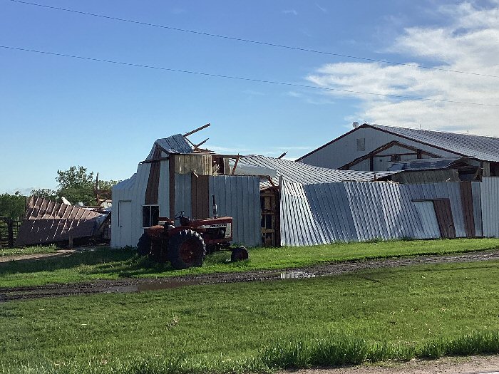
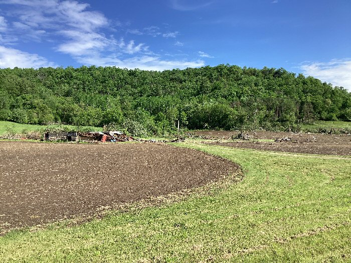
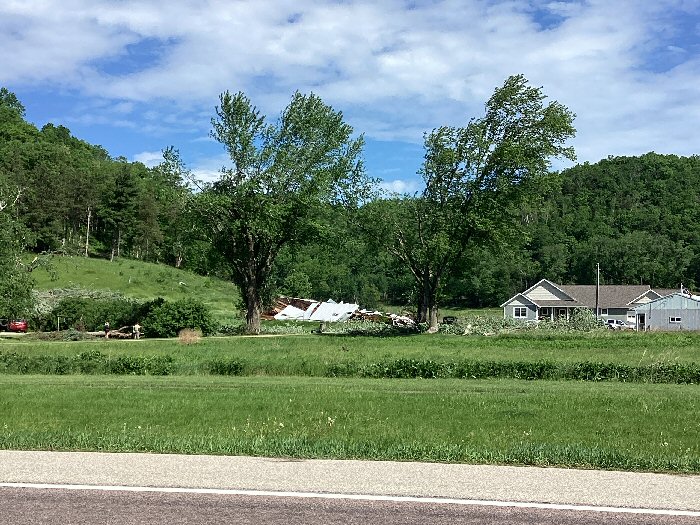
0611 PM Tstm Wnd Dmg 1 WSW Rollingstone 44.10N 91.83W
05/21/2024 Winona MN Emergency Mngr
Barn demolished and damage to another
building. Possible tornado.
0614 PM Hail Platteville 42.74N 90.48W
05/21/2024 E1.50 Inch Grant WI Broadcast Media
0615 PM Tstm Wnd Dmg 3 ENE Cochrane 44.25N 91.79W
05/21/2024 Buffalo WI Emergency Mngr
Main barn and heifer barn of a farmstead
destroyed. Trees snapped. Possible tornado
damage.
0615 PM Hail Livingston 42.90N 90.43W
05/21/2024 M0.88 Inch Grant WI Emergency Mngr
0618 PM Hail 1 NW Platteville 42.74N 90.49W
05/21/2024 M1.00 Inch Grant WI Public
0619 PM Tstm Wnd Dmg Winona 44.05N 91.66W
05/21/2024 Winona MN Public
Several trees and large limbs down within
the city.
0620 PM Tstm Wnd Dmg 1 SE Charles City 43.06N 92.67W
05/21/2024 Floyd IA Public
Report from mPING: 3-inch tree limbs broken;
Power poles broken.
0621 PM Tstm Wnd Dmg Waumandee 44.30N 91.70W
05/21/2024 Buffalo WI Law Enforcement
Barns and trees blown down.
0622 PM Tstm Wnd Dmg Houston 43.76N 91.57W
05/21/2024 Houston MN Public
Trees down in town.
0623 PM Tstm Wnd Gst 2 S Oelwein 42.64N 91.91W
05/21/2024 E70 MPH Fayette IA Emergency Mngr
0628 PM Tstm Wnd Dmg 1 E Charles City 43.07N 92.66W
05/21/2024 Floyd IA Public
Report from mPING: 3-inch tree limbs broken;
Power poles broken.
0629 PM Tstm Wnd Dmg 2 SE Winona 44.03N 91.63W
05/21/2024 Winona MN Public
0630 PM Tstm Wnd Dmg 2 SE Goodview 44.04N 91.69W
05/21/2024 Winona MN Public
0630 PM Tstm Wnd Dmg Trempealeau 44.01N 91.44W
05/21/2024 Trempealeau WI Public
Large tree snapped blocking most of South
Street.
0630 PM Tstm Wnd Dmg Spring Grove 43.56N 91.64W
05/21/2024 Houston MN Law Enforcement
Power lines down.
0630 PM Tstm Wnd Dmg 1 E Charles City 43.07N 92.66W
05/21/2024 Floyd IA Public
Report from mPING: 3-inch tree limbs broken;
Power poles broken.
0633 PM Tstm Wnd Dmg Elgin 44.13N 92.26W
05/21/2024 Wabasha MN Public
0636 PM Hail 1 NW Platteville 42.74N 90.49W
05/21/2024 E1.00 Inch Grant WI Public
Report from mPING: Quarter (1.00 in.).
0638 PM Tstm Wnd Dmg Fayette 42.84N 91.80W
05/21/2024 Fayette IA Amateur Radio
50 mph wind gusts knocked down trees near
town.
0640 PM Tstm Wnd Dmg Strum 44.55N 91.39W
05/21/2024 Trempealeau WI Emergency Mngr
Tree toppled on house.
0641 PM Tstm Wnd Dmg Elgin 44.13N 92.26W
05/21/2024 Wabasha MN Public
0641 PM Tstm Wnd Dmg 4 NE New Amsterdam 44.03N 91.27W
05/21/2024 La Crosse WI NWS Employee
A few 3 to 4 inch diameter branches down.
0642 PM Tstm Wnd Gst 1 NNW Onalaska 43.90N 91.23W
05/21/2024 M59 MPH La Crosse WI Trained Spotter
0642 PM Tstm Wnd Dmg 1 N La Crosse 43.84N 91.23W
05/21/2024 La Crosse WI Public
Large tree down over road in northside of La
Crosse.
0642 PM Tstm Wnd Dmg Onalaska 43.89N 91.22W
05/21/2024 La Crosse WI Public
Tree down on Wells Street.
0642 PM Tstm Wnd Gst Stoddard 43.66N 91.22W
05/21/2024 M49 MPH Vernon WI Public
0642 PM Tstm Wnd Dmg West Union 42.96N 91.81W
05/21/2024 Fayette IA Emergency Mngr
Trees and powerlines down, including a tree
down on a house. Also trees and powerlines
down in Elgin.
0644 PM Tstm Wnd Dmg Genoa 43.57N 91.23W
05/21/2024 Vernon WI Emergency Mngr
Power lines down Highways 56 and 35.
0645 PM Tstm Wnd Dmg 2 S La Crosse 43.80N 91.24W
05/21/2024 La Crosse WI NWS Employee
Several branches down, damaging some cars.
0647 PM Tstm Wnd Dmg West Salem 43.91N 91.09W
05/21/2024 La Crosse WI Trained Spotter
Tree damage near Highway 16.
0647 PM Tstm Wnd Gst 1 NNE French Island 43.87N 91.25W
05/21/2024 M63 MPH La Crosse WI ASOS
55 kts.
0648 PM Tstm Wnd Gst Stoddard 43.66N 91.22W
05/21/2024 M46 MPH Vernon WI Fire Dept/Rescue
0649 PM Tstm Wnd Dmg 1 N West Salem 43.91N 91.08W
05/21/2024 La Crosse WI Public
One small tree snapped.
0651 PM Tstm Wnd Dmg 2 N Onalaska 43.92N 91.21W
05/21/2024 La Crosse WI Public
Report from mPING: 1-inch tree limbs broken;
Shingles blown off.
0654 PM Tstm Wnd Gst 1 N Hazel Green 42.54N 90.44W
05/21/2024 M75 MPH Grant WI Fire Dept/Rescue
0654 PM Tstm Wnd Dmg 1 E Douglas 44.11N 92.56W
05/21/2024 Olmsted MN Public
Report from mPING: 3-inch tree limbs broken;
Power poles broken.
0659 PM Tstm Wnd Dmg 4 E Douglas 44.11N 92.49W
05/21/2024 Olmsted MN Public
Report from mPING: Trees uprooted or
snapped; Roof blown off.
0701 PM Tstm Wnd Dmg Cataract 44.09N 90.84W
05/21/2024 Monroe WI Public
Tree damage.
0702 PM Tstm Wnd Gst Cuba City 42.60N 90.43W
05/21/2024 E50 MPH Grant WI Law Enforcement
0702 PM Tstm Wnd Dmg 2 W Winona 44.04N 91.69W
05/21/2024 Winona MN Public
Report from mPING: Trees uprooted or
snapped; Roof blown off.
0703 PM Tstm Wnd Dmg Sparta 43.94N 90.81W
05/21/2024 Monroe WI Emergency Mngr
Trees and power lines down.
0705 PM Tstm Wnd Dmg Hillsboro 43.65N 90.34W
05/21/2024 Vernon WI Emergency Mngr
Trees down on home.
0706 PM Tstm Wnd Dmg 1 NW Retreat 43.46N 91.09W
05/21/2024 Vernon WI Public
Report from mPING: 1-inch tree limbs broken;
Shingles blown off.
0710 PM Tstm Wnd Dmg 5 WNW Sidney 44.58N 90.73W
05/21/2024 Clark WI Emergency Mngr
Power poles and lines down along Highway 10.
0719 PM Tstm Wnd Gst Tomah 43.98N 90.50W
05/21/2024 E60 MPH Monroe WI Emergency Mngr
0722 PM Tstm Wnd Gst Elkader 42.86N 91.40W
05/21/2024 E50 MPH Clayton IA Emergency Mngr
0725 PM Tstm Wnd Gst Greenwood 44.77N 90.60W
05/21/2024 M56 MPH Clark WI Mesonet
Wisconet reading at 3 meter height.
0725 PM Tstm Wnd Dmg 2 NW Tomah 44.01N 90.52W
05/21/2024 Monroe WI Public
Report from mPING: 3-inch tree limbs broken;
Power poles broken.
0732 PM Tstm Wnd Gst 6 N Chili 44.71N 90.34W
05/21/2024 E60 MPH Clark WI Trained Spotter
Trained spotter estimates 60 mph wind gust.
0737 PM Tstm Wnd Gst 1 NW Stewartville 43.87N 92.49W
05/21/2024 M10 MPH Olmsted MN Public
0739 PM Tstm Wnd Gst 4 WSW Colby 44.89N 90.40W
05/21/2024 E53 MPH Clark WI Public
0742 PM Tstm Wnd Gst 2 N Dorchester 45.04N 90.34W
05/21/2024 M50 MPH Taylor WI Broadcast Media
0744 PM Hail 2 SSE Patch Grove 42.91N 90.96W
05/21/2024 M0.70 Inch Grant WI Public
0745 PM Tstm Wnd Dmg 1 S Prairie Du Chien 43.03N 91.14W
05/21/2024 Crawford WI Public
Report from mPING: 3-inch tree limbs broken;
Power poles broken.
0747 PM Tstm Wnd Dmg 1 SW Thorp 44.94N 90.81W
05/21/2024 Clark WI Public
Report from mPING: 3-inch tree limbs broken;
Power poles broken.
0758 PM Tstm Wnd Dmg 4 SSW Lancaster 42.80N 90.74W
05/21/2024 Grant WI Emergency Mngr
Lots of tree and power line damage including
sheds.
0800 PM Tstm Wnd Gst Lancaster 42.85N 90.71W
05/21/2024 M54 MPH Grant WI Mesonet
Wisconet station gust at 3 meter height.
0801 PM Tstm Wnd Dmg Potosi 42.69N 90.71W
05/21/2024 Grant WI Emergency Mngr
Trees down on houses.
0803 PM Hail 3 NW Burton 42.75N 90.84W
05/21/2024 E0.75 Inch Grant WI Public
Report from mPING: Dime (0.75 in.).
0804 PM Tstm Wnd Dmg 3 NW Burton 42.75N 90.84W
05/21/2024 Grant WI Public
Report from mPING: 1-inch tree limbs broken;
Shingles blown off.
Photos
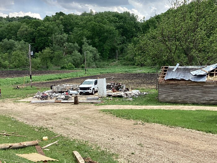
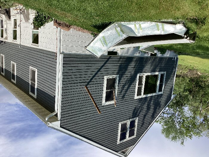
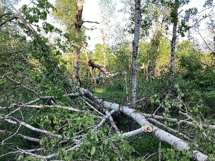
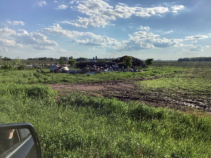
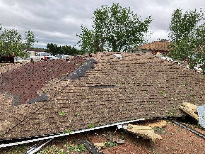
Storm and Wind Damage
 |
 |
 |
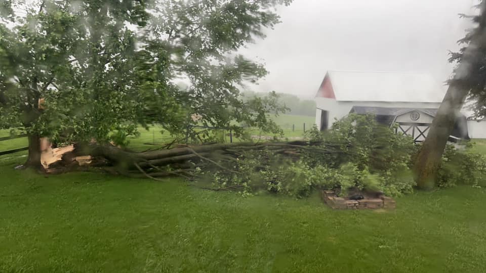 |
| Storm approaching Viroqua, WI (Vernon Co. Emerg.Mgmt) |
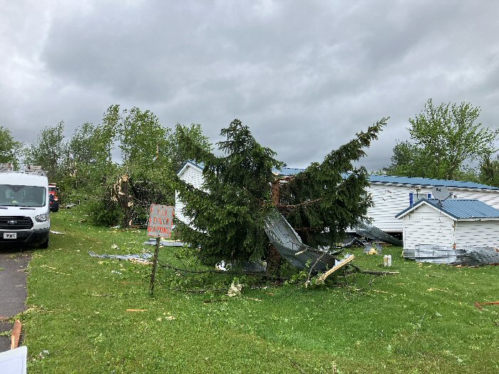
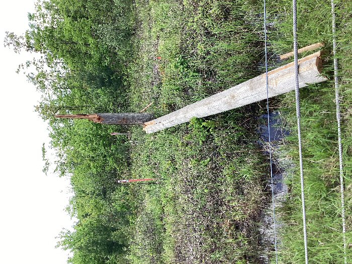
Damage in Unity, WI (NWS Survey) |
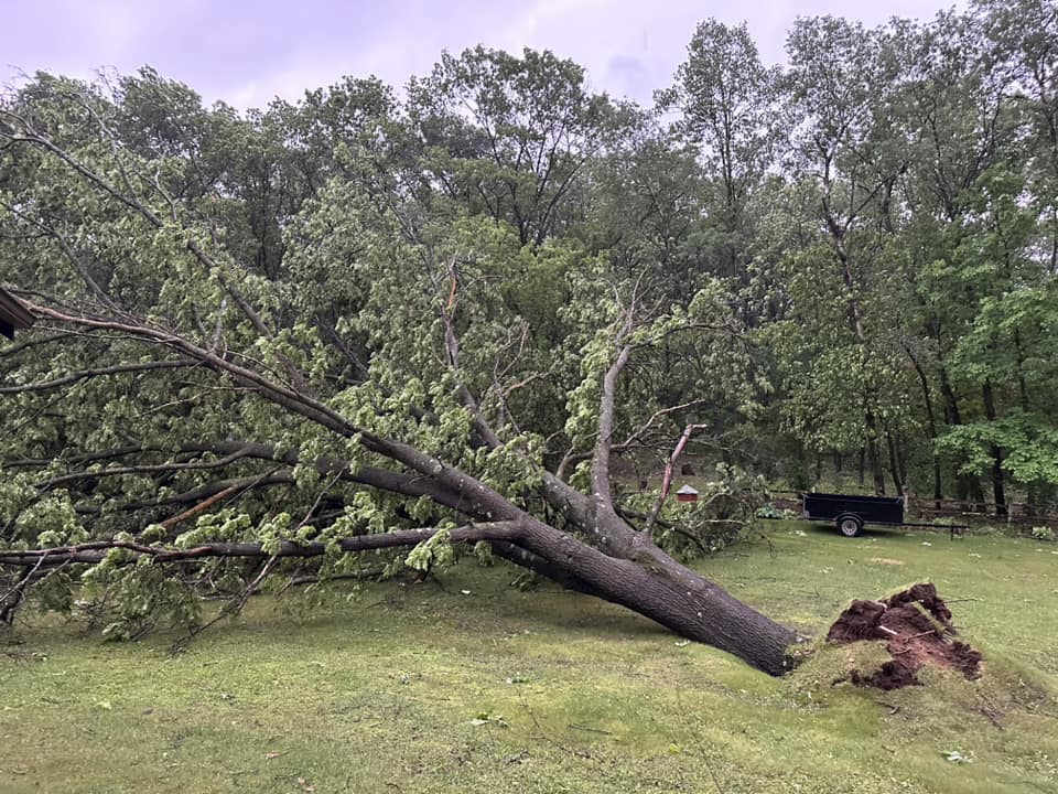
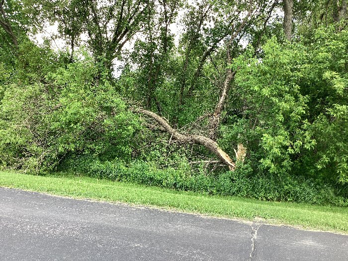
Tree damage near Rockland, WI (Carol Maulsby) |
Tree damage at Middle Ridge, WI (Lauren Olson) |
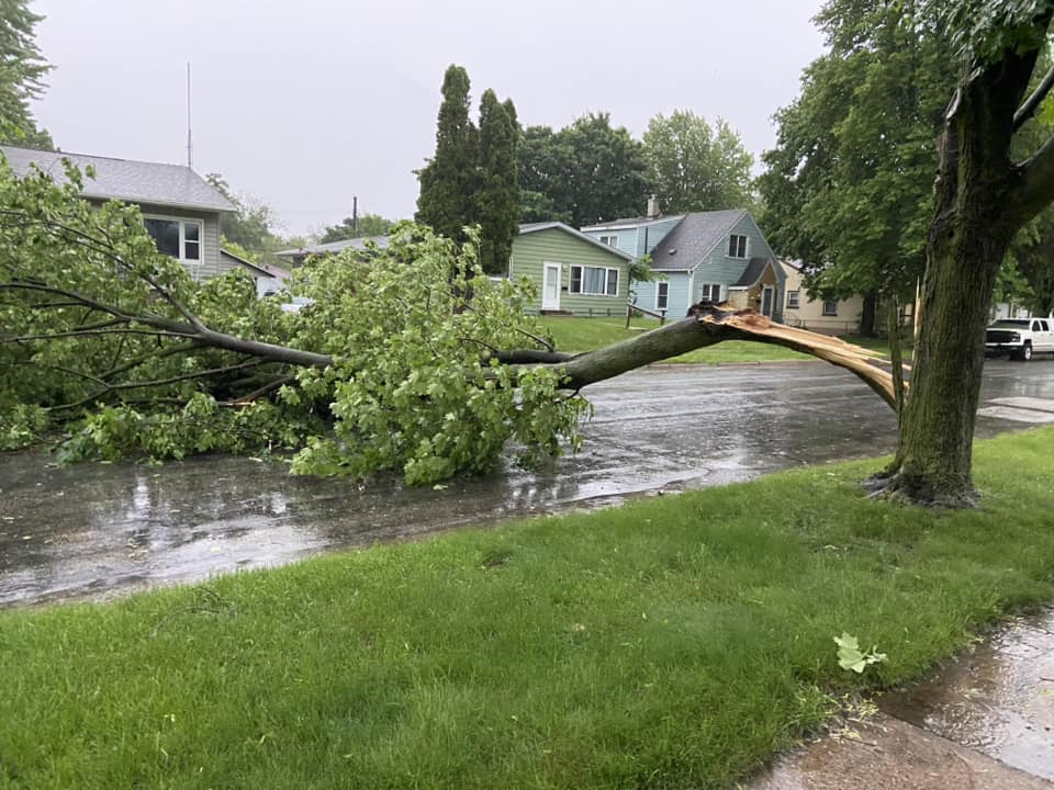 |
| Tree damage in north La Crosse (Becky Snider) |
Services
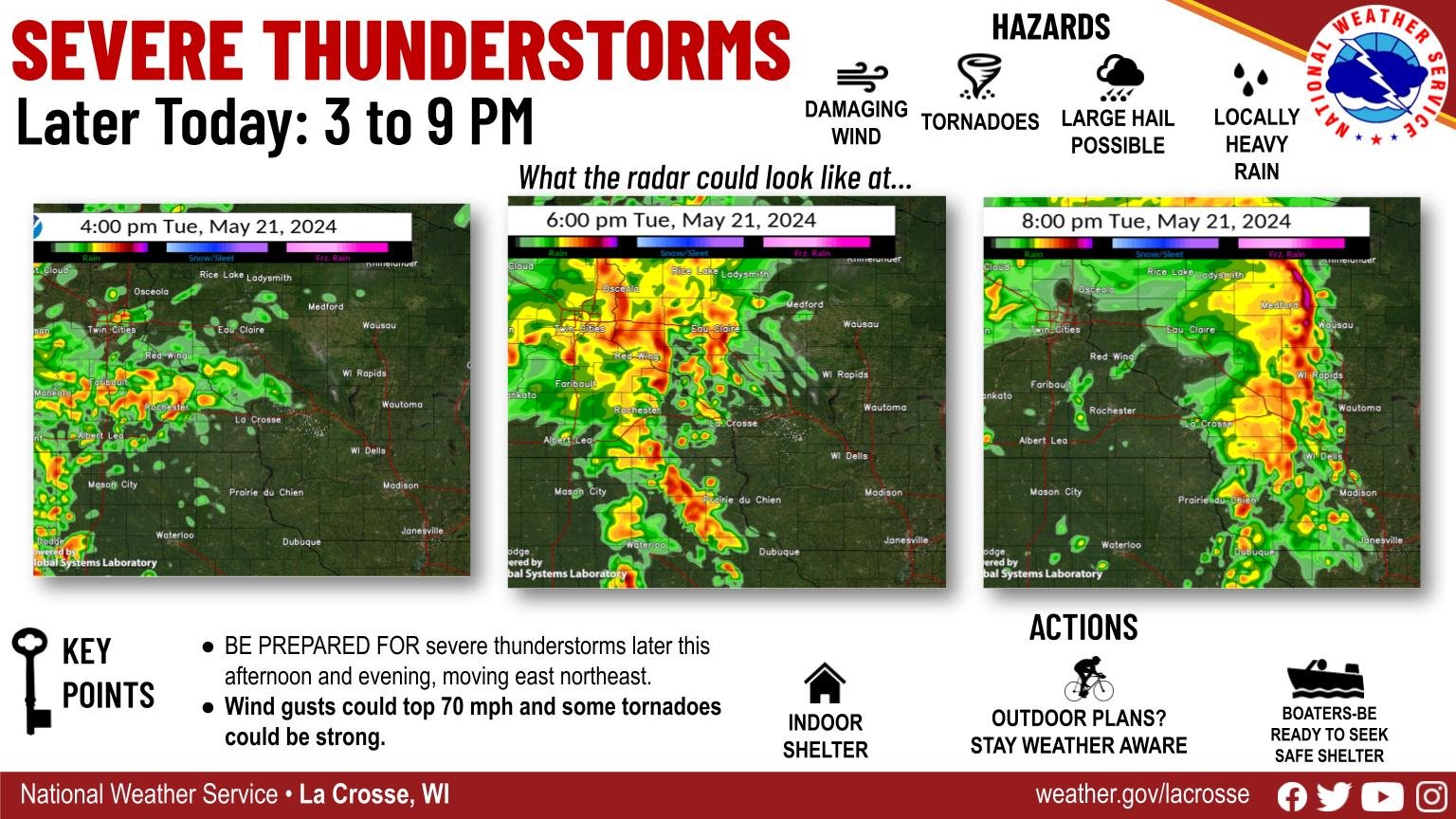
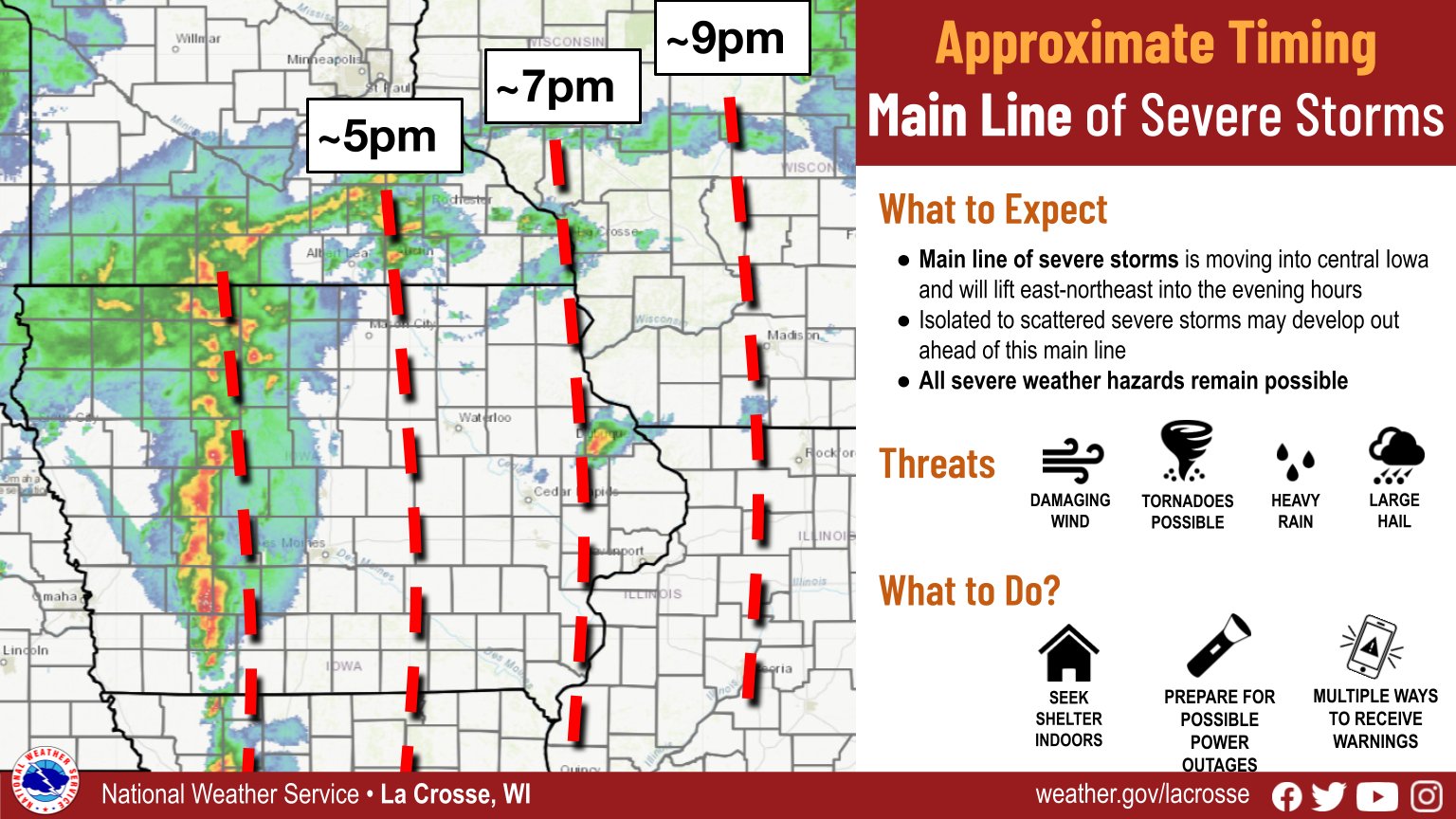
Graphics
 |
 |
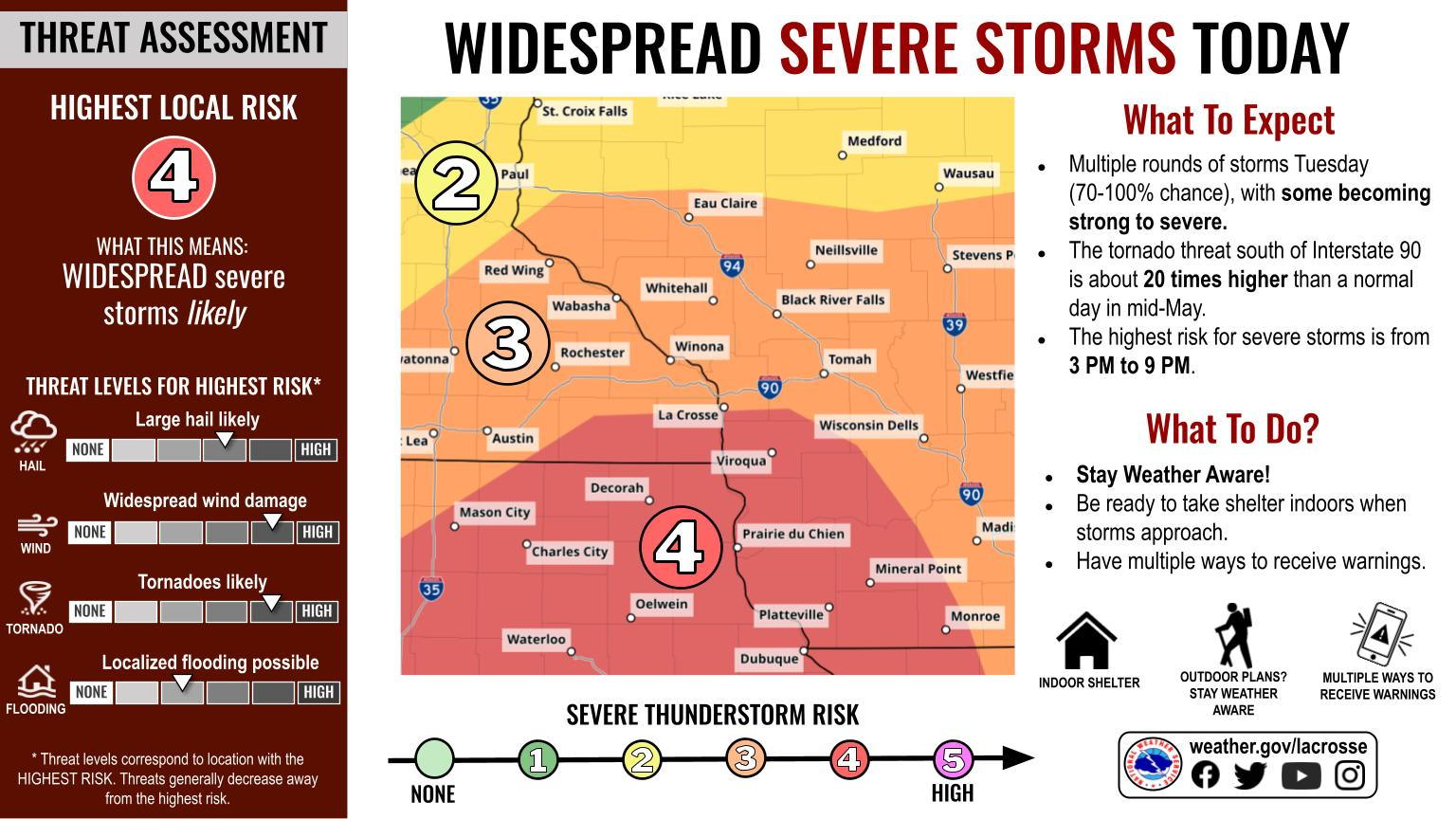 |
| Planning / Timing Graphic | Storm Timing Graphic | Preparation Graphic |
Watches and Warnings
 |
 |
 |
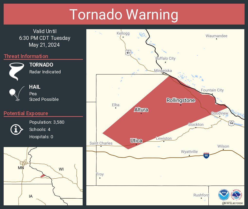 |
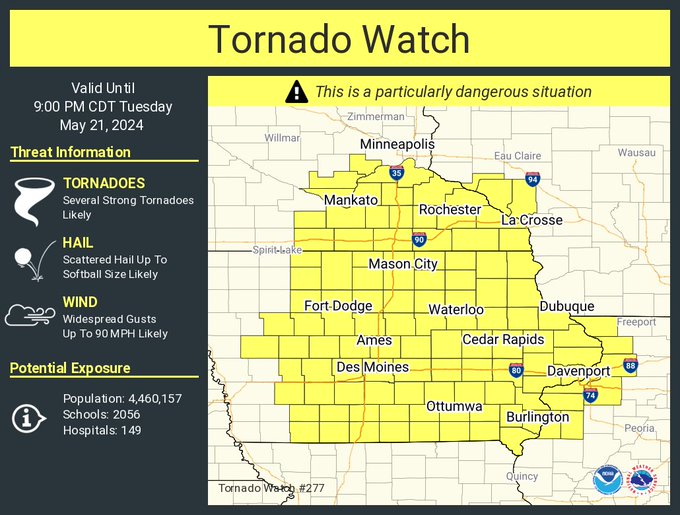
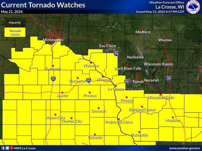
| Tornado Watch #277 | Tornado Watches Expanded | Tornado Watch #281 | Tornado Warning for Winona Co. example |
SPC Outlooks
 |
 |
 |
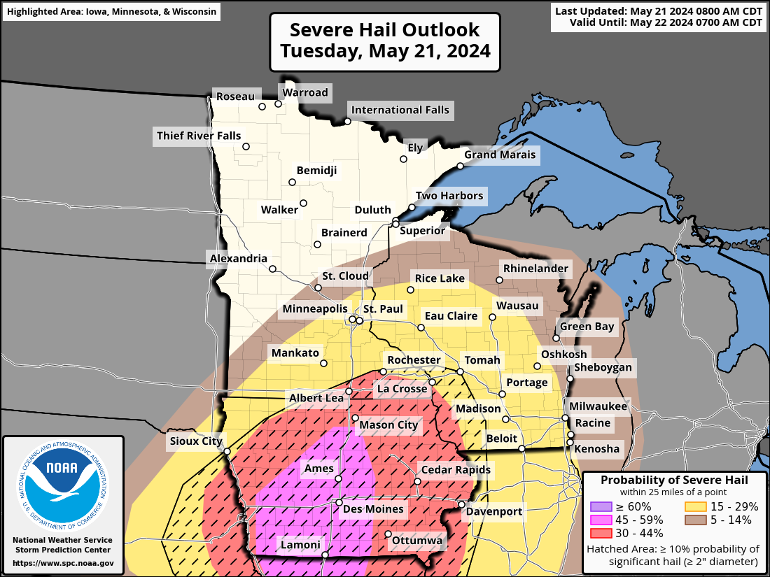 |
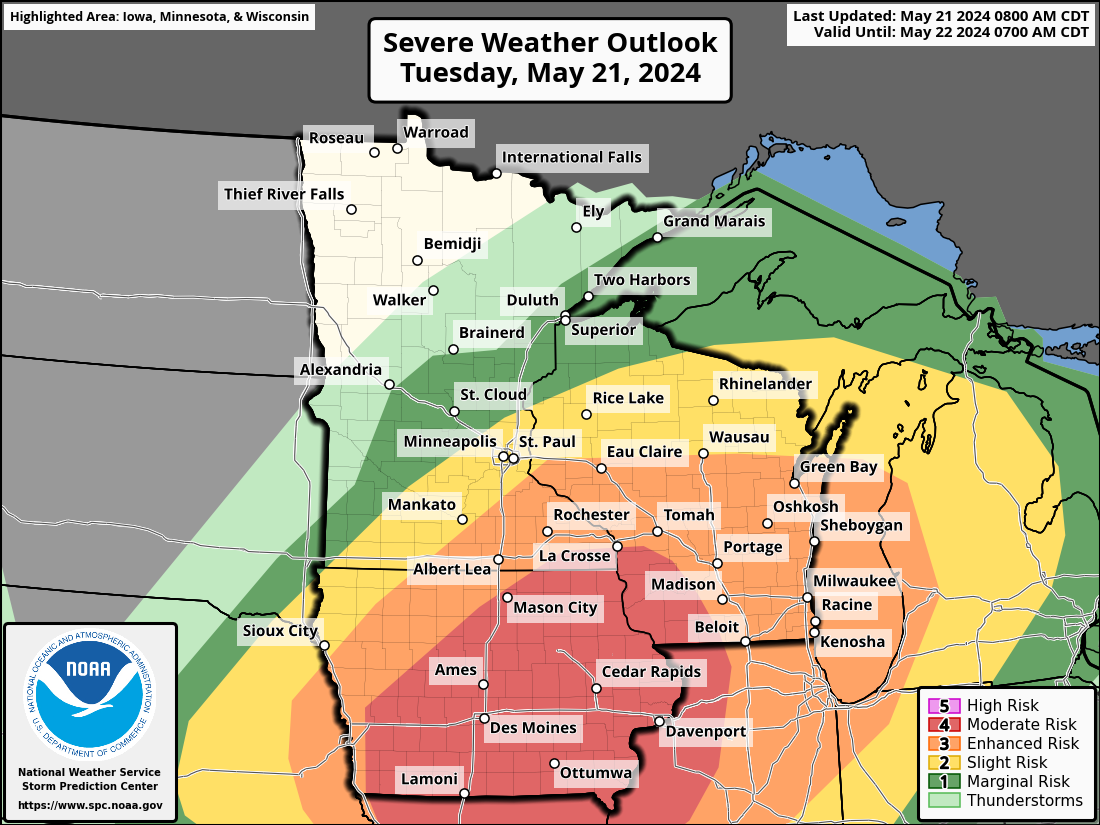
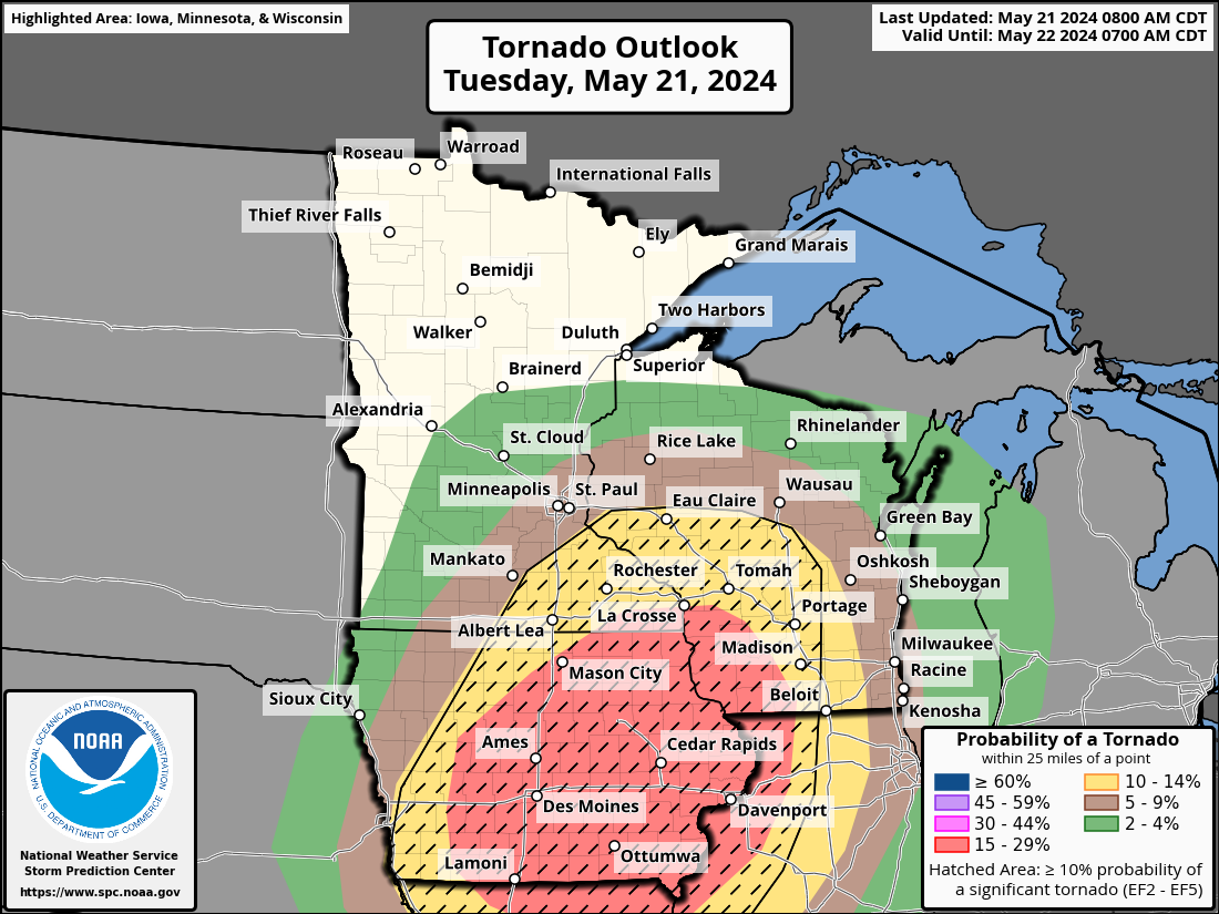
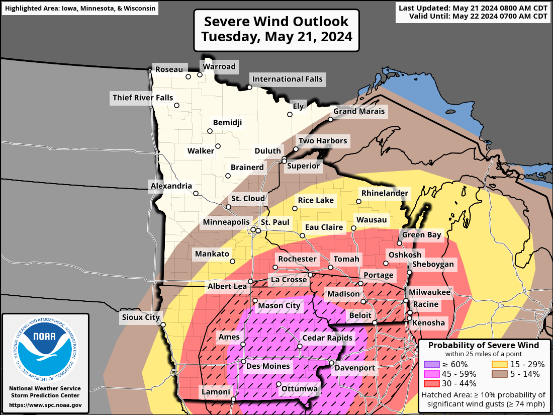
| Day 1 Outlook | Day 1 Tornado Probabilities | Day 1 Wind Probabilities | Day 1 Hail Probabilities |
 |
 |
 |
 |
| Day 1 Outlook | Day 1 Tornado Probabilities | Day 1 Wind Probabilities | Day 1 Hail Probabilities |
 |
 |
 |
 |
| Day 2 Outlook issued May 20 |
Day 3 Outlook issued May 19 |
Day 4 Outlook issued May 18 |
Day 5 Outlook issued May 17 |
 |
Media use of NWS Web News Stories is encouraged! Please acknowledge the NWS as the source of any news information accessed from this site. |
|


 Weather Story
 Weather Map
 Local Radar