|
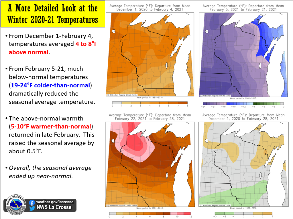
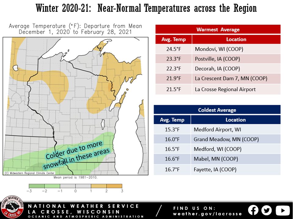
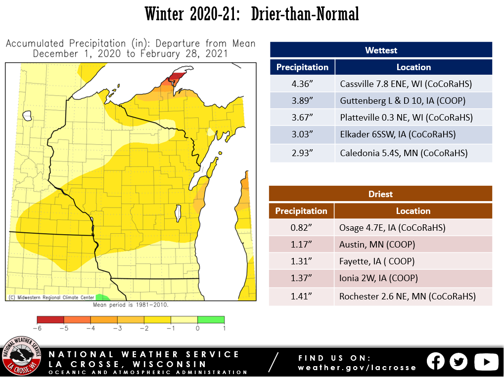
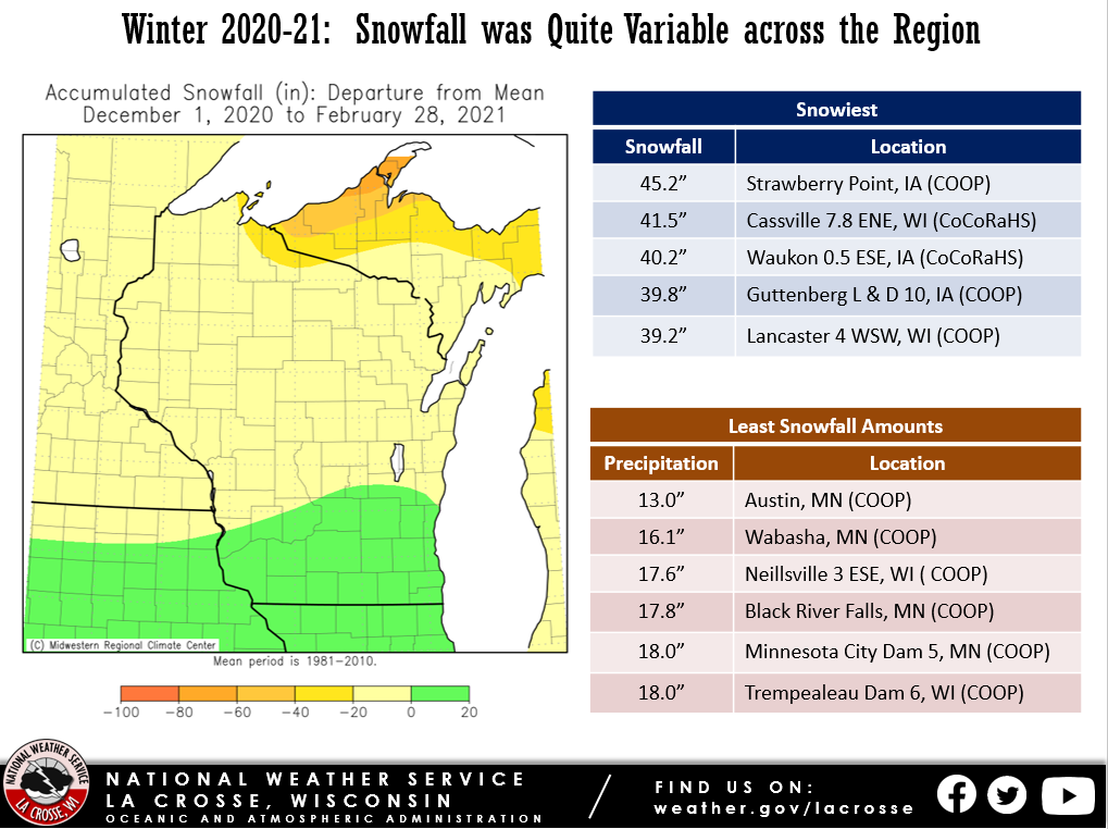
During the 2020-21 meteorological winter (December 1-February 28), temperatures averaged near-normal across the Upper Mississippi River Valley. Seasonal average temperatures ranged from 15.3F at Medford, WI to 24.5F at Mondovi, WI. While the seasonal temperatures averaged near-normal, much of the winter actually saw above-normal temperatures (4 to 8F warmer-than-normal). The temperature seasonal average was dramatically lowered by the February 5-21 Arctic outbreak. Temperatures during this time period were 19 to 24F colder-than-normal. Precipitation totals were generally 1 to 2 inches drier-than-normal. Precipitation totals ranged from 0.82” near Osage, IA to 4.36” near Cassville, WI. Normally, 3 to 4 inches of precipitation falls during meteorological winter. Snowfall was quite variable across the Upper Mississippi River Valley. Snow totals ranged from 13.0” at Austin, MN to 45.2" at Strawberry Point. Normally, anywhere from 25 to 35 inches of snow falls during meteorological winter. |
 |
Below are the temperature, precipitation, and snowfall anomalies for the 2020-21 meteorological winter.
 |
 |
 |
| Temperature Anomalies | Precipitation Anomalies | Snowfall Anomalies |
Here are more details on the winter for La Crosse WI and Rochester MN...
Meteorological winter (December 1 through February 28) was slightly warmer- and drier-than-normal at La Crosse Regional Airport. The information below provides more details on these statistics.
Temperatures - Slightly Warmer-than-Normal
From December 1st through February 28th, the average temperature at La Crosse Regional Airport was 21.2 degrees. This was 0.7 degrees warmer than the 1981-2010 winter normal of 20.5 degrees.
The table below contains the monthly temperatures and their departures from normal for the winter of 2020-21.
Winter 2020-21 Temperatures
in La Crosse WI
Average Departure
Month Temperature from Normal
----- ----------- -----------
December 27.6 degrees + 6.0 degrees
January 23.4 degrees + 6.0 degrees - Tied for
17th Warmest
February 12.8 degrees - 9.7 degrees - Tied for
18th Coldest
Winter 21.2 degrees + 0.7 degrees
The daily average temperatures were above normal on 59 days (65.6 percent), below normal on 30 days (33.3 percent), and normal on 1 day (1.1 percent).
The temperature fell below zero 14 times. Normally, there are 18 sub-zero temperatures in a winter.
Precipitation - Drier-than-Normal
From December 1st through February 28th, La Crosse Regional Airport received 1.98 inches of precipitation. This was 1.55 inches drier than the 1981-2010 winter normal of 3.53 inches.
The table below contains the monthly precipitation totals and their departures from normal for the winter of 2020-21.
Winter 2020-21 Precipitation
in La Crosse WI
Precipitation Departure
Month Total from Normal
----- -------------- -----------
December 0.36 inches -1.00 inch - Tied for
11th Driest
January 0.89 inches -0.23 inches
February 0.73 inches -0.32 inches
Winter 1.98 inches -1.55 inches
Snowfall - Less-than-Normal
From December 1st through February 28th, the snow observer near La Crosse Regional Airport received 25.7 inches of snow. This was 5.5 inches below the 1981-2010 normal of 30.2 inches. The table below contains the monthly snowfall totals and their departures from normal for the winter of 2020-21.
Winter 2020-21 Snowfall
in La Crosse WI
Snowfall Departure
Month Total from Normal
----- -------- -----------
December 4.6 inches -6.7 inches
January 9.0 inches -1.7 inches
February 12.1 inches +3.9 inches
Winter 25.7 inches -5.5 inches
Snow Depth - Same as the Long-Term Average
From December 1st through February 28th, the official snow observer near La Crosse Regional Airport had an average snow depth of 4.4 inches. This was the same as the long-term average.
The greatest snow depth was 14 inches on February 22.
Measurable snow on the ground on 67 days (74.4 percent) this winter, no snow on the ground 23 days (25.6 percent), and trace amounts of snow on the ground 0 days (0 percent).
Meteorological winter (December 1 through February 28) was slightly colder- and drier-than-normal at Rochester International Airport. The information below provides more details on these statistics.
Temperatures...Slightly Colder-than-Normal
From December 1st through February 28th, Rochester International Airport had an average temperature of 17.9 degrees. This was 0.6 degrees colder than the 1981-2010 winter normal of 18.5 degrees.
The table below contains the monthly temperatures and their departures from normal for the winter of 2020-21.
Winter 2020-21 Temperatures
in Rochester MN
Average Departure
Month Temperature from Normal
----- ----------- -----------
December 24.7 degrees + 5.0 degrees - 20th Warmest
January 20.7 degrees + 5.0 degrees - 15th Warmest
February 8.3 degrees -12.0 degrees - Tied for
6th Coldest
Winter 17.9 degrees -0.6 degrees
The daily average temperatures were above normal on 54 days (60 percent), below normal on 32 days (35.6 percent), and near normal on 5 days (5.5 percent).
The temperature fell below zero on 20 days. Normally, there are 23 sub-zero temperatures in a winter.
Precipitation - Drier-than-Normal
From December 1st through February 28th, Rochester International Airport received 1.99 inches of precipitation. This was 0.93 inches drier than the 1981-2010 winter normal of 2.92 inches. The table below contains the monthly precipitation totals and their departures from normal for the winter of 2020-21.
Winter 2020-21 Precipitation
in Rochester MN
Precipitation Departure
Month Total from Normal
----- -------------- -----------
December 0.20 inches -1.03 inch - 5th Driest
January 1.14 inches +0.28 inches
February 0.65 inches -0.18 inches
Winter 1.99 inches -0.93 inches
Snowfall - Below-Normal
From December 1st through February 28th, the snow observer near Rochester International Airport received 24.2 inches of snow. This was 8.8 inches lower than the 1981-2010 normal of 33.0 inches. The table below contains the monthly snowfall totals and their departures from normal for the winter of 2020-21.
Winter 2020-21 Snowfall
in Rochester MN
Snowfall Departure
Month Total from Normal
----- -------- -----------
December 3.9 inches -8.6 inches
January 11.6 inches -0.4 inches
February 8.7 inches +0.2 inches
Winter 24.2 inches -8.8 inches
Snow Depth - Less than the Long-Term Average
From December 1st through February 28th, the official snow observer near Rochester International Airport had an average snow depth of 3.6 inches. This was 1.6 inches lower than the long-term average of 5.2 inches.
The greatest snow depth for the winter was 11 inches on February 22.
There was snow on the ground on 66 days (73.3 percent) this winter. Measurable snow was on the ground on 59 days (65.6 percent), no snow on the ground 24 days (26.7 percent), and trace amounts of snow on the ground 7 days (7.8 percent).


 Weather Story
 Weather Map
 Local Radar